
Chiaha . . . an Itza Maya Province in Western North Carolina – Part Five
by Richard L. Thornton, Architect and City Planner
While in command of Fort King George at the mouth of what was then called the May River, Colonel John Barnwell prepared the first detailed map of what is now South Carolina, western North Carolina, eastern Tennessee and eastern Tennessee . . . all of which was considered South Carolina at that time. It was Barnwell, unilaterally changed the name of the May River to the “King George or Altamaha River.” This was done to conceal the claim on present day Georgia and South Carolina by the Kingdom of France. He also changed the Spanish names of the islands off the coast of present-day Georgia to English names . . . to conceal the earlier presence of Spanish forts and missions. Thus, began the process of erasing the pre-British history of South Carolina and Georgia.
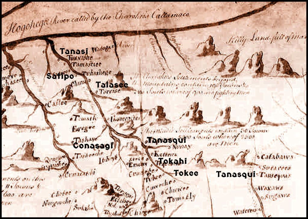
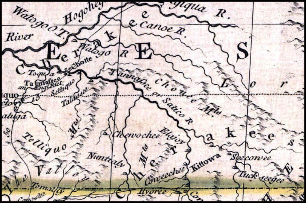
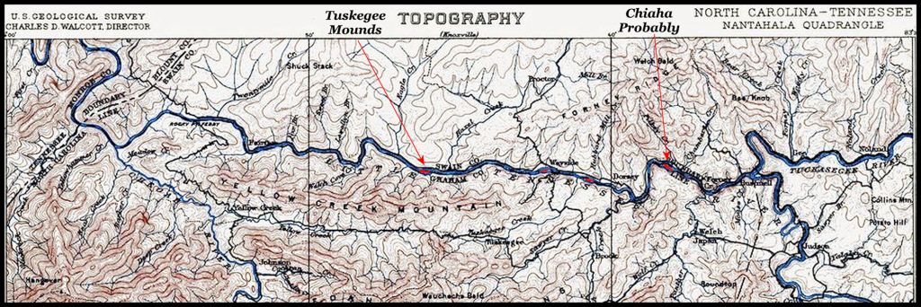
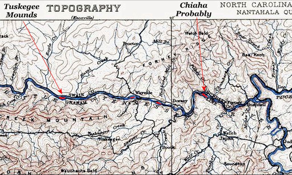
Barnwell also included the names of several Native American towns on the Tuckasegee and Little Tennessee Rivers, which appear in the chronicles of the De Soto and Pardo Expeditions. This enabled me to quickly pinpoint the general location of Chiaha. Had the 20th century academicians in the “De Soto Consortium” bothered to look at this map, they would have never placed Chiaha in Tennessee or Joara in Burke County, NC.
When the conquistadors of the Hernando de Soto Expedition entered the mountains of western North Carolina in June 1540, the fertile bottomlands Little Tennessee, Hiwassee, Tuckasegee and Oconaluftee Rivers were densely populated by culturally advanced indigenous peoples, who built both platform and burial mounds. Their town and village names represent several ethnic groups, none of them Cherokee, but these peoples had probably been mixing their genes for several centuries. Chiaha is an Itza Maya word, meaning “Salvia-River.”
The languages represented by these community names include Itza Maya (Southern Mexico), Itsate-Creek (mixed Itza, Chickasaw & Uchee), Alibaamu (Chontal Maya, Arawak & Chickasaw), Muskogee-Creek (mixture of many languages, including Chickasaw, Itza Maya, Gaelic, Latin & Illyrian), Panoan (Eastern Peru), Southern Arawak (Peru & Brazil) and Gaelic (Ireland or western Scotland). All but one of the political titles [orata], recorded by the De Soto and Pardo Expeditions, are Itza Maya in origin. Orata is the Panoan word for a village chief.
Archaeologist Bennie Keel excavated test holes or ditches at four Native American town sites in western North Carolina during 1975 and 1976 as part of his doctoral dissertation. Captain Juan Pardo probably passed through one of them, Tuckasegee, which was the most likely site of TokahE. He found significant evidence that those town sites were abandoned around 1600-1625 AD then partially reoccupied by the Cherokee around 1720 AD. The Cherokee houses were round, cruder and much smaller than the rectangular Muskogean houses in the earlier occupation.
It is likely that European diseases, introduced by Spanish explorers, Dutch traders and Sephardic immigrants caused a drastic decline in the populations of Native American towns in western North Carolina. This may have been a partial cause, but there may have also been military attacks by Europeans, Sephardic miners or Cherokees.
During the 1980s, a team of North Carolina geologists examined the timbers of several ancient gold and silver mines in western North Carolina and northern Georgia. The tree ring dates and radiocarbon dates collaborated on a period between 1585 and 1625, when these mines were begun.
While camping out in Graham County, NC in 2010, I discovered a boulder on the top of Hoopers Bald Mountain, which stated “Pre Darmos Casada – Sep 15, 1615.” That is Ladino (Sephardic Spanish) for “Prayer we will give – married September 16, 1615.”
French and Dutch maps show the Cherokees living in southern Quebec, near the St. Lawrence River, until 1650. The French Colonial Archives in the Downtown Toronto Public Library state that the Cherokees were attacked by the Iroquois Confederacy in 1649 and steadily forced southward thereafter. In his History of the Cherokee People (1826) Cherokee Principal Chief Charles Hicks stated that the Cherokees reached SW Virginia about the same time that Charleston, SC was founded (1670).
Jean Baptiste Franquelin’s 1684 only show Panoan, Creek and Shawnee towns in Tennessee. Hicks goes on to say that the Cherokees’ first town in North Carolina was Big Tellico at the confluence of the Little Tennessee and Tellico Rivers. In the years that followed, a great plague greatly weakened the “mound builders.” It was probably the 1696 Smallpox Epidemic. The Cherokees then began moving up the Little Tennessee River. Hicks said that they either killed or drove off the mound builders, burned their temples and then constructed Cherokee council houses on top of the mounds.
Eastern Creeks, direct descendants of the old Kingdom of Apalache, have a more complex memory of the past that the version of history, created by white academicians. They remember that the real Cherokees were allies until 1716, but they only lived in northeastern Tennessee and certain villages in extreme western North Carolina.
The real Cherokees were invited to settle along with groups of Sephardic Jewish refugees in SW Virginia and NE Tennessee by the Parakusa (High King) of Apalache as a barrier against the Iroquois Confederacy invaders and the Rickohocken Slave Raiders. The authority of the Apalache elite to hold their confederacy together fell apart after Charleston was settled. Waves of European diseases began decimating the populations of provinces. Highland Creeks began moving southwestward to get away from both the Rickohockens and the English.
Then most of the Rickohockens reestablished themselves from SW Virginia to where Augusta, GA now is. Vast areas of South Carolina and eastern Georgia were quickly depopulated by their slave raids. The government of the Apalache ceased to exist after the 1796 smallpox. At that point, the Cherokees replaced the Rickohockens as the main players in the slave trade, but they never attacked fellow members of the Apalachen Confederacy until 1716.
The final break-up did not occur until mid-December 1715 at a diplomatic conference held in the Uchee town of Tugaloo. (Until 1776, Tugaloo was always labeled a Uchee town on British maps.) The delegates, allied with the real Cherokees, murdered 32 of the other Apalachen Confederacy delegates in their sleep and switched sides to the British.
British officials cemented the hostility between former allies by literally creating a Cherokee “tribe” in 1725 from peoples, speaking many languages, but allied politically. Several Itsate Creek towns in the Franklin, NC area refused to join and moved south into Georgia to join the Creek Confederacy.
The ”Lower Cherokee” in South Carolina were Itsate-speaking Creeks, not ethnic Cherokees. The Lower Cherokee language is not a “lost,” untranslatable dialect of Cherokee. It can be easily translated by anyone who knows Itsate (Hitchiti) Creek. Creek tradition also remembers that some Creek towns in North Carolina contained factions that wanted to remain in place and become allied with the Cherokees, since they were growing wealthy via the Native American slave trade and friendship with South Carolina’s leaders. That explains the survival of some town names into the 1700s.
The Georgia Creek version of history explains why some North Carolina Native American towns were not abandoned around 1600-1625 or even around 1700. The names of certain towns and villages, mentioned by the chroniclers of the De Soto and Pardo Exhibitions appear on the earliest details maps of the region. These include TokahE, Conasagi, Tanasqui, Tallasi, Satipo and Taskegi.

Old maps and new photos reveal Chiaha
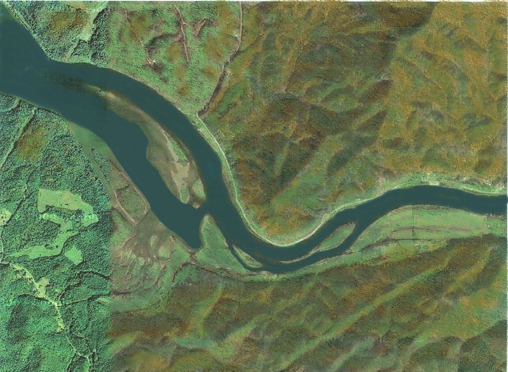
I knew that TokahE and Tanasqui were upstream from Chiaha and that Talasi, Satipo and Taskegi were downstream from Chiaha. Chiaha Olameco was described by the chroniclers of De Soto and Pardo as being immediately downstream from where four rivers joined. When the 1904 USGS topo map of the Smoky, Nantahala and Snowbird Mountains was digitized and posted online by the Library of Congress in 2017, I was able to identify four large islands on the Little Tennessee River, that were possible locations of Chiaha.
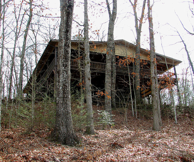
Ironically, I lived in a vacation cabin in the hamlet of Tuskeegee, NC between February 23 and April 10 of 2010. That particular cabin, a few years earlier, had been used as a hideout by Olympic Games Bomber, Eric Rudolf, after he had left the Rome, GA neighborhood in 2000, where I formerly lived. Life is indeed a box of chocolates . . . or was it an accident?
That made my task much easier. Chiaha Island was somewhere along a five mile (8 km) of Fontana Lake to the east of the Taskegi Mounds. Oh, there was one problem. The island was covered by Fontana Lake and my canoe was in a rental storage bin near Blairsville, GA. That five-mile section of shoreline was privately-owned land, inaccessible by foot or car. It would be 2017 before high resolution maps were available online, which displayed the appearance of the Little Tennessee River before the creation of Fontana Lake.
One LANDSTAT satellite image from 2017 was taken in the winter, when the water level of Fontana Lake was lowered enough to see the mounds of Chiaha. However, when Google Earth Pro began offering historic satellite images, I found the February 2015 satellite image in which part of Chiaha Island was also visible.

The largest mound is located at
35°26’29.0″N 83°37’35.9″W.
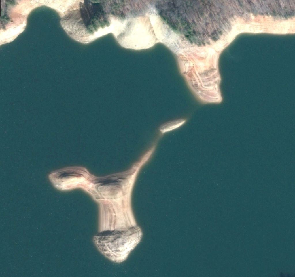
What is particular interesting about the real location of Chiaha is that the mounds are arranged in an identical pattern to those at Kaushe (Kusa) which was a younger town. It makes me wonder, if the elite of Kaushe originated in the Province of Chiaha. For archaeologists to answer that question, they first have to know that there is such a question.

Now you know!

Hey Bro thank you for illumination on a history that most people are not aware of. I do enjoy the history you a firm grasp of.I went to YHC the late 70s and found the trackrock area then I ask my history professor about it he gave the Cherokee bs about dancing areas. I called BS on that.Thanks Richard
LikeLiked by 1 person
There is a group of historic preservationists and amateur archaeologists in Union County, GA are making moves to get the Track Rock Gap area transferred from the US Forest Service to the Georgia Dept. of Parks and Historic Sites. That archaeological zone will never be leased to lumber companies, so why pretend that it is a commercial forest and not a world class archaeological zone?
LikeLiked by 1 person
Greetings. I’m a teacher of history in Cashiers, NC and I have followed your articles on and off for a while.
Who owns that island?
September-November would seem to be the best time to get some photography and explore that island to see. I wouldn’t even know what I would be looking for if I got out to it.
LikeLiked by 1 person
Hey Aaron
Fontana Lake and all its islands are owned by the TVA, but when I was camping along Fontana Lake in 2010, I also saw National Park Service rangers patrolling or at least traveling on its waters. You might want to check with the TVA office at Fontana Dam to find out when the water will be at its lowest level. I think what is most interesting is that the mounds on the island are in the same exact arrangement as those of the great town of Kaushe (Coosa) which is under the waters of Carters Lake in the NW Georgia Mountains.
Richard T.
LikeLike