
Part Six of “The Forgotten Peoples of the Southern Highlands”
by Richard Thornton, Architect and City Planner
Few, if any readers, are probably familiar with the ethnic name, Casquinambaux (French) or Caskenampo (English), but they are recorded in the French and early South Carolina Colonial Archives as the most powerful tribe in what is now eastern Tennessee . . . that is, until after 1708. Their name disappears from the maps, other than a river’s name, after that time.
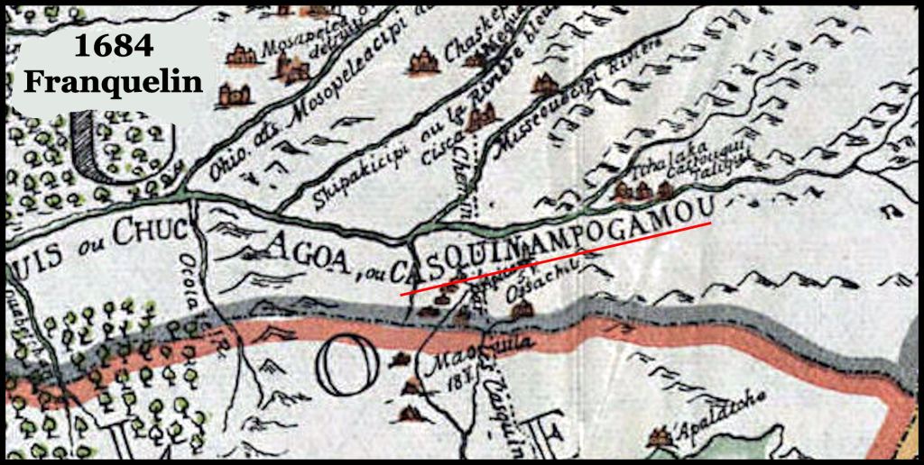
Casquinambaux (or Caskenampo) was not mentioned in the Hernando de Soto or Juan Pardo Chronicles, even though both expeditions passed through the region, where the name later appears on maps. Its first appearance is on the 1684 map of North America by Jean Baptiste Franquelin. I will go ahead and tell you that it is a combination of two Koasati words that mean “Warriors – Many.” Nampo means “how many” in Alibaamu (Alabama).
The reason that I used the virtual reality image for Cholahuma at the top was that I suspect that the area around Cholahuma on the Little Tennessee River is where the Koasati language originated. Cholahuma was an Alibaamu town within the Itza-Maya/Itsate-Creek speaking province of Chiaha. The Koasati language is a mixture of Itza Maya, Itsate Creek and Alibaamu. Alibaamu, itself is a Cho’ite Maya word.
Dixie anthropology professors say the darndest things!
When mentioned at all in the academic literature today, Caskenampo is usually found in academic papers or books by professors in eastern Tennessee or in Cherokee history. Both the professors and the Cherokee-files state that Casquinampo was a name that the late 17th century French explorers used for the Cherokee. The authors use this statement to explain the lack of a word similar to Cherokee on any map of southeastern North America until 1715. They go on to say that the Chaloque was the Spanish word for Cherokee.
Chalogue, Chiliqui or Chalague, as mentioned by chroniclers of the De Soto Expedition, is NOT a name for the Cherokee. Later maps place them in southeast Georgia and then on the Chattahoochee River as members of the Creek Confederacy. Their name is ether derived from the Totonac, Itza Maya and Itsate Creek word for “primitive barbarians.”
Over the years I have found several statements in academic papers and internet blogs equating Caskenampo with Cherokee. Most give no source for this statement, but if they did, they just wrote [Hanna, 2003]. Hanna appears to have been a professor somewhere, but I can’t find out much more about him or her. However, recently in a professional archaeologists’ blog, I found actual quotes from Dr. Hanna. In WordPress, it is not possible now to apply a red color to a specific word for sentence within the paragraph, so I have instead put a [number] to flag sentences, which are caca de toro . . . which is basically the entire paragraph.
Here is the quote:
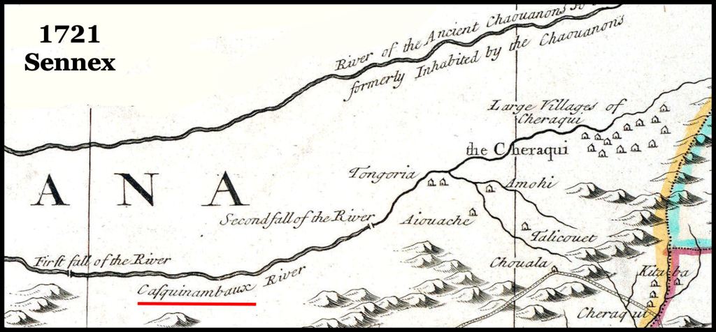
“We look at Franquelin’s 1684 map of North America. Between the Upper Forks of the “Casquinampogamou” are located three Cherokee villages, bearing the names, “Tchalaka”, “Cattogui” {Katowagi was the Shawnee name for the Cherokees), and “Taligui” [Chillicothe] the last name being identical in sound with the “Talligewi” of Lenape tradition as given by Heckewelder. [1] (On one of De l’Isle’s maps the Tennessee River is called “Riviere des Casquinambaux ou Cheroquis”. [2] The name “Casquinampo” probably comes from the “Casqui” or “Casquin” Indians referred to by some of the chroniclers of De Soto’s expedition.” [3]
“Gatschet writes of Tukabatchi, a town of the Upper Creeks, on the Tallapoosa River, one and one-half miles below its falls, whose original inhabitants were of an alien tribe, afterwards amalgamated with the Creeks, [4] The town anciently was known under two other names: “Ispokogi” or “Italua Ispokogi”, said to mean “town of survivors” or “surviving town, remnant of a town”, and “Italua Fatcha-sige”. Milfort says (p. 265) that nearly about the same time that the Alibamons were admitted into the Creek Confederacy, “an Indian tribe which had just been destroyed [scattered] by the Iroquois and the Hurons came to ask protection of the Muskoquis, whom I shall now call Creeks.” [5]
“The Creeks received them, and gave them lands in the center of the Nation. They built a town which is at this day [1802] of some importance, and which is called “Tuket Batchet”, from the name of the tribe.” Judge Force, in commenting on this passage {Indians of Ohio), suggests that it is within possibility that the Tukaubatchies were a surviving remnant of the Eries. [6] The resemblance of “Ispokogi”, one of the names of their town, to “Kispogogi”, the name of one of the Shawnee clans, suggests the probability that the “Tuket Batchets” were Shawnees. [Italu/Etowah=Town; Ispokogi and Fatcha-sige unknown]” [7]
Multiple Mistakes by the professors
[1] Dr. Hanna didn’t even look at the maps that he described. Only the last (1718) map that De L’Isle ever published even mentioned the Cherokees and he placed them on the Holston and Nolichucky Rivers, not the Tennessee. The tribal names are Chalaka, Catalou and Taliqui. Chalaka was an important Shawnee town that moved to the Tallapoosa River in Alabama to escape Rickohocken slave raids. Catalou was a Creek town that moved to the Middle Chattahoochee River for the same reason. Talliqui (Talike) is a Muskogee Creek tribal name, not Cherokee!
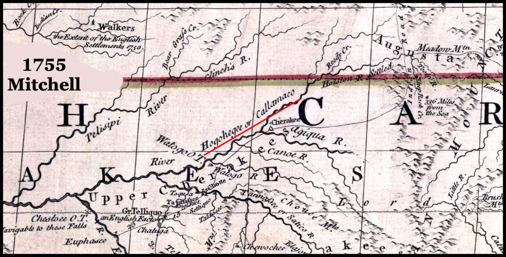
[2] As you will see on the maps below, that statement is a lie. No De L’Isle map has that statement. Some do say, “Casquinamboux ou Callimaco.” Callimaco is an Itza Maya word that means “House of the King” or “royal palace.” This false statement is the source of Caskenampo = Cherokee.
[3] As said earlier, Caskenampo is an easily translatable Koasati word. The town of Casqui in western Tennessee was probably founded by Kosasati.
[4] & [5] That comment by Gatschet referred to Shawnee refugees from the Ohio River Valley, who fled Iroquois attacks and joined with the Creeks in eastern Alabama. This statement has nothing to do with Caskenampo or Tuckabatchee.
[6] & [7] No, Tuckabatchee was inhabited by Muskogee-speaking Creeks from the Southern Appalachians. Over and over again, I find ludicrous interpretations of the past by Gringo anthropology professors, who analyze the Frontier English spellings of Native American tribes and villages. It never dawns on them to learn the actual phonetics spoken by natives or to buy a Native American language dictionary.
Analysis of the maps
Unlike these professors, I actually look at the original maps . . . not quote what a professor said in college.


Conclusion
Caskenampo was the name of an alliance of Muskogean towns and villages on the Tennessee and Little Tennessee Rivers, which means “Many warriors.” It was a descendant of the Province of Coça, visited by the Hernando de Soto Expedition in 1540. They apparently spoke a dialect of the language that linguists now call “Koasati.” An alternative name for this alliance is “Upper Creeks.”
Now you know!

Howdy, The MAPS are much more readable in your new posts.
On Wed, Mar 2, 2022 at 9:06 AM The Americas Revealed wrote:
> alekmountain posted: ” Part Six of “The Forgotten Peoples of the Southern > Highlands” by Richard Thornton, Architect and City Planner Few, if any > readers, are probably familiar with the ethnic name, Casquinambaux (French) > or Caskenampo (English), but they are recorded in ” >
LikeLiked by 1 person