
Location is adjacent to the Chattahoochee River, next to a large Creek Indian town and the intersection of several major regional trade routes
by Richard L. Thornton, Architect & City Planner

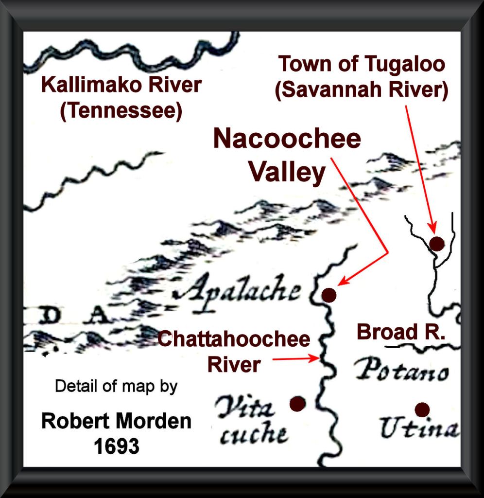
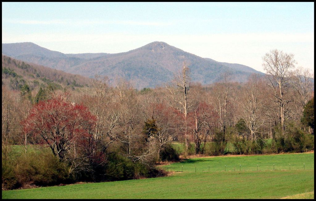
The Nacoochee Valley is located along the headwaters of the Chattahoochee River in Northeast Georgia. Its northern flank is defined by the Blue Ridge Mountains. Its eastern and southern flanks are defined by ancient volcanos of varying age. Its western flank is defined by the Yeona Mountains. Yeona means “mountain lion” in Asturian. Many of the 17th century gold miners in the valley came from Asturia and northern Portugal.
Chattahoochee is the Anglicization of the Itza Maya words Cha’ta Hawche, which mean “Carved stone – shallow river.” Yes, that’s right . . . it was the Chattahoochee National Forest Office of the US Forest Service that funded the “Maya-Myth-Busting-In-the-Mountains” political campaign . . . with your tax money!
Immediately north of the probable Spanish occupation site was the large capital town Itsate. Itsate is the Itza Maya word meaning Itza People. It is now the village of Sautee and contains numerous mountain and earthen platform sites.
Until the early twentieth century, Sautee was located about three miles to the northeast on Sautee Creek. Sautee (Sawte in Maya) is the Itza Maya word for the Zoque or Soque People from Mexico, who are believed to be the progenitors of the so-called Olmec Civilization. The Olmecs were a Nahuatl People, who arrived in the region about 1500 years after the “Olmec” Civilization disappeared.
The northwestern tip of the Nacoochee Valley nowadays is occupied by Helen, GA, which is Georgia’s number three tourist attraction. Helen sits on top of the Tabasco Maya/Creek town of Cho’i-te . . . which whites called Chote. This Chote long predates by many centuries, the better known Cherokee village of Chote in Tennessee, which first appeared on the maps around 1752. Valley is 87 miles northeast of Downtown Atlanta.

Etymology
Apalache was the name that many Middle and Lower Creek Indians called themselves when the colonies of South Carolina and Georgia were settled. It is a Panoan word from Peru, which means “From ocean (or Upper Amazon Basin) – descendants of.” The Apalachee in Florida never called themselves by that name until their Spanish overlords told them that was their name. In the 1600s, the Apalachen Confederacy (or Kingdom of Apalache) stretched from southwestern Virginia to southwestern Georgia. That alliance unraveled at the tail end of the 17th century due to repeated waves of European diseases and the Native American slave trade. It was replaced in 1717 by a Creek Confederacy, dominated by the Coweta Creeks.

Archaeological survey
Throughout 1939, the famous archaeologist Robert Wauchope intensely investigated many parts of the Valley and surrounding areas, while employed by the WPA. [Wauchope, 1969, An Archaeological Survey of Northern Georgia] He determined that the Nacoochee Valley had been occupied continuously by humans from the Ice Age onward. Without looking for them, he unearthed 35 Clovis points in alluvial soil covering much later village sites. He identified mounds from the Archaic, Woodland, Transitional and Early-Late Mississippian Periods. Many of the towns and villages were almost contiguous and were occupied from the Archaic Period through the late 1600s. What was interesting was that individual contemporary villages contained unique styles of residential and communal architecture, typical of the Uchee, Chickasaw and several branches of the Creeks.
Until around 1600 AD, all of the artifacts were typical of indigenous peoples of Georgia, in particular the region around Macon, GA. Beginning at the approximate 1600 AD level, he began finding an increasing percentage of European artifacts. The greatest concentration of European artifacts were in the vicinity of where remote sensing suggests was the Spanish fort, trading post and mission. These included a wide range of tools, weapons and ceramics. Wauchope even excavated swords and harquebuses (matchlock guns).
Around 1700 AD the entire flood plain of the Chattahoochee was covered with a thick layer of alluvial sand, sometimes 15 feet deep. Almost all artifacts found above that layer are of European or Anglo-American manufacture. European-type farmsteads were sparsely scattered across the landscape. In 1810, US Indian Agent for the Southeast, Benjamin Hawkins, estimated that the total American Indian population of the entire Upper Chattahoochee-Soque River Basin was about 125 people!
Wauchope never found any structures or artifacts associated with the Cherokee at any occupation level . . . including the 1800s. This tells us that although the Cherokees were given the Nacoochee Valley in the 1784 Treaty of Augusta, few, if any, ethnic Cherokees ever lived there. Yonah Mountain did not have its Cherokee name until 10 years after the Native Americans were gone from the valley. It was given a Cherokee name by white settlers from North Carolina. The Native occupants of the valley sold their lands voluntarily to a North Carolina real estate speculator then moved to Creek lands in Alabama.

To learn detailed accounts of the work of archaeologists Charles C. Jones, Jr, Cyrus Thomas, George Heye, Robert Wauchope, Arthur Kelly and Mark Williams in the Nacoochee Valley . . . plus a detailed history timeline of the region, you can read my 2017 book, The Nacoochee Valley . . . Ancient Crossroads of the Americas. It can be ordered online from my publisher, Lula Publishing (cheaper and also a $15 digital version) or from Amazon.com.

Colonial Era history of the Valley
The Nacoochee Valley may have been visited by Juan Pardo, but it was definitely visited by Lt. Laroche Ferrière from Fort Caroline in 1564 and 1565 during his six month exploration of what is now Georgia. Ferrière reported to Captain René de Laudonnière, commander of Fort Caroline that he had traveled up the May River (Altamaha River) from Fort Caroline to the Kingdom of Apalache and spent considerable time with them, since they seemed as advanced as the Natives of Mexico and had enormous gold deposits in their realm.
Six survivors of Fort Caroline, probably including Ferrière, were allowed to settle in the Kingdom of Apalache, provided that they agreed to marry Apalache (Creek Indian) gals. After meeting their prospective brides, there were no objections from the French bachelors.
The Apalache were monotheistic. They worshipped an invisible, omnipotent sun goddess, who lived in Mexico, but had almost all the traits of the Hebrew YHWH. There were two important differences between Apalache religion and Hebrew religion. Apalache women were considered equal with men in all things and could even rule the kingdom. Secondly, all forms of human or animal sacrifice were forbidden. No blood of any kind could be shed within one Creek mile (approximately two English miles) from a temple or sacred site.
The Frenchmen eventually converted the Apalache elite to Protestant Christianity . . . with the exception that the Apalache continued to believe that God was a woman . . . since only a mother could love her children, despite their many failings.
Archaeologist Robert Wauchope found the tomb of Roanoke Colony survivor Eleanor Dare and her daughter, dating to 1599. He excavated stone tablets, written in Elizabethan English and the Apalache writing system near the tomb. He also unearthed a stone tablet two feet under the base of a large hill upon which sat the home of Eleanor’s Apalache husband and herself. In Elizabethan English it stated that this is where Elyoner Dare lived for the last ten years of her life. Wauchope was also given 24 stone tablets, carved by the colony’s survivors in the Valley, which had been found by farmer’s plowing fields over the previous 100 years. We will explain at the end, why you don’t know about these tablets.
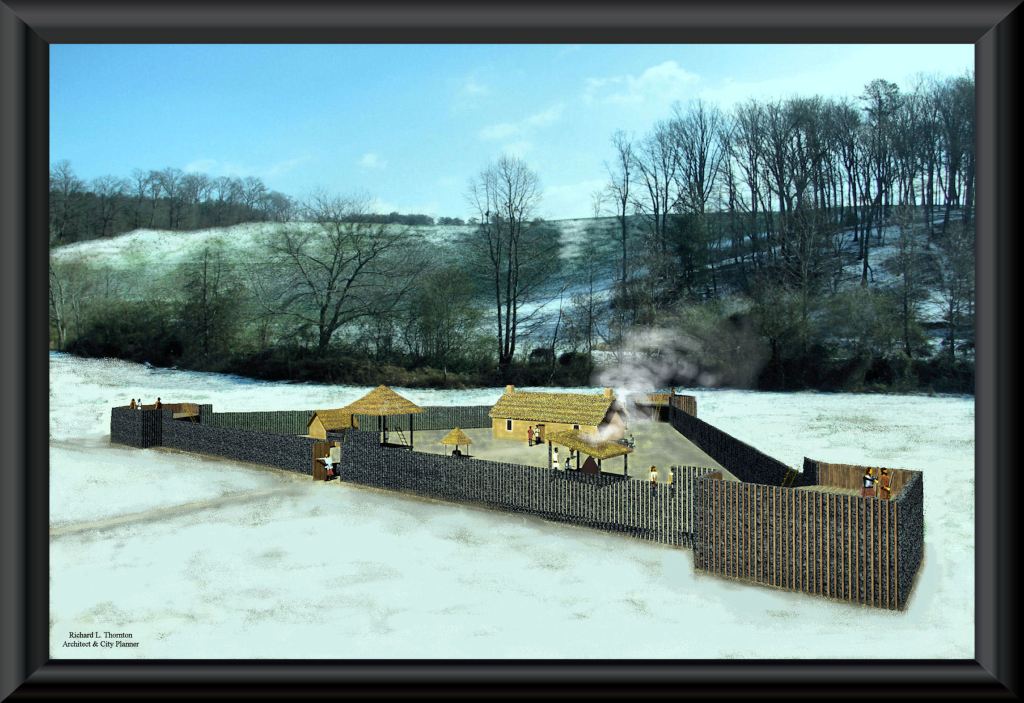
In 1646, Governor Benito Ruíz de Salazar Vallecilla of La Florida, received permission from the Parakusa (High King) of Apalache to build a road from St. Augustine to the headwaters of the Chattahoochee River in the “Apalachen”* Mountains then construct a trading post at its terminus . . . states the official Florida History textbook.
*Apalachen is the plural of Apalache in the Georgia Creek language, which is different than Muskogee.
That same year, Edward Bland, arrived at Jamestown, Virginia after living and working as a merchant in Spain. He immediately requested a private meeting with Governor William Berkeley. Soon thereafter, Bland headed south to “the southern tip of the mountains to look after some investments” . . . says the official Virginia History textbook. It is obvious that Bland had invested in the Nacoochee Valley trading post along with Governor of La Florida.
The official North Carolina History textbook changed the story told in the Virginia Commonwealth Archives. It states, “Upon arrival at Jamestown in 1646, Edward Bland heard of the power of the Cherokee Nation and immediately headed south to the North Carolina Mountains, where he met in council with the Great Cherokee Chiefs. He became the first Englishmen to meet the Cherokees.” Actually, all maps show western North Carolina occupied by Creek and Shawnee towns until 1715.
The official Georgia History textbook says nothing about the Kingdom of Apalache, Richard Brigstock, Spanish colonists in North Georgia or James Moore’s visit to the Nacoochee Valley, etc. In fact, like its North Carolina counterpart, it incorrectly infers that the Cherokees lived in North Georgia for hundreds of years. I frequently get inquiries from Georgia history teachers on Creek history, because they know that the contents of their textbook is fake history that dates to 1990s, when State Senator then Governor Zell Miller was trying to get a Cherokee gambling casino built near the Track Rock Archaeological Zone.
Richard Brigstock, a planter from Barbados, spent most of 1653 as a guest of the High King of Apalache. He was a cousin of Edward Bland. Brigstock was considering a move by a group of Barbados planters to what is now Georgia, because Barbados was under siege by a fleet of the English Commonwealth Navy. Most of the planters in Barbados were Royalists. Brigstock liked the Apalachen Mountains, but found the climate too cold for sugar cane, plus human slavery was forbidden in the Kingdom of Apalache. Brigstock moved to Virginia instead. Most of his group, however, moved to the coast of South Carolina, because it had a climate suitable for sugar cane, indigo and rice.
Brigstock spent considerable time at the Spanish fort, trading post and mission in the Nacoochee Valley. He described it as being near the capital and palace of the High King. Very few of the Indians were interested in converting from Protestantism to Catholicism, so the mission primarily functioned as a chapel for the Spanish miners, who were allowed to settle in Apalache, if they took Creek wives.
Upon returning to the Caribbean Basin, Brigstock told French naturalist Charles de Rochefort everything he had learned, while living with the Apalache, plus gave him his sketches of their world. As a result, De Rochefort added ten chapters about what is now the State of Georgia to the second edition (1658) edition of L’Histoire Naturelle et Morale des isles Antilles de l’Amérique. Over the next 40 years, the very popular book was published six more times in several languages.
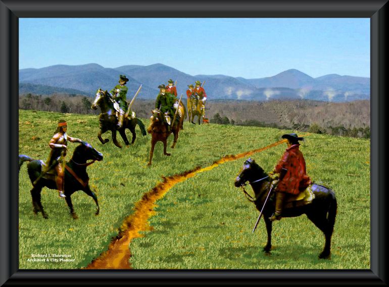
In 1693, Governor James Moore of South Carolina led a mounted expedition of Redcoat cavalry and Indian guides to investigate rumors of “white men living in the Apalachen Mountains. Arriving at a point, approximately where I live, the troop observed many smoke plumes, which the Indian guides explained were Spaniards and Apalaches smelting gold. The South Carolinians beat a hasty retreat, knowing that they were outnumbered.
During the early 1830s, gold miners unearthed the ruins and artifacts of two Spanish mining villages. They were buried under 15 feet of alluvial soil, but also included hundreds of Spanish artifacts. Many other European and exquisite Apalache artifacts were unearthed by gold miners. These discoveries were publicized by Georgia newspapers at the time. Also, Charles C. Jones, Jr. included discussions of the early Spanish colonists in North Georgia in his landmark book, Antiquities of the Southern Indians. However, after Charles C. Jones passed away, knowledge of the early European presence in the Georgia Gold Belt was erased from the history books.
More on Robert Wauchope
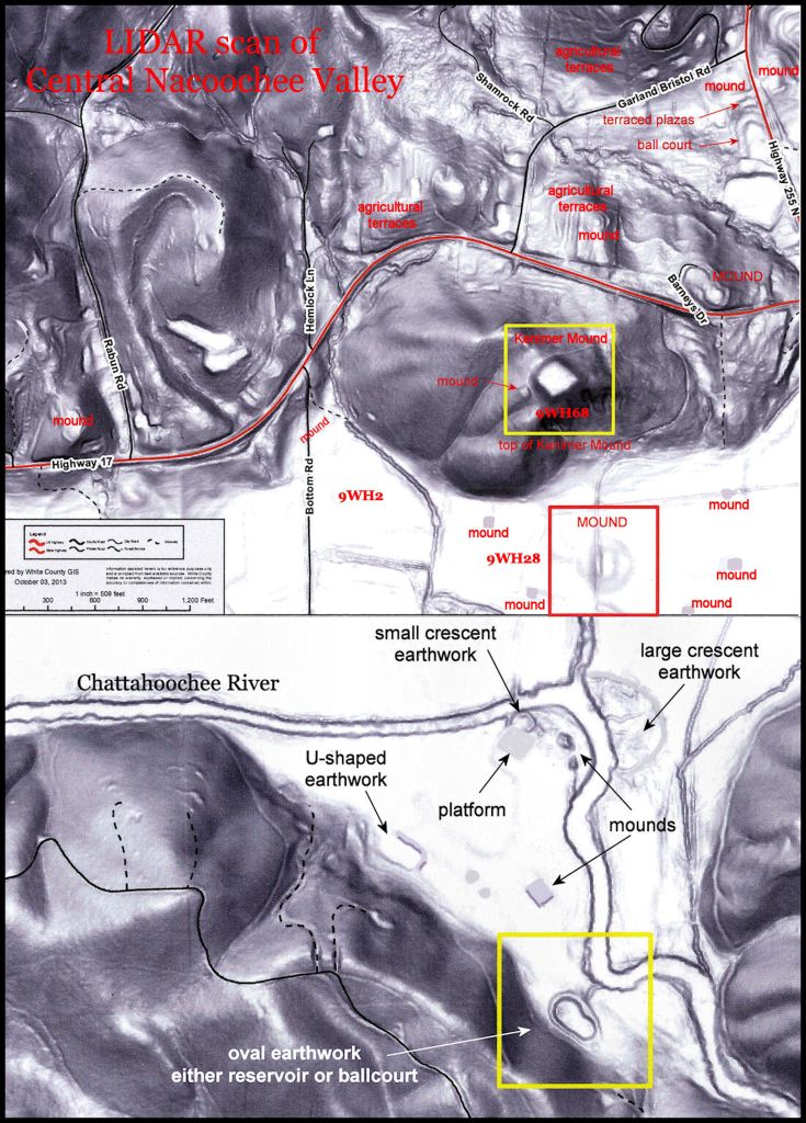
In 1939, the young archaeologist, Robert Wauchope was hired by the WPA to carry out a comprehensive archaeological survey of northern Georgia. He was soon stunned by the shear number of town sites and mounds in the region. Except for Etowah Mounds and the Nacoochee Mound, the region had received very little attention from mid-20th century archaeologists. That is still the case. The year that he had been allotted was not nearly enough time to survey every county in the region. Then he discovered the Nacoochee Valley. It was essentially a seven mile long, continuous archaeological zone. Indeed, today it is now one of the nation’s largest National Historic Districts.
Wauchope spent most of that year in the Nacoochee Valley, but still didn’t complete his survey there or in the rest of northern Georgia. He has already identified 38 major archaeological sites in the valley, but missed several large mounds, because he assumed that they were hills. He returned to the valley on weekends, while teaching at the University of Georgia, but suddenly was hired away by the University of North Carolina. Wauchope never finished his survey of North Georgia or prepared a report to the federal government as required by his WPA contract.
Families in the Nacoochee Valley are still quite upset that he never returned the vast quantity of Native American and European artifacts that he “borrowed” from them. No one seems to know what happened also to the artifacts that he and his WPA laborers excavated from 32 archaeological sites in the Valley. The artifacts belong to the private property owners, where they dug.
Here is what happened. North Carolina officials and economic leaders became quite upset when they learned that Wauchope had excavated proof that several of the key Roanoke Colonist had ended up in the Nacoochee Valley. Nearby Brenau College was performing a drama about their story, based on the artifacts in Wauchope’s possession. Wauchope was offered a position at the University of North Carolina, paying three times his salary at the University of Georgia, if he agreed to leave UGA immediately during Fall Quarter. Apparently, he also signed a 20 year non-disclosure agreement. He did not return to Georgia for 20 years. Only in the 1960s did write the book on his work in Georgia . . . and it was prepared as a report to the Society for American Archaeology. Very few people were aware that it was even published . . . so his discoveries of European artifacts and proof of the Roanoke Colonists essentially remained a secret to the general public.

I’ve always known that the Spanish were in Nacoochee Valley and that several of the “hills” in White County are in fact mounds. There is a hill on the right side side of Highway 129 between Cleveland and Gainesville (if you’re headed toward Gainesville) that I have always believed to be a mound. It sits on farm property and has an old abandoned barn on it can that hardly be seen anymore because of all the trees. And the hill in Nacoochee Valley that I believe you said was the site of an observatory (the hill with a house on top of it now), I always knew it was not just a hill. I don’t know how I knew these things, maybe genetic memory, if you believe in that.
LikeLiked by 1 person
It means that you are smart and observant. Many people drive along a highway and never really see what they are looking at.
LikeLiked by 1 person