It’s real name is currently unknown!
by Richard L. Thornton, Architect and City Planner
GPS Coordinates: 32° 1′ 28.02″ N, 85° 2′ 39.98″ W
Few people outside of the Lower Chattahoochee River Basin have ever heard of this ancestral Creek town, but it is one of the larger and most precisely planned indigenous towns in the USA. Roods Creek Mounds (9SW1) is located south of Omaha, Stewart County, Georgia at the confluence of Rood’s Creek and the Chattahoochee River. The US Army Corps of Engineers’ Rood’s Landing Park is on the river at the edge of the town, so it is also known as Rood’s Landing.

Rood’s Creek was a Middle Woodland – Mississippian Period town (c. 200 AD-1700 AD) containing eight earthen pyramids. It was entered on the National Register of Historic Places on August 19, 1975. Some anthropologist, probably from North Carolina or Tennessee, has inserted that it was part of the Southern Appalachian Mississippian Culture. Evidently, they hoped to someday claim that it was built by the Cherokees . . . 700 years before the Cherokees arrived in the Southeast.
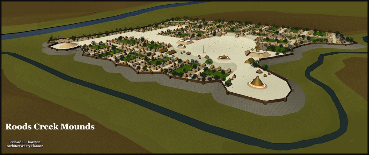
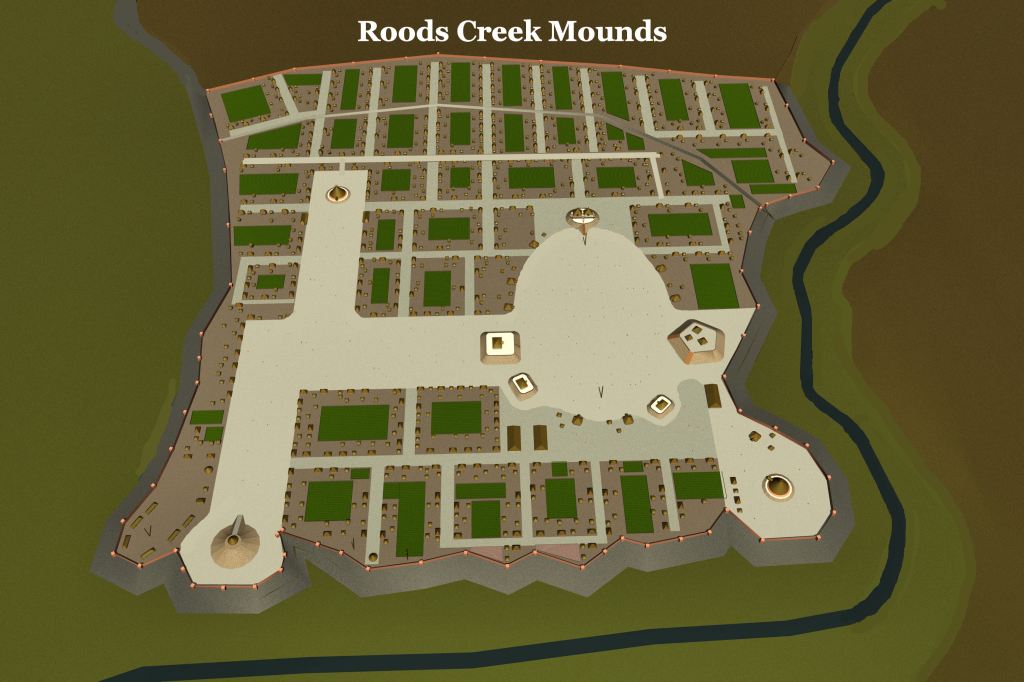
Architecturally and town-planning-wise, it was very different than the Proto-Creek towns, built in the Piedmont and Southern Appalachians. In fact, it was one of the more Mesoamerican looking towns built in the Southeast. That is very obvious from looking at my architectural renderings.
What it does resemble are the Post-Classic towns in the Coastal Plains of southern Veracruz and Tabasco that I visited on my fellowship in Mexico. Many of these towns were inhabited, at least partially, by Chontal Maya traders. They only built earthen pyramids and had asymmetrical town plans. Being that we have known since 2012 that Chontal traders obtained large quantities of attapulgite from the Chattahoochee Basin (and probably even large quantities of mica from the Upper Chattahoochee River) it is quite possible that Roods Creek was founded by traders from southern Mexico’s coast. Much of the town population, though, would have ultimately been Muskogeans. This is most likely an ancestral town of the Apalachicola Creeks.
Architectural description
The original village covered about 10 acres near the confluence of the creek with the river. Several centuries later a planned, fortified town was developed over about 50 acres. This was later expanded to 85 acres and then over 100 acres.
The largest mound at the site is Mound A, which is the only structure that has been thoroughly excavated. It is currently 7.6 meters (25 ft) in height, with a base, and summit measuring 44.2 meters (145 ft) by 38.1 meters (125 ft). On its summit was 3 wattle and daub structures, which were stuccoed with yellow clay. This mound had a 3 feet (1 m.) clay parapet around the edge of the summit. Structure 1 was located at the center of the summit and the other structures were arranged around it to either side. The mound had two ramps leading from the summit (with openings in the clay parapet structure) to the ground level, each measuring 15.2 meters (50 ft) in length, 4.5 meters (15 ft) in width where they join the summit, and 7.6 meters (25 ft) where they meet ground level. One faced northwest on a plaza opposite Mound E, the other lead to the southwest.
Archaeological investigation
Shortly after the turn of the century, artifact collector/archaeologist Clarence Bloomfield Moore attempted to excavate the Roods Creek Site. However, he was denied permission. The site was partially excavated in 1955 by archaeologist Joseph Caldwell for the US Army Corps of Engineers, but has not been excavated since. It is accessible only through pre-scheduled tours, conducted by US Army Corps of Engineers Rangers.
Virtual Reality views of Roods Creek


Wow, cool! I enjoy all you post, but this is above things.
My ancestors always had a large tobacco patch behind the longhouse. An old joke was a palisade wasn’t so much to slow enemy invaders, but slow deer from eating all the tobacco. Even a ripgut fence, something that deters hogs and other animals, wouldn’t stop deer in their joy to tsilov, tobacco.
LikeLiked by 1 person
Thank you!
LikeLike
Howdy, WELL DONE!!!
On Tue, Mar 22, 2022 at 7:29 AM The Americas Revealed wrote:
> alekmountain posted: ” It’s real name is currently unknown! by Richard L. > Thornton, Architect and City Planner GPS Coordinates: 32° 1′ 28.02″ N, 85° > 2′ 39.98″ W Few people outside of the Lower Chattahoochee River Basin have > ever heard of this ancestral Creek town, but” >
LikeLiked by 1 person
Thank you sir!
LikeLiked by 1 person