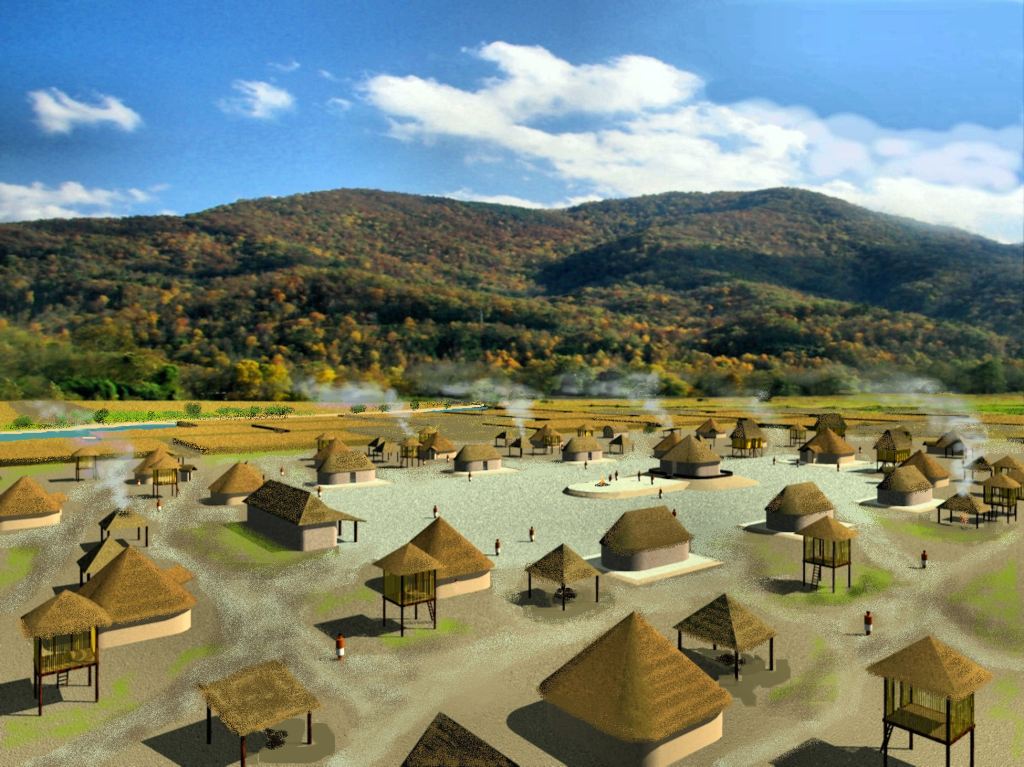
Suddenly around 1000 AD, numerous Indigenous American towns with mounds like this one appeared in present-day Georgia, Alabama, Tennessee and western North Carolina. Within a short period, those towns in northern Georgia and western North Carolina, were making the same style pottery as found in Etowah Mounds.
Part 23 of The Americas Connected series
by Richard Thornton, Architect and City Planner
Graham County, NC ~ March 2010 – Here, I was standing on Tallulah Road (Hwy. 129) next to the Talula Mound, North Carolina’s best preserved Native American mound, and in a perfectly preserved archaeological zone, adjacent to a major highway. Professional archaeologists from the NC State Office of Historic Preservation had excavated test ditches and extracted significant amounts of Native American artifacts from several strata. Yet, the 1000-year-old Talula Mound was intentionally NOT listed on North Carolina’s list of Indian Mounds nor on the National Register of Historic Places. What the heck was going on?
Etymology
Tallulah, Talula and Tulula: These are Anglicizations of the Itza Maya word, taa – lu – la, which is pronounced, Täw : lo͞o : l [ˈɑ]. The word is derived from the Totonac word for a large town tula, but ultimately is derived from the Maya word for a type of construction, involving the stacking of field stones, taula. The word for stone, tauli. is the same in Itza Maya and the Creek languages.
Taalula was absorbed into the Eastern Creek (Itsate) language, where it is written as tvlula. In Muskogee-Creek the word is written as tvlofa. In all three languages, the word originally meant “a one mound or one public building district administrative town,” but now typically means a small town or significant village.
During the summer of 2022, our articles on “cultural exchanges from the south” articles will proceed chronologically. This is so the reader will be able to understand what was known and unknown at any given time. Just like in Mexico, I kept a journal, which I used for writing articles in the National Examiner. It was Roger Kennedy’s idea. Until his cancer suddenly returned, Roger planned for me to convert the journal and photographs that I was taking, into at least one article in National Geographic Magazine.
It should made clear that my comprehension of what I was discovering came incrementally. Basically, through a several year period, I had to do time travel in my brain as I accessed long-stored memories in my brain, re-read books in my library and for the first time, read my journal in Mexico.
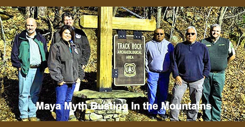
Maya-Myth-Busting in the Mountains
The so-called “Track Rock Gap Controversy” had nothing to do with science, Native American history or archaeology and everything to do with a very toxic political environment now poisoning that region of the country. Massive amounts of illegal drugs are either being manufactured or distributed from the Southern Appalachians. While I was living near Dahlonega, GA a $350 million-a-year meth operation was headquartered across the street from the county fire department headquarters and one block away from the Sheriff’s Department. Nevertheless, all of the main participants, were able to escape the United States, when one of the organization’s manufacturing facilities in Dahlonega was raided.
Parts of the profits from the “protected” drug dealers are being utilized to buy control of local/state law enforcement and governments, plus promote the agenda of those who wish to create a pseudo-theocratic, one-party police state in the United States. Homeland Security didn’t seem to take my warnings seriously until the January 6, 2021 attack on the National Capitol. Now I am getting “some” protection.
Contract employees of the National Security Agency (NSA) and Georgia state law enforcement officers took an active role in the “Maya Myth-Busting in the Mountains” campaign by the US Forest Service. The phones and internet connections of law-abiding citizens were put under surveillance illegally. US Dept. of Defense satellites were utilized illegally by NSA contract personnel to monitor movements of civilian vehicles. NSA employees in Augusta, GA even telephoned honest citizens, who they were watching with satellites and threatened them.
Oh, did we mention that for years archaeologist Johannes Loubser, who excavated three test holes at the Track Rock ruins, was either an NSA intelligence asset or an actual employee of the NSA? The newspapers certainly didn’t tell you that.
More specific to our series . . . When I published the Examiner article about Track Rock Gap on December 21, 2011, very few archaeologists in Georgia or the United States knew that the terrace complex existed. Even fewer had actually seen the ruins. The site plan, produced by an associate of Johannes Loubser, left out large areas of terraces and man-made features, which apparently Loubser never saw. Loubser was completely unaware that large numbers of “Mexican style artifacts in tombs” were unearthed by road workers, when Track Rock Road was reconstructed in the 1970s. Absolutely no one, myself included, knew that there were at least 21 terrace complexes in or near the Georgia Gold Belt, which stretches from east-central Alabama to NW South Carolina.
However, in 2010, 2011 and 2012, I knew very little about the extent of a lost civilization in the Southern Highlands and even less about all of this corruption. I was just a homeless, near-penniless architect, trying to get back on my feet and on with my life. I still hoped to meet a woman, with whom I could share my life with. Meanwhile, some sort of “federal agents,” who were not FBI, were going around the Cherokees and local law enforcement, telling them that I was a gay male prostitute with AIDS.
While I was camping out in the North Carolina and Georgia Mountains, local residents perceived me (just like in other foreign countries – LOL) to be someone “important.” They pleaded with me to tell “someone” that US Forest Service personnel, former TVA executives, TVA police, state police officers and NSA employees, pretending to be FBI agents, had helped Olympic Games bomber, Eric Rudolph, evade the FBI in the most expensive manhunt in that agency’s history. These same traitors intentionally painted local residents as the “bad guys.” Local families also told me that there were many retired narcotics policemen and US Air Force officers from Florida, building “millionaire-type” houses in western North Carolina.
The interim years
In February 1969, Dr. Arthur Kelly showed me artifacts unearthed from near the Lower Chattahoochee River, which he interpreted as being from Mexico or being copies of Mexican artifacts. Actually, while on my fellowship in Mexico, I realized that they were Chontal Maya artifacts from Tabasco.
Dr. Román Piña Chan, my fellowship coordinator in Mexico, assumed that Mesoamericans had transported Mexican seeds to North America. It was never considered an offbeat theory . . . or even a theory. In truth, however, the Mexican-North American connection was an issue that never really concerned me for many decades.
I returned to Mexico in late 1970, 1974, 1980 and 2000. However, soon after I returned to Atlanta after the 1970 fellowship in Mexico, organizations and anthropology professors began asking me to give slide lectures. In 1970, 1971 and 1972, I taught Pre-Columbian architecture classes at Georgia Tech. From then until I was shanghaied in South Metro Atlanta in 1993, I was frequently asked to give slide lectures on Mesoamerican architecture to college students and archaeological societies. Thus, I continued to expand my library and knowledge of Mesoamerican civilizations throughout my adult life.
This continued intellectual growth was especially true in Virginia, when three of my friends were the nationally known archaeologists George Stuart, Gene Stuart (National Geo) and Bill Gardner (Thunderbird Associates). Several of the universities, which invited me to speak had national or international reputations. Not being up to date on Mesoamerican research would have reflected badly on them and also my friends in the National Park Service Center at Harpers Ferry, WV.
HOWEVER, I never significantly changed the color slide tray that I prepared for a lecture before the Atlanta Archaeological Society and Georgia State University community in 1974. Thus, I never looked at most of my slides from Mesoamerica, after I stored them in slide trays in the autumn of 1970!
In contrast, my knowledge of my own Creek-Uchee heritage changed little from winter/spring 1969, when I prepared the site plan for Arthur Kelly’s Site 9Fu14 on the Chattahoochee River in SW Metro Atlanta and then in the autumn of 1969 took a tour of the Etowah Mounds with Arthur Kelly and Lewis Larson. That situation changed dramatically in 1995, when I moved into a townhouse near Etowah Mounds.
Horrified at Etowah Mounds
Nevertheless, in 1995, I instantly noticed that the recently remodeled Etowah Mounds Museum was telling people many lies. I told this to the site manager, who herself was a Georgia Creek. I even showed her a copy of the Etowah Mounds Archaeological Report, which she did not know existed. University of Georgia professors had told her that no report had ever been printed. She added though that the State of Georgia had spent a great deal of money . . . modifying exhibits and creating new ones. She insisted that all this work had been guided by the faculty of the University of Georgia’s Department of Anthropology. She added, “They obviously knew more about the subject than some architect, recently arrived from Virginia.”
Nope, you will have to watch my video on Youtube to know the true history of Etowah Mounds. The photo above is sufficient proof that the same people, who brought you “Maya Myth-busting in the Mountains,” have been hoodwinking the public for at least three decades.
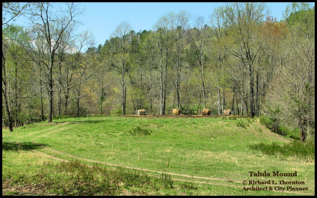
The Talula Mound
I first noticed the Talula Mound when driving into Robbinsville, NC for the first time on February 23, 2010. It was snowing and there were several inches on the ground, so I didn’t stop. In my Explorer were two large waterproof plastic containers, filled with archaeology books. I was taking advantage of being homeless by finally reading all the books on the Southeastern Indians, which I had purchased during the previous 15 years!
I had been invited to move into a vacation home on Fontana Lake for the rest of the winter. That sure beat living in a tent! I had to wait until the weather warmed up some in March to give the mound a close look.
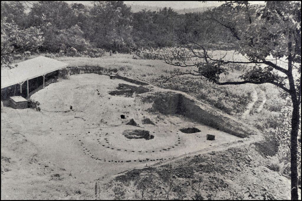
There was no state historic marker, but this was obviously a large mound . . . being used to store hay bales. There were some potshards in the exposed mud near the mound. I measured the mound in order to created a computer model of it. The mound covered over an acre and originally had been about 15-20 feet tall.
I next went to the Graham County Library to check on any email. Practically no one knew that I was homeless, so I kept up pretenses by answering emails quickly.
The chief librarian was also a scoutmaster and a history enthusiast. He said that the mound was called the Talula or Tulala Mound. About 10 years ago (c. 2000) it had been studied by a retired archaeologist from Florida, who said that state archaeologists had probed the mound in the 1970s or 1980s and found artifacts similar to those at Etowah Mounds in Georgia. The Florida archaeologist speculated that the mound had been built around 1000 AD.
I next visited the Snowbird Cherokee branch office of the Eastern Band of Cherokees Cultural Preservation Office. The Snowbird Cherokees were friendly.
I asked the staff archaeologist why the Talula Mound was not on the North Carolina Mound List. He said that it was because of the artifacts the archaeologists found. I asked him what that meant. He lowered his voice, so no one else could hear . . . “because they were not Cherokee.”
With a louder voice, he added, “Well, I have my hands full in the Andrews Valley. Wealthy people in Charlotte and Atlanta began buying up land in the Valley after the Murphy Cherokee Casino was announced. The first thing they do is bulldoze any mound on their property. In a little over one year’s time, twelve mounds have been bulldozed. I am trying to stop two more bulldozings!”
The sad thing is that the new Cherokee casino has had a negative impact on communities such as Andrews, NC. The population of Andrews is virtually stagnant after dropping catastrophically in the 1990s. Many buildings, oriented to the tourism industry, are unoccupied now. There have been no developments on the lands, where mounds were bulldozed.
What Dr. Arthur Kelly discovered
None of the reservoirs created in western North Carolina or the portion of Georgia, north of the Blue Ridge Mountains, were studied by archaeologists. That is still the situation for the North Carolina lakes. The retired archaeologist from Florida did a thorough investigation of Lake Santeetlah when it was drained. He found lots of 16th century Spanish artifacts, suggesting that either the De Soto Expedition came through there or Juan Pardo built a fort there or both. His report was ignored by North Carolina archaeologists and the NC State Office of Historic Preservation.
In contrast, while Dr. Arthur Kelly was Director of the University of Georgia Department of Anthropology in the 1940s, 1950s and 1960s, he often took teams of students up to the Georgia Mountains, lakes and rivers for summer archaeological courses. My friend, Gene Stuart went on the one to Lake Chatuge.
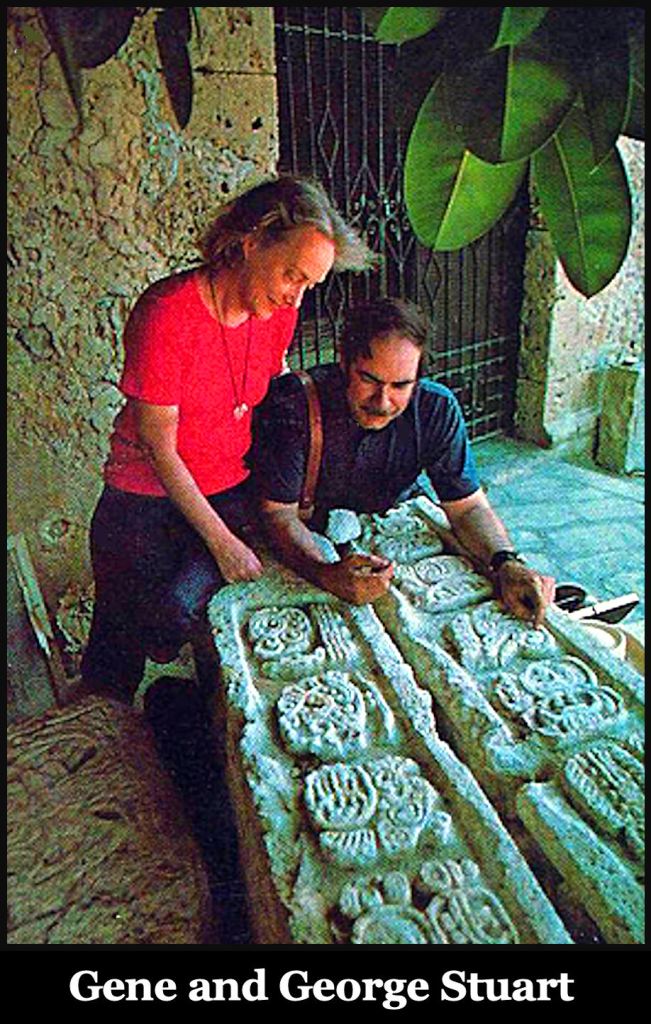
Would you believe that Gene’s first teaching job was in Cartersville High School? She lived near Etowah Mounds. That soon stoked her desire to become an archaeologist so she entered the anthropology program under Dr. Arthur Kelly. Even though George Stuart worked under Kelly as a teenager, George and Gene did not officially meet until much later, when both were employed by the National Geographic Society.
Etowah I Period: Over the years, Dr. Kelly began seeing a pattern. There was a massive immigration of people into northern Georgia around 1000 AD from somewhere to the south. Their new towns were in river flood plains, suitable for Indian corn cultivation, and almost equally spaced. They only built modest, truncated pyramidal mounds like the Talula Mound. Soon after their arrival, their pottery and artifacts synchronized to be like those at Etowah Mounds during its 990 AD to 1200 AD occupation.
Etowah II Period: Beginning around 1250 AD, when the Etowah Mound town site was reoccupied, the population in the mountain valleys began dropping precipitously. Many towns were ultimately abandoned. Others were barely hamlets. In contrast, the large fortified towns on Tugaloo Island in Northeast Georgia and at the Etowah site in Northwest Georgia, exploded in population. Kelly didn’t know this, but several large towns on the Oconaluftee, Tuckasegee and Hiwassee River in North Carolina and Tennessee also expanded rapidly.
Dr. Kelly could never determine where the influx of culturally advanced people came from around 1000 AD or where they went around 1250 to 1300 AD. There was no known advanced, agricultural people in Florida at that time and also no known sudden drop elsewhere in the Southeast at that timepoint.
Etowah III Period: Around 1375 AD, Etowah Mounds was temporarily abandoned. Immediately, the population of the other towns in Northern Georgia began going upward again . . . but never reached the density of the Etowah I Period. They seemed to have the extremely tall skeletons and cultural traits of the branches of the Creeks in the Tennessee River Valley. During the late 1500s there was a steady population drop, but not nearly as stark as the 1250 AD drop. Today, archaeologists label the period from 1400 AD to 1600 AD as the Early Lamar Period
Etowah IV Period: This is today called the Late Lamar Period or (Proto-Creeks). It is characterized by an increasing abundance of European goods. Kaushe Creeks (Upper Creeks or Coosa Creeks) continued to occupy the region north of the Blue Ridge Mountains. Their principal fortified town remained at the confluence of the Nottely River and Coosa Creek until 1785, when the land became part of the Cherokee Nation, but their descendants still live in Union and Fannin Counties, GA today. They look very different than Cherokees . . . having extremely tall, slim skeletons and small, deep-set eyes like raptors.
There was another precipitous drop in population and numbers of towns around 1700. This was probably as a result of the Great Appalachian Smallpox Plague in 1696. While guiding the remodeling of the Etowah Museum in the early 1990s, University of Georgia faculty members erased the existence of the Etowah IV occupation. They were trying to create the myth of the Cherokees “capturing” Etowah around 1585 AD.
In 1818, Yale Professor Elias Cornelius studied the Etowah Site. He found the oldest trees to be about 100 years old. He also determined that the Cherokees never lived at Etowah Mounds and didn’t even arrive nearby until around 1795.
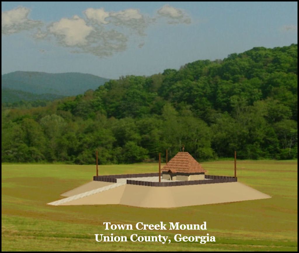
This occupation was defined by the appearance of the large houses on the plaza of Mound A in Etowah. The elite of the Apalache Kingdom lived in such houses, while the commoners lived in rectangular, Mesoamerican style houses. The elite lived in separate towns than the commoners. The Apalachete (Highland Apalache) were called Apalachicola by the Spanish and Conchaqui by the French.
One by one, Apalachete towns in Northwest Georgia began moving southward after 1650, initially settling on the Chattahoochee River and then the Apalachicola River. French maps show some Apalachicola living along the Etowah River until the end of the French and Indian War. At that time, most of the remaining Apalachete (Apalachicola) towns, except Uhale (Euharlee) moved southward to the region around Pensacola Bay. For example, Uthkaluga (as Oothcalooga Creek in Gilmer County, GA) moved to near Pensacola and was visited by William Bartram in 1776.
At this point, I only knew that the highly respected archaeological work of Dr. Arthur Kelly, had been ignored by the generation of professors, who followed him . . . led by Charles Hudson. I did not know how to explain the massive immigration into the Southeast, since Kelly himself mentioned that these people did not seem to come from Florida. More hints to the answer were to soon come as I explored the region.

Hi Richard, This is certainly some in depth post which I thoroughly enjoyed reading. You certainly are an expert at your research. I will need to read this a few times in order to keep up with the names of those different tribes. I fully appreciate your disgust with those that do NOT record things that should be recorded. Have a good day.
LikeLiked by 1 person