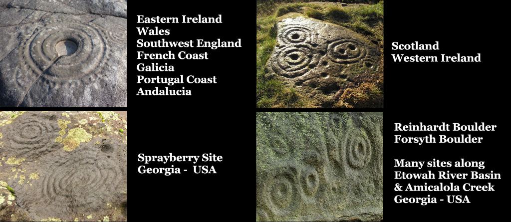
Any petroglyph that you can see in Ireland, Scotland, Denmark, Sweden and Norway, you can also find in at least one river valley in northern Georgia, but not elsewhere in the Americas. A few of the Georgia glyphs are found at two sites in the Southwest . . . Petersborough, Ontario and in a canyon near Tepoztlan, Morelos in Mexico.
Part 2 – The peopling of eastern North America
by Richard L. Thornton, Architect and City Planner
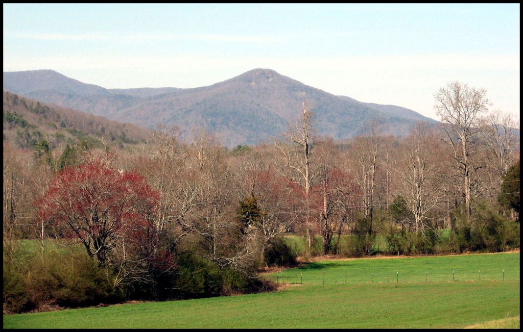
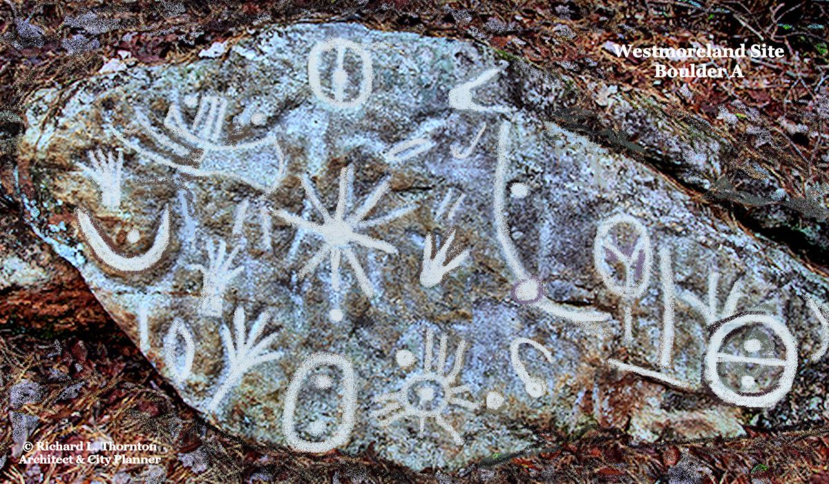
The Westmoreland Petroglyphs, at the top of this page, are on the slopes of Chimney Mountain (above) which is a periodically active gas volcano, about seven miles (11.3 km) north of my house. However, around 1700 AD, the mountain exploded violently, shooting lava bombs and pumice at least as far as my property on Alec Mountain . . . then partially collapsed. At that point, the capital of the Apalache (Creek) Confederacy was moved southward to Ocmulgee Mounds.
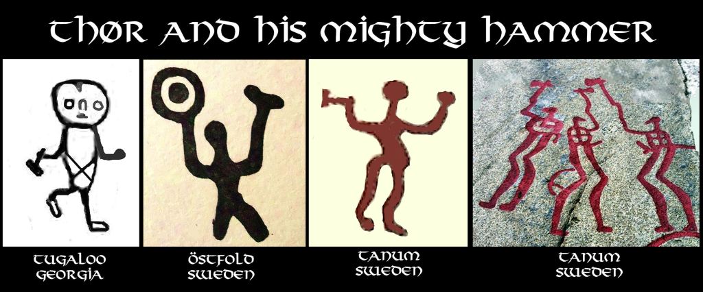
Note the ship with a sail on the upper left hand corner of this boulder!

It has been a mystery that puzzled me throughout my professional career. On June 3rd, I graduated from Georgia Tech. Early on the morning of June 4th, I boarded a Delta flight to New York, then a British Airways Boeing 787 flight to London then a SAS flight to Copenhagen then a bus to Tuborghavn then a large ferry to Landskrona, Sweden. On the morning of June 7, I boarded a tugboat, modified to be a ferry, for the voyage to Ven Island. It was like going through a stargate. That morning, I beheld the Scandinavian Bronze Age.
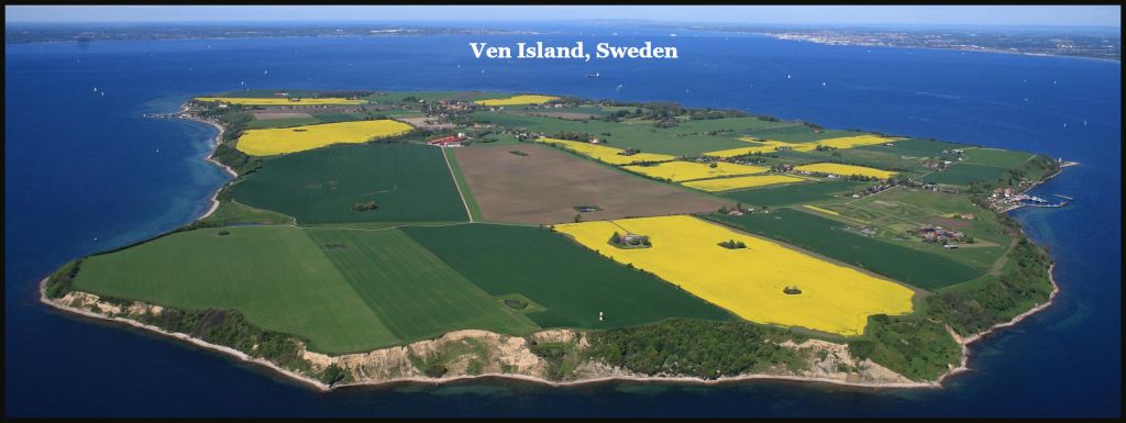
My boss, Stadsarkitekt Gunnar Lydh, wanted me to see the project site, where I would be working as soon as possible. It was located on one of Sweden’s most historic islands. Ven’s soil contained the levels of human occupation, going back to the Ice Age. Ven’s name came from the Gamla Norsk word for grass or pasture. It is also the root word of Vinland. Than name has nothing to do with grapes. During Neolithic, Copper Age, Bronze Age and Iron Age times, the island had been used for the raising and marketing of cattle.
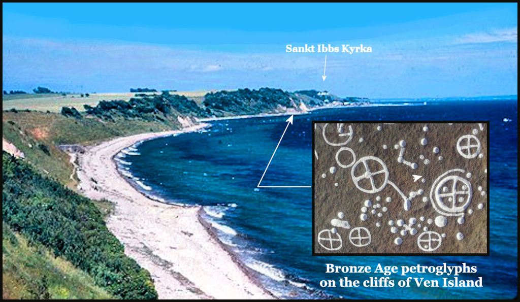
The Ven Ferry landed us in the harbor of Backvicken, a village that probably dated back to at least the Neolithic Period. (9,000 BC – 2,000 BC). From there, we climbed up the cliff of the deposits left by the last ice cap, then across the pastures to the general area of my project. The farm houses and barns in that part of the island dated from the Late Medieval Period or perhaps earlier.

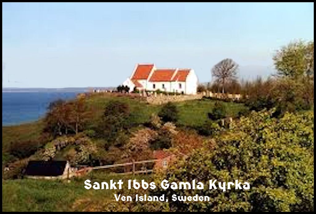
Our first destination was Sankt Ibbs Kyrka, one of the earliest Christian churches in Scandinavia. Kyrka is pronounced like “shirka.” It replaced a wooden pagan temple. Nearby are stone shrines from the Neolithic Period and Bronze Age. Those shrines were once surrounded by several acres of ornamental ponds, built during the Late Stone Age in abstract patterns. Most of these ponds were invisible to the eye, now. What remained now were some small ponds near the pagan temple site, that were used to make human, animal and inanimate object sacrifices.

The hike was surrealistic. I was stepping back thousands of years in time after living on a university campus next to Downtown Atlanta for five years.
My project was to design a bil-fri by (pedestrian village) somewhere in the general vicinity of the church, but Gunnar wanted me to understand that we were on terrain, saturated with the heritage of Sweden. I was not to harm or get uncomfortably close to these historic landmarks. That included the petroglyphs. We clambered down the cliff. At the bottom, were large boulders, with symbols carved on them exactly like I had seen at the Etowah Mounds Museum in Cartersville, GA. I told Gunnar that these were Creek and Uchee sacred symbols. He laughed at me.
For the remainder of the summer, Britt, my official Swedish girlfriend, and I wandered about southern Sweden on weekends. I saw hundreds of burial mounds and numerous petroglyph sites. Most of the petroglyphs were similar to those in the vicinity of Landskrona and Ven Island. However, on the Baltic Coast of Sweden, I saw petroglyphs that looked like those at Track Rock Gap.
Other locations, in particular along the Oresund and North Sea coast line, I saw a mixture of the southern Swedish and Baltic Seacoast petroglyphs, but not all of them. I didn’t see either burial mounds or petroglyphs in northern Sweden and northern Norway. Photos that show “Danish petroglyphs” are typically from Bornholm Island, which is off the coast of SE Sweden.
No one else is giving them any thought
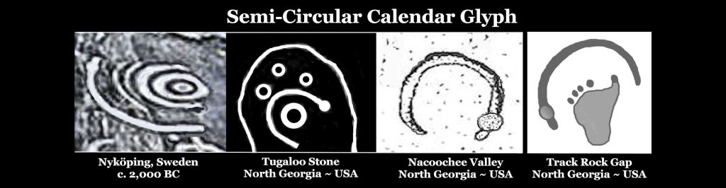
For decades I pondered why I saw Creek sacred symbols, used as a decorative motif on the Etowah Mounds Museum were also on boulders in southern Sweden. I also wondered why the symbols on the Track Rock Petroglyphs in Georgia were on boulders along the Baltic Coast of Sweden. I didn’t know this in 1972, but the Nyköping Petroglyphs on the Baltic Coast were later dated to c. 2000 BC. They are the oldest petroglyphs in Scandinavia!
Then in the period between 2012 and 2017, I realized that Georgia archaeologists were ignoring both the petroglyphs and the many stone ruins in northern Georgia. On the few occasions, when they did pretend to study a few of the petroglyphs, their interpretations were hilarious. They obviously did not have adequate educational experiences to appreciate what they were looking at.

Tugaloo Stone – A University of Georgia Anthropology professor interpreted these as “an early form of Cherokee writing.” The quarried stone contains Swedish Bronze Age astronomic symbols plus several Bronze Age European ships. The Cherokees did not own the land south of the Tallulah River until after the American Revolution and even then, the Tugaloo Stone was found on land ceded by the Creek Indians to Georgia in 1784. The stone was discovered in 1795.

Track Rock Petroglyphs – The Georgia Council of Professional Archaeologists have endorsed a US Forest Service Report, which interprets the six boulders at Track Rock Gap as being “merely graffiti by bored Cherokee hunters.” Track Rock Gap was in the territory of the Creek Confederacy until 1785, while its symbols obviously long predate the creation of the Creek Confederacy.
Comparison of petroglyphs on both sides of the Atlantic


Now YOU know!

Hello ~ Your intuition is not wrong. I have been mapping CnR markings and have verified them found on 94% of the planet’s landmass, almost every country, and 25 US States. The story they tell is incredible. If you are interested my research is available here: I Can Read The Stones (Deciphering Cup and Ring Motifs around the World) – ICanReadTheStones
Kind Regards,
LikeLike