
Two centuries ago, there were thousands of ancient fieldstone cairns, retaining walls, building walls and circles in northern Georgia. The circles varied from 6 to 50 feet (2-15 m) in diameter and seemed to be randomly scattered across the hilly to mountainous landscape. In addition, many of the prominent mountain peaks had much larger and more refined stone ovals on their crests. In particular, the isolated mountains in the Atlanta Metro Area were likely to be crowned with stone ovals. They apparently were sophisticated astronomical observatories.
According to pioneer archaeologist, Charles C. Jones, Jr., most of the stone structures in the Piedmont were quickly converted into chimneys and foundations by early white settlers. Because they were originally so endemic, several hundred stone cairns remain in both the Piedmont and the mountainous region, while there still exist several dozen stone circles in the Northeast Georgia Mountains. Between 1920 and 1950, almost all of the mountaintop stone ovals were crushed into gravel by the Georgia State Highway Department to build roads. The Alec Mountain is possibly the last remaining, fully intact stone oval. However, a LIDAR scan has discovered another large stone oval about 7 miles to the north of Alec Mountain. It may also be intact.
The branches of the Creek Confederacy, who formerly occupied all of this region, acknowledged that their ancestors had built the earthen mounds, agricultural terrace retaining walls and building walls. However, the cairns, circles and ovals were old, when they first arrived in the region. They did not know who constructed them. Meanwhile, white settlers speculated that all of these stone structures were built by the Spanish, Lost Tribes of Israel, Christian Roman refugees or Welsh settlers led by Prince Madoc.
Part 12 of the Mesolithic Period in North America
by Richard L. Thornton, Architect and City Planner
Virtual Reality Architectural Rendering Above: Once the leaves are down, I can see the location of Alec Mountain Stone Oval from my rear bedroom window, yet it took me two years to specifically locate the stone structure and visit it. The structure is identical in every detail to stone ovals constructed on mountain crests in the eastern Scottish Highlands around 3000 BC. That region also contains petroglyphs identical to those in southwestern Ireland and the Etowah River Basin in the State of Georgia, USA.

Ladds Mountain Observatory was the largest stone oval. It was constructed out of limestone field stones. The site is about 2.5 miles (4 km) northwest of Etowah Mounds, on the edge of the City of Cartersville, GA. Archaeologist Robert Wauchope wrote that in 1939, it was about “220 paces by 200 paces” or about 660 feet x 600 feet = 201 m x 183 m), The structure was mostly demolished a few years later in order to make gravel for a nearby state highway.
The Sweetwater Creek Stone Oval was on a hilltop over-looking the Chattahoochee River, near Six Flags Over Georgia. It was almost exactly the same dimensions as the Alec Mountain Stone Oval. Unlike Alec Mountain, Sweetwater’s periphery was defined by tablet-like boulders and had a carved stone stela in its center. The stela is on display at the Sweetwater Creek State Park Visitors Center.
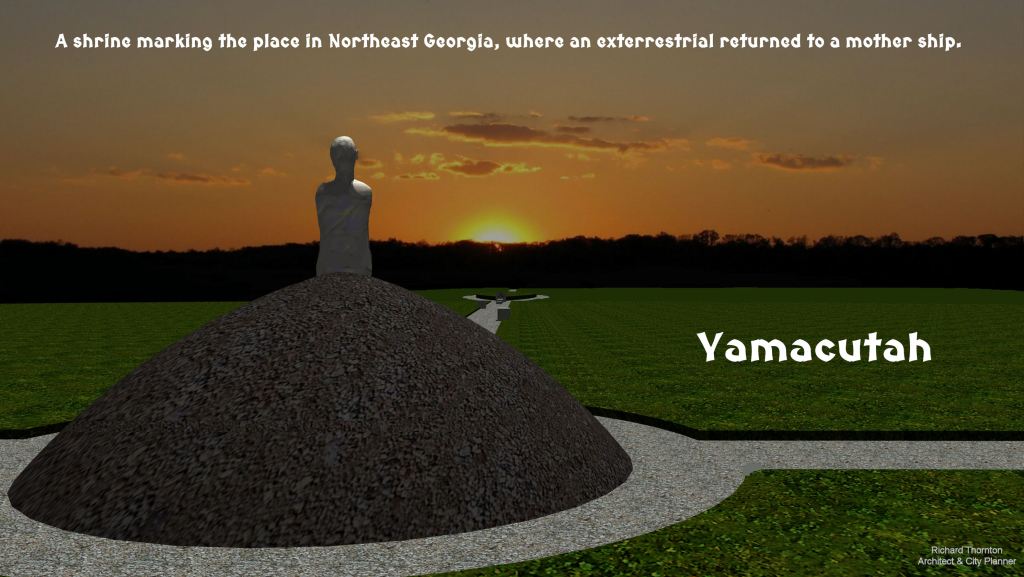
The Yamacutah Shrine in Jackson County, GA (NE Metro Atlanta) was not a stone enclosure, but was oval shaped. The periphery and radians of the shrine were marked with engraved, quarried stones. In 1785, it was precisely measured and sketched by two Land Surveyors on their way to lay out the new University of Georgia. At the center was a small mound that supported a carved stone statue of a humanoid, looking up into the sky. While staying with the Apalache Creeks, he had taught them advanced mathematics, a writing system, a universal religion and traditions that would ensure people living in harmony with their fellow citizens and with nature.

The Yamacutah Shrine was roughly four times the size of the Alec Mountain Stone Oval.

A virtual reality image drawing of the carved stones, based on sketches and verbal descriptions by the surveyors.

Dr. Phillip E. Smith of the Peabody Museum (Harvard University) excavated the Alec Mountain Stone Oval in 1951. He did not find any artifacts in the soil. Although the slot is aligned with the Winter Solstice Sunset, which was the beginning of the Maya New Year, I have not seen any structure in Mexico or other parts of the United States, which is similar architecture.
The Alec Mountain Stone Oval
Latitude: 34.39702 Longitude: -83.3606019
County/State: Habersham – Georgia
Elevation: 610 meters – 2001 feet above sea level
Access: Posted private property – not open to the public
The center point of the Alec Mountain Stone Circle is the exact same elevation (2001 feet – 610m) as the Westmoreland Petroglyphs on Chimney Mountain, which the Apalache Research Foundation team studied on the weekend of March 30, 2019. There are numerous, but much smaller stone rings scattered along the upper slopes of the mountain, including one in the back of my property, plus a rectangular stone monolith.
Professional Investigations: Charles C. Jones, Jr. (1859), Cyrus Thomas of the Smithsonian Institute (1886), George A. Heye of the Heye Foundation (1915), Robert Wauchope of the University of Georgia (1939), Phillip E. Smith of Harvard University (1951) and Arthur Kelly of the University of Georgia (1953). All of these archaeologists were puzzled by the Alec Mountain Stone Oval and did not know of any similar structure in the United States, other than the Ladds Mountain Observatory.

Stone masonry detail photos – Because of the dense growth of trees in and around the Alec Mountain Stone Oval, it is impossible to obtain a photo or video of the entire structure. Most of the stones are cream-colored rhyolite, but some are dark gray basalt, white pumice or black scoria (lava bombs).
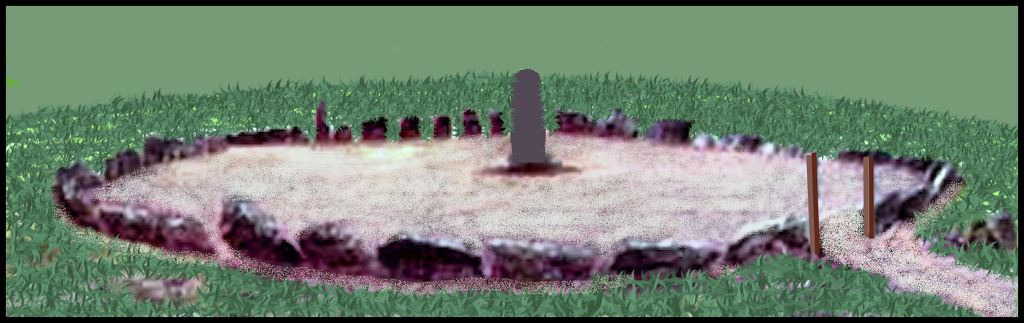
The Alec Mountain Stone Circle is an oval stone masonry structure, composed of carefully laid, volcanic rocks . . . not a ring of boulders as described in a sketch by one 20th century archaeological journal. It may in fact, had a terraced, stone walled plaza . . . as it is built on approximately a 10 % slope. A dense bed of dead leaves concealed the original grade.
Its long axis is 100 feet (30.5 m) long. Its short axis is 89 feet (27 m) long. There is an opening in the wall and an access ramp that aligns with the Amos Creek Burial Mound and the Winter Solstice Sunset. On the uppermost terrace of the structure are stone ruins of a temple or shrine, plus two rectangular altars.
This an extraordinary example of astronomical architecture that has been completely forgotten by the archaeological profession, since Dr. Arthur Kelly measured and “poked around” the Alec Mountain Stone Circle in the early 1950s. At the time, the stone circle was in almost perfect condition. It was a major tourist attraction in Northeast Georgia, which was maintained by a local Boy Scout troop. There was a public parking lot on Alec Mountain Road and a hiking trail, connecting the parking lot with the stone structure. Even today, the structure is so intact, it really cannot be labeled “ruins.”
In the late 1970, the Habersham County Roads Department reconstructed Alec Mountain Road. In the process, they destroyed the parking lot and the sign. Neither were replaced. For unknown reasons, the Boy Scout troop stopped maintaining the archaeological zone, so it began growing up in trees. Unable to find access to the hiking trail, tourists stopped visiting the stone ring. Today, it is generally unknown to residents of Northeast Georgia . . . even people living on Alec Mountain Road. It has never received recognition or protection from the State of Georgia, the National Park Service or the National Register of Historic Places.

Who built the Alec Mountain Stone Oval?
Mesoamericans?
Eighteenth century Creek leaders stated that their ancestors did not build the stone cairns, circles or ovals. Indeed, there are no stone circles or ovals inside or adjacent to any ancestral Creek towns. There are stone cairns inside Itsate Creek agricultural terrace complexes. In fact, most of the terrace complexes include cairn cemeteries. The Creeks occasionally utilized some of the large stone ovals on mountain crests, but had no clue what purpose the much more numerous, but much smaller stone circles once had.
In my extensive travels to Indigenous American archaeological sites in Mexico and the Southwestern United States, I have never seen any structure that remotely resembles the Alec Stone Oval. The Puuc Mayas in Campeche and southern Yucatan did build oval pyramids, but I never saw an oval, mountaintop, stone-walled shrine in Mexico.
Small stone circle near my house on the east end of the Nacoochee Valley.

A Neolithic Period stone circle near Ballinoe, Ireland
Almost identical structures in Scotland and Ireland
Stone circles and cairns, believed to date from the Late Neolithic Period and Copper Age (6,000-1,500 BC) are endemic in Ireland and the less mountainous parts of Scotland. Stone ovals, identical in every detail to the one on Alec Mountain are primarily found in the eastern Scottish Mountains, in particular near the city of Dundee.
Petroglyphs identical to those in the Etowah River Basin of Georgia can also be found near Dundee. However, the petroglyphs near Alec Mountain are identical to those in Late Neolithic and Bronze Age southern Sweden, not those in Ireland and Scotland.

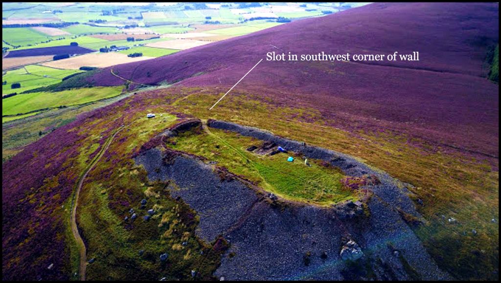
This restored stone oval near Dun Heath, Scotland dates from around 3,000 BC. It is about the same length as the one at Alec Mountain, Georgia, but not quite as wide. Note that like the one at Alec Mountain, it was built on about a 10% slope and appears to be terraced. also like Alec Mountain, there is a rectangular shrine on the northeastern end of the oval. The southwestern corner originally had a slot in it, but Picts, who later occupied the site, filled in the slot to utilize it as a fort.
Tap O’ North is Scotland’s largest Stone Oval. It dates from around 3,000 BC and is about the same size as the Ladds Mountain Observatory.
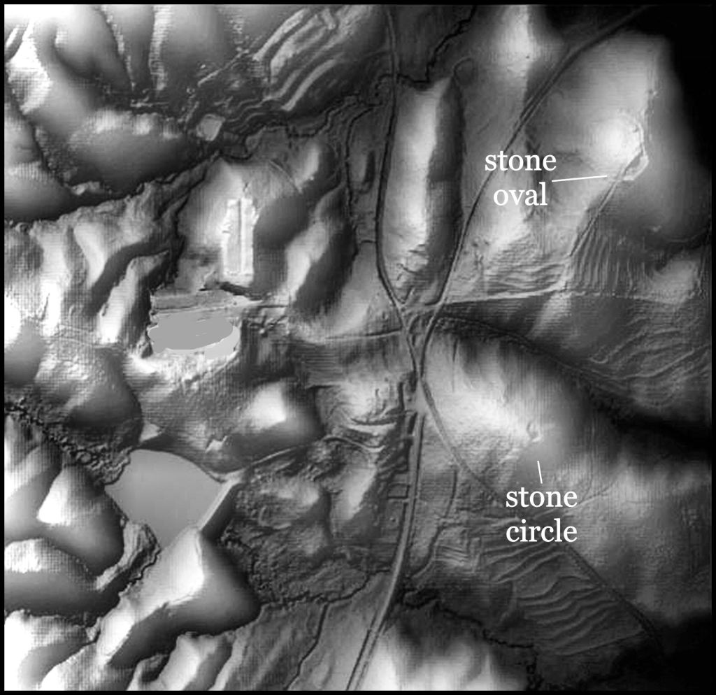
Using LIDAR, I recently discovered a stone circle and stone oval east of Batesville, GA. They are seven miles (11.3 km) due north of the Alec Mountain Stone Oval. The stone oval has a similar footprint to Scottish Highland stone ovals. So far, I have not gotten a response from the property owners, concerning my request to measure and study these structures. Note the numerous ancient agricultural terraces, beneath the forest canopy that LIDAR revealed.
Why academicians ignore these stone structures
Hyping England’s history
Within a few months of Queen Elizabeth the First’s coronation, the government of the Spanish Empire began plans to exterminate her and England’s Protestant clergy then replace her with a Roman Catholic monarchy. Being grossly outweighed militarily, Elizabeth initially opted for asymmetrical warfare. Several of her noblemen, such as Sir Francis Drake, essentially became pirates, while at the same time exploring the coasts of the Americas. They often collaborated their raids with Protestant and Sephardic Jewish pirates from Scotland, France and the Netherlands. A portion of pirated Spanish gold and silver went into the war chests of those respective countries.
There was also a propaganda campaign underway to challenge Spain’s claim to all of the Americas. England’s most respected scholars were charged with finding proof that someone from the British Isles had discovered and colonized the Americas before Christopher Columbus. Their research was then published in Sir Richard Hakluyt’s book, Divers Voyages Touching the Discoverie of America (1582) and The Principal Navigations, Voyages, Traffiques and Discoveries of the English Nation.
Scholars immediately claimed that fishermen and traders from Hull and Bristol, England, Belfast, Ireland and Bretagne, France were fishing off the coast of Newfoundland at least by 1480. They were said to have established permanent fishing base camps on several islands off the coast of Newfoundland, which they called the Island of Brasil. These statements were possibly true, but have not been yet been proven by archaeologists.
Prince Madoc of Wales: The first mention of the Prince Madoc legend appears in a sixteenth-century manuscript by Welsh antiquarian and politician Humphrey Llwyd and was popularized after it was reproduced in historian David Powel’s 1584 history of Wales. Modoc was said to be a Welsh prince, who explored North America and founded a colony of Welshmen.
Hakluyt then dug up vague stories of an Irish priest, named Brenden, founding a colony in the 500s or 600s AD and added them to the Prince Madoc story. He elaborated the stories and published them as historical facts.
Nineteenth century Americans took up that baton and ran with it. Hakluyt’s “enhanced” history was converted into was were essentially novels. The people of Mobile, Alabama decided that Prince Madoc’s fleet landed there. The version of the legend centering on the Mobile connection was popularized by the relentlessly determined preservationist and unreliable amateur historian Hatchett Chandler and the equally unreliable amateur historian Zella Armstrong of Chattanooga in the book Who Discovered America? The Amazing Story of Madoc (1950). In 1953, Chandler persuaded Mobile’s Virginia Cavalier Chapter of the Daughters of the American Revolution to erect a marker commemorating Madoc’s alleged landing at Fort Morgan in Mobile Bay. Throughout the 19th and 20th centuries, several communities in the eastern United States decided that stone ruins nearby were the vestiges of a castle built by Prince Madoc.
Roman colonists: A 16th Century Scholar Marineo Siculo first claimed that the Americas were discovered not by Columbus and the Spaniards, but rather by ancient Romans. He cited the discovery of a Roman coin bearing the image of Augustus in a gold mine in Darien, Panama. Hakluyt altered the theory to state that Romanized Britains fled their island to settle in America, after it was invaded by Saxons. Implausible as the idea might seem, hundreds of Roman imperial coins have been found in several locations in Canada, the United States, Mexico, Venezuela and Brazil. Most of these were in caches, buried underground or hidden in caves.
In the previous article of this series, I described how scholars for 500 years ignored the description of the Irish colony of Duhare near Savannah, because the original Spanish authors said that the people of Duhare raised dairy deer. In fact , Irishmen did develop a dairy deer and for perhaps 3000 years, it was their only source for milk, butter and cheese.
It’s the same type problem with evidence of movements of people back and forth between the British Isles and North America. Because 16th, 17th, 18th, 19th and 20th century authors hyped folklore into “historical facts,” contemporary academicians are contemptuous of any suggestions of an archaeological site being linked to Pre-Columbian colonists from Europe.
Aside from the stark physical evidence of the same petroglyphs and stone structures on both sides of the Atlantic, we have this astonishing fact recently uncovered by long time Americas Revealed supporter, Ed Reilly. In 1477, Christopher Columbus traveled to Ireland to obtain maps of the North Atlantic Ocean and Witmannsland. He also accessed various monastic journals. In 1492, Columbus intentionally hired an Irishman as one of the pilots in the voyage to what he thought would be Asia. Obviously, Columbus knew something that has been forgotten in modern history books.

Alec Mountain Gap, looking toward Yonah Mountain
The Truth is out there somewhere!

Excellent
Sent from my iPad
>
LikeLiked by 2 people
These stone ovals are very interesting Richard and each one has it’s own story. Thanks for sharing.
LikeLiked by 2 people
Ovals mounds and pyramids next to my house in Union county. These sites are virtually unknown to the public and denied by many so called scientist who should know better.
“The pond” = 34.51 03 49 N 83.54 00 00 W
Ancient stone bowl molds = 34.52 01 27 N 83.52 54 45 W
Karin pyramid = 34.52 14 74 N 83.52 43 66 W
Copal (Track rock pyramid and glyphs) 34.52 51 81 N 83.52 12 40 W
Holt Rd pyramid 34.48 26 85 N 83.54 14 03 W
Fort Mtn rock walls artifacts 34.49 10 70 N 83.57 05 10 W
Use GE to view the coordinates above. Place a pin marker at each and then look at the water ways, creeks and rivers.
Note the directional layout of these ancient ruins start from Copal and end at Ft Mtn. Hint, they line up in direction of the winter solstice sun set. All of these sites are in archeological context. Many artifacts and features have been collected dated and cataloged in and around these sites.
None of these sites are secret so posting the coords would not impose property rights violations. If you read this and are interested in visiting the sites please respect private property. Coordination of group or professional visits might be arranged through the Notley River Basin Archeology Group. charlieharner@comcast.net
What I have left off of above list would create a problem for local land owners had I mentioned them. Not on list above would astound you. The probable sites of additional pyramids, caves, mounds, trades routes, mines and others is breath taking.
Where are our Anthropologist?
Richard, thank you so much for guidance that has enriched my interest in human history. This is world class heritage hidden in the mountains of North GA.
LikeLiked by 3 people