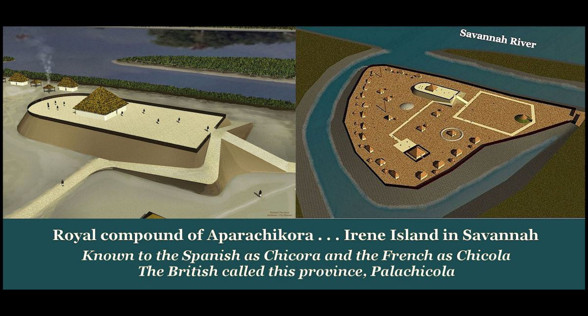
The large, ancient town of Aparachikora* was located, where Savannah, GA sits today. It once ruled a province or confederacy, which probably stretched from St. Marys Sound, GA to Winyah Bay, SC. Structures as old as 3545 BC have been found in Savannah. The acropolis for this large town was on Irene Island, which is now part of the Port of Savannah. According to Creek Indian leaders in the early 1700s, Aparachikora was the first capital of the Creek Confederacy.
In this article, inaccurate speculations made by 19th century academicians in South Carolina and ignored, accurate research in Europe are unraveled to reveal a fascinating connection between Ireland and Southeastern North America. It is highly probable that Irish religious refugees sailed to the South Atlantic coast during the Early Medieval Period. They intermarried with their Uchee, Creek and Chickasaw neighbors then ultimately joined the Creek Confederacy!
- The L’s were rolled so “hard” in most Creek dialects that they are typically written as R’s in English. Thus, the equivalent in phonetic English would Apalachikola.
Part 16b of the Mesolithic Period in Eastern North America
by Richard L. Thornton, Architect and City Planner

Academicians not doing their homework
Spanish slave traders, Francisco Gordillo and Pedro de Quejo , stated that Duhare was near a large, powerful province that they pronounced, Chicora. For unknown reasons, South Carolina academicians and historians, very soon after the American Revolution, decided that Chicora was located near either Charleston Bay or 61 miles (98 km) to the north on Winyah Bay. No one realized that Chicora was a European abbreviation for a longer Native American word.
Following a tradition that continues to today, subsequent generations of historians and then anthropologists parroted what earlier authority figures in academia speculated, rather than starting afresh with eyewitness accounts and more sophisticated research techniques. The name Chicora became ingrained with South Carolina history, even though no one actually knew where its capital was located. Repeated efforts by archaeologists could not identify the site of a large, sophisticated town near the South Carolina coast.
So . . . today in northeastern South Carolina, we have a town, several public schools, a Presbyterian Synod, a college, several regional state agencies, a Boy Scout Area Council, several churches, numerous streets, a shopping mall, several subdivisions and a legion of civic associations named Chicora. In fact, it is one of most common proper nouns in northeastern South Carolina. Undoubtedly, there have even been some babies name Chicora.
There are TWO state-recognized Chicora Indian tribes near Myrtle Beach, SC. Both were created in the late 20th century. Based on the advice of South Carolina anthropology professors they are called the Chicora-Dakota Siouan Indian Nation (near Andrews) and the Chicora-Waccamaw Indian People (near Conway). The Chicora-Dakota Siouan Nation have given themselves Lakota Sioux names and taught themselves Western Plains cultural traditions. The Waccamaw tend to emulate the customs of the federally-recognized Catawba Nation, which is located in northeastern South Carolina. No one in South Carolina seems to know that the Spanish word, Chicora, was derived from Panoan words . . . from eastern Peru.
No map of the Province of South Carolina contains a tribe named Chicora. However, the Chicora tribal websites tells us that the Chicora were traditionally a coastal tribe living near Pawleys Island, South Carolina. They grew corn, tobacco and beans in their gardens and domesticated animals like deer and chickens.

This Dutch map from 1570 showed the Province of Chicora to include all the land between the Altamaha (May) River and Port Royal Sound, South Carolina. In truth, Native Americans probably did not consider the entire region, Apalachicora, but garnered their ethnic identity from individual tribal territories, the size of a typical county, today.
Linguistics
Chicora is the abbreviation of Apalachikora, the Panoan name of a large town where Savannah, GA is today. The Panoans are a large groups indigenous tribes in eastern Peru and the headwaters region of the Amazon River Basin. However, virtually no academicians know this. The word means “Descendants of people from the ocean (or Upper Amazon Basin).” Pará is a large state in northwestern Brazil. By the time Savannah was settled in 1734, Apalachikora had moved upstream about 35 miles. The new town was labeled Palachicola or Palachicora on British maps.
However, according Georgia Provincial Secretary, Thomas Christie, the Uchees and Creeks still remembered the original Apalachicora being visited by friendly Frenchmen, led by a man with red hair and red beard. [Christie (1735) The Creek Migration Legends*] That was probably Jean Ribault in 1562, but could have been Captain René de Laudonnière in 1565. Both men visited Apalachicora.
*The wooden chest, where I found the so-called “Lost Creek Migration Legend” (The Kaushete Migration Legend) in 2015 actually contained many other documents either written by Thomas Christie, including migration legends for the Uchee (who stated that they crossed the Atlantic by boat) and several other tribal members of the Creek Confederacy. They all stated that they either crossed the Great Water from southern Mexico or migrated by land from southern Mexico. Not in the chest was the Apalache Migration Legend (the real Apalache in NE Georgia). Their ancestors crossed the Great Water from South America.
Oklahoma Muskogee-Creeks think that the Kaushete Migration Legend is the Muskogee-speakers migration legend. It is not! There is no Muskogee Migration per se. However, both Tamachichi (Tomochichi in English) and Chikili, the High King of the Creek Confederacy, stated that the first capital of the Creek Confederacy was located, where the city of Savanah was being developed. Both stated that the first High King was buried in a mound west of Savannah. His mound was noted as “Tomb of the Indian King” on the first map of Savannah, drawn by General James Edward Oglethorpe.
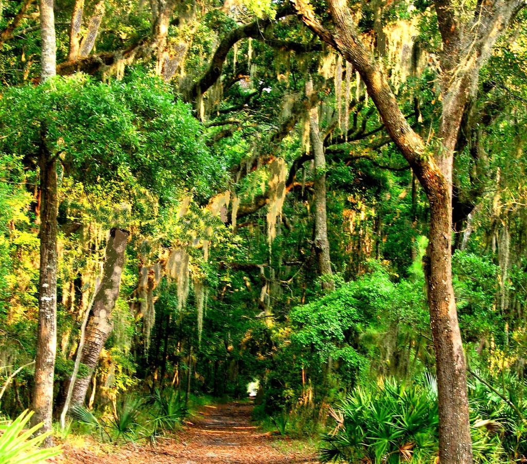
Trail on Sapelo Island, Georgia
French Archives
In his memoirs, Captain de Laudonnière provided the latitude and longitude of the mouth of the river, up which French expeditions twice visited Chiquola. This information exactly matches the entrance to the Savannah River. The capital was 16 miles (7 French leagues) upstream from the ocean. De Laudonnière specifically stated that Chiquola was the same place that the Spaniards call Chicora. [Bennett (2000) Three Voyages, pp. 29-30]
Peter Martyr placed Chicora and Duhare beside each other. For unknown reasons, twentieth century academicians placed the province of Chicora in a region around Georgetown, SC or about 61 miles NORTH of Charleston, whereas both French and Spanish eyewitness accounts placed Chicora south of the Port Royal Bay in the vicinity of Savannah, GA. That’s about 167 miles south of Georgetown, SC.
Also, for unknown reasons, Georgia academicians took the false assumptions of the South Carolina academicians as fact. Chicora is briefly mentioned in the Georgia History textbook, but placed in South Carolina. Duhare is not mentioned at all.
Spanish Archives
The Spanish provincial capital of Santa Elena was founded on Parris Island in Port Royal Sound, SC in 1567. According to a letter sent by Governor Pedro Menendez to the King of Spain, the Spanish dispatched two expeditions to attack Chicora about 35 miles to the south. That is the nautical distance from Parris Island, SC to Savannah, GA. The Spanish were soundly defeated, but the townsite was soon abandoned and moved upstream.
Because of the hostility and sheer numbers of the Kingdom of Apalache (Proto-Creeks) in what is now northern and Central Georgia, the Spanish only rarely entered the interior of the region. They were told that they would be killed, if they traveled farther north than Tama . . . which was near the confluence of the Oconee and Ocmulgee River.
First History of Georgia
In 1847, the History of Georgia was published by William Bacon Stevens, just before he moved back north and became an Episcopalian vicar in Philadelphia. The book opens with the statement, “The early history of Georgia is obscure and unsatisfactory. Its Ante-Columbian period reaches backward five hundred years before the voyage of the Genoese navigator, and embraces, in its annuals, the fables and traditions of the wild and sea-faring Northmen.”
The second paragraph mentions the settlement in Georgia and the southern tip of South Carolina by Irish refugees. It refers to the mention of Whitmannsland (White Man’s Land) or Great Ireland on certain maps and in certain chronicles then references the research of Danish historian Karl Kristian Rafn. Later in the book, Stevens mentioned briefly that early settlers in Georgia and South Carolina encountered light skinned Creek Indians, who spoke a dialect of Irish.
Karl Kristian Rafn -19th century Danish scholar
Rafn’s thorough research of Icelandic literature was astonishing, but has been generally ignored in the 21st century by North American academicians. In his book, Antiquitates Americanae, Rafn documented numerous voyages of Scandinavians to Vinland and Whitmannsland in the 1000s and early 1100s, which were followed by Norse and Irish colonists in the late 1100s.
Eugene Beauvois of France
Discovery of some forgotten medieval manuscripts in France during the 1890s renewed the interest of French scholars in North America’s Pre-Hispanic history. The information somehow never reached the western shores of the Atlantic.
In 1904 French historian, Eugène Beauvois, wrote “La Grande-Irlande ou Pays des Blancs Précolombiens du Nouveau-Monde” (Great Ireland or the Pre-Columbian White Nation in the New World.) It was published in the French Journal de la Société des Américanistes, but never published in the United States or Canada.
Beauvois had found manuscripts in French monasteries that collaborated with the information extracted by Carl Rafn from Icelandic scripts. However, the French sources went a step further. They located the Irish colonies on the South Atlantic Coast . . . exactly where Francisco Gordillo and Pedro de Quejo encountered the Province of Duhare.
A motive for leaving Ireland
In 1139, the Second Lateran Council declared priestly marriage invalid throughout the entire Catholic Church. Prior to that time, it was common (and considered normal) for Irish, Welsh, Anglo-Saxon, Norse and Scottish priests to marry and have children. After the Norman Invasion of England in 1066 AD, the Norman clergy tried to eliminate married priests in England, but did not have the legal status to do so until the Second Lateran Council.
Anglo-Norman armies invaded Ireland in 1160 AD, but initially only controlled the southeastern corner of the island up to Dublin. Between 1160 and 1190, the Anglo-Normans severely persecuted the Norse around Dublin and Wexford, who were Arian Christians and the Irish in Leinster and Osrey, who adhered to the practices of the Old Gaelic Christian Church and whose traditions included a married clergy and very simple liturgy. The persecution included some priests and bishops being burned at the stake as heretics. So . . . there was a very real incentive for the people of eastern Ireland to risk their lives to cross the Atlantic Ocean.

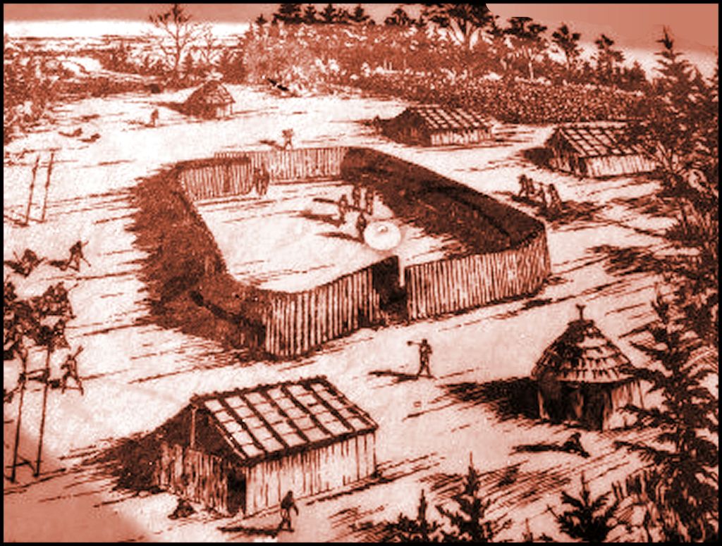
A farmstead on St. Catherines Island, GA around 1500 AD
Fact-checking North American academicians
In the five centuries since the Peter Martyr’s book, scholars in North America have completely discounted Martyr’s description of Duhare because of the detailed description of its deer cheese production. Having spent almost two decades, making commercial goat cheese, I strongly suspected that the people were milking Alpine type dairy goats. I was going to investigate the matter.
The Spanish slave raiders’ description of deer husbandry and cheese making seemed far too accurate to have been made by mariners, who dreamed up a tall yarn. This author started the first state-licensed goat cheese creamery in the United States and the first federally-licensed goat cheese creamery, after moving to Virginia. The story also intrigued me because the personal names of the Duhare sounded Gaelic, even though the Spaniards made no mention of the ethnicity of these people.
Not knowing any Gaelic and only a smattering Early Irish History, I contacted the Irish Consulate in Atlanta. Consul Paul Gleeson directed me to the Cultural Attaché Office of the Republic of Ireland. It was given the details and personal names of this chapter of Martyr’s book.
My first big surprise from conversing with the Irish scholars was that dairy deer were commonplace in Ireland until the Late Middle Ages. Why didn’t any of the scholars, who dissed the story of Duhare, ever talk to their counterparts in Ireland? In the 1000s AD, Norse settlers introduced dairy goats to the eastern edge of Ireland and in the 1200s, English and French monks introduced dairy cattle to Ireland. However, the Osrey (Deer People) held on to the tradition of deer milk cheese longer than anyone else. So, we had a connection. A people known for making deer cheese were the victims of Anglo-Norman persecution in the late 1100s.

This village site on the Swannanoa River near Asheville, was remarkably similar in plan to the descriptions of Duhare villages. The archaeological zone is now considered to be a “Sacred Cherokee Heritage Site,” by North Carolina archaeologists, even though a word like Cherokee only appears in maps of North Carolina after 1717. The Swannanoa Valley was Shawnee territory from 1600 AD to 1763, and never within the boundaries of the Cherokee Nation.
During the 1980s, while I was living near Asheville, NC, there was a very odd archaeological discovery made on the campus of Warren Wilson College near Asheville. What appeared to be a Native American village also contained what was essentially a corral in its central area. The village had a palisade around its exterior made of large timbers, but the inner palisade was constructed of saplings . . . like a fence. The mention by the Spaniards of the dairy deer being contained in the village at night seemed to be related to this corral. This village was abandoned around 1500 AD, only eight years after Columbus’s voyage.
This 18th century Chickasaw village in Northwest Georgia contained a palisaded corral for penning deer that is very similar to the layout of the Warren Wilson College Village. Thus, we have architectural evidence that at least some of the villages of Duhare intermarried into the Chickasaw People.
Conclusion
The evidence is profound that Gaelic and Norse Irish Christians, fleeing persecution by foreign bishops, who were trying to enforce revised Roman Catholic practices on the Celtic Church, fled to North America in the 11th and 12th centuries. According to Icelandic and French monastic archives, Norse mariners provided them the transportation across the Atlantic. Supposedly, they settled south of where the Norse were colonizing, in what is now the Southeastern United States. They called their new home, Mór in Áire (Great Ireland) or DuH’áire. Scandinavians called their colony Står Irland (Great Ireland) or Vitmannsland (White Man’s Land.” During the 1600s, most of the mixed ancestry descendants of these Irish colonists apparently were absorbed into old Kingdom of Apalache in Northeast Georgia, which later evolved into the Creek Indian Confederacy.
The testimonies of two Spanish slave raiders and linguistic evidence cannot be construed as absolute facts until actual Irish village sites are identified along the Eastern Seaboard of North America. This is an identical situation to that of the tradition of Norse settlements on the coasts of New England and the Canadian Maritime Provinces. These traditions were considered to be myths by many historians and archaeologists until Norwegian archaeologists, Helge and Anne Ingstad, unearthed a Viking hamlet on the coast of Newfoundland. The Duhare matter seemed to be in limbo until a similar discovery is made in Georgia or South Carolina.
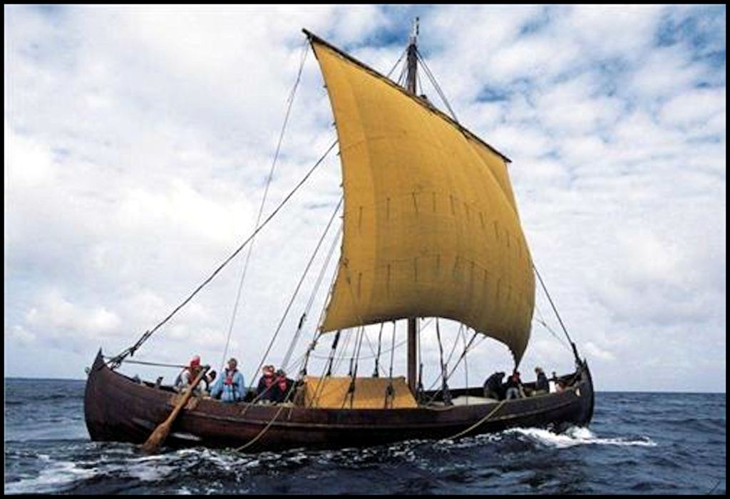
A Early Medieval Scandinavian knarr or carbo ship
In the next article
The Muskogee-Creek Dictionary contains numerous Indo-European words and word roots. The primary Muskogee-Creek for water, ue, is Illyrian from the Adriatic Sea Basin and Atlantic Coast of France. However, there are approximately six pages of words, having to do with water, which incorporate the Latin word for water, aqua.
Indo-European influence can be found in tribal and place names between the Ogeechee River in Georgia and the Santee River in South Carolina then northward several hundred miles in the Southern Highlands. Astonishingly, I found one tribal member of the Creek Confederacy, whose name could only be one language, Archaic Anglisk (English) . . . the language that they spoke in Scandinavia. Most of the tribal names appear to be of Pre-Gaelic or Gaelic origin, however. See you next time!

Simply Brilliant !!
LikeLiked by 1 person