Part One of Track Rock Gap . . . 10 years later
by Richard L. Thornton, Architect and City Planner
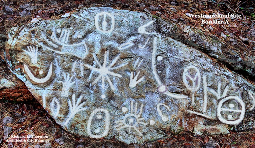
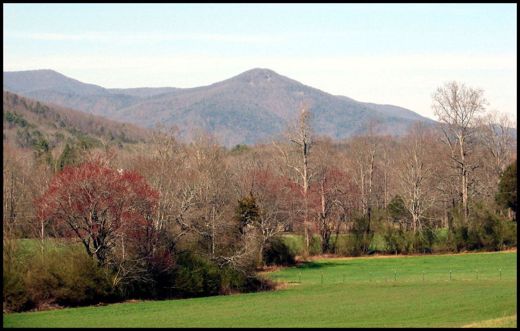
Swedish Bronze Age symbols on a boulder in the Chattahoochee National Forest
The US Forest Service plans to assign control of archaeological and historical sites in the Chattahoochee National Forest to four out-of-state Native American tribes, who have been gone for two centuries. They would have authority over who visited these sites, who photographed or filmed these sites and how these sites were interpreted. Ten years ago, when the US Forest Service closed access to the Track Rock Gap in Georgia, the official reason was that “some” North Carolina Cherokees objected to the photographing of their ancestors’ graves. No names were given.
The three federally-recognized Cherokee tribes have no connection to the stone ruins, mounds or petroglyphs that USFS would have them control. According to Cherokee Principal Chief Charles Hicks in his History of the Cherokee People [1826], the Cherokees never built mounds, arrived in northeast Tennessee around 1670 and did not live in Georgia [south of the Hiwassee and Tallulah Rivers] until after the American Revolution.
The Muskogee Creek language was never spoken in northern Georgia. The region was occupied by Uchee, Chickasaw, Shawnee and Kansa, plus branches of the Creeks speaking Itsate, Kusate, Apalachete and Sokee. However, some members of these ethnic groups did eventually get deported to the Indian Territory along with the Muskogees. Their descendants are members of the Muskogee-Creek Nation. They are a minority, however. Most North Georgia Natives either assimilated with their white neighbors or moved to Florida to become Seminoles.
Irate Georgia citizens, especially those living in the mountains and Native American descendants, are racing to their US Representatives and Senators, plus state officials, trying to stop what appears to be yet another “done secret deal” by bureaucrats in Washington, DC, which would allow outsiders to dictate policies to local communities, plus block access to people, who they don’t like. Georgians would prefer to see all of these multi-cultural sites under the stewardship of a partnership between local historical-architectural organizations, the Georgia Department of Natural Resources and the National Park Service.

The Georgia Mountains contain much more than “Indian Mounds.” These brick-shaped, quarried, basalt stones were the foundation of a 17th century European’s house on Lynch Mountain [GA].
The Georgians’ concerns about a threats to their cultural and economic sovereignty are very real. Several years ago, the Eastern Band of Cherokee Indians in North Carolina dispatched two realtors to buy as many Uchee, Chickasaw, Apalachete and Creek mounds in Georgia as possible, so they could declare them to be Sacred Cherokee Heritage Sites. (Yes! Really!) The two realtors also reportedly bought 500 acres near Cleveland, GA to build a gambling casino . . . not knowing that all land south of Yonah Mountain had always been Chickasaw territory, until ceded to the United States.
Already, interference into the affairs of the US Forest Service by the Eastern Band of Cherokee Indians in North Carolina has cost Union and Towns County, GA millions of dollars in tourism income. The History Channel’s premier of “America Unearthed” on Track Rock Gap has become the most watched H2 program ever. Yet, for the past ten years the path giving access to its half square mile expanse of stone ruins has been first concealed then blocked by USFS employees. The EBCI takes credit for this travesty, because of the farcical claim that the agricultural terraces are the burial sites of great Cherokee chiefs. The terraces were built around 1000 AD! EBCI officials also claim that they were responsible for National Geo, the History Channel and PBS not being allowed to film these stone ruins
Between 1998 and 2002 there was a concerted effort to persuade Georgia officials to lease Etowah Mounds National Historical Landmark to a private developer for $1 a year, so he could convert the facility into a “Cherokee Museum.” In 2006, a delegation of North Carolina Cherokees showed up at the Etowah Museum, demanding that all references to the Creek Indians be removed. They almost succeeded until an alliance of Creek descendants and archaeologists raised heck about the ridiculous idea.
Descendants of immigrants, who came from Siberia, northern Europe, western Europe, Peru, the Amazon Basin, Mesoamerica, France, Iberia, West Africa and the Middle East created the Georgia Mountains’ architectural heritage and petroglyphs over many thousands of years. After them came thousands of miners to the nation’s first major gold rush. The closest living relatives to the people, who built the many earthen pyramids and burial mounds in the Georgia Mountains are the Town County Indians near Hiawassee, the Coosa Creek Indians in Union and Towns Counties, plus the 200,000+ Native American immigrants* from southern Mexico, Guatemala, Peru and Belize, now living in Georgia.
* Georgia now has over 1,000,000 Latin American residents, so the number of Georgia residents, genetically related to the “mound builders” may be much higher.
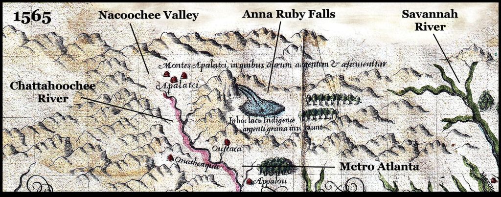
Map by Jacques Le Moyne – resident artist at Fort Caroline. It was based on a six month expedition to the Southern Highlands by Lt. La Roche Ferriere of Fort Caroline. Survivors of Fort Caroline in the autumn of 1565 were invited to settle among the Apalache, with the condition that they marry Apalache women.
Historical Background
Two Native American communities live in the vicinity of Track Rock Gap today, but neither is federally-recognized. The Town County Indians near Hiawassee, GA carry high levels of Southern Arawak and Maya DNA. The Coosa Creek Indians in Union and Towns Counties, GA are descendants of a large Upper Creek town, located near Blairsville, GA. Their ancestors managed to avoid the Trail of Tears because their names were not on the census of Cheorkee INdians.
In the late 1500s, when Spanish and French explorers ventured into the mountains of Georgia, the Southern Highlands were dominated by the Kingdom of Apalache, whose capital was in the Nacoochee Valley, which contained the headwaters of the Chattahoochee River. The mountains were called the Apalachen, which is the plural of Apalache. These were the real Apalache. The Spanish mistakenly called an Arawak people in the Florida Panhandle, Apalache, but they did not call themselves by that name.
The Apalache were descended from a Panoan People from Peru, who probably arrived in Georgia around 2,000 years ago, but this is not certain. They initially intermarried with the aboriginal Uchee. Those hybrid descendants later intermarried with Chickasaw immigrants (c. 600 AD) and Itza Maya immigrants (c. 550 AD, 800 AD, 1000 AD), Cho’ite Maya immigrants (c. 1100 AD?) and Soque immigrants from southern Mexico (c.1250 AD).
In 1570, the King of Apalache established a town named Melilot for British and French Protestant immigrants, where Little Mulberry River Park is now in NE Metro Atlanta. It appeared on European maps until 1700. Hundreds of Sephardic Jewish and Asturian gold and gem miners moved into the Kingdom of Apalache during the late 1500s and 1600s. They married Native American wives.
The immigrants also formed vassal provinces of their own. The Chickasaw lived in NE Georgia until 1818. They lived in NW Georgia until 1785. The Kansa, a Siouan tribe, occupied the Coosa River Basin until around 1600 AD. Upper Creeks and South American tribes from the Georgia coast occupied the region south of the Coosa River Basin until around 1790 AD. Arawaks and the Allatoona, a South American tribe, occupied the upper Etowah River Basin until around 1700 AD. They were replaced by Apalache. Uchee families lived on the Upper Tennessee River until 1838. They lived on the Chesnatee and Notteley Rivers until the 1830s.

Arnout de Leers 1658 engraving of the Capital of the Apalache Kingdom in the Nacoochee Valley of Georgia
Georgia is a very different world than the Great Plains
North Georgia is not the Great Plains, the Southwest Plateau or the Northwest Pacific Coast. Policies of federal agencies, designed to please individual tribes in mono-cultural locales are NOT applicable here. Human occupation goes back to at least the Clovis Period. There are numerous town and village sites that were occupied from the Late Archaic Period to the end of the 17th century. Petroglyphs in the Chattahoochee, Nottely and Savannah River Basins are identical to those Bronze Age sites in southern Sweden and sometimes include portrayals of Bronze Age ships. Petroglyphs in the Etowah River Basin are identical to Bronze Age petroglyphs in SW Ireland and the region around Dundee, Scotland. Northeast Georgia abounds in stone circles, stone ovals, monoliths, stone cairns and stonewalled terrace complexes. There are many small scaled mounds and a few large ones.
The Upper Chattahoochee River Valley is considered to be the most densely occupied occupation zone, north of Mexico. The Nottely River Valley is almost as dense. Several terrace complexes are located there. In both valleys, there are long-occupied sites, usually with modest mounds that are within a couple hundred feet of each other.
While working in the Upper Chattahoochee River Basin in 1939, archaeologist Robert Wauchope noticed an odd stratigraphy, not seen elsewhere in North America. Permanent occupation of sites began much earlier than was assumed in 1939 to be possible. Radiocarbon dating was unavailable, but especially when European artifacts began appearing in layers, he was able to use the styles of artifacts to determine approximate dates.
European artifacts first appeared in the late 1500s, then increased in quantity and quality over the next century. They were always mixed with high quality Lamar Culture artifacts. Wauchope came to a point where all artifacts stopped. There was a layer of five to fifteen feet of sand (probably volcanic ash) then from there upward only European artifacts were found . . . all the way to 1939. We know that some Native Americans lived in the Nacoochee Valley till 1821, but apparently, they were totally Europeanized.
We now know that there was a violent eruption of the Chimney Mountain Volcano, six miles to the north, around 1700 AD. This probably melted snow, which caused flooding, mixed with deep volcanic ash and alluvial sand.
At the time, Georgians assumed that all of the archaeological sites in northern Georgia were Cherokee. Wauchope could not find a single Cherokee artifact or village. All of the artifacts were the same style as Archaic Period, Woodland Period and proto-Creek artifacts in Middle and Northwest Georgia. He did not unearth any of the Sephardic Jewish and Spanish mining villages, but did uncover an immense amount of detritus, associated with the Georgia Gold Rush.
Using USGS infrared images, my own infrared camera-binoculars and a LIDAR scan, furnished to me by the county planning department, I was able to find the fort, trading post and Catholic mission, built by the Spanish in 1646. I must add though, that this fort footprint may actually be one built by Captain Juan Pardo in 1567. Being a historic preservation architect, I do not disturb archaeological sites in anyway.
Chimney Mountain, a gas volcano, overlooks the Nacoochee Valley from the north.
I can’t emphasize enough. I agree totally with my fellow Georgians. The Chattahoochee National Forest is NOT the place for federal agencies to play social engineering or put on a new face as being Native American friendly. It is a complex multi-cultural archaeological zone that contains information, which may change the history of North America or world. The US Forest Service has not maintained and damaged logging ancient stone ruins that should be on the National Register of History or even National Landmarks. This not the time for them to play tribal politics.
This is a region that demands the broad type of cultural education given European and Latin American archaeologists and is oh-so-rare in North American universities. In subsequent articles, I will explain the behind-the-scenes petty politics and occult agenda that affect archaeological sites in the Southeastern United States.


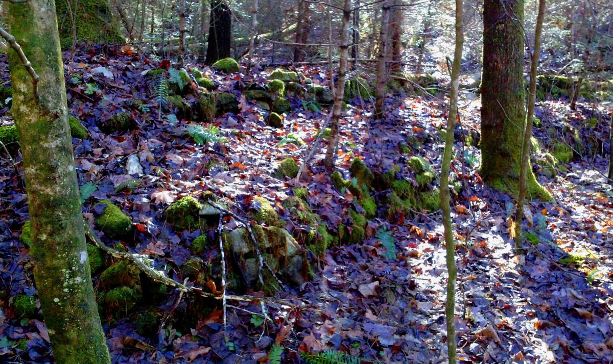
These are stacked fieldstone sarcophagi in the Nacoochee Valley that are typical of the gold-mining region of the Iberian Peninsula during the Late Medieval Period and 1600s. They are most common in Galicia, Asturias and Navarre.
