Never heard of Fort St. George? It was founded in present-day Maine, only a few months after Jamestown, but much larger and drastically more sophisticated. Fort St. George is one of those many stories that are left out of North American history books. So far, it is the only early English colonial architecture that I have been asked to study. Continuing the celebration of my 20-year marriage with Artlantis of Paris, France, we will show several views of the colony, plus contemporary 16th and early 17th water colors of other colonies. The illustrations in this article are among hundreds in my book on 16th and early 17th century colonial architecture, Earthfast – The Dawn of a New World.
by Richard L. Thornton, Architect and City Planner

There is increasing evidence being found by Canadian archaeologists that British fishermen “discovered” North America and established a fishing station village on an island near Newfoundland, several years before the oft-glorified first voyage of Cristobal Colon (Columbus). This was claimed by English historian, Richard Hakluyt, in his book, Divers Voyages Touching the Discoverie of America (1582). Hakluyt’s book was used by Queen Elizabeth I to lay claim to all of North America, north of Florida Française (present-day Georgia and South Carolina). She assumed that Florida Française would be colonized by England’s allies, the French Huguenots. France NEVER claimed the land in the present-day State of Florida, where the fake, 1/12th scale model of Fort Caroline is located.
Originally, all lands between Florida Française and Newfoundland were called “Virginia.” Richard Hakluyt was a major factor in Queen Elizabeth I issuing a patent for the creation of the Roanoke Colony in present-day North Carolina and then was the chief promoter of a petition to James I for letters patent to colonize Virginia, which were granted to the London Company and Plymouth Company (referred to collectively as the Virginia Company) in 1606. The London Company sponsored Fort James (Jamestown) while the Plymouth Company sponsored by the Plymouth Company.
The well know Plymouth Plantation colony in Massachusetts was actually contracted with the Virginia Company. However, after arriving on the coast of North America, the occupants of the ship, Mayflower, learned that there was a smallpox epidemic and Indian war in Virginia. Since they had formerly lived in the Netherlands, they initially considered landing at the Dutch colony, New Amsterdam, but then foolishly decided to land at Cape Cod.
Left out of American textbooks, but found in French textbooks, is the story of another shipload of colonists in 1621. For the same reason as the “Plymouth” colonists, they decided not to land in the midst of a plague and Indian War then sailed on to the mouth of the Savannah River. They somehow made their way inland to the Kingdom of Apalache, where they were granted lands by its king. The king practiced the French Protestant religion and so allowed them to build an Anglican church, somewhere in Northeast Georgia. Archaeologists have never looked for the site of their colony, but it was probably in the vicinity of Little Mulberry River County Park in Northeast Metro Atlanta.
For most of the 16th century, English royalty and nobility had showed little interest in establishing colonies in the New World other than secret fishing stations on or near Newfoundland. They found it far simpler and profitable to focus on the conquest of Ireland, while covertly assisting the rebellion against Spain of provinces across the Channel in what is now Belgium and the Netherlands. In fact, the forts built by the Roanoke Colony in Puerto Rico and North Carolina, plus the fort at Jamestown, Virginia were identical to the standard forts built in several parts of Ireland to protect Protestant colonists.

This fort in County Cork, Ireland was built to hold an English garrison that protected the recently-arrived Protestant colonists. As seen below, Roanoke Colonists built identical forts in southern Puerto Rico and in Roanoke Sound.

This triangular timber palisade fort, occupied by Scottish Protestants in County Ulster was intended to protect colonists. It was defended by local militia, rather than professional soldiers from England.

Fort Raleigh, built on Roanoke Island by the first Roanoke Colony. Painting courtesy of the National Park Service.
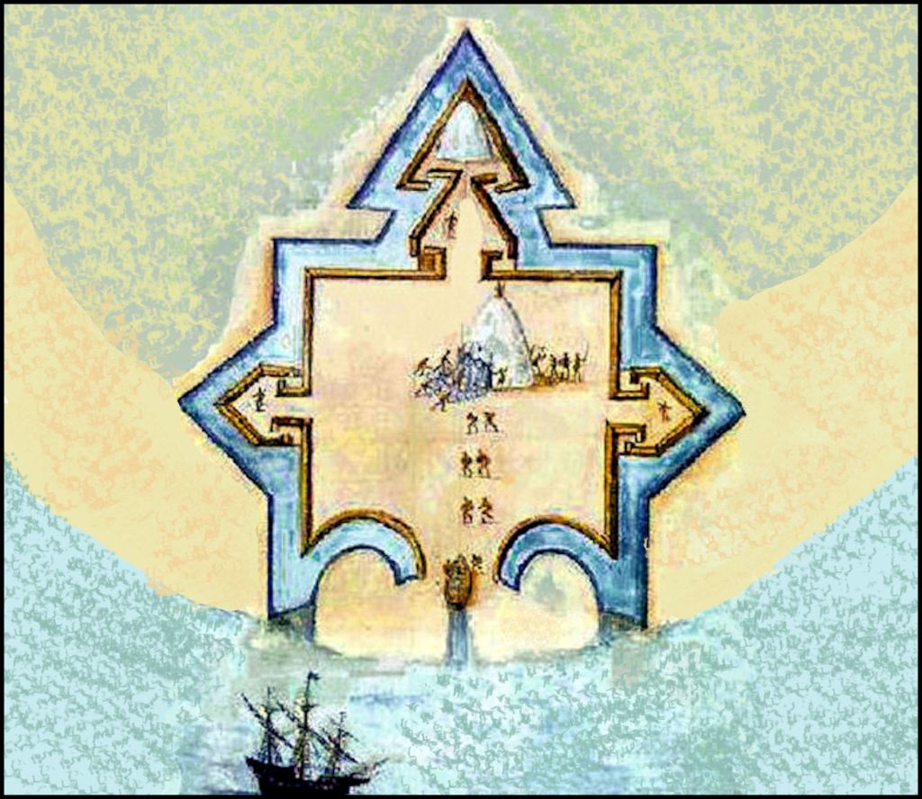
Fort Raleigh, built by the second Roanoke Colony Expedition on Guayaquila Bay on the south shore of Puerto Rico. It is believed that the second Roanoke Colony built a timber palisaded fort in this same shape on Roanoke Island. This water color is by John White, Governor of the Colony and father of Eleanor Dare.
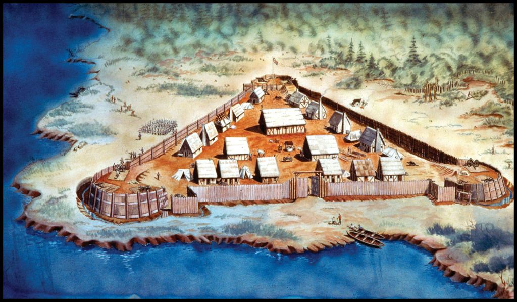
The original 1607 fort at Jamestown – courtesy of the National Park Service
Construction Details

The original houses in Fort James (Jamestown) had construction details similar to to traditional Creek Commoners’ wattle and daub houses, but structurally inferior . . . except they also had extremely dangerous internal chimneys, framed with saplings. The coastal mud, used to daub the sapling frame was vastly inferior structurally to the clays available in the lower Southeast. Essentially, sandy dirt, the daub in Jamestown was prone to dry and drop off the sapling frame . . . thus exposing the sapling frame to sparks from the dirt fireplace. Early Jamestown houses were constantly burning down.
Creek and the coastal peoples of Georgia and South Carolina wove their walls with extreme strong river cane lattices like a basket. The Maya-Totonac-Creek word for house, chiki, is derived from the Maya verb, which means “to weave a basket.” In order to resist winds from hurricanes and tornadoes, Georgia Native American houses also had compression bands composed of thick wild grape vines.
The clay daub of Georgia and South Carolina Native American houses contained oyster or freshwater mussel shells for reinforcing. Coastal houses and important public buildings within the interior were coated by a stucco made of hydrated lime, sand, white kaolin clay and crushed shells. The stucco protected the daub from rain storms. Virginia settlers did not do this, but Spanish colonists at Mission Santa Catalina de Guale and Pueblo Santa Elena utilized Native American laborers, who constructed vastly superior houses to those initially constructed at Jamestown. Creek stucco is the origin of tabby construction.
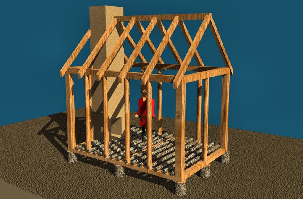
Both the houses and public buildings at Fort St. George were vastly superior to the shabby construction of Virginia’s initial buildings. They were framed with sawn timbers and the chimneys were constructed of plastered stone masonry. The only “weak point” of houses at Fort St. George were its foundations. To save time, since winter was approaching, the carpenters used tree trunks for foundations, instead of stone masonry. The tree trunk foundations would not have lasted more than five years. Apparently, England did not have termites!
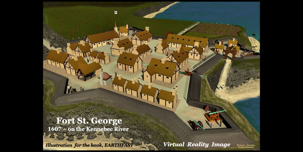
Fort St. George (1607)
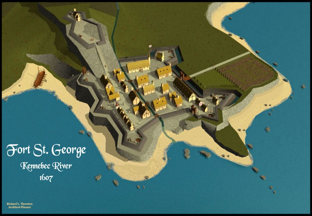
Also known as the Popham Colony or Sagadahoc Colony, it was established by the Plymouth Company, a division of the London Company, near the mouth of the Kennebec River near present-day Phippsburg, Maine. Its principal financial backer was Sir John Popham. The president of the colony was George Popham, whose team did a far better job of planning and provisioning the colony than the Virginia Company did for Fort James. The town plan was starkly more sophisticated than Jamestown. The colonists brought with them at least nine cannon capable of dueling with warships. The colonist of Jamestown originally had no large cannon.
Fort St. George would have been the first English colony, since the failed attempt at Roanoke Island, except . . . the Plymouth Company’s ship was captured by the Spanish off the coast of Florida in 1606. What in the heck were they doing down near La Florida?
Thus, the second band of colonists intended to make their town impregnable to attack by sea or land. Once constructed, the fortress only had one serious obstacle . . . its location. The town was an ideal location for fishermen or building ships, but nearby soils and terrain were totally unsuited for any agriculture other than raising livestock. Its occupants would always be dependent on imported vegetables and fruits. Then, there was the wintertime. Fiercely cold winds roared down the Kennebec River Valley, making the town site miserable and often covered with fog in winter months.
Actually, Fort St. George had a much better start than Jamestown. Several of its colonists were professional fishermen and mariners. The first sea-going ship, constructed by Englishmen in the Americas, was built there. Hunters brought in a bounty of game from the woods, while fishermen brought in fish and other colonist collected oysters, mussels, clams, crabs and lobsters. Yet, the fort was only occupied 14 months.
There was no effort to develop trade relations with the nearby Abanaki Indian. For unknown reasons, the colonists did not attempt to preserve the meat and fish for themselves, when the weather was good. Their salted fish seems to have been shipped back to England to produce income for the Plymouth Company. Extreme cold made hunting and fishing difficult by November. Because of the lack of food sources of other than protein, half of the 120 colonists returned to England in December 1607.
Town President, George Popham, died on February 5, 1608. He was the only colonist, known to have died, whereas half of the population of Jamestown died the first year. In May 1608 a supply ship brought a message that Sir John Popham had died. The supply ship returned to England with a cargo. When a ship returned in September 1608, it brought news that elder brother of the new president, Raleigh Gilbert, had died. Gilbert thus inherited the title and the estate of Compton Castle in Devon. He decided to return to England and as no other leader was found, the colony decided to disband and the remaining colonists sailed home.

Architectural drawing of Fort St. George by John Hunt (1607)
The reason that I was able to create such a detailed computer model of Fort St. George was that a three-dimensional drawing was prepared by colonist John Hunt on October 8, 1607. Hunt was at least a trained architectural draftsman . . . from the sophistication of the design, possibly an architect. In addition, archaeological work, directed by Jeffrey Brain of the Peabody Museum at Harvard, has identified specific buildings within the town plan. Now we will take you on a virtual tour of Fort St. George.
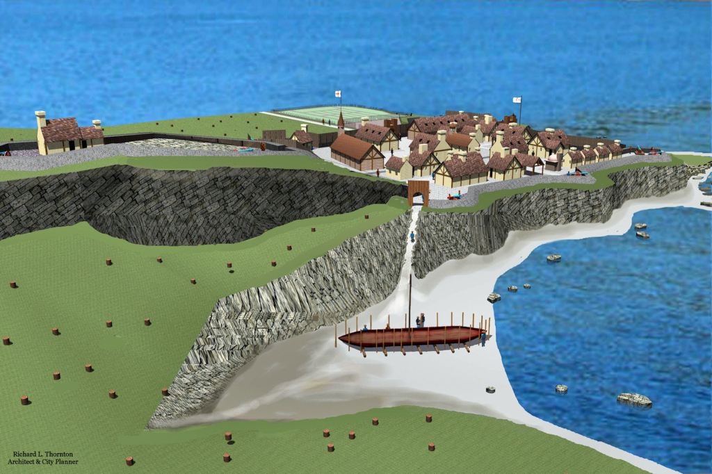
Fort St. George was expected to develop into a major ship-building center, because of the abundance of large trees in its vicinity. One sea-going vessel was constructed there.

All seaward approaches to the town were protected by large cannons.

Thick walls of granite fieldstones and clay morter protected the cannons.

The town was protected from a land-based assault or amphibious assault on the beach by a second fort on the steep hill above. Sentries in this fort could see ships approaching up to 20 miles (32 km) away.

Fortifications and armament were especially robust on the west side of the town, where the colonists hauled in top soil to create vegetable gardens.

Detail of west side of the fortifications

The town plan for Fort St. George included several plazas for socializing and regularly spaced drainage ditches (rear of image). Jamestown’s construction made no provision for storm drainage or human waste. Fort St. George also had pure water to drink, while the water of Jamestown’s well quickly became biotoxic. Later a Spanish spy actually poured arsenic into the well.

Unlike Jamestown, Fort St. George contained a large warehouse, occupied 24/7 by armed guards.

Fort St. George could have become the most successful of any of the early colonies founded by European nations in North America . . . had it been built 400 miles farther south! LOL
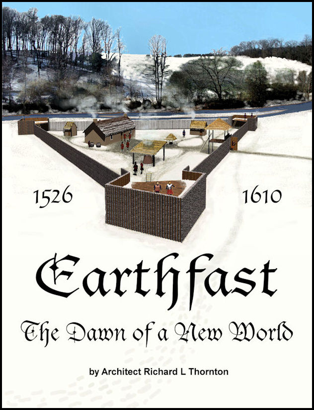
Earthfast , , , The Dawn of the New World is (inexplicably) the only comprehensive book ever published on the early Colonial Architecture of North America, constructed by France, Spain and England. It is a must have for historic preservation architects, archaeological firms and university architecture programs. It is heavily illustrated with virtual reality images created with Artlantis, architectural drawings by the Author-Architect, photographs of archaeological sites and copies of historic maps.
For those, who can’t afford the printed book, the publisher offers an inexpensive digital version in an Adobe PDF format. The printed book is least expensive, when purchased from the publisher:
The book is also available from Amazon.com, UKBookshop.org, Barnes and Noble, Walden Books, Walmart, AbeBooks, Thrift Books and Better World Books.
