34°05’57.2″N 83°27’38.3″W
It is one of the best preserved Native American town sites that I have ever studied. Ancestors of the Apalache branch of the Creek Confederacy occupied the site from at least as far back as around 1000 BC to 1785 AD, when the land was ceded to the State of Georgia. Three different archaeological teams worked here in the late 20th century, but in different sections . . . not realizing how large the town was. The new owner of the property, the Jackson County government, is currently contracting with archaeologists, who will thoroughly study the 3 1/2 mile long town along the North Oconee River. Once the architectural and archaeological assets are completely mapped, this will become a park, open to the general public.
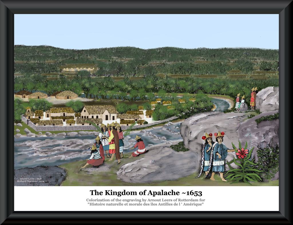
It is highly probable that French explorer, Lt. LaRoche Ferrière, visited here in 1564, and English explorer, Richard Brigstock, visited here in 1653. Ferrière paddled up the May (Altamaha) River to the Oconee River from Fort Caroline to establish trade relations with Apalache then spent six months exploring the Southern Highlands. His boss, Captain René de Laudonnière, planned to build the capital of New France on a natural terrace, overlooking the Oconee River, where the University of Georgia now sits.
Brigstock, a planter from Barbados, probably came up the Savannah River, because there were still Spanish missions and forts around the mouth of the Altamaha. He was examining the possibility of a group of planters from Barbados joining the existing European colonists in the Kingdom of Apalache. By this time, the capital of the Kingdom of Apalache had moved northward to the Nacoochee Valley, but Brigstock first visited the older Apalache towns along the Oconee and Apalachee Rivers.
French natural scientist, Charles de Rochefort, devoted 10 chapters of a book to the information provided him by Brigstock. Those chapters provide detailed, 100% accurate information on Creek architecture and fortifications that archaeologists didn’t know until the late 20th century.
Brigstock spent the better part of 1653, based in the Nacoochee Valley, exploring several sections of the Kingdom of Apalache. He mentioned a town that stretched over three miles along a small, rapidly flowing river, along the route between present-day Athens, GA and the edge of the gold belt in present-day Gainesville. GA He ultimately decided to move to Virginia, because the King of Apalache did not allow human slavery and required unmarried Europeans to marry Native American spouses.
by Richard L. Thornton, Architect and City Planner

How to know if you have Apalache or Soque ancestry
Until around 1750, the “Middle Creeks” called themselves Apalache or Palache. At that time, the newly elected High King or “Principal Chief” in modern lingo, was Malachi Bemarin, a man of mixed Coweta Creek and Sephardic Jewish ancestry. He changed their ethnic name to Maskoki, which is a combination of the Ladino (Sephardic) word for “Mixed” and the Gaelic-Algonquin suffix for tribe. Muskogee is the Anglicized version of Maskoki.
The Apalache and Soque Peoples of Northeast Georgia were partially descended from Panoan peoples in Eastern Peru. That made them genetically, linguistically and culturally different from the Itsate Creeks and Muskogee Creeks. However, the Itsate, Soque and Apalache lived in close proximity and were allies – thus, typically mixed their genes. If you carry Southern Mesomerican (Maya), Panoan DNA, plus Sami, Finnish and Basque DNA that cannot be explained by recent ancestors, you ae probably part Apalache or Soque. Soque descendants usually also carry some Polynesian DNA.
Northeast Georgia’s incredible Native American heritage
Early leaders of the colonies of South Carolina and Georgia repeatedly stated that the most advanced Native American cultures, north of Mexico, were located in Northeast Georgia. Some specifically stated that these peoples had many cultural traits similar to the advanced peoples of Mexico, except that they did not practice any form of human or animal sacrifice. The region abounds with ancient earthen and stone architecture, plus numerous petroglyphs that often identical to those created in Northern Europe during the Bronze Age. Some petroglyphs even contain images of Bronze Age ships.
Something odd occurred, though, at the federal and state level. Over a century ago, US Department of Interior maps began labeling the region as always being “Cherokee” when in fact, no map of the Southeast even mentions the Cherokees until 1715, and the territory of the Creek Confederacy extended as far north as Yonah Mountain and Clarkesville, GA until 1818, when that region became part of Georgia. Archaeologist Robert Wauchope found no evidence that ethnic Cherokees ever lived northeast Georgia. He never found a single Cherokee artifact or village during a year of on-site research.
The aboriginal peoples of Northeast Georgia, north of Yonah Mountain, were placed in the territory of the Cherokees by the federal government in 1784, but they retained their Uchee, Soque, Chickasaw and Creek cultural traits, plus were not allowed to participate in the Cherokee tribal government. The Cherokee names of Yonah Mountain and Walasi-yi Gap were given by white settlers AFTER the Cherokees were gone. All other Native American names of rivers or mountains in Northeast Georgia are either Creek, Maya or Arawak words.
In my research into the ancient stone ruins, I am dependent on the work of archaeologists Charles C. Jones (1873), Cyrus Thomas (1886), Robert Wauchope (1939), Phillip Smith (1951) and Arthur Kelly (1950s), because since that time, university archaeologists have generally ignored Northeast Georgia, even though it contains Georgia’s densest concentration of archaeological sites.
A decade ago, the Jackson County and Athens-Clarke County Historical Societies begged the University of Georgia’s Anthropology Department to study the stone and earthen structures at Sandy Creek County Park. Even though the fully accessible park was only six miles from the University, its archaeologists refused . . . stating that “they didn’t want to want get involved with the Maya Thang.” I am part Maya. The Maya Thang is no problem for me. LOL

Large V-shaped retaining wall, oriented to the Winter Solstice Sunset at Sandy Creek County Park in Jackson County, GA
Jackson County, Georgia protects its heritage
This rapidly growing county of approximately 78,000 residents is located in Northeast Metropolitan Atlanta. It is transected by the Interstate 85 Corridor. In official state history texts and internet reference sites, it is noted only as the site of the first use in the world of anesthesia in surgery. Dr. Crawford W. Long used “laughing gas” in 1842 to remove a tumor from a young man’s neck. Long lived in Jefferson, GA which was formerly named Thomacoggin.
Prior to the late 1700s, however, Jackson County had a dense indigenous population, composed of several branches of Creek Confederacy, including tribes that had once been neighbors of Fort Caroline on the coast of Georgia, such as the Thomacoggin. The original name of the county seat was Thomacoggin. This is why we know for certain that Fort Caroline was on the Altamaha River in Georgia. Their towns were located on tributaries of the Oconee River, which joins the Ocmulgee River in central Georgia to form the Altamaha. Not only do all European maps label the Altamaha as the May River, plus locate Fort Caroline there, but even the 1793 US Government map of the Southeastern United States notes that the Altamaha was formerly named the May River.
As long as Jackson County was predominantly rural, the local population was aware of its rich Native American heritage, but its many earthen pyramids and stone ruins did not seem threatened and generally were not damaged. Rapid industrialization and construction of many new residential developments has radically changed the situation. Historic preservationists and elected county leaders became justifiably concerned, when they saw ancient Native American town sites and legacies from the early 1800s in Gwinnett County to the south being destroyed by developers. The Apalache also densely occupied Gwinnett County. (see paragraph below).
What dismayed them most was that neither the Georgia Division of Historic Preservation nor the archaeologists in Georgia made any effort to protect ancient stone architecture and Creek Indian earthworks in Metro Atlanta. Private firms were happy to get contracts to dig up their precious little potsherds and points, so they could be inventoried, reported on and forgotten. However, not one archaeologist or state historian made an effort to stop the destruction of these sites. Section 106 reviews of archaeological sites about to be destroyed, are the “bread and butter” of contemporary archaeological firms in the Southeast.
The Gwinnett County Chapter of the American Institute of Architects did adopt a resolution opposing the destruction of ancient and historic architecture in Metro Atlanta, but apparently the Atlanta Area news media ignored them . . . as did state bureaucrats. Jackson County leaders eventually realized that if they were going to stop the destruction of their cultural heritage, it would be local folks, who would have “to take the bull by the horns.”
The Historic Preservation fiasco in Gwinnett County, GA
Gwinnett County, GA is in NE Metropolitan Atlanta on the Interstate 85 Corridor. Its current population is approximately 967,000. Also located in the Altamaha-Oconee River Drainage Basin, Gwinnett County supposedly has over 500 designated archaeological sites. However, it lost most of its Native American mounds and stone structures in the last three decades of the 20th century. Don’t blame its citizens and leaders. That period saw a series of mostly lost, but highly publicized battles to save the major archaeological sites.
Until her untimely death in 2010, Interior Designer Marcia Hudgens Duggan was a driving force in the Gwinnett Historical Society. Theoretically, her family had disproportionate political influence to stop the steady destruction of ancient sites of humanity. Her father was Scott Hudgens, developer of the Mall of Georgia in Gwinnett and one of Georgia’s most prominent real estate developers . . . and a lover of history like his daughter . . . but that didn’t seem to help. They could get no support from either the state government or the archaeologists, who were operating at the time.
You see . . . I have an inside track on this one. I was a classmate and friend of Marcia’s at Lakeshore High School in College Park, GA. My official father was Secretary and Treasurer of Scott Hudgens, Inc. during that era. Marcia’s family, including her parents much later joined Peachtree Christian Church in Atlanta, where I was a deacon.

I was living outside of Georgia when most of the destruction occurred, but this is what I learned, when I reconnected with the family after returning to Georgia. Scott purchased a large tract of land in Gwinnett to build a multi-use development, including a mall. The site contained a complex of terraces, formed by ancient stone walls, plus what appeared to be the ruins of stone buildings. He wanted to save the ancient terraces and ruins by counting the area they covered as a “natural buffer area”. A certain percentage of the total land area of the project site was required by the zoning ordinance to be preserved in this classification. However, the ruins were not on the edge of the property. That was a problem.
Both the Gwinnett Planning Commission and the County Commissioners were completely sympathetic. They said that the moss covered rock ruins would have be declared “historic” for them to give a waiver on having an internal natural buffer. Keep in mind that any complex of stone structures may be placed on the National Register of Historic Places, if over 50 years old and of local or state cultural significance. Gwinnett leaders were not even demanding a National Register designation.
The Georgia Historic Preservation Division refused to grant a historical label to the site, unless it was first designated so by a professional archaeologist. Scott had great difficulty in finding firms that would even look at the stone complex, because of past controversies in which citizens had tried to oppose development of Native American sites. Some firms refused to take the job unless they be awarded large contracts to excavate the site. This would have delayed the project for two years since the ruins were near the center.
One firm agreed to dig only test holes, but then afterward refused to label the ruins “historic.” Scott hired two more Georgia archaeologists, who then, after getting their check, refused to call the ruins, “historic.” He had already lost several hundred thousand dollars in interest payments so reluctantly moved ahead with the project and covered the stone ruins with dirt.
My response? First, I told her that the state historic preservation agency had been conning many local governments with this demand. In the United States archaeologists, per se, are not licensed professionals. In most parts of the world, only licensed architects, civil engineers and geologists may sign legal affidavits, declaring the age of a structure. In Scott’s case, he should have hired a licensed historic preservation architect and a licensed geologist. A geologist has the skills to determine the age of moss growth and chemical change on an exposed rocks. Evidently, large trees were growing with the ruins. The age of the trees could have been dated via core samples.
Whether or not, archaeologists happened to find a certain number of stone Native American artifacts in a few test pits was not mandatory. Maybe the builders were not Native Americans still in the Stone Age . . . or had no reason to drop spear points and bits of pottery near the walls! Maybe it was a vineyard built 450 years ago by Sephardic Jewish refugees. That still, very much meets the criteria of being “historic.”
That’s the problem that we are still having. Rather than objectively describing what they observe like architects and civil engineers are taught to do, many archaeologists today in the Southeast, ignore or even hide anything that conflicts with their theoretical view of the past. I don’t know who built those stone structures underneath Scott Hudgens’ real estate development, but they were definitely “historic.” No one will, because they are deeply buried under buildings and parking lots.
In the early 1950s, Harvard University archaeologist, Phillip E. Smith, found copper, bronze and iron weapons and tools inside both earthen and fieldstone mounds in the Upper Oconee River Basin of Northeast Georgia. They are objectively mentioned in his archaeological reports. The next generation of archaeologists in Georgia made sure that the public never knew this.
There was one last, large Native American town left in Gwinnett County, on the Little Mulberry River near Auburn, GA. When this 330 acre tract came in for total redevelopment, the Gwinnett County Board of Commissioners began playing the same sort of games that Scott Hudgens was forced to go through. There were stone cairns, stone retaining walls and stone ruins of very old houses – probably from the 16th or 17th century on the site, plus many agricultural terraces without stone walls. It was obviously historic, but no archaeologist would say so. The county government “bit the bullet” and bought the entire tract to create a recreational park that also happens to contain numerous ruins.

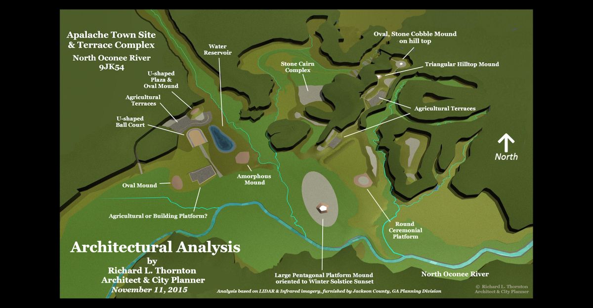
LIDAR scan of the North Oconee – Cabin Creek Basin, provided to me by Joel Logan of the Jackson County Government with my initial notes.
Thank Joel Logan
There is a politically spun version of events about this Apalache town site, now being replicated in various regional and national media, but here is what really happened. Credit should be given, where credit is due! Mr. Joel Logan is directly responsible for this 3 1/2 miles town site being saved from total destruction.
In 2013, Marilyn Rae and I wrote two books on the early history of Northeast Georgia . . . The Apalache Chronicles, plus Nodoroc and the Bohurons. Both books are available from the publisher, Ancient Cypress Books, or from Amazon.com. Marilyn, a graduate of Boston University, translated the Late Medieval French texts and colonial archives, which considerable portions of our books were based on. Much of both books contains events and places in present-day Jackson County.
After Marilyn and I gave presentations to the historical societies in Jackson County and nearby Barrow County, Joel Logan contacted me. He is the Director of the GIS Mapping Division at the Jackson County Government. On his maps, he had observed numerous features that he thought were Native American earthworks or stone structures. He was highly concerned that Jackson County would lose these legacies, if they followed in the path of Gwinnet County’s experiences.
Joel first pointed out several sites that he thought were Indian mounds, agriculture terrace complexes or ceremonial earthworks. He asked me to take a look at them. I found one massive mound in the flood plain of the Middle Oconee River near the road between Commerce and Jefferson. It had not been designated an archaeological site by the state, but Native American potsherds were endemic on the surface of the alluvial soil.

Later a group of Creeks from Florida and I looked at a possible site for the Yamacutah Shrine. It was definitely a ceremonial terrace, but felt more like a Woodland Period site. Oklahoma Creeks have forgotten about Yamacutah, but it was the most sacred spot among the Creek People. Some of my ancestors attended the last ceremony there in November 1786.

On November 24, 1786, the sun never appeared in the sky, due to haze from several super-volcanoes erupting around the world. Thousands of Northeast Georgia Creeks gathered one last time at Yamacutah, thinking that it was the end of the world.

In June 2015, Joel Logan contacted me again. He had received LIDAR scans for Jackson County that the planning staff would utilize to review a application for developing a subdivision along the North Oconee River. Three archaeologists in the 20th century had dug test pits there and had given the site an official designation. They did not mention mounds or stone structures, but Joel thought he was seeing Native American mounds and many stone structures.
Joel asked me to looked at the site after reading the archaeological reports. I received permission from the planning division to go on the property as their representative. (I am also a professional urban planner!) After giving Joel the noted LIDAR scan, seen above, I did go on site to investigate the forms seen on the LIDAR. The first form I reached turned out to be a large Apalache burial mound. They were traditionally oval-shaped and covered with cobble stones. On the top of such stone mounds, the Apalache placed white quartz stones.
I completed the computer model and 3D site plan, seen at the top of the page in November 2015. However, I never had any contacts with the Jackson County government after then. Guess they did not initially believe what I measured and put on the computer model. Who knows?
Then in December 28, 2021 the Atlanta Area news media flashed with the news that a major Native American archaeological site had been discovered in 2016 near the River Glen Subdivision on the North Oconee River by a law enforcement officer. The county government had purchased the entire archaeological zone and was going to make it into a park.
Joel Logan’s name was never mentioned in the news articles, but soon pieces of the articles began appearing in the national news media and in archaeology magazines. A major reason for me writing this article is for the public to know that a GIS Mapping Director in Jackson County, GA went far beyond the line of duty to save an ancient town site, which is of national cultural significance.
Now you know!

Fantastic post Richard. Why don’t the authorities do their research as well as you do. Or is it that they just don’t want people to know the truth. It simply baffles me.
LikeLiked by 1 person
I have no clue, what’s going on in the state historic preservation office and in this state’s archaeologists. We have so many of the stone ruins and yet they still refuse to admit that they exist.
LikeLiked by 1 person
What are the long wide terraces on the hill immediately south of Cabin Creek?
LikeLiked by 1 person
I am not sure. That area was covered in dense pines and I had a limited time to study the site. Joel Logan was only interested in me verifying that what looked like Indian mounds in the LIDAR was that – and their exact dimensions.
LikeLiked by 1 person
Has LIDAR been used on the Mulberry complex? I would be curious to see what if anything that the mounds shape would provide seeing them all mapped out together. I have been unable to find any mapping of the individual mounds showing each and every ones location to see if they show a larger design.
LikeLiked by 1 person
I have never had direct contact with the Gwinnett County Planning Department, but a recent article on the Americas Revealed will tell you how to access LIDAR scans placed online by the US Geological Survey. The USGS LIDAR is not as sensitive as that available from drones, but it did pick up the terraces at Track Rock Gap. It definitely will pick up mounds. There are not any large mounds at Little Mulberry, but quite a few along the rivers in Jackson County.
LikeLiked by 2 people
I’m local to the mulberry site, I’ll keep doing my research on it. I’ve always wanted to take a GPS to the park with me and pin the ones that I could find.
I can remember when I was in middle school the controversy about the mounds that were disturbed behind the Elisha Winn house in Dacula when they built the subdivisions there. Now we have the Rowan development off of hwy 316 being built, who knows what will be lost there.
LikeLiked by 1 person
Like Google Maps, the USGS mapping system now will tell you the Latitude and Longitude of a specific point on the map. I have somewhere the topographic survey of Little Mulberry River Park, but have not seen it since I moved to this house. Perhaps, you could get a digital copy from the Gwinnett Recreation Department or the GIS mapping Department. The Apalache Research Foundation is doing its best to encourage people like you, since for the most part, current Georgia archeologists have “fumbled the ball.”
LikeLiked by 3 people
Lidar is confirming a very large picture of ancient civilizations in north Ga. As you and I discussed Union county holds very similar if not duplicate developments all around the Notley river basin. We have very few site file records of these developments that I am aware. I am feeling a bit overwhelmed by the amount of information flooding in each week. Our little group will soon be meeting with the Union County commissioner in effort to see what can be done to preserve and better understand the significance of Trackrock and surrounding Notley River Basin archeology. Your information of Joel Logan in cooperation with Jackson county officials gives me some hope I am on the right path of understanding. Thanks again. ch
LikeLiked by 1 person
If Jackson County can do it . . . with all that development pressure on them . . . certainly Union County can!
LikeLiked by 1 person
what about in Nicholson Ga? I’ve found some quite interesting stuff if you’d like to come check it out. Email me Benjispesos@icloud.com
LikeLiked by 1 person
I am not an archaeologist. I am a historic preservation architect-city planner, who documents entire town sites, not individual artifacts.
LikeLike