The last days before the years with no summer . . . Already massive volcanoes in Central America, Central Mexico, Iceland and Indonesia were beginning to erupt. Soon, their smoke and sulphureous fumes would block the sun’s rays in the Northern Hemisphere. In 538 AD a large asteroid or comet struck the Atlantic Ocean off of Cape Canaveral, Florida. It undoubtedly wiped out most of the population of northeastern Florida and southeastern Georgia.
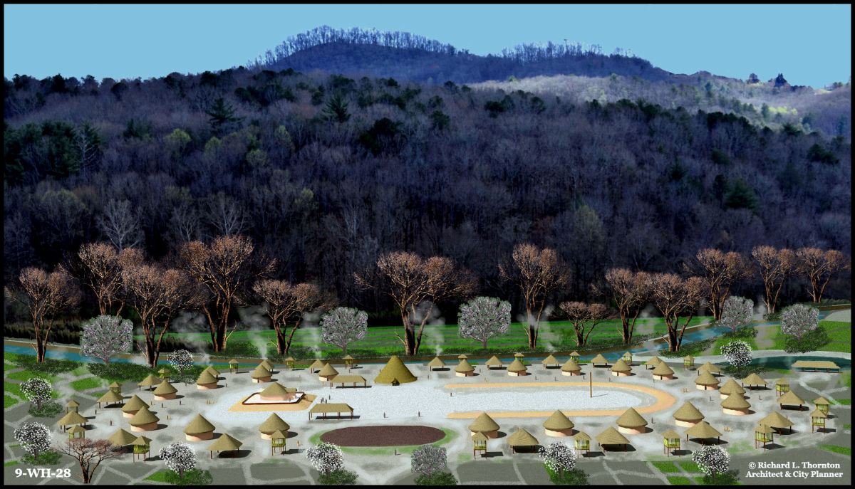
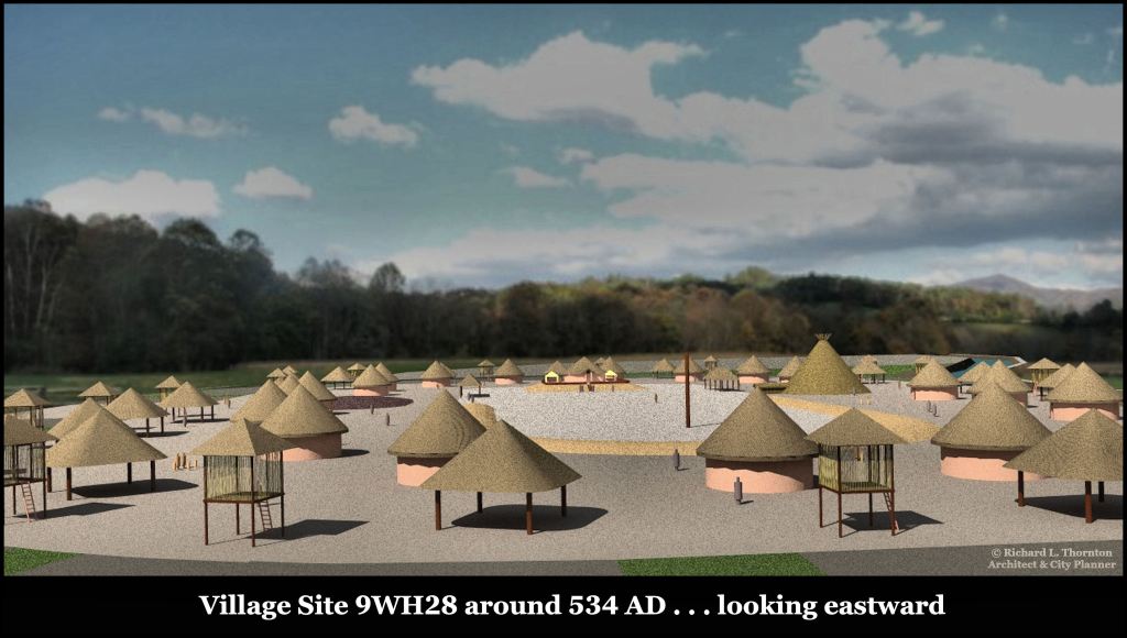
Archaeological site 9WH28 is one of the largest of a cluster of village sites in the present-day Sautee Community, which were occupied between around 1000 BC (or earlier) and 1700 AD. Since archaeologist Robert Wauchope found artifacts going back to the Ice Age in and near 8WH28, it is quite likely that there was semi-permanent base camps at this location for thousands of years. The site is even more special because the discovery of 17th century Spanish artifacts and a infrared scan suggest that this was also the location of a Spanish fortified trading post between 1746 AD and around 1700.
by Richard L. Thornton, Architect and City Planner

The Old Sautee General Store will be the landmark used in this Americas Revealed series, plus in the forthcoming TV program and Youtube documentary film . . . for directing you to sites in the eastern and southern part of the 12 mile long Chattahoochee Headwaters archaeological zone.
Archaeological Site 9WH28
34°40’47.3″N 83°40’24.6″W

Site 9WH28 is located on the northern tip of a former horseshoe bend in the river. The community developed on a terrace that was about 20 feet (6.1 m) above the river. That was an ideal location to watch herds of mastodons, bison, elk and deer , plus obtain fish and mussels from the river.
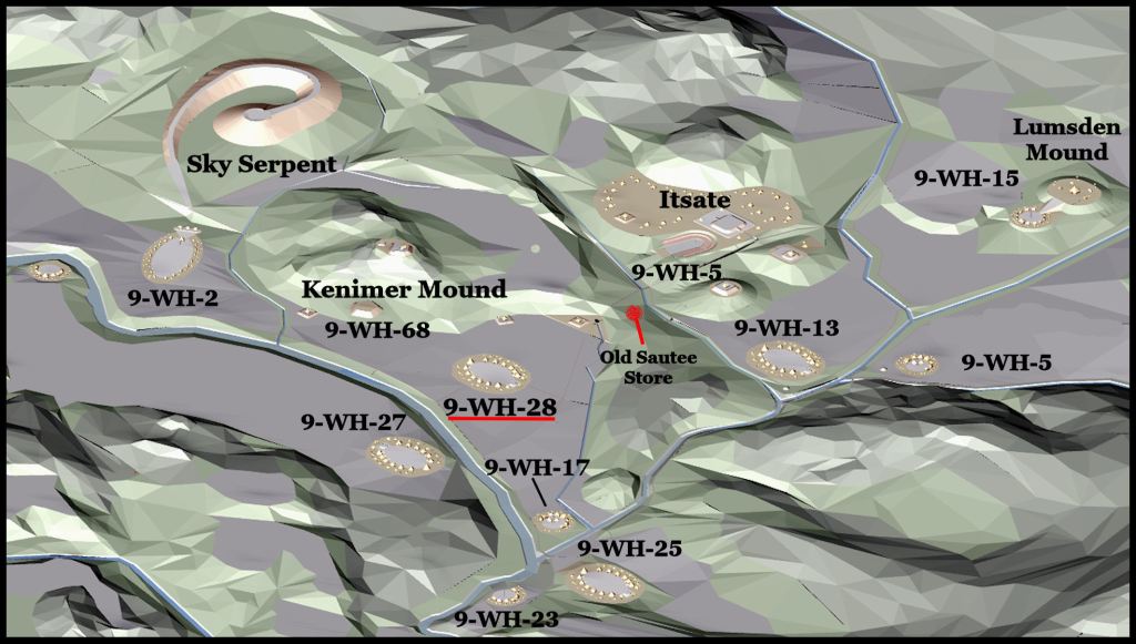
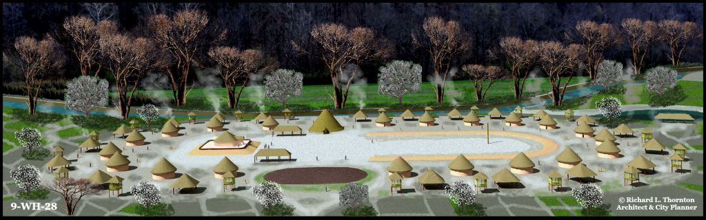
Above are village sites, mounds and earthworks with in .6 mile (1km) from the Old Sautee Store. This is just one neighborhood in a 12 mile (19.3 km) long archaeological zone. The population density in the Nacoochee valley from 1000 BC to 1700 AD was astonishing and conflicts with what is taught in North American anthropology classes. All of the oval and round village sites in this computer model contained artifacts going back to the beginning of the Woodland Period (1000 BC). Some contained artifacts from the Late Archaic Period (3,500 BC – 1000 BC).
Over time the plans of villages and neighborhoods in the Nacoochee Valley evolved. In the era of this site plan, the Late Swift Creek Phase villages, strongly resembled villages in western Tabasco and southern Veracruz during the Olmec Civilization. In the phase of development that came after the Years with No Summers, many villages in the valley, but not all, became almost identical to Itza Maya villages in central and eastern Campeche State, Mexico or rectangular houses in southern Veracruz or Chiapas. Even the architecture was identical. However, the Apalache elite continued to live in large round houses (much larger than these) until the late 1600s. They will be discussed in another article. Although inhabited at the same time, Site 9WH2 had Campeche style houses in the next phase, while 2,100 feet (640 m) to the east, 9WH28 had square houses, typical of the mountains between Oaxaca and southern Veracruz.
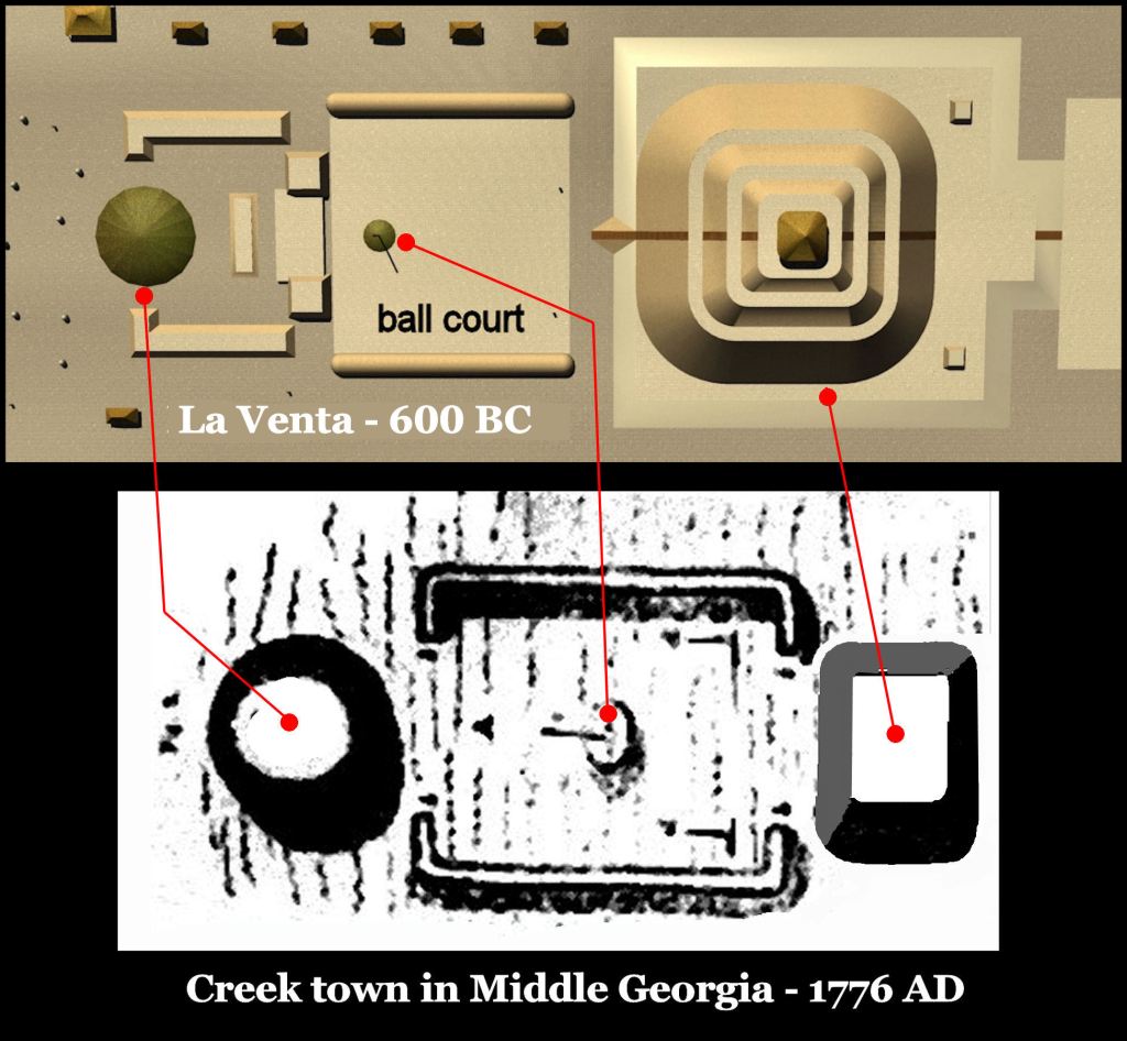
Creek towns in central and western Georgia continued to contain earthworks like the Olmec Civilization until after the American Revolution, when many Creeks were pushed into Alabama and Florida. When visited by William Bartram in 1776, the original site of the Creek capital town of Coweta had a layout like the great Olmec Civilization town of La Venta . . . 2500 years earlier!
The virtual reality image at top of article
I am portraying Middle Woodland Period (300 BC-540 AD) villages in the Nacoochee Valley as agriculturalists. There is no other way to explain the extremely high population density of the valley during that era. The Middle Woodland houses that Robert Wauchope unearthed at 9WH28 were identical to those at 9FU14 on the Chattahoochee River in southwest Atlanta near Six Flags Over Georgia. The Six Flags site was occupied from about 300 BC to 450 AD or later. Deep plowing had damaged the final occupation layer. Like 9WH28, 9FU14 contained a low, rectangular platform mound and an oval burial mound on the edge of the village. Excavation there was supervised by Dr. Arthur Kelly. It was my first exposure to archaeology. Oval burial mounds, covered with cobbles remained a tradition of the Apalache until the 1700s.
Dr. Kelly found circumstantial evidence of agriculture in the detritus accumulated under successive constructions of houses at 9FU14. There were numerous seeds of indigenous plants of Georgia, which are now considered weeds. His students also unearthed sunflower, Jerusalem artichoke, squash and primitive maize (Indian corn) seeds. What convinced Kelly of agricultural activities was the presence in that part of the Chattahoochee Valley of three types of indigenous sweet potatoes. Unlike South American sweet potatoes, they had a single, large tuber. These feral tubers were not as sweet as modern, commercial sweet potatoes from South American ancestors, but were mildly sweet and certainly edible.
Kelly was bitterly attacked by his peers for stating that agriculture occurred at 9FU14. They knew for a fact that agriculture jumped 1,700 miles from Central Mexico to Cahokia, Illinois in 1000 AD! They also knew for a fact that sweet potatoes were not grown in the United States until South Carolina planters imported them from South America in the early 1700s to feed their slaves.
Archaeology professors at the University of Georgia went rabid when that same year, Kelly announced in the Atlanta Journal, the discovery of pottery and figurines along the Chattahoochee River, which were either made in Mexico or copies of Mexican artifacts. He was forcibly retired from the faculty on December 31 of that year.
On January 1, I completed my Thesis-of-Intent to become the first recipient of Georgia Tech’s Barrett Fellowship. It was endorsed by Dr. Kelly. My research plan was to comprehensively study on site all Mesoamerican civilizations to determine any similarity between the indigenous architecture and town plans of Mexico and Georgia. Now you know!
What Dr. Kelly didn’t know! The Creek word for sweet potato, aho, is the same word used by indigenous peoples of northern and eastern Peru. However, the Southeastern sweet potato is genetically different than the South American sweet potato. The indigenous people of the Lower Southeast were cultivating, improving and eating sweet potatoes long before the arrival of 17th European century colonists.
What Dr. Kelly and his team from Georgia State University thought were wild weed seeds are now known to be crops grown by the indigenous peoples of the Lower Southeast. In the late 20th century, botanists studied such seeds found in archaeological sites and determined that they had been genetically altered long in the past. It is now know that selective cultivation of indigenous plants in the Southeastern United States began at least as early as 3,500 BC.
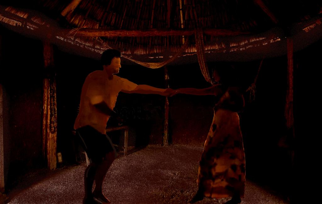
Curious as to why Georgia Creeks carry Panoan DNA from Peru, my research has discovered that Swift Creek style motifs and pottery originated long ago in Peru. Swift Creek and Napier style motifs are still used on Panoan clothing in Peru. In fact, the traditional clothing of the Panoans, Creeks and Seminoles are pretty much the same – long shirt, turban and beautiful polychrome dresses on the women. The Stomp Dance came from the Panoans. Other Panoan words found in the Creek languages include bean (talako), Yaupon holly & tea (ase), boat or large canoe (perro), ocean (para‘) and village chief (orata). There are probably many more, but I have not comprehensively compared Panoan and Creek dictionaries.

Archaeologist Robert Wauchope in the Nacoochee Valley (1939)
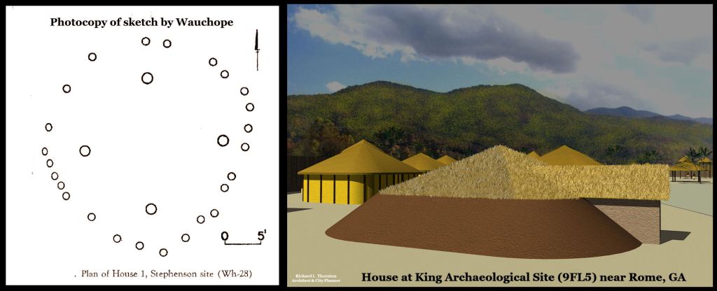
Wauchope’s initial full site investigation in the Nacoochee Valley was the Eastwood Village (9WH2), He then identified a five side earthen pyramid at the foot of Kenimer Hill, but did not have permission to excavate it. He then moved another 1000 feet eastward, where potsherds dotted the soil. This was the Stevenson Farm or Site 9WH28, where he did have permission to excavate.
Because the two sites were so close, Wauchope assumed that there was no need to fully excavate the second one. Trenches and pits that he dug at 9WH28 proved his assumption wrong. Although the two villages in close proximity and and inhabited concurrently for perhaps 2700 years, during several eras, the occupants were culturally different!
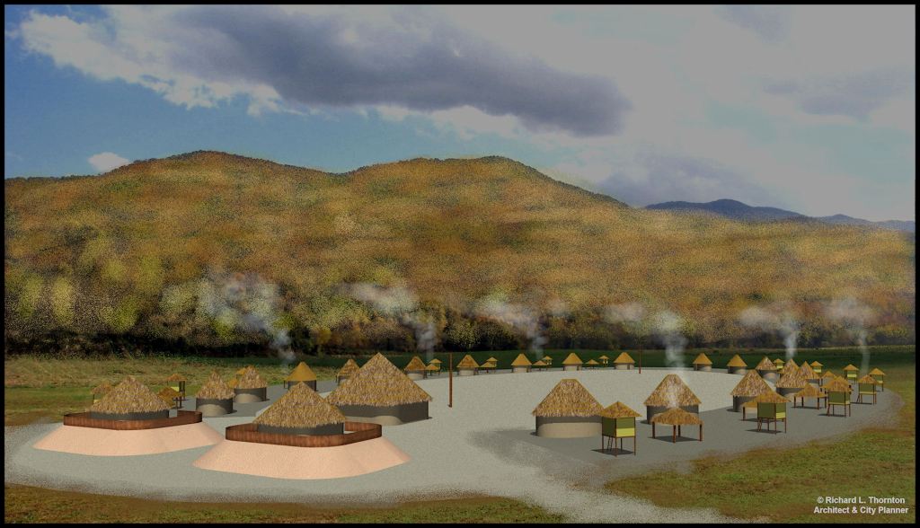
During the Middle Woodland Period (200 BC? – 550 AD) Site 9WH28 was probably the largest village in the valley, while 9WH2 appears to be a hamlet. During this period, both villages had round houses and produced Swift Creek style pottery. However, 9WH28 contained the widest range of pottery styles – ranging from the beginning of the Woodland Period to pottery typical of the Creeks in the late 1600s. There were also many styles of pottery, which Wauchope could not link to a known style in Georgia. They included a Post-Summerless Days style that was in the form of Woodstock pottery (800-1000 AD) but decorated with elaborate Swift Creek stamped motifs.
During the period from 600 AD to 1000 AD, 9WH28 and 9WH2 were probably about the same size. However, two mounds on the northwest tip of the 9WH2 village were developing over the burials of important leaders. The long axis of the oval village was oriented to the Winter Solstice Sunrise. The houses were oval and pretty much identical to houses in Central and Northern Campeche at that time. They were shaped like a medicine capsule. In contrast, the council house was square with four central posts.
Archaeological Site 9WH2 or the Eastwood Site around 800 AD
Thus, after 600 AD, 9WH2 or the Eastman Site had every architectural and urban planning trait of traditional Chickasaw culture. It is the oldest known Chickasaw village. Chickasaws continued to live in White County, GA until 1818! The tail of the massive, recently discovered Sky Serpent terminates about 100 feet (30 m) from these mounds . . . which were later enlarged to become one mound.
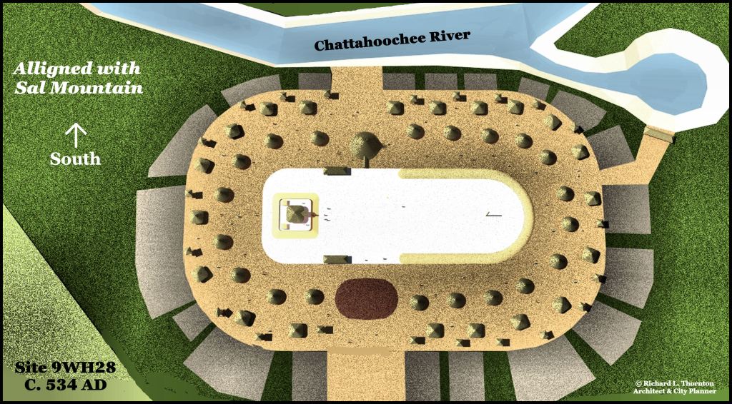
9WH28 was always oriented East-West. It had one platform mound on the east end and one burial mound on the side of the village. The houses were no longer round, but roughly square with vertical log interior walls and four support posts. The interior spaces were roughly 16-18 feet (14.8-5.4 m). These were obviously earth berm houses. Absolutely identical houses have been found on top of Browns Mount near Macon, GA, Bullard’s Landing near Warner Robbins, GA and at the King Site on the Coosa River, west of Rome, GA
In other words, these houses were identical to the earth berm houses, built by the Siouan “Earth Lodge” tribes such as the Mandan, Otto, Arikara, Quapaw, Kansa and Hidatsa. Up until the 1700s, these tribes lived in the Southeast. The Oto lived at Bullard’s Landing. Some of their villages joined the Creek Confederacy and moved to the Chattahoochee River. Others headed toward the Missouri River.
Robert Wauchope only carried out limited test ditches at 9WH28. I suspect that during the period after the Nacoochee Valley became thoroughly Mesoamerican in character, Proto-Creeks and Mesoamerican style houses became the occupants of this village site. However, without further archaeological work, this suspicion will remain unsolved.
Two funny stories about Robert Wauchope
(1) Sixteen-year-old Tom Lumsden was a laborer and water boy, employed by Robert Wauchope in the Nacoochee Valley. He went on to be the Valedictorian of Nacoochee Hign School, a medical doctor and a respected local historian. Tom repeatedly told Wauchope that there was a massive Indian mound in almost perfect condition on top of Kenimer Hill . . . which overlooks both sites 9WH2 and 9WH28. The first time he was told this, Wauchope looked up to see its silhouette through the trees. It seemed too large to be an Indian mound, but also Wauchope assumed that if was a mound, it would have been noted by famous archaeologists in the past such as Charles Jones, Cyrus Thomas and George Heye, who had explored the Nacoochee Valley. He never got around to climbing up that hill. Nope . . . to this day, the Kenimer Mound remains generally unknown to the public.
(2) In 1932, Robert Wauchope traveled to the Yucatan Peninsula to do research for his dissertation on Maya residential architecture. To journey in that part of the world in that time period would have been an extraordinary experience. Those of you, who have seen my videos on the fellowship in Mexico can see how primitive things were within the interior of Ythe ucatan Peninsula in 1970. In 1932, Wauchope’s travels would have been like going back in time 200 years. There were no paved highways or buses in Yucatan back then . . . and very few cars, even in the cities.
It appears that he did not travel in southern Veracruz, Tabasco and Chiapas states, where most of the ancestors of the Creek Indians came from. However, he did get down into northern Campeche, where the round-ended Maya houses were traditionally constructed. In 1938, his substantially expanded and refined dissertation was published as Modern Maya Houses, A Study of their Archaeological Significance. It is a masterpiece. His book was one of my most important references, while on my fellowship. It somehow got misplaced during the time period, I was in Sweden or getting started in my career . . . flying around on business trips as much as 14 times a month.
I assumed that Wauchope was an architect. The text is written in a straight-forward style, but contains all of the correct architectural terms. The illustrations are professional in quality. Either he had training in architectural graphics or the publisher hired an architect to illustrate the book. His book is still “THE” gold standard reference on historical and contemporary Maya residential architecture.
With all those superlatives in his credentials, it never dawned on Wauchope that several house plans that he drew while studying the archaeology of North Georgia were identical to houses that he studied in Mexico and Guatemala.
Wauchope frequently provided the Maya translation in the local dialect for components of the houses. He definitely traveled in parts of Guatemala, where a dialect of Itza Maya was spoken. YET, it never dawned on him to look up the meaning of Chattahoochee . . . the river that he worked beside for over a year.
Chattahoochee is the Anglicization of Cha’ta Hawche. Depending on the accent mark, it means in Itza, either “Carved stone” (stela) or “Ancient ruins” . . . shallow river. Ironically, Wauchope is best known nationally for his work in the lands of the Mayas.
Unlike Robert Wauchope, I learned about Maya houses the good ole fashion way . . . by dancing the night away inside an ancient Maya house near the ruins of Labna. Seriously, the eight days that Ana Rojas and I spent driving around the then Tierra Incognito of Eastern Campeche in Ana’s new Jeep, were magical. We both had just turned 21, but never forgot those happy days frolicking in the jungle and the ancient ruins. Although a rising senior in Highschool Education at the Universidad de Campeche, the experience caused Ana to shift directions. She earned a PhD in Anthropology at UNAM then went on to become an internationally recognized expert in . . . you guessed it . . . Maya music and dance. Well, she is 1/4th Maya, but tall like her mother.

Richard,
You should get some local IT grad students to run comparative word studies of the Panoan and Creek language dictionaries via artificial intelligence (AI) to see what can be rendered with respect to synthetic and phonetic similarities. It might be interesting, yet truly expansive to also incorporate European linguistics for any correlations as well.
It might be a task extrapolating that massive data set, but programs like ChatGPT might have resource banks available to parse and interpret that data rather quickly. It would be interesting to see AI correlations, but it may come up with some interesting and bizarre outliers as well.
R/,
Zac
LikeLiked by 1 person
None of the dictionaries involved are digitized. Also there are several Creek and Panoan languages. Another problem is that all the Panoan languages are paired with Spanish, not English. So my brain can read the Spanish meaning of the world (usually) in a book, but someone not familiar with Spanish would have a problem. So any analysis would have include five Panoan languages, four Creek languages, Spanish and English.
LikeLiked by 1 person
Hello – I came across a broken statue buried in my backyard that appears mayan. I have found a few other odd things and I have hundreds of bird and snake effigys. I see a lot of “V” on them. I never noticed before until I broke my leg and was homebound for 2 months. The statue was broken and used for the foundation of an old cinder block wall in the back. There is a lot of caliche and quartz in the yard and I have an old white oak that has markings in the front yard. There is another statue with birds I found but not sure if it’s Mayan. I emailed The Department of natural resources and UGA but didn’t get any response that helps with the direction I should take with this. I suspect there is something under my house and my neighbors home as well. My suspicion came from the way the water/sewer is connected. I have 2 hypotheses on how these came to be in my yard and not recognized. Some of the big placer stones resemble gold ores and I have a friend who wants to come and crush them to see. I’m trying to find information on how to proceed with these objects. This home has a history of having snakes and owls and more recently I have had a myriad of synchronicity with owls and snakes. I believe the small snake effigy’s are really fossilized/crystalised owl pellets. With that being said, what does one do with this stuff?
LikeLike