
It dwarfs the famous “Great Serpent Mound” in Ohio, which is 1,320 feet long. The Celestial Serpent has a tail that is 2,200 feet (671 m) long and up to 50 feet (15 m) tall. The head is 580 feet (177 m) in diameter. We continue to study this amazing structure without disturbing its current terrain.
by Richard L. Thornton, Architect & City Planner
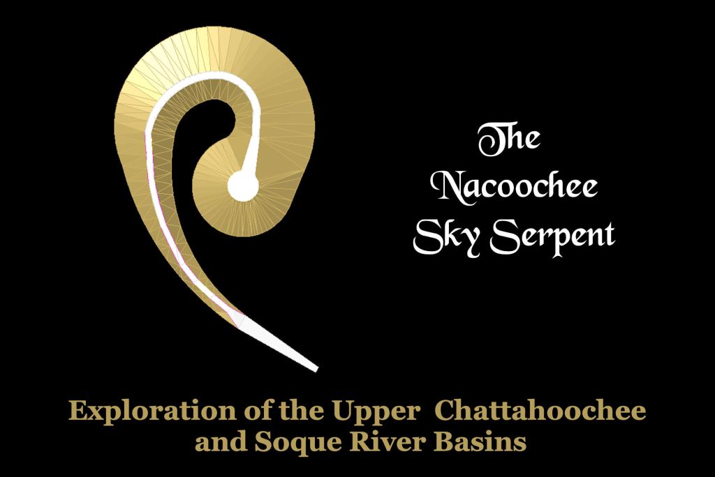
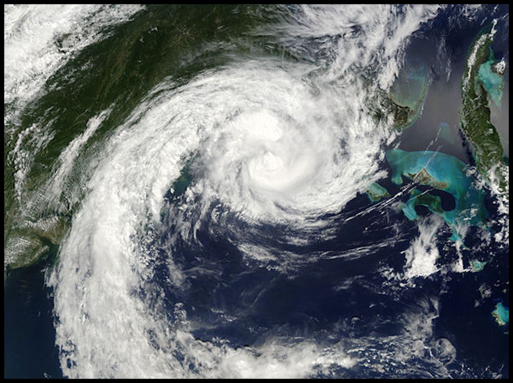
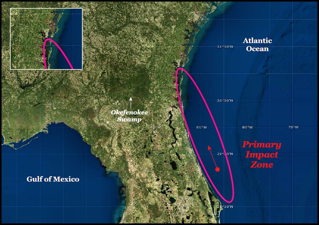
The shape of the Celestial Serpent is also identical to many hurricanes on the South Atlantic Coast.
Celestial Serpents
The indigenous peoples of southeastern North America and Mesoamerica believed that comets and meteorites were feathered serpent deity, which came down from heaven and landed on earth. Many times the larger comets or asteroids would spiral as they came through the earth’s atmosphere – hence the spiral being associated with serpent deity.
Some branches of the Mayas worshiped a Celestial Serpent as their principal deity. One of the many misconceptions about the Maya civilization held by most North Americans is that it was a monolithic culture in which all deities, political systems and architectural styles were the same throughout. That certainly was not the case.
A February 7, 2022 article, in Smithsonian Magazine by Elizabeth Gamillo described a devastating explosion in the skies above eastern North America “about 1500 years ago,” which was still remembered by several Midwestern indigenous peoples. She was not aware that several researchers, including myself, had much more specific information about this devastating impact, including the actual year and location of the main body of the asteroid or comet. Nevertheless, the descriptions provide us a greater understanding of the form of the Celestial Serpent.
Quoting Gamillo . . . “What’s fascinating is that many different tribes have similar stories of the event,” says University of Cincinnati anthropologist Kenneth Tankersley, who is a member of the Piqua Tribe of Alabama. “The Miami tell of a horned serpent that flew across the sky and dropped rocks onto the land before plummeting into the river. When you see a comet going through the air, it would look like a large snake. The Shawnee refer to a ‘sky panther’ that had the power to tear down a forest. The Ottawa talk of a day when the sun fell from the sky. And when a comet hits the thermosphere, it would have exploded like a nuclear bomb.”

The Sandia Laboratory in New Mexico determined that a large comet striking Earth creates a massive, super-heated shock wave that could kill all life long distances “down stream” from the primary impact zone. The 539 AD impact could have wiped out most of the human population in northeastern Florida, eastern Georgia, western South Carolina and western North Carolina.
1014 AD and 539 AD impacts
Although some of the pottery found at the Track Rock Terrace Complex (Woodstock and Napier) dated from the Late Woodland Period, the oldest radiocarbon date found in three test pits dug at the Track Rock Acropolis was approximately 1018 AD. This is significant, since there were enormous tsunamis created in the North Atlantic Ocean by the impact of multiple objects in 1014 AD. Over 200,000 people were killed in western Europe by the tsunamis. The worse damage was done on the shores of eastern North America. The coastal terrain as far south as Cape Hatteras was altered . . . with many islands either being created or permanently destroyed.
Once ice cores in Greenland and Iceland had revealed a massive spike of atmospheric ammonia levels in 1014 AD, scientists decided to go further into the past. It has been known since 2010 that massive volcanic eruptions during the 530s AD in Mexico and Iceland left large level of trace minerals in the Arctic ice sheet. This caused the scientists to originally miss something else going on in 539 AD.
In 2013, Dr. Robert Dull of the Environmental Science Institute at the University of Texas in Austin announced results of tests, which indicated that the Ilopango volcano in El Salvador kicked off a period of cooling in the world’s climate. In 536 AD at least two large volcanoes also erupted in Iceland. For decades afterward a bluish haze over the northern hemisphere and tropics caused famines and probably a horrific plague. There was another layer of chemical deposits that came soon after, which Dull missed. You will learn about them below.
The 539 AD tsunami ridge
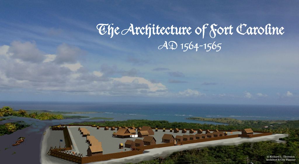
I made a fascinating discovery, while doing research in 2013 on the Georgia Coast for my book, Fort Caroline . . . The Search for America’s Lost Heritage. Ten years later, it would have a direct connection with the Nacoochee Celestial Serpent.
In 1564 French Captain René de Laudonnière became entranced with a hill or ridge that he called “his modest mountain,” while exploring the South Atlantic Coast for a location to establish a colony. The hill was apparently about 10-11 miles inland, since he selected a spot for a fort nearby that was that distance from the ocean. De Laudonnière stated that from the top of the hill, he could see across the broad bay created by the May River to the edge of the ocean. That means that the hill was at least 80 feet high.
There is only one location possible for Fort Caroline. This is 11 miles inland on the Altamaha River in Georgia, where an 80-85 feet high ridge is pierced by the river. It is where all maps up to 1793 showed Fort Caroline to be located. Afterward, the fort’s ruins are not mentioned.
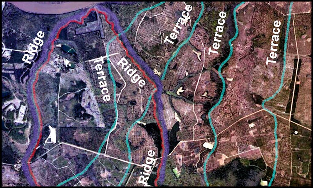
As can be seen in the infrared image, many of the ridge patterns are very different than the vestiges of high ocean levels. Individual sections of these relatively high bluffs and ridges are identical to that of the impact of the 2005 tsunami on the coastal region of northwestern Sumatra and the 2011 Tōhoku tsunami on the coastal region of northeastern Japan. Both of these tsunamis were caused by earthquakes under the ocean. The debris pile left by retreating waters left ridges of sand, muck, vehicles, houses and trees.
In 2009, Dallas Abbot of Columbia University found nodules associated with a major asteroid or comet strike at the “500s AD level” of the Greenland Ice Shelf. She insisted that either a comet or asteroid played a role in the climatic catastrophe. In 2010 a Greek archaeologist, Dr. Amand Laoupi, reinforced Abbot’s theories by revealing a second ammonia spike in the Arctic ice shelf in 539 AD that Robert Dull had missed. The spike was clearly unrelated to Icelandic volcanic activity.
There is type of geological formation on the South Atlantic Coast that has scarcely been noticed by geologists, or else been lumped into the category of “ancient coastal islands,” without much serious thought. Beginning around Port Royal Sound, SC and continuing southward to St. Augustine, FL are a chain of tall ridges and hills that become increasingly tall and farther from the coast until they reach the center point of the chain on the Satilla River in southeastern Georgia. Unlike all the other sand formations, these ridges vary from being almost perpendicular to the coastline to diagonal to forming U-shaped enclosures. The highest one, near Woodbine, Brunswick and Darien, GA is 80-85 feet (+/- 26 m) tall.
Mechanics of Deformable Bodies
Suspecting that the ridge along the Georgia coast could tell me where the comet struck the South Atlantic Coast, I applied the branch of physics used by structural engineers and architects to design structures. The Coastal Regional Commission in Darien, GA gave me a copy of their LIDAR scans for the Georgia Coast and northeast tip of Florida. There were big surprises.
Although most visitors to the Georgia coast think of it as being pancake flat, there is an undulating ridge up to 85 feet tall that snakes its way down the coast. The tallest section of the ridge is also the farthest inland – 85 feet above sea level and 16 miles inland. This is the section between the Satilla River and just north of the Altamaha River. In northeast Florida, the ridge is fragmented, from 25 to 45 feet high and a maximum of six miles inland.
There was something very different about the overall pattern of these ridges on the South Atlantic Coast. Some massive force had pushed sediments from the bottom of the ocean over 10 miles farther inland near Woodbine, GA than at Jacksonville. The alluvial pile was also 90% higher near Woodbine and 10.5 miles farther inland. Woodbine, GA is 50 miles north of Jacksonville. This suggests a “point source” for the tsunami rather than the linear source that is typical of under ocean landslides and earthquakes.
The curvilinear pattern of the high ridges on the South Atlantic Coast most closely resembled the impact of an artillery shell on mud. The impact crater forms an ellipse, with the highest walls of mud kicked up on the side of the ellipse that marks the direction of the artillery shell’s flight. A massive “artillery shell” from space had struck the Atlantic Ocean at an acute angle.
In plan, the coastal ridge looks exactly like the debris ridges left by the tsunami’s on the coasts of Sumatra and Japan, except in Georgia the ridge is much higher and farther inland. The sections of the ridge immediately south of Savannah and Jacksonville were the closest to appearance scale of these recent tsunamis.
I was puzzled. Absolutely nothing in geology textbooks or websites mentioned a large asteroid or comet striking Georgia and Florida. Even today, the standard references tell you that the Georgia coastal terrain was created by the rise and fall of ocean levels over the eons, however . . .

Geologists simultaneously make discoveries
When a large meteor, asteroid or comets strikes the ocean, intense heat and mechanical energy, plus several gases are released into the atmosphere. These gases are trapped in the Arctic and Antarctic ice caps. Volcanic eruptions leave several chemical traces in the ice caps; primarily sulfates. There was an enormous ammonia spike in 539 AD and 1014 AD. Volcanoes do not emit ammonia.
In 2013 two scientists in Japan, Haruna Sugahara and Koichi Mimura, finally answered the question of whether the catastrophic strikes in 539 AD and 1014 AD were meteors or comets. It was already known that comets were essentially dirty ice balls that contained the type of debris which could become the type of nodules that Dallas Abbot had found in several locations along the Atlantic Coast.
In 1994 chunks from the Shoemaker-Levy Comet crashed into Jupiter, creating massive explosions, visible on earth. The largest explosion was the width of the planet Earth. The Japanese scientists’ analyzed the electro-magnetic waves emitted by these explosions. Shoemaker-Levy contains large amounts of frozen ammonia. A super-sized comet striking the Atlantic Ocean could have both caused gargantuan shock waves and filled the atmosphere with ammonia.
Several of the geologists, who studied the effects of the 1014 AD comet impact, stumbled upon identical evidence for an even larger impact farther south in the Atlantic around 539 AD. Since all of the academicians worked at universities in the Northeastern United States or in the UK, little further study was done. The news of this earlier impact apparently has not reached most anthropologists in the Americas. The European anthropologist, who co-authored one of the articles on the 539 AD event in a journal for geologists, merely stated that the impact zone was “probably somewhere in the northern Caribbean Basin and may have contributed to the known cultural hiatus that occurred in Maya city states in the mid-500s AD.”

Was the Nacoochee Valley also struck?
Extend a line northward through the centroid of the ellipsoid impact zone of the 539 AD comet and you cross the Nacoochee Valley. This makes me suspect that the original bullseye-shaped terrain from which the Celestial Serpent was sculptured, was created by a fragment of the comet. Alternatively, it may be from an earlier impact.
Whatever the origin of the unusual natural formation, it is quite likely that Itza Mayas traveled northward after the arrival of a Great Celestial Serpent in 539 AD and sculptured an earthen shrine to it. The construction of Campeche Maya style houses at archaeological site 9WH2, the town site at the tip of the serpent’s tail, AND of the Kenimer Mound, immediately to the east, have been estimated by archaeologists to be around 600 AD, but could well have been a few decades early. The timing seems to be no accident.
