Because both the U.S. Department of Interior NAGPRA Map and official state history books pretend that the Chickasaws never lived in the Southeastern United States, one has to talk with tribal scholars, examine Colonial Period archives and read the archaeological reports of Robert Wauchope . . . to get the facts. The irony is that Chickasaws living where Wauchope made his discoveries, were not forcibly removed in 1818. Many seemed to have just blended into the mainstream population of Northeast Georgia or moved to recently ceded Creek areas of Alabama.
Chickasaw scholars will tell you that their ancestral villages eventually spread over much of the interior of the Southeastern United States, reaching as far east as western South Carolina and as far north as southwestern Ohio . . . carrying with them sophisticated concepts of agriculture and architecture. Indeed, the Simpson’s Field Village Site in Anderson County, SC has long puzzled South Carolina archaeologists. The houses were like those I slept in, while on my fellowship within the interior of Campeche. There was evidence of extensive agriculture, probably including Indian corn. Yet, the radiocarbon dates were c. 600 AD – 800 AD. That seemed impossible.
by Richard L. Thornton, Architect & City Planner
SLIDE SHOW
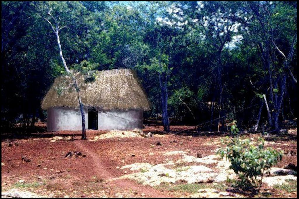
One of the houses, where Ana Rojas and I stayed, while exploring the interior of Campeche
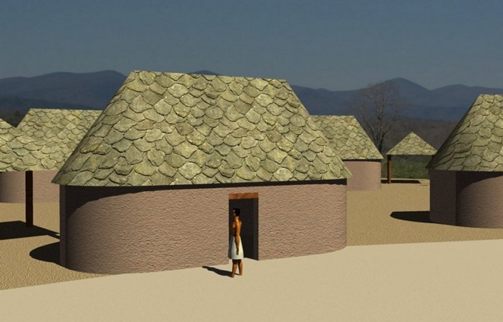
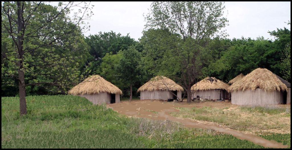
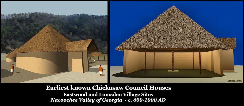
House at the Lumsden Village in GA and the Simpson’s Field Village in SC
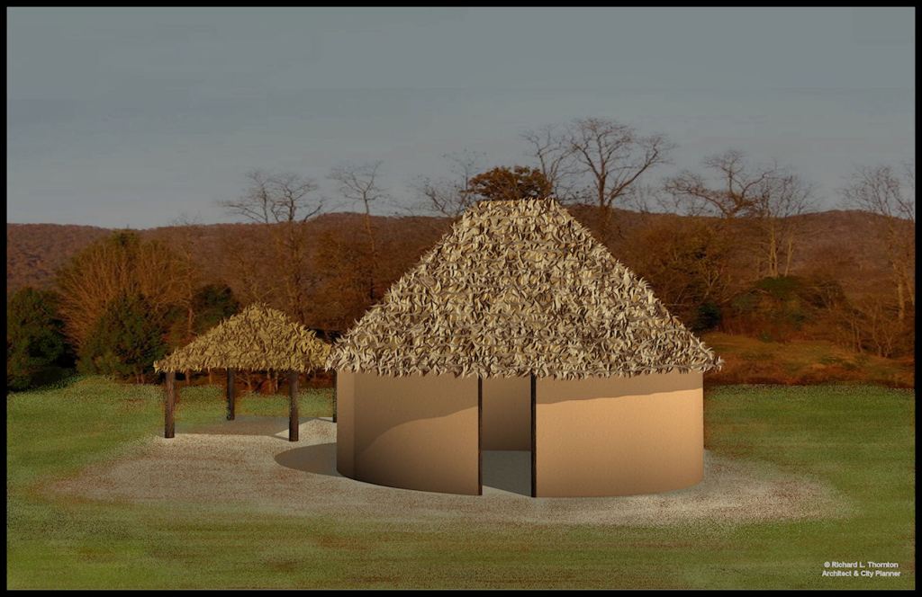
House at the last stage of the Eastwood Village Site
Chickasaw Heritage Village in Oklahoma
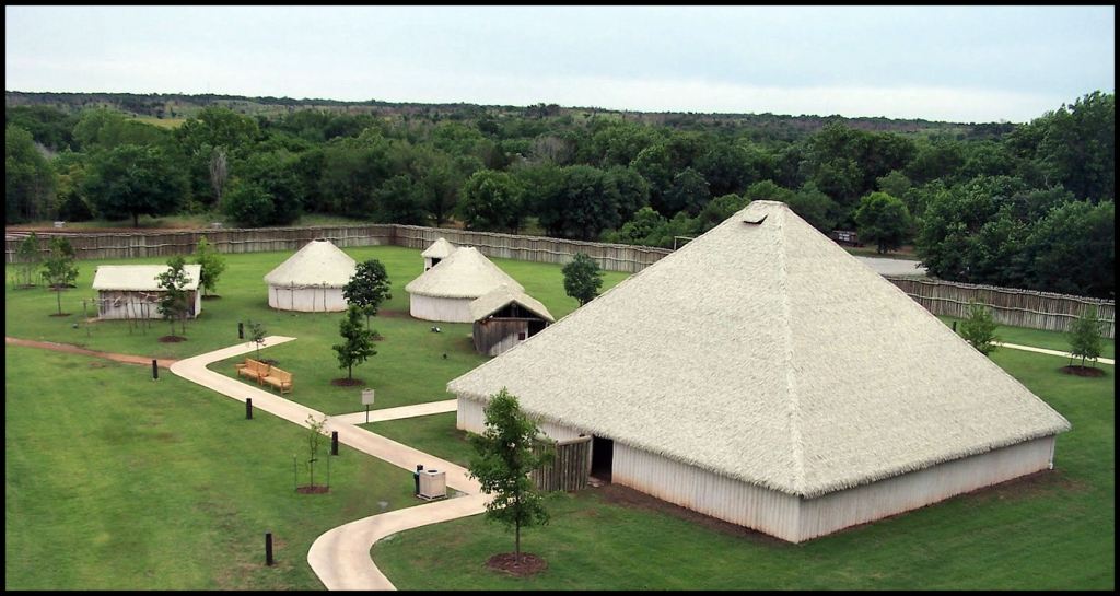
Traditional style conference center of the Chickasaw Nation – Oklahoma
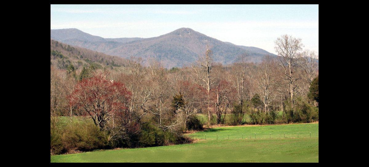
Robert Wauchope in the Nacoochee Valley
In 1938, Robert Wauchope completed his dissertation on Mayan residential architecture and received his PhD in Anthropology from Harvard. That same year, the dissertation was published as a book by the Carnegie Institute. It instantly made Wauchope a nationally recognized expert on Maya vernacular architecture . . . a reputation, which he maintained his entire career.
His book was one of my most important references, while on the fellowship in Mexico. Unlike any other archaeology book, I have ever owned, it is filled with architectural drawings and details of a quality equal to that done by a professional architect . . . or perhaps a skilled architecture student. This valuable resource went missing from my parents’ house during the period, when I was working in Landskrona, Sweden then Columbia, Maryland.
Earlier this year, I found a copy of his book in . . . of all places . . . India. That book was one of my first purchases, when I received the first grant from the organizations in California and Campeche. The acquisition was expensive, but worth every penny in my current line of research.
In 1939, Wauchope was hired by the WPA to carry out an archaeological survey of northern Georgia and simultaneously become the first ever anthropology professor at the University of Georgia. Although he had grown up in Columbia, SC, Wauchope was not prepared for the high Pre-Columbian population density in northern Georgia and for towns that had been occupied for as long as 2500 years. Well, the chroniclers of the De Soto Expedition did say that the conquistadors never lost sight of houses or cultivated fields, while traveling through what is now the State of Georgia.
Wauchope was allotted a year, but spent most of that year in the Nacoochee Valley and the section of the Chattahoochee River, from Atlanta northward. He could have spent several years just in the Nacoochee, but because he did not even go into many of the counties, under his assignment, he missed dozens of large, long occupied town sites in other river valleys and all of the stone-walled terrace complexes. He even missed several large town sites with huge mounds in or near the Nacoochee Valley. They were so large that Wauchope assumed that they were natural hills . He did not enter Georgia again for 20 years and did not publish his report until 1966.
No evidence of Cherokee occupation
Initially, Wauchope entered the Nacoochee Valley, thinking that he was going to fill in major gaps in Cherokee history. No Southeastern map before 1715 even mentioned the Cherokees. The truth was that mid-20th century Cherokees had very little real knowledge of their past, prior to the Trail of Tears.
Wauchope initially discovered that the Native American artifacts in the Nacoochee Valley were almost identical those found a few years earlier at the Ocmulgee Plateau, near Macon, GA. There was a record of human occupation going back to the Ice Age . . . including 35 Clovis points being accidentally discovered. He soon discovered that during the Woodland, Mississippian and Early Colonial Periods, the Valley was essentially a megapolis with dozens of towns and satellite villages (neighborhoods) in close proximity to each other.
Near the top of the archaeological record were increasing percentages of late 16th century and 17th century European-style artifacts mixed with Lamar Culture (Proto-Creek) artifacts. Some catastrophe had deposited from 5 to 15 feet ( 1.5 to 4.6 m) of alluvial sand on the valley floor. Afterward only a thin scattering of 18th century European artifacts was intermittently unearthed. All the Native American towns were abandoned. The beginning in 1828 of the Georgia Gold Rush was announced by a 19th century American detritus of mining tools then farming tools and domestic artifacts.
Wauchope searched for a year, but could find no Cherokee village, Cherokee house or Cherokee artifact in the Upper Chattahoochee River Valley. The Cherokee Tribe might have owned the Nacoochee Valley from 1785 to 1821, but there is no evidence that any ethnic Cherokee ever lived there. Nevertheless, the Georgia Historical Commission erected a grossly inaccurate sign in front of the Nacoochee Mound, stating that Cherokees built it and were occupying the surrounding town, when Hernando de Soto came through in 1540.
Linguistic analysis
Early maps revealed that even during the Cherokee ownership of the land, all towns and villages had Itza Maya names. What is now Helen, GA was named Chote . . . a Maya tribe in Tabasco. All rivers and streams had Itza Maya or Soque-Mixtec names until the advent of the Gold Rush. The Upper Chattahoochee was named the Chote River until 1832. Where it joined with the Sokee River in southern Habersham County, the name changed to Chattahoochee . . . but Chattahoochee is the Anglicization of the Itza words Cha’ta – Hawche. (Stela or carved stone – shallow river) There was a Chickasaw village on Itsate Creek, south of Nokose Mountain, also named Nokose . . . which is “bear” in both Chickasaw and Creek.
The 1832 US Congress Map of the Georgia Gold Fields labels Mount Nokose as being Yeona Mountain. Yeona is the Asturian (NW Iberian) word for mountain lion. The next official map of Georgia labeled Nokose Mountain as being Yonah Mountain, a Cherokee word now used for the Grizzly Bear.
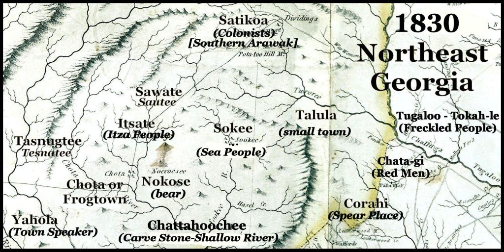
On the official 1830 map of Georgia, all but one of the Native American villages in Northeast Georgia had Itza Maya or Creek names- mostly Itza. There was one Arawak village. Yonah Mountain was named Nokose, the Chickasaw and Creek word for bear.
A legion of references and Cherokee tribal spokespersons tell you that “the ancient homeland of the Cherokees in the Georgia Gold Belt was stolen from them, when gold was discovered.” Not true. The Cherokees did not own the land south of the Tallulah and Hiwassee Rivers in Georgia until 1795. Until 1818, the land south of Yonah Mountain was the territory of the Creek Confederacy and occupied by Chickasaw members of that confederacy.
The Nacoochee Valley was legally bought from its handful of “Native American” occupants in 1821 by a real estate speculator from Burke County, the gold-mining region of North Carolina. Most of its original Caucasian-American settlers, thereafter, were from Burke County.
Many residents in the region, who always stated that they were descended from a Cherokee Princess, are discovering that they carry no Native American DNA and that their fabled ancestor was either a Sephardic Jewish Princess or an Asturian Princess. Some DNA reports call her Portuguese or northwestern Iberian. Asturias was the principal gold-mining region of the Iberian Peninsula.
Tama is the Totonac, Itza Maya, Eastern Creek and Miccosukee word for “trade or commerce.” It is the Chickasaw word for a “town” . . . the place where that commerce occurred.
Lumsden Farm (Site 9WH5)
Sixteen-year- old Tom Lumsden was one of Wauchope’s laborers. His parents invited the archaeologist to study the “mound” on their farm, which was located between GA Hwy. 255 and Chickamauga Creek, about a half mile north of the Sautee-Nacoochee Community Center – then Nacoochee High School.
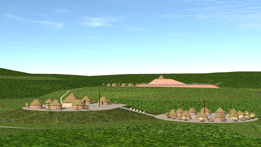
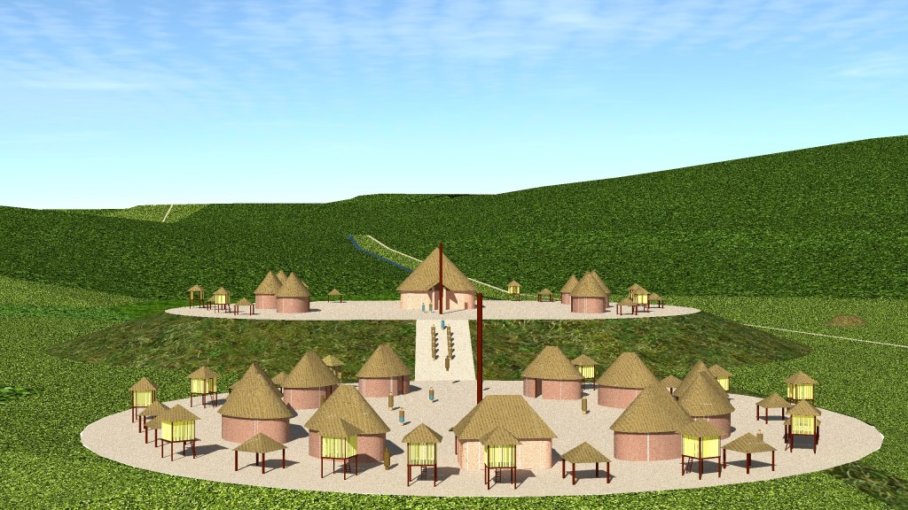
The mound turned out to be a natural hill groomed into the shape of a Meso-American platform mound. It was leveled at the top then the fill dirt was applied to the sides and to create a ramp. A square communal building and the largest houses were on the cap of the sculptured hill. Smaller houses encircled a plaza at the base of the ramp. Like the oval houses in Campeche, there were no columns within the floors of the houses. He could not find the hearths in several od the houses.
Wauchope interpreted these features as indicating that the elite families lived on top of the earthen structure, while families of lesser status . . . perhaps the soldiers, who guarded the king . . . lived at the foot of the mound.
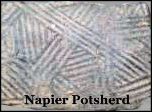
Radiocarbon dating had not been invented in 1939, but the chronology of pottery styles found at the Lumsden Site give a fairly accurate chronology for the town sites. The earliest pottery on the site is the Napier Style. The earliest examples of Napier date from the latter half of the 500s AD. In the Upper Georgia Piedmont Napier replaced Swift Creek Style and usually appears in new town sites.
Swift Creek villages, completely disappeared in southeast Georgia, which would have been devastated by the 539 AD comet strike off the coast of Cape Canaveral, Florida. The comet was traveling at an angle directly pointed at Southeast Georgia. Much of that region would have been inundated by a 120 feet (36.6 m) tall tsunami!
This royal village maintained the same Campeche-Chickasaw style architecture throughout its 1100-year occupation. Its pottery, however, evolved into the other styles that developed later in northern Georgia. The later styles of pottery were Woodstock, Etowah Complicated Stamp, Etowah Smooth, Lamar Complicated Stamp and Lamar Bold Incised. The relative proportions of the different pottery styles showed that the village was essentially a shrine in the early centuries, but it grew rapidly during the last two centuries of its occupation. This is when the Kingdom of Apalache’s capital was in the Nacoochee Valley.
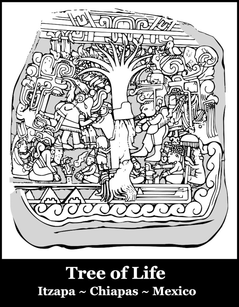
Wauchope was particularly fascinated with the communal building or temple. It had a large, single, column in the center, which rose out of a large clay hearth. Apparently, the lower section of the column was protected from the fire’s heat by a coating of clay. It was probably carved with ornate details, but all of the wood had disintegrated into black soil by the time Wauchope unearthed the building’s footprint. Four smaller columns helped support the roof.
The single large column in the center of a public building is a hallmark of Itza religious architecture. The column represented the World Tree, which held up the sky and dates back to the early days of the city of Itzapa (Itza-Place of) in the highlands of Chiapas. Itzapa was occupied from around 1500 BC to 1200 BC. It was originally the capital of the Itzas, but after they immigrated out of the region, their allies, the Soque, occupied and expanded the town. Yes, this is the same Soque as in the Soque River in NE Georgia.
The chronology of the Lumsden Village fits perfectly into the known history of the Itza Mayas in Campeche. Now that scholars can read the Maya glyphs, we now know that after the comet explosion in the sky in 539 AD and the eruption of several super-volcanoes to the south and in central Mexico, Campeche lost about half its population, when most of the Itzas migrated northward. They founded Chichin Itza, but that does not begin to account for the large number of people involved. Evidently, they continued northward to Florida and then to the Georgia Mountains. For unknown reasons, they evidently decided that the Nacoochee Valley was the home of he Sky Serpent deity. They mixed with other peoples to become several federally-recognized tribes today.

Speaking of the Cherokee Princess and her descendants who were not any such thing, Kurimeo Ahau has some astounding YouTube research videos about the Sephardic Jews who came to America and interacted with the Indians. Who knew!?
I really enjoy learning from your research, which is fascinating to me.I live in N Georgia, Hall County. Sincerely, MB~
LikeLiked by 3 people
Ahau is the word for Lord or Nobleman in Itza Maya. I lived on the north side of Gainesville from age 8 to 12. I attended Enota Elementary then Gainesville Middle School for a couple of months before we moved to Metro Atlanta.
LikeLiked by 1 person
Richard,
Thanks for the Chalaqua reference, if any tribe seems to fit the sneaky pete billet of Cherokee, it might be a spinoff of the Chalaka who were a spinoff of Shawnee confederacy.
The French recognized the Les Ci-ca-ca in 1684, just west of what the Mississippi River at this time.
Also note recognition of Apalatche as well with no distinct Cherokee. If Apalatche is closer to Helen, GA, The Tchalaka are located North of Apalatche. Between two rivers near mountains.
I certainly agree, there is truly not much evidence of the magical band apart, the Cherokee, especially where you would have originally expected to find them, if they “inhabited” the area for thousands of years.
The whole Holston area would place the Chalaka tribe closer to Knoxville, TN/North Carolina border region, or maybe a little further west of Knoxville as well in the Cumberland Region near Crossville, TN on the Cumberland Plateau with not much in between recognized by the French, other than as Chalaqua or Tchalaka as on the following map.
https://www.loc.gov/resource/g3300.ct000656/?r=0.408,0.414,0.173,0.235,0
https://en.m.wikipedia.org/wiki/Hathawekela
So at least in the 1680s, a branch of Shawnee confederacy in the midst of the Cumberland Region, Tchalaka …a tribe apart can be seen North of Apalatche, probably closer to modern day Knoxville, TN.
At the right place at the right time, preparing to fight Yuchee? Sounds like typical Cherokee folklore, these must have been descendants/ or the Cherokee age just a spinoff tribe of Tchalaka, with good fairy tales and pipe dreams of occupying a vastly unoccupied area in 1684. It would not surprise me if Cherokee descended from Chalaka, and/or remained in the area.
R/, Zac
LikeLiked by 2 people
https://accessgenealogy.com/native/really-cherokees.htm
I found this a pretty interesting read.
R/, Zac
LikeLiked by 2 people
Thank you! I wrote the article.
LikeLiked by 2 people
Thanks Richard,
I saw you wrote it, and appreciated your research and detail. John Ross’s father was Scottish, maybe that’s why John appeared to look a wee non-Cherokee.
R/, Zac
LikeLiked by 2 people
Another great dive into the many connections lost, and found, along with correcting either badly represented history or intentional, one. Special thanks to your noting of the comet that hit near Florida & Georgia. Was this event responsible for the tsunami that hit Sapleo Island and wiped every living thing off of the island or was that sometime later? It’s been several years since there.
LikeLiked by 1 person
Same comet. The tsunami debris ridge stretches from south of the St. Johns River to Savannah. The debris ridge is still 85 feet west of Dairen. I calculated the location of the strike by plotting the ellipse shape of debris ridge. This comet is the reason that there are no islands off the coast of Florida, until you get near Miami. The original outlet of the St. Johns River was near St. Augustine, but it was blocked by the impact rings.
LikeLiked by 2 people
Fascinating. Good homework as always sir! That’s interesting! How do you feel this fits into the Bimini Road aspect if at all?
LikeLiked by 1 person
I don’t think that there is a connection – different time periods.
LikeLiked by 2 people
Thank you
LikeLiked by 1 person
OMG ! this is so interesting Richard. What a shame you lost your book. Your thorough research is to be commended and I thank you for sharing. Have a great weekend.
LikeLiked by 1 person
Yes, but I got another copy. Actually, I calculated inflation between spring 1970 and spring 2023. The book cost me less the second time around, even when shipping costs from India were figured in. LOL
LikeLiked by 1 person
Good morning Richard. If it is not too expensive I would love a copy of Robert Wauchope book, Can you tell me the title and the cost please ,also where I can get it from. Best wishes Rita
LikeLike
Since you are in Crete, the shipping costs will probably be much lower from India. I didn’t know the name of the publisher in India, until I received the book from its rep in the USA, Abebooks. The India publisher is “Skilled Books” , Their book number is 10-LB100157353752-481-2-ku. The book is: Modern Maya Houses. A Study of Their Archaeological Significance by Robert Wauchope (1938). The India press’s copies of the images are of poor quality toward the end of the book, but good enough for me, since I have seen the real thing.
Of course, a modern Maya house in 1938 would have been pretty much the same thing as a Maya house a thousand years earlier. The book was particularly valuable to me since I quickly realized that most stone, monumental structures in Campeche and southern Yucatan were merely stone interpretations of wooden architecture.
LikeLike