
In 1565, Spain sought to subjugate the indigenous peoples of the Southeast by building a network of forts and missions along the Atlantic Coast to deep within the continent’s interior, Despite utilizing three times the number of conquistadors, who conquered the Aztec Empire, things did not go as planned.
Documents at the Archives of the West Indies in Seville, Spain has made it possible to reconstruct the probable appearance of these forts.
The Apalache Research Foundation, Inc. was established in 2014 to locate, document and preserve the forgotten Pre-Columbian and early Post-Columbian architecture of the Southern Highlands of the United States. We unravel mysteries from a Native American perspective. Our 2023 research focused on the secret histories of the Georgia and California Gold Rushes.
All virtual reality images were created with BricsCAD & Artlantis architectural softwares. The image above features the authentic appearance of a Spanish Colonial Cavalry officer in the 1560s, riding an Andalusian steed. During warmer weather, the officers in the Americas only wore leather armor like the enlisted caballeros.
by Richard L. Thornton, Architect & City Planner
+
Who was Captain Juan Núñez Pardo?
Pardo was captain of the Spanish Army garrison at Santa Elena on Parris Island, SC from mid-1566 till mid-1569. In that era, the army rank of captain was equivalent to the naval rank of captain. Virtually nothing is know about Pardo before or after that time period. Scholars do not know when he was born or when he died. However, he remained a prominent and respected person because he was buried in the north arm of Igrexa de San Francisco . . . Betanzos, Provincia da La Coruña, Galicia, Spain. Strangely, there is no date of birth or death on the sarcophagus.
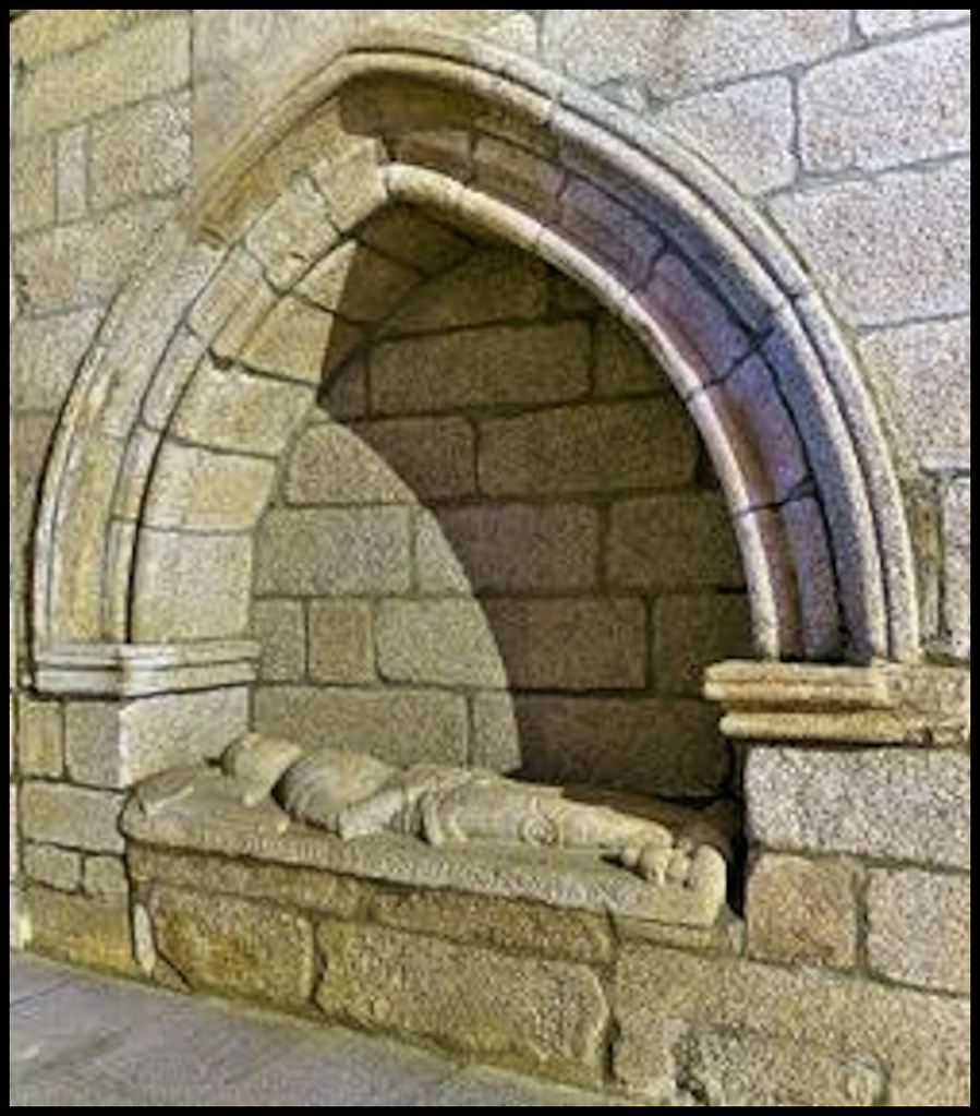
Sarcophagus of Juan Pardo
That we know anything about Pardo is because Governor Pedro Menendez appointed Licensiada (college graduate) Juan de la Bandera as Pardo’s notary and adjutant. Apparently, Pardo only had a minimal command of writing. De la Bandera kept a detailed journal of their travels, which was submitted to the Viceroy in Havana and King Phillip II in Madrid.
After finishing construction on a coastal fort and constructing a smaller, infantry fort, Pardo was ordered to find the closest route from Santa Elena to the silver mines in Zacatecas Province, Mexico.
Santa Elena was only about 40 miles (64.3 km) northeast of Savannah. A team of North Carolina academicians in the early 1980s concocted the idea that Pardo marched northward 325 miles (523 miles) in late autumn of 1566 to a dinky village site with at most, two dozen houses and a one meter tall mound in central North Carolina, in order to reach Mexico.
It is called the Berry Site and one of the houses did contain Early Colonial Period European artifacts. It is possibly one of the missions that Pardo established, but definitely not on the road to Mexico! LOL
The next year, Pardo and a company of his conquistadors made a much longer looping journey through the Southern Highlands. He directed the construction of at least five permanent forts, plus established mission stations.
Academicians in the De Soto-Pardo Routes Committee visited my office in Asheville, NC when I was Director of the Asheville-Buncombe County Historic Resources Commission. They were in Asheville to pick up big checks from the Biltmore Estate and Asheville Chamber of Commerce and announce that De Soto and Pardo spent the night in Asheville. An archaeological dig in 2000-2001, proved they didn’t. The professors’ proposed routes for Hernando de Soto and Juan Pardo were determined by placing masking tape on state highway maps, while they were sitting at their university desks.
None of these professors could speak Spanish or even pronounce Spanish words properly. Of course, being PhD’s in Native American anthropology, the professors knew diddlysquat about the Muskogean family of languages. They repeatedly insisted that town names, visited by De Soto and Pardo, with names easily translatable by Muskogean dictionaries, were, “Ancient Cherokee words, whose meanings have been lost.”
At that point in time, they had not visited any of their “set in concrete” sites for forts built by Pardo. In fact, most of the locations for Native American towns and Pardo’s forts, listed by Wikipedia, have any similarity to the indigenous ethnic identities and terrain, described by Juan de la Bandera.
There were several large Native American towns on the Wataree River that match De La Bandera’ s description Watari, but they are in South Carolina, not near Salisbury, in central North Carolina. The professors’ locations for Chiaha and Guaxule, were not even occupied in the mid-1500s. The tribe, from which the Spanish word, Joara, was based . . . lived in northeast Georgia and along the tributaries of the Savannah River in South Carolina . . . not in central North Carolina. Therefore, to avoid getting into a can-of worms, the rest of this article will just focus on architecture.
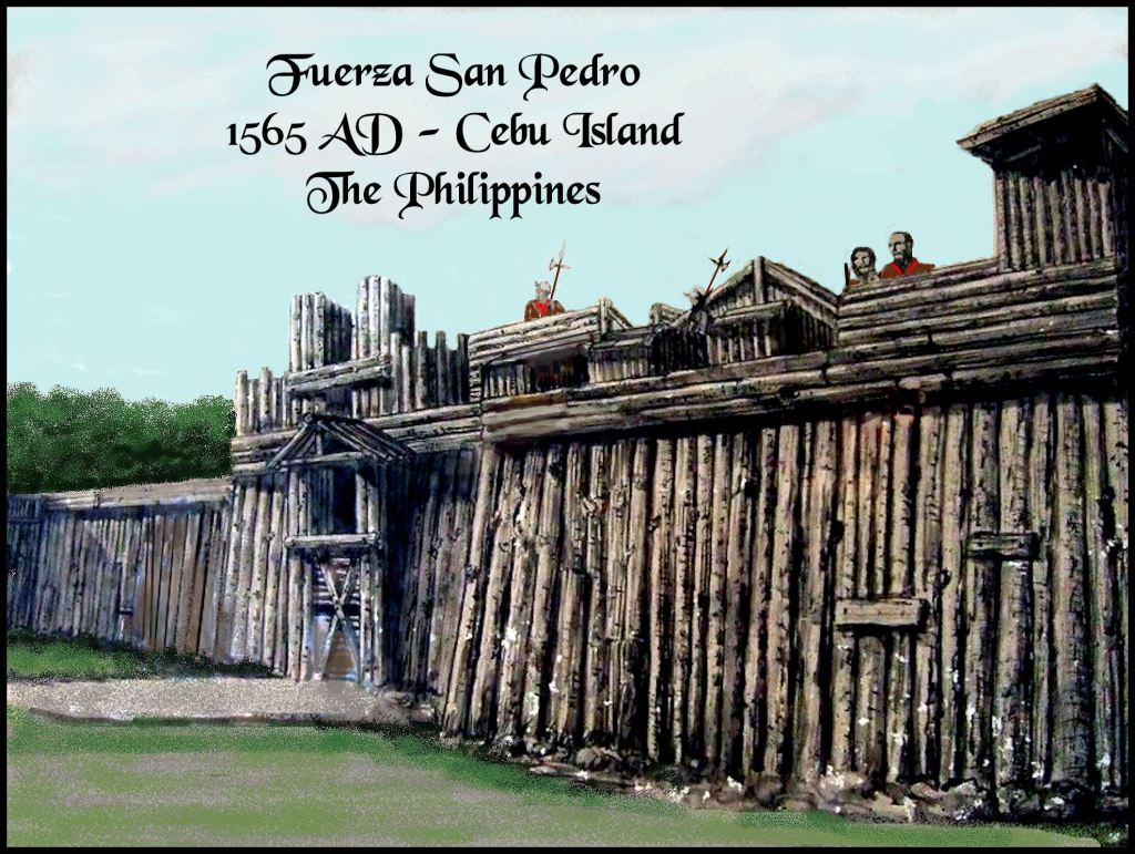
The Southeast U.S. – Philippine Islands Connection
Spanish conquest of the Philippine Islands and Southeastern North America began simultaneously in 1565. For the first time, colonial invasions had the full backing of the Spanish king, Royal Navy and Royal Army. Earlier attempts in North America had been private sector ventures, which all failed to due to inadequate provisions, weather-related catastrophes and hostility by the indigenous inhabitants. Colonists were generously supplied with a year of provisions, plus a full range of livestock AND the backing of Europe’s most powerful army and navy.

In the new capital of a united Spain, Madrid, architects prepared standard plans for full range of forts, plus fortified settlements, docks, chapels, churches, missions and trading posts in the new colonies. Architects in Havana adapted the plans for La Florida, where there were dense forests, but not much building stones easily available until one reached the “Apalachen” Mountains. These were then replicated on lithographs and printed for officers to use in the field. This explains why the early Spanish Colonial architecture in the Southeast and Philippines are profoundly similar.
Initially, all Spanish fortifications in the Southeastern United States and the Philippine Islands were constructed out of earth and logs. Spanish military architects switched to stone in both regions in the 1600s, when logs proved to be inadequate defense against the more powerful naval cannons of that era. However, the only Spanish-built stone fortifications, east of the Mississippi are within the present-day State of Florida.

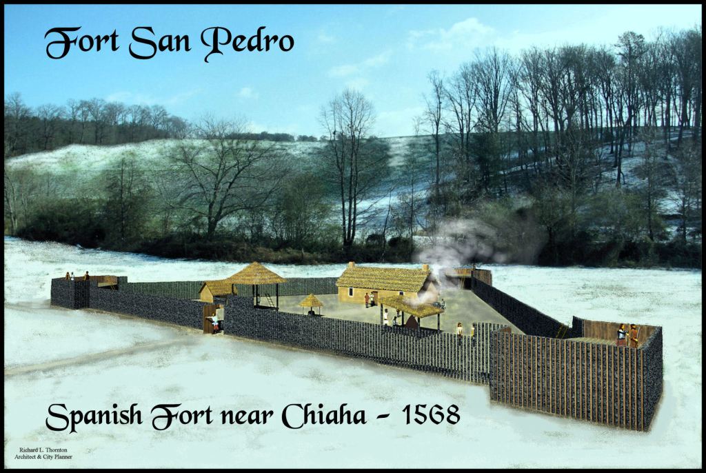
1593 – Spanish architect’s drawing of a proposed fort – Archives of the West Indies – This drawing portrays a large casa fuerte (blockhouse) surrounded by a wall. Such a facility was Pardo’s first construction project in La Florida . . . except his project was built entirely of wood, earth and crude lime-clay stucco.
Types of Spanish fortifications in 16th century North America
Fuerte Costero (Coastal Fort)

In the autumn of 1566, Captain Juan Pardo supervised construction of a casa fuerte (blockhouse), surrounded by a palisaded rampart on the northern edge of Santa Elena (Parris Island, SC). Its landward facing bastions mountain anti-infantry cannons, while those facing the estuary were sized to sink ships. The facility was to serve as headquarters for the Spanish Army in La Florida.
Fuerza Temporal
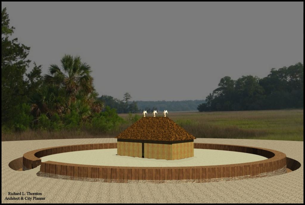
When Pardo and his men were staying for several days or weeks in locations, where they felt vulnerable to attack, they built what we would call today, a “field fortification. They would sequester the largest house or building in the village . . . generally the chief’s home . . . then weave a circular frame around it with saplings and vines. The soldiers would then dig a ditch outside the frame and fill it with the excavated earth.
Since in that era soldiers had to remain standing to load and cock either a musket or a crossbow, this type of fortification would have been very little protection from European soldiers, but would have been more effective against the hand-to-hand combat, typical of battles with Native Americans.
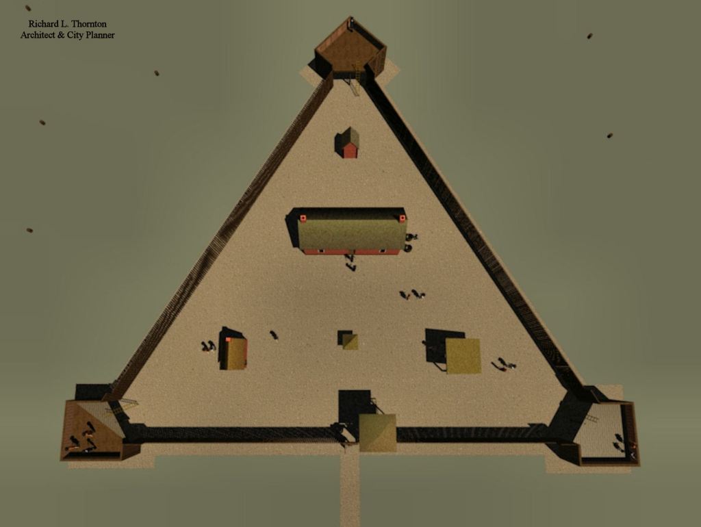
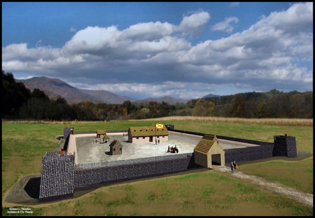
Fuerza Triangular
At lease three of Pardo’s forts were this style. They were intended to hold 15 to 25 infantrymen at locations not subject to assault from large European armies. It was created by digging a deep ditch in a triangular shape. The interior walls of the ditch, then called a fosse, were lined with vertical logs, which were then extended upward to form a protective palisade. Immediately inside the palisade was an earthen firing ramp. It was gently sloped so that musketeers and crossbowmen could load and cock their weapons on the parade ground level of the fort then step up the ramp to fire at the enemy.
The corners of the triangle contained one to three raised bastions. These forts were in remote locations and thus, were not likely to have cannons on the bastion . . . unless it was small cannon tube that could be hauled on the back of a pack horse, mule or donkey.
Of course, we are not certain what structures were erected within the infantry fuerzas, built by Pardo’s men. Forts built in and near Santa Elena contained a guard tower next to the entrance gate, a casa fuerte (thick-walled barracks) for the garrison, a cabin for the commanding officer, an outdoor kitchen, a latrine, a woodshed and an open shed for meetings, dining or relaxing in good weather.
Structures erected by the soldiers either had vertical log walls or were crude, pole-framed with wattle and daub walls. However, in several Native towns, De la Bandera specifically stated that local Natives had agreed to build the barracks for their unwanted Spanish guests. These would have been post-ditch construction with wattle-and-daub walls and thatched roofs. They probably would have been very similar to houses of Native leaders.
A likely location for the Watari fort was on the Catawba River at present-day Old Fort, NC
Fuerza Cuadrangular
De la Bandera said a large 4-sided fort was built near a major town of the Watari People. The Watari were a Uchee tribe that at the time of European contact, were spread across the Central North Carolina Mountains. They were later called the Watagi (Watauga) by the Cherokees. However, they were drifting southward along the Catawba River. By the time, Charleston was founding in 1670, most of the Watari were living in present-day South Carolina. Their portion of the Catawba River was named the Wataree River.
A much larger garrison was left at the Fuerza Watari . . numbering about 40 men. The Spaniards participated in a joint raid against the arch-enemies of the Watari, the Chiska. Thus, the placement of a garrison amongst the Watari seems initially to have been accepted by them.
The Chiska lived in northeastern Tennessee along the Holston River. The Chiska of Tennessee were a South American tribe, who dressed identically to the Chiska of Peru. Chiska means “Bird” in the Panoan languages of Peru and the Southeastern United States. The Cherokee word for its Bird Clan today is Chisqua . . . but that is not the Cherokee word for “bird.”
Coming home to twin disasters
Pardo and his remaining soldiers returned to Santa Elena in March 1569. Soon thereafter, he received word from the two survivors that all five of the forts he had establish in the interior of La Florida had been massacred by neighboring Indian warriors. Approximately 124 Spanish soldiers had been killed Spain had lost more soldiers in those massacres than Cortez did, when he conquered Tenochtitlan. Things were to get much, much worse.
Dominique de Gourgues was a French nobleman and officer in the Catholic army of the Duke of Guise. The most accurate and detailed information about his life comes from a book, written by English historian Richard Hakluyt in 1584. The Wikipedia article about his activities on Atlantic Coast contains many omissions and considerable false history, deleted or inserted over the years by anonymous persons. Due to the occult nature of Wikipedia these days, it is impossible to remove the false history or reinsert redacted paragraphs. For example, the article list several Georgia tribes as being in Florida and “clans of the Timucua.” In fact, though, the tribes on the Georgia coast were arch-enemies of the Timucua in Florida.
De Gourgues considered the founders of Fort Caroline to be moderates and loyal Frenchmen. Fort Caroline had flown the French Royal flag, not the flag of one of the Protestant armies. De Gourgues was outraged that the King of France had done nothing about the massacre of about 1200 French Protestants on the South Atlantic coast by the soldiers of Pedro Menendez.
De Gourgues personally financed an expedition to the South Atlantic Coast. In November 1568,He established a covert base on the Medway River near present-day Midway, GA. He and his officers met with Native America leaders on Ossabaw Island, southeast of present-day Savannah. He and his small army of about 200 men then disappeared into the interior of the Southeast for three months.
They reappeared on the Georgia Coast in late March, then sent out the word to attack the Spanish forts. On Sunday April 18, 1569, the combined French-Indigenous army attacked the two coastal forts at the mouth of the Rio Secco (Altamaha). The 30 Spanish soldiers, not killed in combat, were summarily executed.
On the morning of Monday, April 19th, 1569 the French-Indigenous army attacked Fort San Mateo. All Spanish soldiers, not killed in combat, were hung, one at a time, from nearby trees. Approximately, 380 or more Spanish soldiers died. Their corpses were left to rot in the Georgia sun.
It was the worst defeat ever experienced by the Royal Spanish Army until the Battle of the Flint River in 1703, when a Creek Indian army, armed with muskets, killed approximately 600 out of 800 hundred Spanish soldiers, invading the Creek homeland of present-day Georgia. Only 32 Spaniards returned to St. Augustine, who were not seriously wounded. Fort San Mateo was never rebuilt. It catastrophic capture was never mentioned again in the royal archives.

The destruction of Fort San Mateo – April 19, 1569

Thank you, Richard! Once again you have painted a vivid picture of our true Southeastern history!
LikeLiked by 1 person
More are coming . . . this year, with realistic people and animals!
LikeLiked by 1 person