
As our series continues, advanced virtual reality, laser scanning and LIDAR technology will be taking you back to the 17th century, when the High King of the Apalachete established a place of refuge for people of all races at the old Tabascan Maya town of Cho’i-te. It is now Helen, Georgia. The Apalachete required all single adults, who settled there, to marry Native American spouses. Within a generation or two, many of their offspring considered themselves to be full-blooded Native Americans.
In 1646, the Governor of La Florida, Benito Ruíz de Salazar Vallecilla, constructed a pack mule trail from St. Augustine to the headwaters of the Chattahoochee River. At the termination of the trail, a large fortified trading post and small mission were constructed. English merchant, Edward Bland, formally of Spain and the Canary Islands, now of Jamestown, Virginia, was a major investor in the project. Immediately, after he arrived in Jamestown, he met with the governor, then headed south to visit his investment. It is highly probable that Virginia’s Royal Governor, Sir William Berkeley, was also an investor. Governor Salazar soon established a mule-breeding farm near the fort.
Architecture of the North American Frontier Series
Special thanks goes to the owners of Studio Base 2 in Paris, France, which produces Artlantis software. Over the past year and a half, they have graciously and repeatedly helped me adapt their software to the accurate portrayal of the architecture, people and livestock of the past.
Background
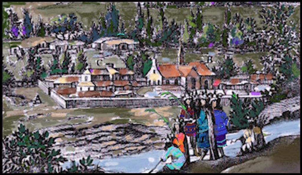
Fanciful 1658 engraving of the Spanish fort, trading post and mission at the headwaters of the Chattahoochee River by Dutch engraver, Arnout Leers. It was based on sketches by British explorer Richard Brigstock, made on site in 1653. Several engravings, based on Brigstock’s sketches were included in the ten chapters about present-day Georgia in the book, l’Histoire Naturelle et Morale des isles Antilles de l’Amérique
There are several, published eye witness accounts of the Spanish fortified compound in northeast Georgia or encounters with Spanish-speaking merchants based at this trading post by English and French explorers. The official state history textbooks of Florida and Virginia discuss this trading post. Georgia’s does not. In fact, Georgia’s textbook does not even mention Spanish mining and trading activities in the mountains. This is inexplicable because the official map of the Georgia Gold Belt, published by Congress in 1832, does mention them and displays a 17th century Spanish gold refining retort on the map! During the Georgia Gold Rush two Spanish mining villages were unearthed in the Nacoochee Valley . . . measured and heavily publicized in newspapers.
Virginia’s textbook states that Edward Bland traveled to the southern tip of the Appalachian Mountains to inspect his commercial investments. The North Carolina official history textbook states that while living in Europe, Bland heard about the powerful Cherokee Nation! As soon as he arrived in Jamestown, he traveled southward to the North Carolina Mountains to meet “great Cherokee chiefs.”
Ridiculous! Both French and Dutch maps show the Cherokees living in Canada until 1650. There are many mentions of the Cherokees being in Nouvelle France by Samuel Champlain. He claimed to given the tribe their name. The earliest map to show the Cherokees living in North Carolina was drawn in 1715.
Prior to 1706, French maps, prepared by professional civil engineers, who had traversed the rivers of Tennessee, western North Carolina and northwest Georgia, showed most of the villages occupied by Creek, Chickasaw, Shawnee and Uchee tribes. Cherokee Principal Chief Charles Hicks wrote in his 1826 manuscript, The History of the Cherokee People, that Cherokees did not reach the southern mountains until about the time that Charleston was founded (1670). They did not enter western North Carolina until after the Great Smallpox Epidemic of 1696. Very few entered Georgia until after the American Revolution.

This map clearly shows the road from St. Augustine to the Nacoochee Valley. It also shows the location of the mission and some of the names of the major Native American towns in the Nacoochee Valley. The double red and blue line is the boundary of lands claimed by Spain and France. The Native towns, closest to the fort were named Apeke and Apala. They moved southwestward into Alabama and west Georgia in the 1700s.

Knowing Itza Maya grammar, I am fairly certain that the town listed on the map as Asokihi was actually Isokihi . . . which means that this was the capital of the Soque Province. Using lidar in 2019, I was able to find the earthen pyramids of Isokihi in Batesville, GA. The largest pyramid covers seven acres and originally had a stone veneer like the pyramids in Mexico. Both the Native American and Anglo-American occupied village of Sautee was located on the Soque River until around 1924.

Using USGS LIDAR, I was able to pinpoint the location of the Spanish compound. It made perfect sense. The fort was built on the site of an old Itza town, which was on a natural terrace overlooking the Chattahoochee River and Smith Creek. It was adjacent to the intersection of three important regional trade paths. Upstream from this confluence the Chattahoochee is merely a modest creek.

I did a great deal of research prior to creating the digital 3D figures. As you tour the Nacoochee Valley through these articles, you will see extremely accurate clothing on both the European colonists and the Indigenous people. For example, wide brimmed , felt hats were much he rage in Europe during the 1600s. Spanish colonists quickly switched to straw sombreros, which could be inexpensively produced by Native basket makers, plus were much cooler in the summer.
This virtual reality scene portrays English Royalist, Richard Brigstock, introducing himself to the captain of the Spanish fort and trading post. During his year in what is now Georgia, Brigstock developed friendships with many of the Spanish colonists. Most of them were either Jewish or from the mountainous northwestern corner of Spain, which was the only part of Spain to import Protestant religious concepts. (Navarre, Galicia and Asturias) The priest in the mission had a Native American mistress. It seems that all of the people there, were trying to put distance between themselves and the Spanish Inquisition.
The Apalachete elite had been converted to Protestant Christianity by survivors of Fort Caroline in the 1560s. There was also an Anglican Church community, which settled in the Kingdom of Apalache to avoid the constant wars and plagues occurring in Virginia. All seemed to get along just fine. Because all of their children were at least half Native American, the various European ethnicities over time came to view themselves first as Apalachete (Creek, Chickasaw and Soque Indians).
Beginning with my next article, readers will accompany Richard Brigstock as he walks around the Nacoochee Valley to visit with its Native American and European residents . . . then later travels to visit the Spanish gem miners living in the vicinity of present-day Franklin, North Carolina. You will thoroughly enjoy meeting the people, who late 20th century academicians erased.

I agree with you Richard. There’s so much hidden history in the Appalichian Mountains. Whenever you’re ready for a field trip come on up to my neck of the woods along the banks of the Nolichucky. There’s a’plenty history here. It’s taken me 72 years to correlate what I grew up with here, to reading your insightful, well researched articles for many years, along with my family geanology to become this enlightened. I have my theories that I have tested out and I’m constantly making new discoveries. Sad part is no one gets it. They can’t see the Big History Picture Here. All I can say is it’s exciting for me.
LikeLiked by 1 person