by Richard Thornton, Architect & City Planner
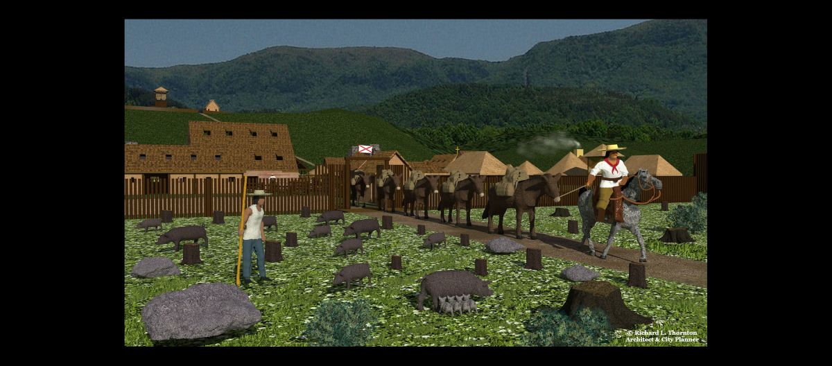
Image above: This computer drawing by the architect shows a mule train leaving the Spanish trading post on the Unicoi Trail. It will exchange European manufactured goods for furs, deer skins and gems in the Tennessee River Valley.
The 17th century Spanish colonists, traders and friars in Georgia brought their famous Black Iberian pigs them. Many became feral. The wild population grew faster than either Indigenous Peoples or Europeans could hunt them, then spread to much of North America. There are now about 600,000 wild Iberian pig descendants in Georgia . . . 6 million in the USA!
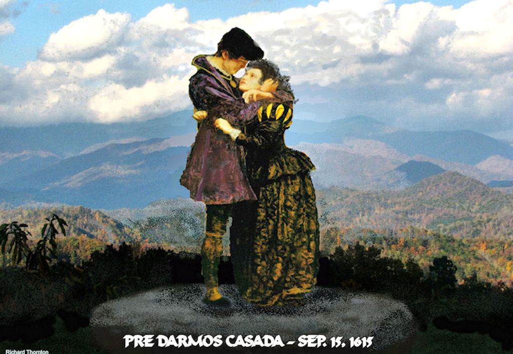
In April 2010, I discovered this Ladino Spanish rock engraving on top of a mountain in western North Carolina. It reads, “Prayer, we will give, married September 15, 1615.” Something that my Creek Indian grandmother had told me, suddenly made sense . . . “There were White men living in the Georgia Mountains a hundred years before there was such a thing as a Cherokee Indian.”
I soon realized that the Southeastern United States had a forgotten or even intentionally concealed history, which was not being taught to its students. At that point in life, I decided to use my skills as an architect, urban planner and sleuth to uncover that history.

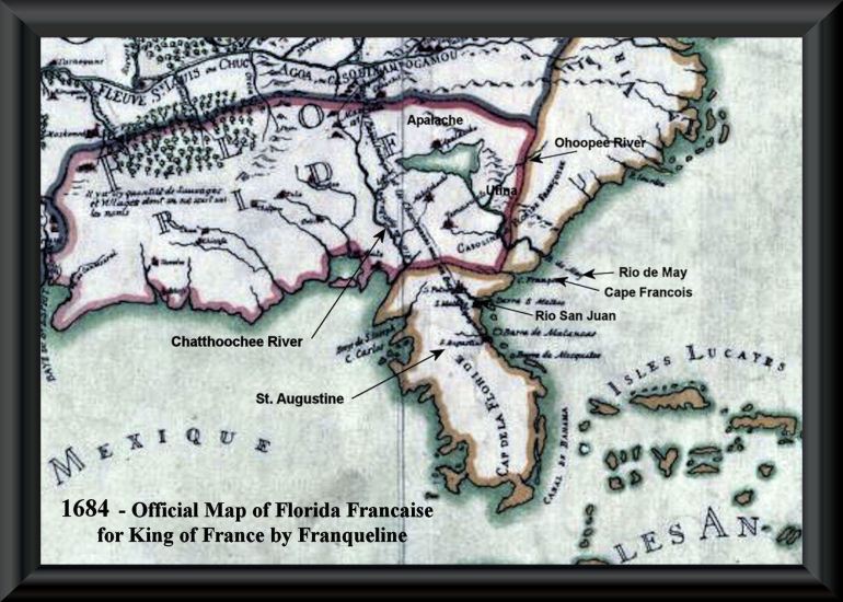
The recent discovery of a fortified trading post site, north of Helen, GA, explains the presence of European trade goods being found by the first French explorers as far west as the Mississippi River, plus 17th century maps and eyewitness accounts describing Spanish-speaking soldiers and traders in the Southern Appalachian Mountains. In 1684, 17th century French mapmaker, Jean Baptiste Franquelin even drew a road from St. Augustine to present-day Helen, GA that then was extended to Hiwassee and Bussell Islands, Tennessee.
It also explains why most families in Northern Georgia, who claim Cherokee ancestry, find that they have little of no Native American DNA, but significant levels of Sephardic, Asturian, Galician, Majorcan, Moorish or Portuguese ancestry. Those who do have Native American DNA find that it is from southern Mexico like the Creeks. Several of the Creek towns in the Georgia Mountains continued to speak Spanish as their primary language after moving to Florida and becoming part of the Seminole Alliance. There is an Ellijay, GA and an Ellijay in South Florida!
Very frankly, a clique of late 20th century, Southeastern university professors did not do their homework! They produced a series of books and professional papers, which claimed that practically nothing is known about the interior of the Southeast during the 1600s. They tried to make us believe that Cherokee occupied all of the region after 1585! The absolute truth is that French and Dutch colonial archives place the Cherokees in Quebec until 1650 and not entering extreme northeastern Tennessee until the late 1680s!
The Kusate-Creek capital of Kaushe (Coosa) in Northwest Georgia. It was visited by the Hernando de Soto Expedition in the summer of 1540.
The secret history of the Southeastern United States
The migration legends of the tribes that joined to become the Creek Indian Confederacy describe journeys from southern Mexico to Georgia in ancient times. They were descendants of the peoples, who founded the Olmec Civilization, but fled their homeland when oppressed by cruel, child-sacrificing invaders from Teotihuacan and in later centuries, the Chichimecas.
Even today, there are many Western Maya words in the Creek Indian languages. Georgia contains several rivers with Maya names. All of my Native American DNA is from southern Mexico and eastern Peru. That is typical of Creek Indians.
The first attempt by Spain to establish a colony, Pueblo San Miguel de Gualdape, was founded in 1526 on the coast of the State of Georgia. During 1526, the Hernando de Soto Expedition crisscrossed the future state of Georgia. Its chroniclers stated that while in present-day Georgia, they never lost sight of houses or cultivated land.
In late 1565, the Spanish began construction of Fort San Mateo. It is a little known fact that the first location of the town of San Augustine was on Saint Andrews Sound on the coast of Georgia. In March 1566, the colony moved to its present location in the state of Florida. The Native American soldiers of Georgia were too numerous and too sophisticated for the Spanish soldiers to handle.
From 1570 until 1684, the Jesuits and Franciscans operated missions . . . mainly on the Georgia Coast. A few missions were within the interior. At their peak, there were twice as many Spanish missions and mission Indians in the future state of Georgia as there ever were in Florida.
There are several published accounts of English-speaking colonists interacting with earlier Spanish-speaking colonists in the South Appalachian Mountains during the 17th and 18th centuries. A European community in the region, called Melilot, was founded in 1566 by French Protestant survivors of Fort Caroline. Soon, Spanish Sephardic Jews, escaped African slaves and English bond servants, English Protestants, Dutch Jewish or Protestant traders and ultimately, gold miners from Asturias, Galicia, Navarre and Portugal were also allowed to settle in the region.
In 1646, La Florida’s governor, Benito Ruíz de Salazar Vallecilla, constructed a road for pack mules from Saint Augustine to the headwaters of the Chattahoochee River. Here, he and his English invester, Edward Bland, built a fortified trading post, fort, mission and mule-breeding farm. The road was soon extended over the Native American Unicoi Trail to the Tennessee River, in order to trade with Creek Indian tribes, living there.
The official Florida and Virginia State History textbooks mention this project. Georgia’ s official history textbook does not mention it. In fact, it does not mention the 17th century colonists in the future state at all. In contrast, North Carolina’s and South Carolina’s official history textbooks DO mention that there were Spanish-speaking gold miners in northern Georgia.
The most extensive account of this Spanish colony was by English explorer, Richard Brigstock, in 1653. He was a cousin of Edward Bland. Brigstock was considering the relocation of his family from the island of Barbados to the Kingdom of Apalache, which then including almost all of the southern Appalachian Mountains.
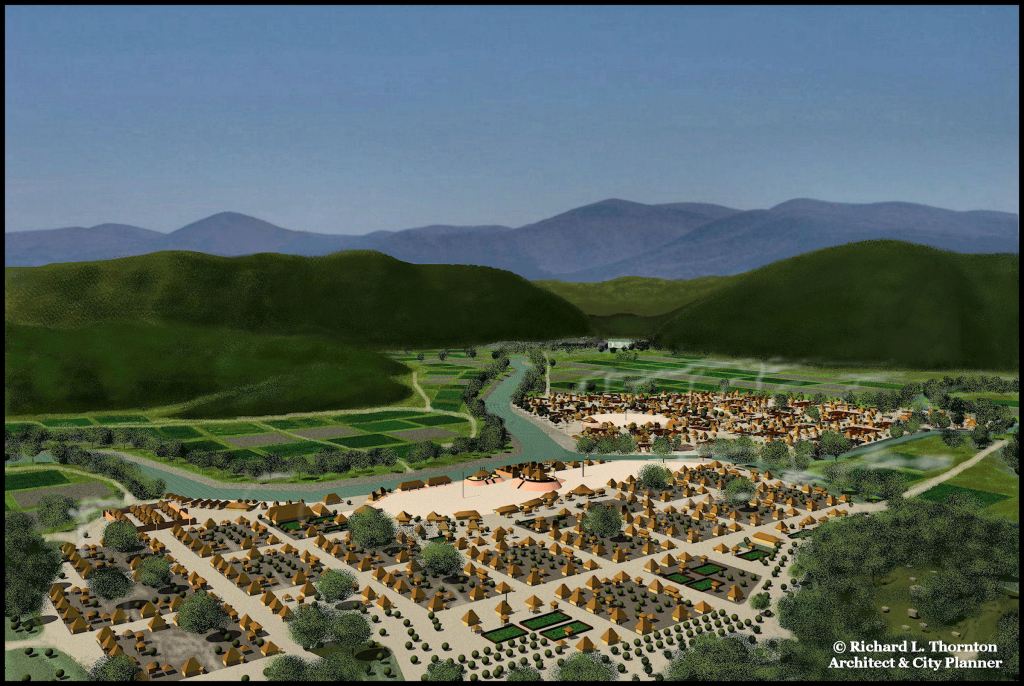
Brigstock stayed in the Capital of Apalache in the Nacoochee Valley most of that year. He was housed in the town Cho’i-te, which was reserved for immigrants of all three races. It is now Helen, Georgia. The Spanish fort, trading post, mission and mule-breading farm were located about 1.6 km (1.0 mile) north of Cho’i-te.
Brigstock spent much of his leisure time, chatting with the priest at the mission or with employees of the trading post. Brigstock also spent a few weeks with Spanish gem miners in what is now Franklin, North Carolina.
The leaders of Apalache required all single Europeans and Africans to marry Native American spouses. Thus, the second generation of colonists were tall mestizos. The Creek Indians averaged about .3 m (1 ft.) taller than Europeans.

17th century Iberian gold refining retort – Nacoochee Valley
Georgia Gold Rush (1826-1848)
As soon as the gold miners began tearing into the fertile soil of the mountains, they began finding European artifacts, most originating from Spain. In the next few years, the miners uncovered two Spanish mining villages in the Nacoochee Valley. Both villages were heavily publicized in Georgia newspapers.
A wide range of tools, weapons and domestic artifacts were excavated by the miners. They included Spanish cigar molds! Evidently, some of the Iberian colonists included tobacco farmers and skilled cigar makers.
In 1832, the United States Congress authorized printing of a geological report and accompanying map on the Georgia Gold Mining Region. Both the report and the map acknowledged an extensive 17th century presence of Iberian miners in the Nacoochee Valley. The map even displayed a Spanish gold refining retort.
In 1849, explorer and Smithsonian Institute naturalist, Charles Lanman, visited the Nacoochee Valley. He visited the well-preserved ramparts of an ancient fort about two miles north of the Nacoochee Mound. It definitely predated any Revolutionary or Indian Removal fort in North Georgia. This was the exact same location in 2023 that I found the footprints of a fort and several buildings with LIDAR and infrared analysis.
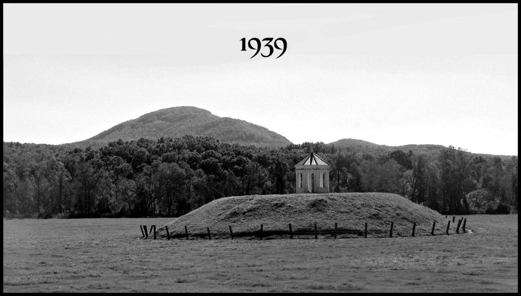
1939 – Archaeologist Robert Wauchope in Georgia
Robert Wauchope grew up in Columbia, South Carolina, but received a Ph.D. in Anthropology from Harvard University. Shortly after graduation, he was hired by the U. S. Works Progress Administration to carry out an archaeological survey of northern Georgia. His book, An Archaeological Survey of Northern Georgia contains the first and only description of hundreds of archaeological sites that have never been professionally studied since then.
After World War II, Wauchope was a professor at Tulane University for the rest of his career, where he became an internationally-recognized expert on the Maya Civilization. I carried with me his book on Maya houses while traveling through much of Mexico on an academic fellowship. Ironically, Wauchope never realized that “Chattahoochee” is an Itza Maya word!
You see . . . Wauchope was supposed to visit and study approximately 40 counties, but ended up spending most of his time in the Upper Chattahoochee River Valley from Atlanta to Helen, Georgia. In particular, he discovered that the upper section of this river (the Nacoochee Valley) was one continuous archaeological zone that had been continuously occupied from the Ice Age to the present. Encyclopedia Britanica now describes the Nacoochee Valley as the largest and most densely occupied archaeological zone, north of Mexico!
When Wauchope’s laborers were digging down to levels of Native American occupation, they always encountered numerous 16th and 17th century tools, weapons, musical instruments and domestic artifacts. Wauchope also viewed extensive collections of Colonial Period European artifacts in the homes of local farmers. He stated that the combination of his and the local families’ European Colonial Period artifacts could easily have filled a tractor trailer.
Wauchope did not find any Cherokee artifacts or villages in the Upper Chattahoochee River Basin. Up until the level of the mid-16th century all artifacts were similar to those of Proto-Creek Peoples at Ocmulgee National Historical Park. Afterward, there was an increasing quantity and variety of European artifacts in the archaeological record, mixed with Historic Creek artifacts.
There was a archaeologically sterile layer of alluvial sand, dating to about 1700 AD. The sand deposit varied from five to fifteen feet (1.5-4.8 m) thick. Above the sand, almost all the artifacts were of European or British Colonial manufacture. There were a few fragments of Creek Indian style pottery.

European gold mines
In the 1980s, a team of geologists analyzed the mine timbers of several gold and silver mines in northern Georgia and western North Carolina. They used tree rings and radiocarbon analysis to determine the ages of the mining timbers.
All of the timbers were squared off with European steel axes and saws. The trees for the mining timbers were cut between 1585 and 1630. The oldest mines were in the Georgia Mountains.

The situation today

Because of Georgia’s former anti-Native American laws, my mother was the first person in her family, who was allowed to graduate from a public high school. She was her class valedictorian at age 16 and attended the University of Georgia on a full scholarship, graduating Magna Cum Laude. She went on to eventually obtain two post-graduate degrees and a teaching position at the University of West Georgia. After named State Teacher of the Year in the mid-1980s, she was placed on the State History Curriculum Committee.
My mother fought in vain to create a more accurate state history curriculum textbook, which still leaves out almost all of the history of North Georgia prior to the 1800s. She also sought to replace the many fictional Native American historical markers in North Georgia . . . to no avail.
There was and still is no mention of the Uchee, who occupied a region of the state much larger than the original Cherokee Tribe . . . for thousands of years. The Cherokees were in the northwest corner of Georgia from about 1784 until 1838. There is also no mention of the Chickasaw, who occupied large swaths of the state from around 600 AD onward. Also, there is still no mention of the French and Spanish-speaking colonists, who apparently began settling in northern Georgia in the late 1500s.
I am facing the same stone wall that my mother faced. People, who know absolutely nothing about the early history of the Southeast, ultimately hold all the power in determining, what students are taught and what tourists see on signs or brochures. No archaeologist has examined a 17th century colonial site in northern Georgia, since Robert Wauchope left the state in 1940.

What “Georgia Mountain Music” would have sounded like in the 1600s!

It’s interesting that you mentioned a layer of alluvial sand. After almost 30 years of living on my property, last week I began to notice sand alongside my driveway and in my front yard and wondered where in the world it came from.
LikeLiked by 1 person
It was one massive flood. Apparently, it wiped out much of he population of the valley around 1700. We know that Chimney Mountain erupted bigtime that year. Perhaps it instantly melted the snow.
LikeLiked by 1 person
Though it wasn’t apparently in his interest or purview perhaps, I’m wondering if Wauchope mentioned Upstate South Carolina specifically Chauga in his “findings”?
LikeLike
Wauchope spent a brief period on the Georgia side of Tugaloo. I believe he briefly mentioned another town site on the South Carolina side. At that time neither Tugaloo Island nor Chauga had been excavated.
LikeLike