Part One of a series on floods
by Richard L. Thornton, Architect & City Planner
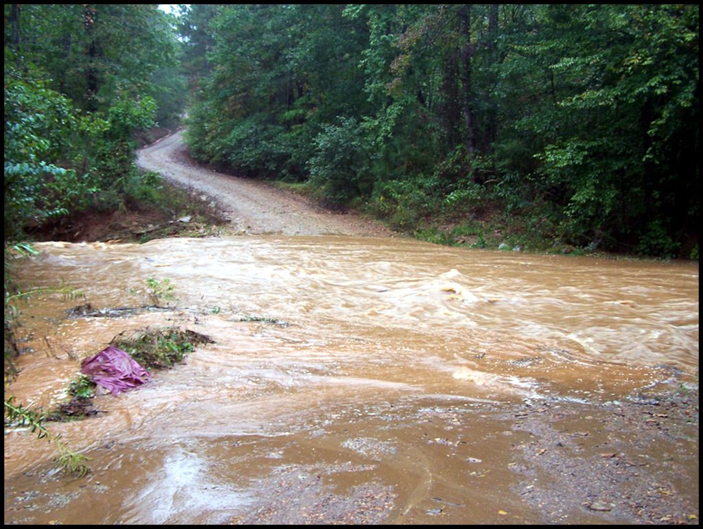
The following article was published as part of a series in my National Architecture column of the Examiner during September 2010, after my campsite in the Nantahala Mountains of North Carolina, was washed away by a flash flood, caused by the remnant of a hurricane. Fortunately, I had a “then” high tech, portable, solar-and-handcrank-powered emergency radio, which turned on and announced a National Weather Service flood warning. I quickly dragged my tent and food containers to higher ground . . . only minutes before the location was covered with about three feet of fast-moving water. Some sentences in the article have been updated.
A few days after I returned to the United States in mid-December 1972 from working in Sweden, plus other assignments that could not disclosed for 20 years, I was hired by RBA, Inc. . . . then one of the nation’s top architecture-engineering-planning firms. It was located in the new planned city of Columbia, MD, which is about halfway between Washington, DC and Baltimore, MD. It was composed of the team that had planned Columbia! The job offer was no fluke. My boss was a Captain in U.S. Army Intelligence.
My first assignment was being on a multi-disciplinary team, which had been hired by the State of Louisiana to study the impact of major hurricanes on the region. Based on the effects of recent hurricanes, state officials were concerned that the U. S. Army Corps of Engineers had not adequately planned flood controls in the state.
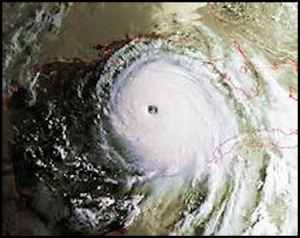
Indeed! The team determined that a major hurricane, approaching the New Orleans Metro Area from the southwest, would cause catastrophic flooding and loss of life in New Orleans. The system of levees, dams, canals and locks, constructed by the Corps of Engineers since 1804, would actually worsen the severity of flooding. The lower third of Louisiana would be temporarily under water.
I was the only member of the professional staff, who had not graduated from an Ivy League University or MIT. Georgia Tech did not have the international prestige that it enjoys today. Using that fact, the administrators of the Corps of Engineers labeled the study “a bunch of poppycock by Ivy League eggheads.” Economic development leaders in New Orleans decried that such “fake science” would scare away potential corporate headquarters and commercial growth. The report was essentially tossed into a trash can and intentionally forgotten.
Thirty-two years later, I was asked by the Muscogee-Creek Nation to enter a Louisiana, ravaged by Hurricane Katrina, to lend immediate assistance to Native American reservations, south of New Orleans, and determine what other aid the MCN could provide. The Louisiana National Guard would not let me travel to the reservations, so instead, for two macabre days, my two herd dogs and I helped find human cadavers.
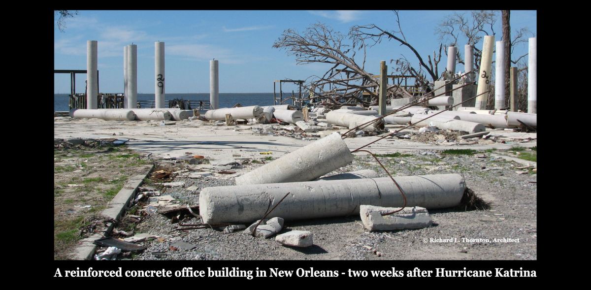
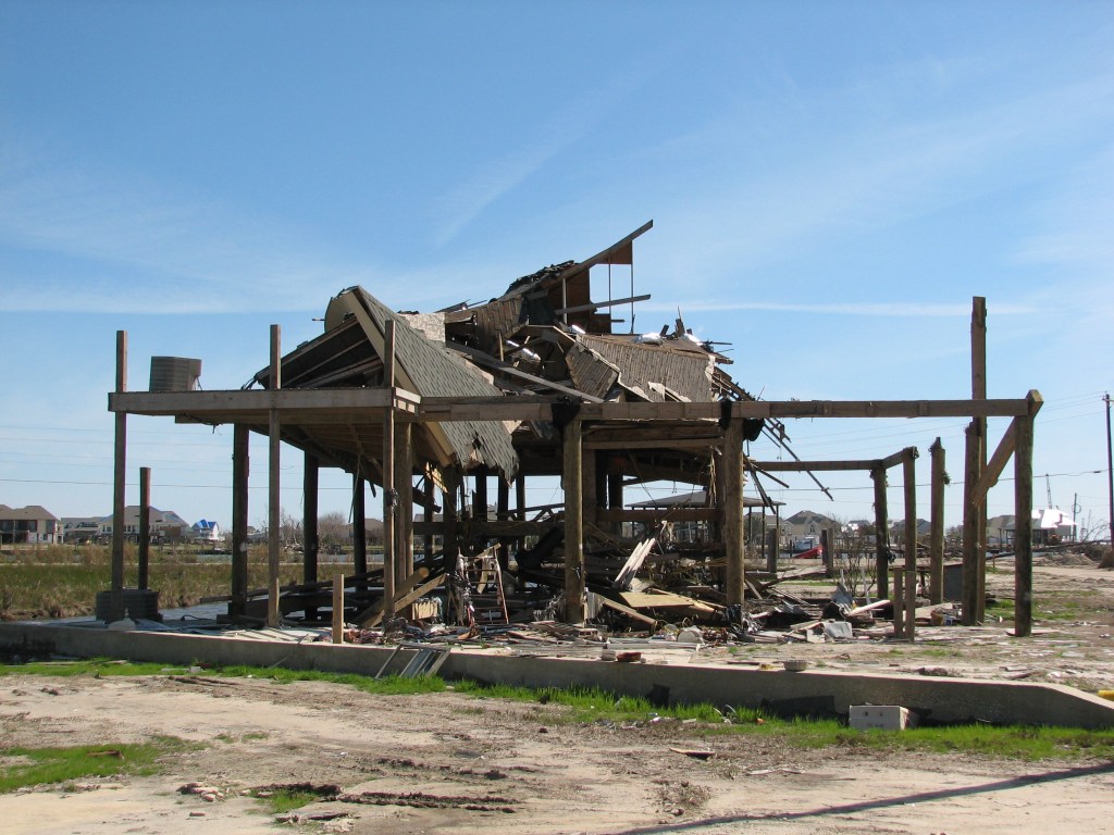
A few weeks later, the American Institute of Architects asked me to help plan the restoration of New Orleans then asked me to study on site, the ruins of buildings, constructed to the new Hurricane Code, which nevertheless, were turned by Hurricane Katrina into rubble. Life is stranger than fiction.
Floods destroy property in every state and province
During the past 100 years, flooding has the number one cause of property damage in North America each year, with the possible exception of 2005 when a series of hurricanes, including Katrina struck the Gulf Coast states. Even that exception is subject to debate since much of the property damage done by hurricanes is from storm surges, which flood the landscape. Also, a disproportionate number of the deaths from Hurricane Katrina were caused by the flooding of central New Orleans. (See the Examiner series, New Orleans 2005: the Mælstrøm.)
The actual economic impact of flood damage is difficult to gauge, since it is so widespread and variable in character. Private insurance companies no longer insure flood damage in the United States. Structures Flood Hazard Zones designated by the Federal Emergency Management Agency (FEMA) are eligible for special flood insurance. Those buildings outside these zones are not. If a property is not insured for flood damage, then often the costs of the damage never are available to monitoring agencies. The catastrophic problem caused by refusal of insurance companies to issue flood insurance will be discussed below.
The costs of flood damage are estimated to average about $800 million to $1 billion annually in the United States – maybe more [2010 US dollars.] Flood damage annually cost Canadian citizens approximately $200-$250 [CAN] million. This year the total may be greater because of a $65 [CAN] million flood in the Province of Alberta in June of 2010. Annual death tolls from flood have varied considerably from year to year. Total deaths in the United States have varied from 23 to 3,000 through the years.
In 2009 the cost of flood damage in the United States possibly was as high as $1 ½ billion. Catastrophic floods in the northern Great Plains in the spring followed by the worst rain storm on record in the Southeast during September 2009. It caused the total damage costs to soar.
Entire subdivisions in some parts of Metropolitan Atlanta were inundated by an 18”- 24” rain storm, which was the remnant of a tropical storm. Most of these houses were not in designated flood hazard zones, so the houses had no flood insurance. Loss of life due to floods was somewhat higher than average in 2009, but not proportionate to the escalated damages.
Flood Hazard Insurance Program
Ever since the first North American insurance company was formed in Charleston, SC in 1732, flood damage had been a serious threat to the solvency of those companies. Massive floods would create claims from property owners that overwhelmed the resources of smaller companies. During the 1960s the insurance industry persuaded the United States government to become involved with the insurance of properties in flood prone areas, then ceased to insure for flood damage in almost all regions of the nation.
The program went into effect in 1968. Maps were drawn by United States Army Corps of Engineers, which described all of the regions in the entire United States that were prone to certain types (but not all types) of flooding. Building owners in those “Flood Hazard Zones” could obtain insurance for their property, if they complied with regulations, which have become increasingly strict through the years.
New construction is prohibited in some flood hazard zones by the Corps of Engineers. The State of Georgia is one of the few states that prohibit commercial construction in flood zones. In other areas, new buildings must comply with special structural requirements in addition to the International Building Code, plus all occupied spaces must be elevated above an assumed maximum flood level. The administration of Flood Hazard Insurance is now the responsibility of the FEMA.
If a property suffers flood or water damage outside the flood hazard zone, and did not have flood insurance (which is generally unattainable) property owners and tenants must pay for the damages themselves, either directly, or through civil suits against those individuals or organizations that are presumed to be the cause of the flood. A contemporary example of the latter case is the class action suits against the United States Corps of Engineers and FEMA for damage caused by the failure of its levees and canal systems in the New Orleans Area due to Hurricane Katrina.
The property owners and tenants in New Orleans urban areas were refused flood insurance because they were not in a flood hazard zone, even though their buildings were located in terrain formerly characterized as wetlands. An even more common problem was that tenants were not informed of eligibility for flood insurance or were too poor to afford it.
Note: FEMA flood insurance for a single house in 2024 averages about $8000 a year!
The position of the Corps of Engineers is that it built flood control structures as directed and funded by Congress. As a federal government agency, it could only carry out work, which was funded by Congress.
FEMA’s legal position is that it could not legally offer flood insurance to property owners and tenants outside of the official flood hazard zones that were determined by the Corps of Engineers. The position of both agencies toward the inability of poor tenants to pay for flood insurance is that they received inadequate funding from Congress to assist low-income persons.
Federal government agencies ARE limited by funding and laws passed by Congress. However, in 1968 the Federal government allowed private insurance companies to get out of the flood insurance business. Flood insurance became the official responsibility of the Federal government.
Even if Congress has failed during the past four decades to adequate fund flood control projects, or provide insurance for all those citizens, who are potential victims of flood damage, it nevertheless, has assumed responsibility to do so. How the Federal court system responds to this potential billion-dollar liability of the national treasury has yet to be seen.
The problem of flood insurance extends far beyond the issues of the current Hurricane Katrina litigation, however. The original flood insurance program adopted by Congress overlooked many types of flooding by focusing on the designation of official flood hazard zones along large rivers. For example, most insurance companies will not pay for water damage, when tornado or windstorm blows off a roof.
Repeatedly, we are finding areas that contractors for the Corps of Engineers should have designated many locations as flood hazard areas, but didn’t. The big civil engineering firms hired by the Corps of Engineers, are very generous in their donations to politicians, but have often done very sloppy work along smaller rivers and creeks. They almost never do the research required to determine that a real estate parcel was located in previously drained wetlands. Instead, the engineers rely on computer programs, which seem to be derived from the predictable spring floods of major rivers.
2024 Update: Very frankly, in my decades of experience as an Architect-Planner practicing around the Southeast, I have found the FEMA flood hazard maps to be grossly inaccurate near smaller rivers, creeks and wetlands. Also, I learned from interviews by TV reporters of Asheville flood victims, that about six years ago, the North Carolina FEMA office REDUCED the size of the flood hazard zones along the French Broad and Swannanoa Rivers, due to political pressure. Home owners, who had for many years purchased flood insurance were suddenly denied by FEMA.
Since that time, there has been no change in the scope of the laws. Congress still directs the Corps of Engineers to focus on standards for buildings in regions that are prone to spring flooding by streams and rivers – as defined by historic records of past flooding. No allowance is made for the potential damage of flash floods that are unpredictable in nature. This approach continues to leave millions of citizens vulnerable to flash flooding and hurricane flooding.
The position of the Bush Administration was that other types of flood damage were best handled by civil litigation and local governments. There has been no publicly stated change of policy by the Obama, Trump and Biden Administration in this area of concern, so presumably the same policy continues. However, it is the families devastated by these other types of flooding, that can least afford to hire an attorney to sue the responsible party.
In the next segment of this series, we will discuss the type of flood damage that may affect property and human lives.

LikeLike