
Readers will learn “dirty little secrets” from the past, which the news media never told you!
Most of the many, many thousands of artifacts unearthed at Etowah are in private collections!
Even in 2024, only about 7% of the total town area has been excavated by professional archaeologists!
The Peopling of Eastern North America Series
by Richard L. Thornton, Architect and City Planner
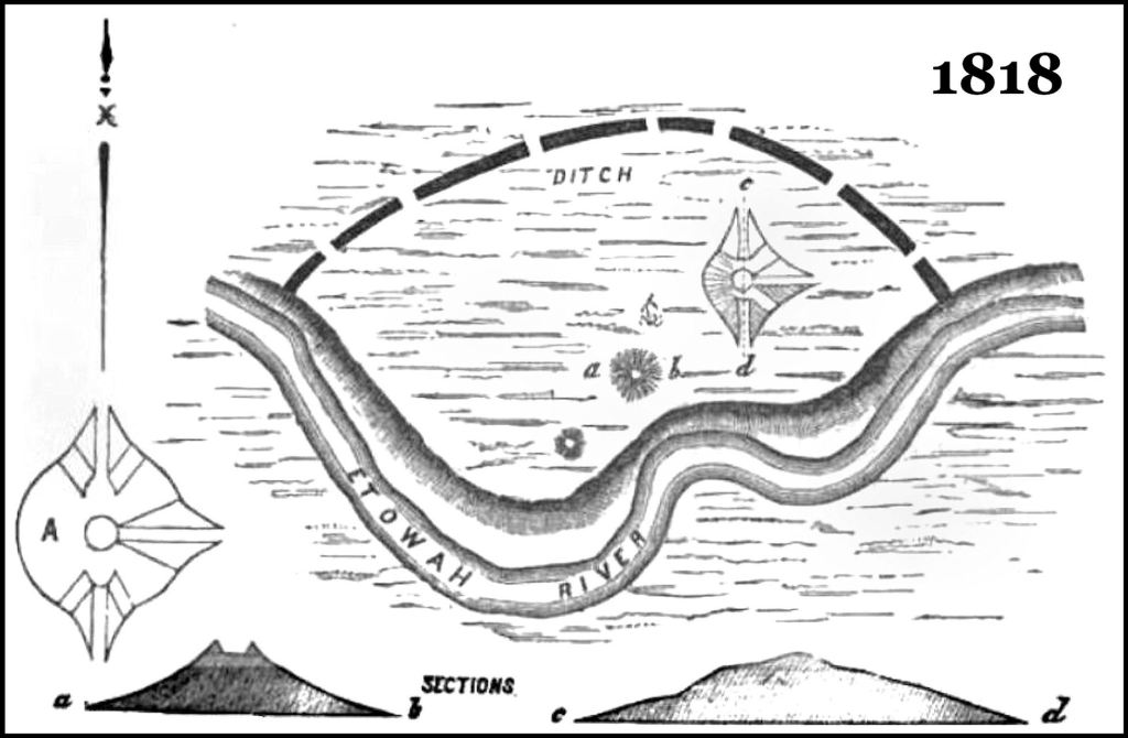
Scaled drawings of Etowah Mounds by Dr. Elias Cornelius of Yale University in 1818, The giant mound at that time had three ramps, but did not have the terrace and massive ramp on the south side, which makes it seem unfinished. Note that even as early as 1818, somebody had been digging at the top, in search of artifacts or “gold”?
Before we discuss the inadequacies of the current exhibits and literature at Etowah Mounds Archaeological Museum in Cartersville, GA in another article, I thought it was important that readers be exposed to a comprehensive chronology of activities at this important archaeological zone during the past three centuries. This is information that they will not see either at the museum or in texts, published by contemporary archaeologists.
I was blessed to have the architect of the Etowah Archaeological Museum, Julian Harris, as a professor almost every quarter of the five years that I studied architecture at Georgia Tech. During this period, his close friends, archaeologists Arthur Kelly and Lewis Larson, plus Atlanta Archaeological Society President, Architect Ike Saporta, also provided “insider information” that I now have, which is missing from the current archaeological curricula in Georgia.
Ironically, the famous National Geographic archaeologists-couple of George and Gene Stuart, were two of my closest friends, when I lived in North Carolina and Virginia. As a teenager, George worked under Kelly and Lawson at their Etowah Mounds dig, one summer. Several years later Gene was a teacher at Cartersville High School. Like me many years later, her home was near Etowah Mounds. Because of her frequent visits to Etowah, she eventually went back to college to become an archaeologist.
In 2006, the Muskogee-Creek Nation contracted with me to intensively study the discoveries made by archaeologists in the Etowah River Valley. During that study, I hiked or canoed the entire 164-mile (264 km) length of the river . . . from its source at the crest of the Blue Ridge Mountains to its confluence with the Oostanaula River in Rome, GA. From December 1998 to June 2000, I had rented a home in Rome that overlooked that confluence.
Etymology
Etowah is the Anglicization of the the Cherokee-nization of the Itza Maya and Itsate Creek word, word, Etula, which means “principal town.” Tula was also the original name of Teotihuacan. The Muskogee-Creek word, derived from Etula, is Etalwa. Most Georgia Creeks spoke Itsate until the late 1700s.
Changes made by Mother Nature
Until around 1200 AD the Etowah River flowed north of the entire town site scene today. About 1200 AD, a catastrophic flood, probably caused by a hurricane, swept across the entire town. A new channel was started roughly, where it flows today, which split the original town in half. Initially, the northern half of its ruins were on an island, but over time the reoccupied northern town site was surrounded by swampland.
- In 1886, another catastrophic flood, caused by a hurricane, cut a massive gouge through what had been the heart of the second town.
Timeline
c. 1700 AD – By examining the ages of the oldest trees growing on the mounds, Elias Cornelius determined that this was the approximate date, when the town was permanent abandoned by a people associated with the Creek Confederacy. The first Cherokees arrived in the area around 1795 AD, but never lived within a mile of the mounds, because they thought the ruins were haunted! The museum tells you that the site was abandoned by the Creeks around 1585 AD. Supposedly the town was then burned and reoccupied by the Cherokees.
1684-1763 – French maps showed the Etowah River Valley from the Allatoona Mountains northwestward to present day Rome, GA being primarily occupied by Apalachicola Creeks. There were also some large villages, occupied by tribes, who lived on the Georgia Coast, when it was first invaded by the Spanish. Some of the Apalachicola villages, such as Euharlee, remained after the federal government gave NW Georgia to the Cherokees.
1817-1818 – Dr. Elias Cornelius, a Natural Science professor at Yale University, was dispatched to what is now Cartersville, GA to establish a mission to the mixed-blood Cherokees, who had moved there in the late 1790s. The mission was located where the famous Roselawn Estate, home of evangelist Sam Jones, sits today. The northwest lawn of the mansion was a Cherokee Christian cemetery, defined by lines of fieldstones. The burials are still there!
1830-1864 – After obtaining the land in and around Etowah Mounds in the Cherokee Lottery, Lewis Tumlin cleared the trees off the tops of all the mounds and began growing corn on them. He flattened the tops of mounds and constructed rampways to enable mule-pulled plows and wagons to reach the tops of the mounds. Until the mid-20th century, Etowah Mounds was known locally as the Tumlin Mounds.
1830-1925 – Amateur art collectors paid property owners of both sides of the Etowah River to dig in the then 18 mounds. Over time the ramps and terraces on Mound A were expanded both by the artifact hunters and owner of the land. It is rumored that amateur excavation of archaeological sites in private properties on the south side of the Etowah River may continue unto this day.

The engineer employed by Charles C. Jones identified 11 Indian mounds on the Tumlin Farm. There were at least seven more mounds, south of the Etowah River or on other nearby farms along the river. In 1859, there was no large terrace on the south side and the ramp led to the top of the mound.
1859 – Pioneer archaeologist Charles C. Jones, Jr. spent several weeks in the Cartersville Area, studying its dense concentration of Native American town and village sites. He paid a professional civil engineer to survey the Etowah town site. Jones apparently did very little digging on the site, but spent an extensive amount of time viewing, studying and drawing artifacts on display in private residences in the Cartersville Area. He estimated that local residents owned well over a thousand artifacts.
1864 – The First Ohio Volunteer Regiment was encamped at Etowah Mounds for four months during the summer and early fall of 1864 (Atlanta Campaign). The regiment altered the principal mounds to become forts. In particular, Etowah Mound A was altered to become a powerful artillery fort.
The men had no combat assignments, therefore plenty of time on hand to poke around in the mounds for artifacts and bones, plus pillage houses. When Cartersville area residents returned home after Sherman’s Army headed toward Savannah, they discovered that all of their valuable personal properties, including Native American artifacts, were missing.
When the regiment was mustered out on October 26, 1864, its commander Col. Thruston P. Gates was re-assigned to the military administration of Nashville, TN. He remained as Commanding General of Nashville during Reconstruction . . . married a local gal . . . then lived in Nashville the remainder of his life. He quickly became one of Nashville’s most prominent citizens.
Here is where it gets suspicious, though. As a gift to his new bride, Gates built a spectacular mansion to show off his 30,000+ Native American artifacts. He told Nashville citizens that he had purchased them from men in his regiment. They had unearthed them while constructing the fortifications of Nashville . . . he claimed. His collection continued to grow, ultimately becoming the core of the State Capitol Archaeological Museum in Downtown Nashville.
There is a big problem here, which Tennessee archaeologists and bureaucrats never caught onto. Nashville’s fortifications were built by black freemen and escaped slaves during the autumn of 1862, not Union combat units. They were constructed on the hilly land to the west, south and east of the city, not in the Cumberland River floodplain, where a Native American town was once located. While the fortifications were constructed, the First Ohio Volunteer infantry was involved in heavy combat in the region between Murfreesboro and Chattanooga, TN.
So, where did these artifacts really come from? Obviously, it was not from the Nashville Area. The answer becomes obvious.
1885 – Smithsonian Institute excavation at Etowah Mounds – Excavation of Etowah Mound C and other mounds on the south side of the river occurred 1883–1885 under the sponsorship of the Bureau of Ethnology of the Smithsonian Institute. The project was officially supervised by archaeologist Cyrus Thomas. However, Thomas hired his unemployed cousin, John Rogan, to the excavation supervisor. Rogan (1859-1936) had at best the equivalent today of a high school education and no experience in archaeology. Most references state that Rogan was a Union veteran, but being born in 1859, that is impossible.
In practice, Rogan left the laborers at Mound C to their own devices, while he worked alone at older mounds on the south side of the river. Visitors to the Etowah Museum are not told about these mounds. Apparently, Cyrus Thomas was not aware of the artifacts that Rogan was individually removing from other mounds. Eventually, Rogan was fired for not producing enough trophy artifacts at Mound C then the dig was closed down.
Wikipedia, newspaper articles, several books and professional papers on Etowah Mounds by anthropology professors in recent decades have stated that after being fired by Cyrus Thomas, Rogan went to work for a hardware store in Bristol, Tennessee then disappeared from history. Apparently, some newspaper reporter made a poorly researched statement, then everyone copied him. That’s not true at all. He actually became a wealthy businessman in Cartersville!
1885-1925 – John Rogan the Arch-Predator of Southern Highlands Mounds
In 1884, Rogan shacked up with a woman in Cartersville, named Fanny Young. They had son, named after Cyrus Thomas, who died shortly after birth. After being fired from Etowah Mounds, Rogan began free-lancing . . . charging wealthy men to guide them to mounds, where they could dig in mounds as much as they were willing to pay for. I suspect that some of those mounds were on the Tumlin Farm.
Rogan was rehired to supervise excavations at the Bat Creek Mound in southeast Tennessee. He subsequently was fired again . . . for the same reason. He wrote Thomas that he planned to marry a woman in Cartersville. That he did, but he also somehow had the money to buy her a nice house.
In 1886, Thomas hired Rogan to accompany him on horseback in the inspection of over a hundred stone structures and mounds in my neck of the woods. In fact, they rode their houses immediately past the future entrance to my subdivision. The more remote mounds that they visited, soon started disappearing after Thomas went home! Rogan and his clients devoured the upper third of the Nacoochee Mound. Until then, the mound was over 40 feet tall.
We last hear of John Rogan in 1925, when he greeted archaeologist Warren Moorehead at Etowah Mounds and offered to assist Moorehead in the excavation. Here are the burial records at Cartersville’s Oak Hill Cemetery for John Rogan and his family. He definitely did not live the rest of his life in Tennessee as the references tell you.

+
1925-1929 – Archaeologist Warren K. Moorehead was based at Phillips Academy in Andover, Maine. The sales of artifacts, which his teams unearthed went to support his archaeological expeditions and the academy.
He began excavation at Etowah Mounds site during the winter of 1925. His work lasted four winter seasons, conducting excavations on Mound C and the surrounding village area. Moorehead’s work on Mound C led to the discovery of a rich array of Mississippian culture goods.
While working on Mound C, Moorehead also worked a small amount on Mounds A and B, but his excavation was object-oriented and ceased soon after no exotic goods were encountered at what seemed to be the base of the mound.
Moorehead had unearthed a large number of sophisticated copper and natural brass artifacts, including weapons, tools and copper crests for leather helmets worn by warriors. Fortunately, he produced excellent drawings of this objects, because most have disappeared into private collections around the world.
After leaving Etowah, Moorehead explored many mounds in the Georgia Mountains, looking for trophy artifacts. In Ellijay, GA he discovered iron and tools and weapons within a burial mound, but neither drew them nor retained them, because they had little value in the Native American artifact market. This is the most frustrating aspect of Moorehead’s career. He destroyed or lost many important artifacts, since he was essentially a treasure hunter.

+
1939 – Recent graduate of Harvard University, Robert Wauchope, was hired by the Works Progress Administration (WPA) to carry out an archaeological survey of the counties in northern Georgia. Even though, he grew up in Columbia, SC, Wauchope was totally unprepared for the former dense occupation of northern and central Georgia by indigenous Americans. The task, which he was assigned, was impossible complete one year.
In the interest of time, Wauchope only walked over any sites in the Etowah River Valley, which had been excavated earlier by other archaeologists. He did not know that John Rogan had excavated artifact acquisition holes in the mounds on the south side of the Etowah River and so concentrated his efforts there.
Wauchope was surprised to discover a continuous chain of artifact and pottery styles going back to around 1000 BC in the mounds. There appeared to be permanent villages associated with these mounds. Test pits elsewhere on the south side of the Etowah River yielded hunter-gatherer artifacts, associated with the Archaic Period (8,000 BC-1000 BC) . . . even some Clovis points (11,050 – 10,750 BC).
It would turn out that Wauchope would spend most of 1939 in the Upper Chattahoochee River Basin and still, he missed many large earthen and stone structures in the basin. Wauchope planned to complete his work, while becoming the first anthropology professor at the University of Georgia. However, mid-year he was hired by the University of North Carolina at Chapel Hill then drafted into the OSS, for-runner of the CIA.
Twenty years would pass before Wauchope would visit Georgia again. By then many of the river basins had been filled with reservoirs and Georgia’s rural landscape had changed radically. He often had difficulty finding sites that he had excavated in 1939!
Wauchope did not publish Archaeological Survey of Northern Georgia until 1966. By then, the exhibits of the original Etowah Museum were already installed. No effort was made to incorporate his much older interpretation of the Etowah town site, when the museum was renovated in the mid-1990s.

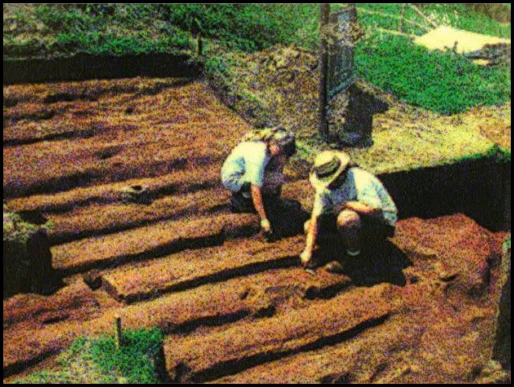
Aerial view of the Kelly-Larson dig in summer 1955
1953-1957 – The portion of the Tumlin Farm, where most mounds were located, was purchased by the State of Georgia in 1953. Arthur Kelly, then Chairman of the UGA Department of Anthropology, supervised excavation of test holes to determine the optimum locations to carry out full scale excavations. It was discovered that Warren K. Moorehead had misjudged the base of Mound C. The lower part of the mound was covered by 15 feet of silt from the 1886 flood, plus about 5-8 feet of silt from earlier floods and accumulation of human detritus.
Dr. Kelly obtained some form of tractor to remove the sod from the large plaza on the east side of Mound A. He was surprised to see very dark footprints from round houses varying from about 35 feet (10.7 m) to 50 feet (15.2 m) in diameter. There were also some rectangular structures. The surface strata of top soil contained a mixture of very fine Lamar (Creek) pottery and European Colonial trade goods.
The footprints of the round houses and square council chamber of the 1585-1700 AD occupation of Etowah by Apalachete elite are still visible in the color of grass on the plaza during certain times of the year.
Professors Kelly, Lawson and Joseph Caldwell didn’t know what to think. They had never associated round houses with the Creeks. None of them knew that the Apalachete elite lived in large round houses during the Colonial Period. There didn’t seem to be many artifacts below the houses, so they agreed to label it the Fourth Occupation of Etowah, but not excavate any future. The circular houses are still discernable due to color variations in the grass.
Dr. Lewis Larson was hired to supervise the excavation of the remaining part of Mound C. Dr. Kelly would supervise excavations on the plaza between Mound C and Mound A, plus continue examination of Mound B. Thus, the majority of significant Etowah artifacts, owned by the State of Georgia and on display in the museum, came from a rather minuscule portion of the archaeological zone. Visitors to the museum are not told this.
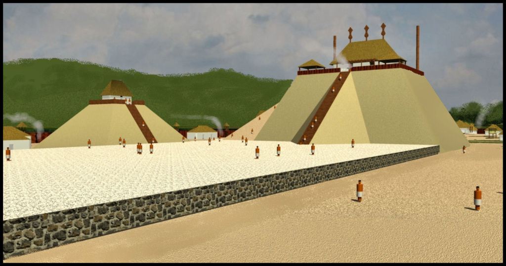
Dr. Kelly and Dr. Lawson told our architectural history class that the biggest surprise they had while working at Etowah from 1953 to 1957 was the diversity of architecture in the town. Both men had the stereotypical image of Native American towns being composed of small huts, all the same size and a few temples. This is how the commercial artists always paint Etowah.
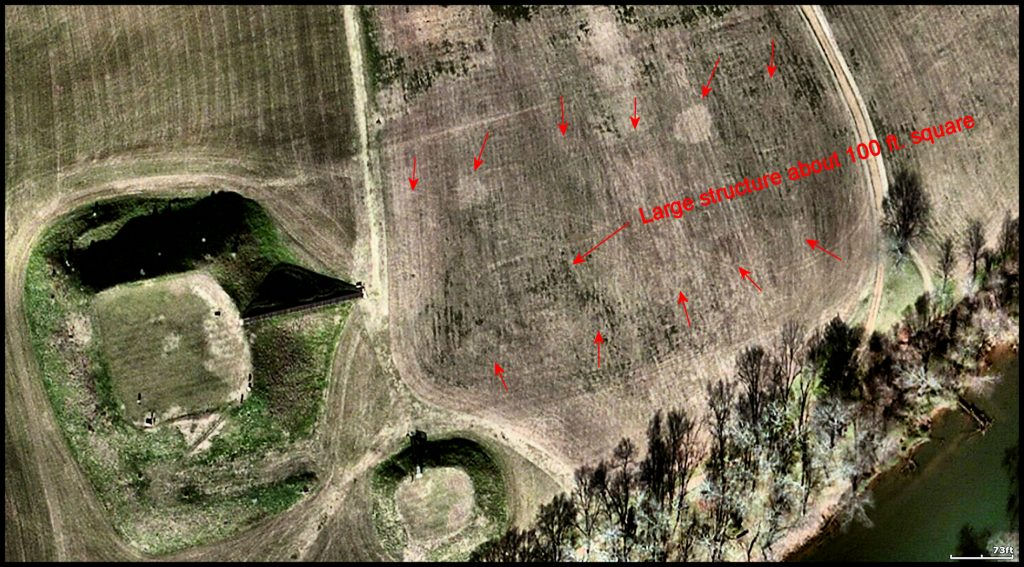
What these archaeologists unearthed instead were buildings of many different sizes and shapes. The largest building was a rectangular banquet hall or conference center, capable of holding at least 500 persons. It was located between Mounds A, B and C. It is not shown in any of the birds-eye paintings done by commercial artists, nor mentioned by museum exhibits.

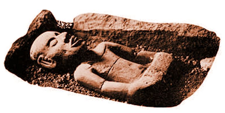
In August 1956, at the tail of end of the excavation program, Lewis Larson’s team made two astonishing discoveries at the base of Mound C. First, they encountered a large rectangular temple with fieldstone walls, mortared with mixture of clay and lime. Unfortunately, they realized that there was another building beneath it, so had to destroy the stone walls to continue excavation.
The temple beneath it was constructed with vertical logs like many of the temples of the “Olmec” civilization and Campeche Mayas in southern Mexico. Over time the roof of the log temple had collapsed under the weight of the earth above. The falling earth had knocked two marble statues – apparently of the founders of the town – to the floor of the temple. One of the statues had broken. On the floor of the temple were also the scattered, disarticulated bones of several humans. Lawson and Kelly never had an explanation for that macabre scene.
Stone wall around main plaza and East Ramp of Mound A
1995 – As part of his dissertation, Adam King, a doctorial candidate in Anthropology at the University of Pennsylvania, excavated the stepped eastern ramp of Mound A, prior to the building code-compliant wooden stairs being reconstructed.
The future Dr. King next excavated the edge of the main plaza. He discovered that the plaza was created by a stone retaining wall that was back-filled. This architectural feature is not mentioned either in the museum or illustrated in paintings by commercial artists.

Etowah Town Model (6 ft. x 8 ft.) for Muscogee-Creek Nation
2005-2006 – Etowah Remoted Sensing and Model – During the 1990s, the Muscogee-Creek Nation donated $5000 a year to the State of Georgia to support archaeological work on Creek town sites . . . in particular, Etowah. During an audit of the program by Muscogee-Creek Judge Patrick Moore, it was discovered that Georgia officials had been putting the donations into the General Budget then state employees would send make-believe descriptions of archaeological work that never happened to tribal officials.
Beginning in 2005 the MCN only funded specific projects. Therefore, $6,000 was contributed to support a remote sensing (aka ground radar) study of the entire Etowah town site. The MCN then contracted with me to build a world-class model of Etowah at its peak size (1375 AD). The model was to be based on the remote ground-sensing images of Etowah and thus work could not begin until the archaeologists had finished their work. The model would be temporarily on display at Etowah Mounds then moved to Oklahoma to sit beneath the Great Seal of the Creek Nation in the Rotunda of the Mound Building.
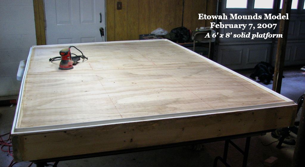
Building a model base of this scale was akin to designing a multi-story building. The base had to remain flat and square forever!
Dr. Adam King was responsible for the remote sensing imagery around Mound A. As always, Adam was very cooperative with both the Muskogee-Creek Nation and myself.
Another firm had been hired by the Georgia State Parks Division with the Muskogee’s grant, to survey the remainder of the site. They refused to even let me see their images, much less obtain a digital copy. The co-owner of the firm claimed that the images were his firm’s private property.
To this date, neither officials of the MCN nor Georgia taxpayers, who co-funded the study, have ever seen the work that they paid for. This childish behavior was equivalent to me refusing to give copies of my design drawings to the consulting engineers, working on the building that I designed. LOL
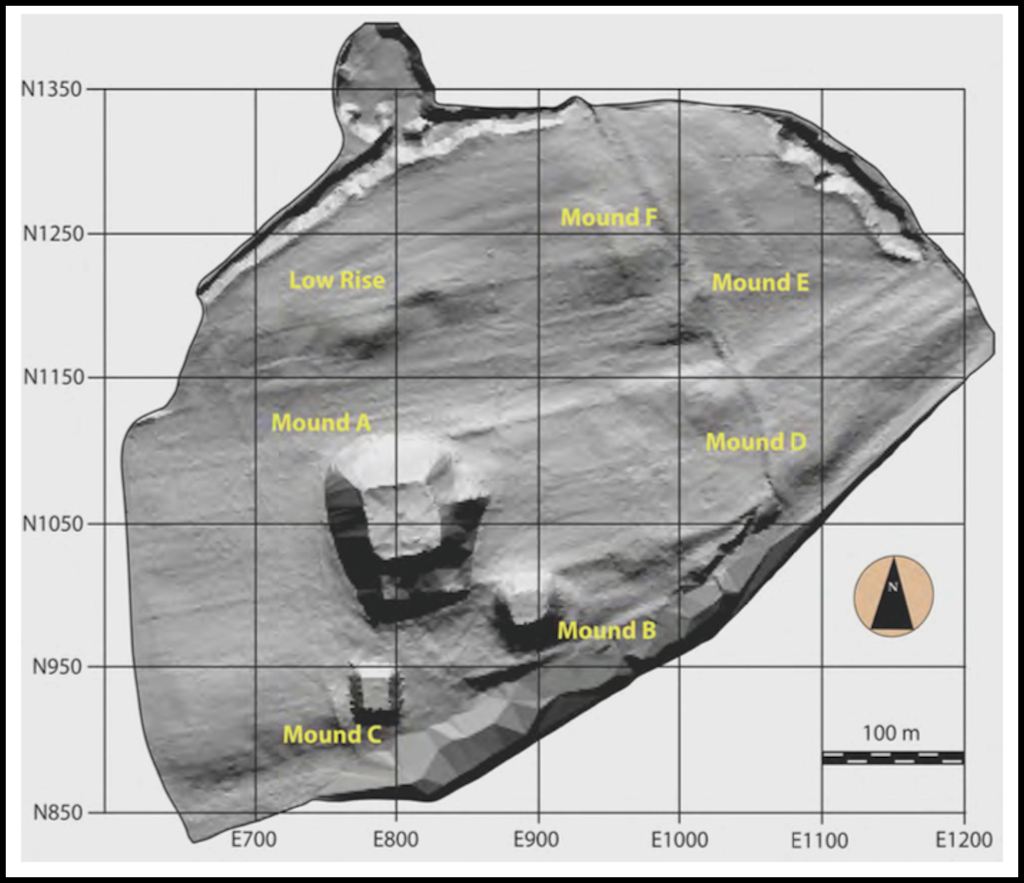
This is a remote sensing gradiometer image created by Duncan McKinnon for Dr. Adam King in 2009. Apparently, the original remote sensing consultants would not cooperate with Adam either. Once he had McKinnon’s imagery in hand, Adam was able to continue archaeological investigations at Etowah. He has generally concentrated on the mounds in the northeastern section of the town, which date from around 1375 AD to 1600 AD.
It was impossible for me to create an accurate museum model without accurate topography and locations of Native American structures. MCN Second Chief Alfred Berryhill contacted the U.S. Geological Survey. This agency agreed to provide me several spectrums of infrared satellite imagery at no charge. There was a delay, since we had to wait for the satellite to photograph the images, but it was worth the wait.
The military quality infrared actually showed me many more details than were shown on the remote sensing images. An Etowah Mounds ranger photocopied one section of the uncooperative archaeologists’ study, so I could compare the two types of remote sensing.
The model was finished on time in March. The site manager invited seven top officials of the Muscogee-Creek Nation to Cartersville for a fund-raising barbecue in April 2007. The MCN also invited Atlanta news media to the unveiling of the model at the Etowah Mounds Museum.
Would you believe? . . . Two weeks before the Creek Barbicoa, Georgia Parks Division Director, Becky Kelly, uninvited the top seven officials of the Muscogee Creek Nation. She cancelled transportation of the Etowah Model from my model-building shop to Etowah Mounds. She re-named the event, “A Woodland Feast” then invited two minor administrators of the Eastern Band of Cherokee Indians to be the guests of honor. There was something going on behind the scenes.
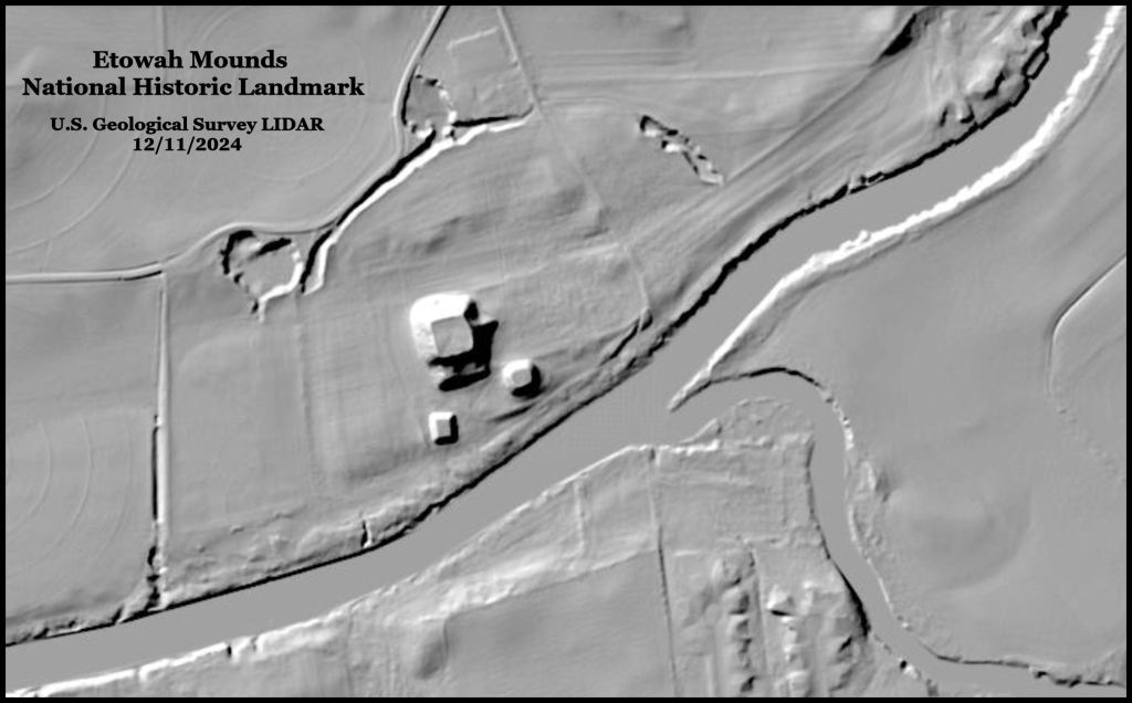
How the times have changed! Now, in a couple of minutes I can run a LIDAR scan on any archaeological site in the United States! Note how the USGS provides me finer details than were possible with several thousand dollars expenditure on a gradiometer scan in 2009.
In a later article in this series, we will tell readers about the bizarre, clandestine effort in Georgia between around 1991 to 2012 to re-label all of the ancestral Creek towns in Georgia to being Cherokee Heritage Sites. The Etowah Mounds National Historical Landmark was to be leased to a mega-millionaire for a dollar a year. He planned to tear down the existing museum then build a “Cherokee History” Museum, named after himself. A gated community of two million dollar houses, would ring the archaeological zone.
Until then . . .

WOW Such a fascinating post Richard. I shall read it again so as to absorb it all.
LikeLiked by 1 person
Thank you!
LikeLiked by 1 person
just unacceptable, the rewriting of actual history so someone can make a buck.
LikeLiked by 1 person