
We are going to make history come alive in 2025!
What was it like to live in that era, whether you were indigenous or a newcomer or a mixture of the two?
Over the past 20 years, I have collected enough historic maps and eyewitness accounts to fill in many gaps in the existing textbooks, plus correct a legion of faulty speculations made by 20th century academicians. Several of those folks just did not do their homework. I did!
During 2024, I devoted much of my time to creating accurate three dimensional Architectural CADD models of Colonial Period humans, animals, plants, tools, weapons and structures, which will be utilized in the virtual reality scenes.
by Richard L. Thornton, Architect & City Planner
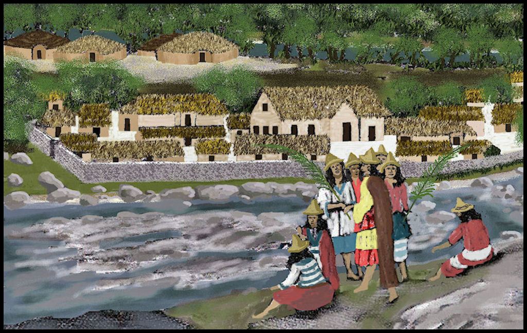
Image Above: This engraving, in a 1658 book by Charles de Rochefort, is a view of the confluence of Smith Creek and the headwaters of the Chattahoochee River, based on a sketch made by English explorer, Richard Brigstock, in 1653. The location is about a mile north of Helen, Georgia. The scenery there today is spectacular, especially near Anna Ruby Falls and Unicoi State Park, but not so dramatic as the Alps, as fancifully portrayed by De Leers. In the lower left hand corner is an equally fanciful portrayal of a fortified Spanish trading post and Franciscan mission, which I am current working on.
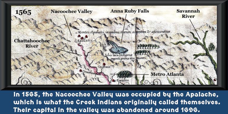
This is a section of the 1565 water color map of the lands of the Apalache by Jacques Le Moyne, resident artist and cartographer at Fort Caroline. His map was based on the field notes of Lt. LaRoche Ferrière, who spent six months, exploring what is now Georgia, northeast Alabama and western North Carolina.
Ferrière conducted a treaty between the Kingdoms of France and Apalache, whereby Captain René de Laudonnière would establish the capital of New France, where the University of Georgia is now located. Apalache and France would become commercial partners and military allies. De Laudonnière conceived New France as a new home for French Protestants, now living in regions of their realm, which were very hostile to Protestantism.
First, let’s explain the Kingdom of Apalache
The Apalachee Indians of the Florida Panhandle did not call themselves “Apalache” until the Spanish told them that was their name. The “faux” Apalache were Southern Arawaks from Peru, not Mesoamericans or Muskogeans. However, the real Apalache, from northern Georgia, did establish a large trading town, named Tula Hiwalsi on Lake Jackson near Tallahassee. Tula Hiwalsi means “Town of the Highlanders” in the Apalachete and Itstate languages (not Muskogee) spoken by most Creeks in Georgia.
The real Apalache were the most advanced indigenous people, north of Mexico. Their name appears on all maps of the Southeastern United States until the early 1700s, but I have found that contemporary academicians in the Southeast are totally ignorant of their existence. The plural of their name, Apalachen, evolved into the name of the Appalachian Mountains.
When Savannah, GA was founded in 1733, most Middle and Lower Creek tribes called themselves Apalache or Palache. Around 1748 they changed their name to Maskoki . . . a hybrid word that means “Mixed Ethnic Groups – People.”
According to the Apalache Migration Legend, they were originally one of the Panoan tribes, who settled along the coasts of Georgia and South Carolina. The actual Panoan name, Aparashe, means “From ocean (or Amazon Basin) – Descendants of”. They established the acropolis on the Ocmulgee River, now called Ocmulgee Mounds, then migrated northward to the headwaters of the Oconee River in NE Metro Atlanta.
According to the Kaushete (Creek) Migration Legend, the Apalache occupied the lower mountains in Georgia, when the Kaushete arrived there. The Itzate controlled the higher mountains in Georgia and North Carolina at that time, but by around 1585, the Apalachete controlled both regions.
After acquiring firearms and horses, the Apalache created a confederated kingdom that stretched from northeastern Tennessee to southwestern Georgia. This confederated kingdom disintegrated, after the horrific 1696 AD smallpox plague and the 1700 AD eruption of the Chimney Mountain Volcano, about seven miles north of my house. My property’s soil contains young lava bombs, pumice rocks and volcanic ash.
From the comments by Richard Brigstock and the engravings of Arnout de Leers, we know the origin of the brightly colored traditional clothing of the Seminole and Miccosukee. The men wore tunics that are now called “Creek Long Shirts.” They wore kilts while hunting or battling in warm weather. The women wore tunics, blouses and dresses. In the hot summer months, both genders went topless.
Men, who were veterans of warfare typically wore mustaches. Elders and leaders also wore beards. The elite men wore shoulder-length hair, but warriors, farmers and laborers normally wore their hair in buns. The women wore a broad variety of elaborate hairstyles, but while working typically wore pony tails or pig tails, woven into buns.
In sunny weather, both men and women wore conical hats, woven from split river cane or certain wild grasses. There are some shell gorgets showing ancestors of the Creeks wearing these conical hats, but this fact has been ignored by academicians.
The modern Creek Confederacy was established at Ocmulgee Mounds in 1717, under the dominance of the Muskogee-speaking Coweta and Tuckabatchee tribes. It included all the members of the Apalachen Confederacy, except the tribes allied with the Cherokee, who were now arch-enemies. It also included the Chickasaw, but they soon dropped out, because of the requirement that Muskogee be used in all political meetings.
