
. . . from a fanciful Dutch engraving, published in 1658!
In 1848, the earthen ramparts of the adjacent Spanish fort were still visible and described by Charles Lanman from the Library of Congress.
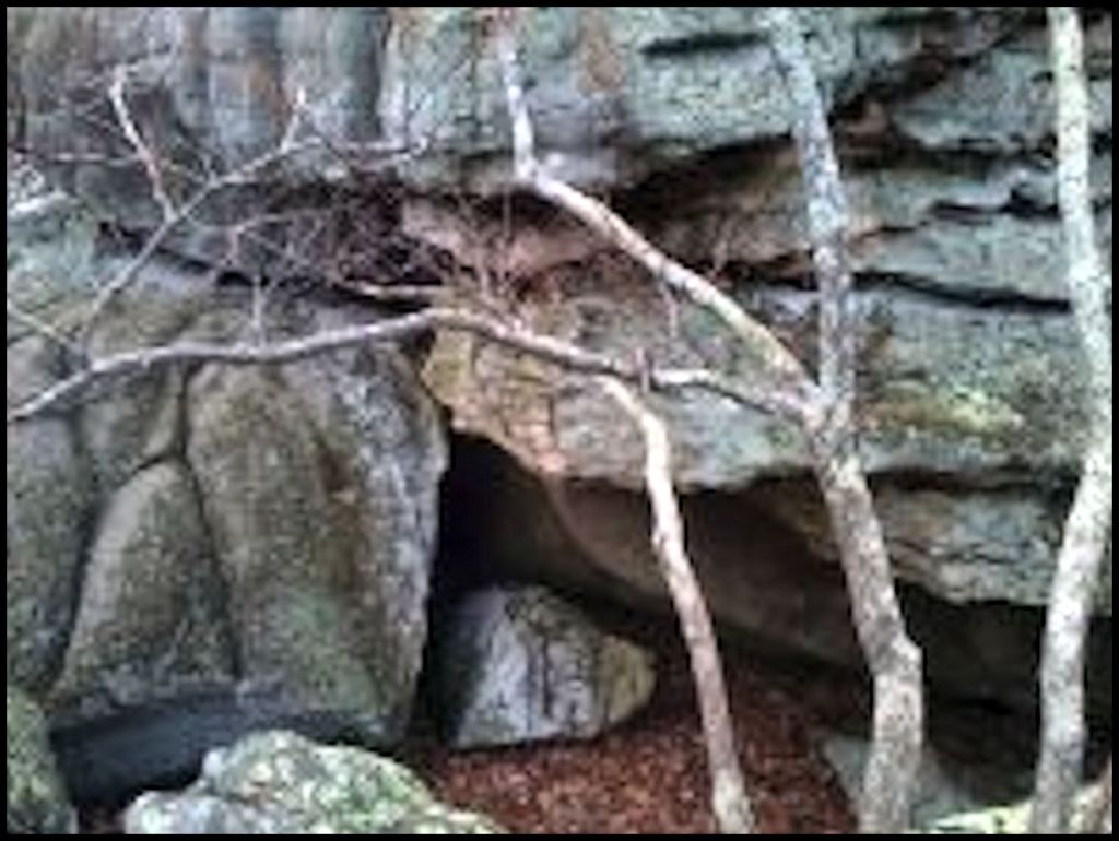
The Spanish Colonial compound was located on a terrace overlooking the intersection of Georgia highways 75 and 356 . . . in the Robertstown Community between Helen, GA and Unicoi State Park. Smith Creek and the headwaters of the Chattahoochee River join in the valley beneath this terrace.
by Richard L. Thornton, Architect & City Planner
In the Georgia Gold Belt, 440 to 330 year-old Spanish gold mining symbols can be found on boulders near major trade paths.
A Spanish Gold Mining Map in Cobb County, GA
It was in 1995 that I first realized that my Eighth Grade Georgia History textbook had left out many chapters from Georgia’s past. I was Principal Planner for Cobb County, GA and had been primarily hired to prepare an Urban Design and Economic Revitalization Plan for the Atlanta Road Corridor from the I-285 Perimeter Hwy. to the county seat, Marietta. I was also responsible for the administration of the many Civil War battlefields, archaeological sites and historic buildings in the county of 600,000+ residents.
Three hikers came by my office. They had discovered “Indian Petroglyphs” on boulders along Nickajack Creek, which flows to the Chattahoochee River in the southern half of the county. I didn’t believe them, but it was beautiful June day and I wanted to get out of the office.
Indeed, there were petroglyphs carved into the granite boulders along Nickajack Creek! However, some of the symbols were Roman letters and various types of crosses. On the northern end was what appeared to be the symbols for a fort and a church. There were many turtles, plus some other animals, so Native Americans had been involved with these rock carvings. There had been a Spanish fort and church somewhere near Kennesaw Mountain.

The miners from northwestern Iberia used turtle symbols to guide visitors to a gold deposit or gold panning location.
Cobb County is in the Georgia Gold Belt. We eventually decided that this was a Spanish gold claim. Florida Apalachees had come along as porters and laborers. They carved the symbols of their clans. Only about six weeks later, I “jumped ship” and became the planning and urban design consultant for implementing the Downtown Smyrna Revitalization Plan. These petroglyphs were filed in my low-priority brain archives.
Twenty-four years would pass before I understood the full meaning of the Nickajack Petroglyphs. It was a Spanish mining claim to all of the Upper Chattahoochee River Basin. All of the symbols, including the animals, were used by gold miners from Galicia, Asturias and Navarre to mark mining claims and give directions. The symbols had evolved from an ancient Ibero-Celtic writing system. The fort and church were somewhere near the source of the Chattahoochee River, but where? There is no mention of either in the official Georgia history books.

Fanciful engraving of the mission and fortified trading post by Arnout Leers of Rotterdam, based on a sketch by English explorer, Richard Brigstock . . . drawn in 1653. The portrayal of the clothing of the Apalachete-Creek Indians in the foreground is accurate.
Not such fancy architecture
The engraving above was based on a sketch by Richard Brigstock in 1653, which was forwarded to the printer in Rotterdam. Apparently, the sketch showed a walled village with numerous buildings of various shapes and forms. Arnout Leers interpreted the sketch as prosperous, mid-17th century Dutch town. No way.
The only building materials would have been derived from local trees, field stones and clay. Most of the Spanish buildings would have looked little different than the Apalachete buildings.
The Spanish loved to apply white lime stucco to their buildings. However, the nearest limestone was on the other side of the Blue Ridge Mountains, 45 miles (72.4 km) to the west. Lime burning is resource and labor intensive. It would take many 90-mile round trips by pack mules to haul enough lime to plaster even a small chapel.

Detail of the 1684 map of North America by Jean Baptiste Franquilin: The La Cota Pack Mule Trail connected St. Augustine with the headwaters of the Chattahoochee River and then the confluence of the Tennessee and Little Tennessee Rivers at Bussell Island. “La Cota” means “The Sleeve” in English. That name came from a narrow gorge, east of Sal Mountain, where the road followed the east bank of the Chattahoochee River, thus enabling it avoid any major river crossings all the way to St. Augustine.
A long distance from anywhere
To put things in perspective, in 1653, the two nearest European two towns of any size to the trading post and mission on the Chattahoochee River were St. Augustine, FL and Jamestown, VA. The trading post and St. Augustine were connected by a pack mule trail over 480 miles in length. St. Augustine had a population of 550 people. To the north, Jamestown was about 509 miles (820 km) away, but there was no continuous connecting road and Jamestown only contained around 350 people. New Amsterdam had a population of around 1,000, while Boston’s and Quebec City’s populations were about 2,000. New Orleans, Savannah, Charleston and Philadelphia didn’t exist.
The Nacoochee Valley Area in 1653 had a population of about 2,000 people with around 7,000 warriors living within two days walk of the Apalache capital, according to Richard Brigstock. This would suggest a regional population of about 30,000 people. The Nacoochee valley was a major metropolis of North America in 1653!

Much colder and longer winters
In an earlier article, we discussed the distinctly different climate of the Southern Highlands during the Colonial Period. All of the other Franciscan missions in present-day South Carolina, Georgia and Florida were in locales with sub-tropical maritime climates. The light-weight, early architecture in these locales was totally impractical in the “Apalachen” mountains of northern Georgia. Back then the snow stayed on the ground from December to late March. The buildings had to be heated and the food cooked indoors for several months. For more information on the climate back then, go to:
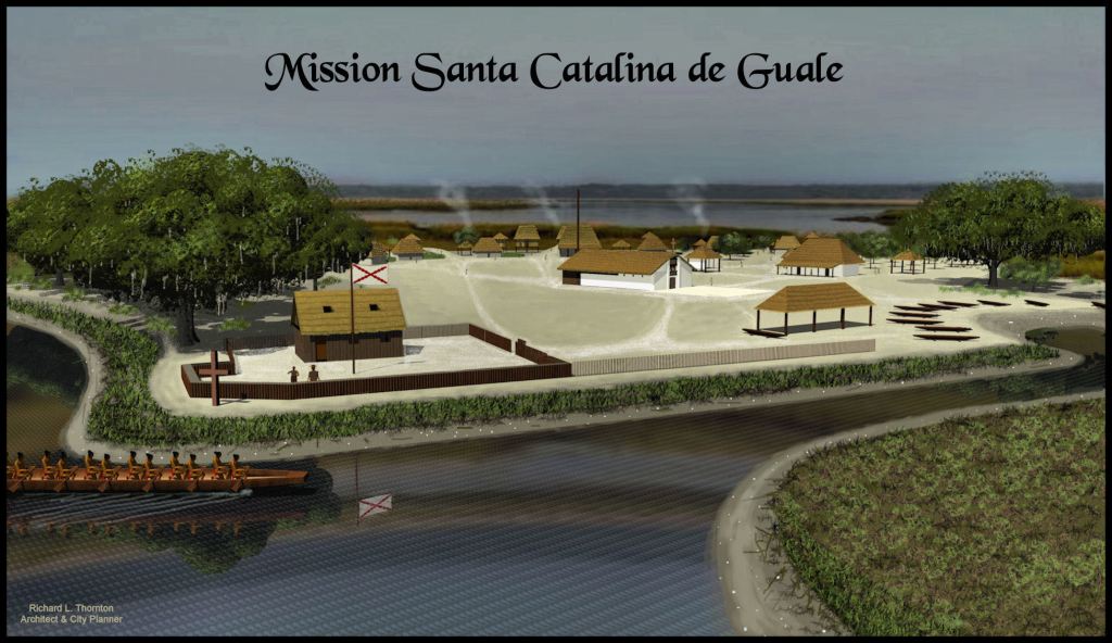
View of the mission after a casa fuerte and palisade were constructed to help prevent attacks by pirates and Native American raiders.
Mission Santa Catalina de Guale
In 2007, I was retained by the American Museum of Natural History to prepare architectural drawings of their discoveries on St. Catherines Island, GA. I was fairly knowledgeable of Spanish Colonial architecture in Mexico, but knew diddlysquat about what the Spanish built in the Southeast. Thus, the archeologists at the AMNH required me to digest two cardboard boxes filled with archaeological reports and photocopied Spanish archives, before I drew one line for the mission.
I was surprised to learn that although construction of the mission was supervised by an architect in the Spanish Army, most of the construction details were consistent with traditional Native American architecture in Georgia. In fact, the convento for the friars was identical the house of the chief of the adjacent village. It contained three rooms and had a covered front portico, like the houses of village chiefs in the Maya lands. The only significant construction materials, exclusively reflecting European technology were the iron door hinges and nails holding doors panels together. In his report, the architect stated that the Guale people knew how to make hydrated lime and regularly applied lime stucco to their buildings.

Fortified Spanish trading post in the Florida Panhandle
Spanish trading posts in the mid-1600s
Governor Don Benito Ruiz de Salazar Vallecilla, the same man, who developed the combined trading post, mission and mule-breeding facility on the Chattahoochee River Headwaters, also built a short-lived mission near present-day Columbus, GA. It was destroyed by the Creek Indians about two years after construction. There is no mention of a trading post here. Academicians in Georgia and Florida, who come across correspondence between St. Augustine and the complex in northeast Georgia consistently assume that they are referring to the Columbus Area mission, even though the records long post-date its demise.

Terrain map of Fort Apalachicola site, 15 miles south of Columbus, GA
There is only one fortified trading post, recorded as being built by Spain within the interior of the Colony of Georgia’s Coastal Plain and Piedmont, despite Georgia being one of the most densely populated regions of North America in the 1500s. Fort Apalachicola was built by Governor Don Diego De Quiroga y Losada in 1689, about 15 miles (24 km) south of present-day Phenix City, AL and Columbus, GA on the west side of the Chattahoochee River.
The governor acted without approval from the Spanish king, because English traders from Charleston and environs had begun to settle and conduct business with local Creek and Uchee Indians, immediately north of Spanish missions in the Florida Panhandle. Until 1804, Alabama was part of Georgia.
Fort Apalachicola was hastily built of sawn logs as a square palisaded structure with bastions at each corner. Each bastion contained a small canon. As seen in the infrared scan above, a casa fuerte sat in the middle of the plaza. The entire site measured approximately 72 feet (22 m) across from the center of the moat on one side to the center of the moat on the other side. When King Carlos II learned of the fort’s construction in 1691, he ordered it dismantled, because it was too far from Florida to be defended.
The reason for the sparsity of Spanish trading posts in Georgia was that the Native peoples within the interior of Georgia liked the French explorers, who visited their provinces, but from day one, they were extremely hostile to the Spanish. The original Spanish mission system never penetrated very far from the ocean and was completely abandoned by 1680 . . . except for the mission at the headwaters of the Chattahoochee River. Perhaps by then, it was gone also. We will probably never know.
Compared to Georgia, the Florida Peninsula was very sparsely populated by indigenous peoples. That is why Spain was able to dominate the peninsula with rather a minuscule number of soldiers. Some trading posts were built, but never in conjunction with a mission and hacienda, as in the Nacoochee Valley.
Sketches of a couple of Florida trading posts can be found online. Those in Florida consisted of a timber palisade around a casa fuerte. A casa fuerte was a heavy timber, barn-like structure, which functioned as a fort, warehouse and barracks. When a Carolina militia army invaded the Florida Panhandle in 1705, these trading posts were the sites of battles with the small garrisons of Spanish soldiers and armed Florida Apalachee militia tried to hold off the much more numerous armies composed of Carolina militia and Native American allies.

Seventeenth century French trading posts
The 1715 Beresford Map, drawn in Charleston, was the first map to show the Cherokee living in Southeastern North America. It also shows a French fortified trading post on Bussell Island in the Tennessee River. This is where the Unicoi Trail from the Spanish trading post on the Chattahoochee River terminated. I strongly suspect that there was a fortified trading post built by the Spanish here, when they improved the existing foot path to handle pack mules in the late 1640s.
This French fort is so far removed by canoe travel from Quebec that its only possible source of European larger goods would have been the larger fort on the Chattahoochee River. During that era, France and Spain had become allies in order to challenge the growing sea power of Protestant Great Britain, the Netherlands and Sweden.
This fort was excavated In 1887 Smithsonian Institute (amateur) archaeologist, J.W. Emmert. He described the fort as a four-sided log palisade built over two Indian burial mounds. On each corner was a log-walled bastion. He made no mention of a central casa fuerte, but in truth, he had no formal education in archaeology or anthropology.
Emmert unearthed thousands of 17th and early 18th century European artifacts, but discarded them, since he was primarily looking for trophy Native American artifacts, which the Smithsonian could put on display or give to politicians and wealthy donors. He found very few artifacts of possible Native American origin above the two burial mounds.
In the 20th Annual Report of the Bureau of American Ethnology, Emert described his discoveries on Bussell Island as a “walled Cherokee village built over two Cherokee mounds.” Note that the 1715 map shows all of the Upper Tennessee River to be occupied by Cusatees (Upper Creeks).

Fortified French trading post near Tabousec, Quebec – note the chimney, which is not seen on Spanish casa fuertes. I decided not to show a chimney on the one in the Chattahoochee Valley. I instead assumed that during the winter, the garrison, mule skinners and laborers lived in simple, one room houses with fireplaces and chimneys.
Until European diseases greatly diminished their numbers, the indigenous population density of the St. Lawrence River Basin was much higher than in La Florida. Furthermore, the economic base Nouvelle France was the fur trade. The French build numerous trading posts in Canada. The larger facilities also included a mission, staffed by a Jesuit priest.
The climate and vegetation of southern Quebec in the mid-1600s was much more similar to that of the Georgia Mountains than was the Coastal Plain of Georgia. The primary difference between Quebec and the “Apalachens” was the length of the growing season.
In drawings or photos of reconstructed trading post-missions, we see much more solidly built structures in Nouvelle France. We see barn like structures very similar to the casa fuerte in Spanish trading posts and forts. The drawings show log palisades around all facilities. Some of the restored or rebuilt trading posts do not have long palisades, but originally did.

This is the appearance of the old mission market plaza in Matajay, Philippines. A century later, the original chapel has been replaced by a more elaborate church, but despite having the intimate spaces of the original mission, the plaza still functions as the social-commercial center of the town.
Trading posts and missions in the Philippine Islands
While working on my book on early Colonial architecture, Earthfast . . . the Dawn of a New World, I discovered some fascinating facts. La Florida and the Philippine Islands were initially colonized by Spain at exactly the same time. Furthermore, the structures, erected by the Spanish army and initial missionaries were standardized by architects in Spain then published in a book, issued to Spanish officers. The big difference occurred after a decade or so of colonization. La Florida permanently remained a “step-sister” impoverished province, while Spaniards in the Philippines soon lived in a “cash cow.”
(The printed book also published by Lulu.com. It’s now $105, because of the number of full color images.)
The first Spanish settlement in the Philippine Islands was established in 1565 by Miguel López de Legazpi, who landed in Cebu. This expedition was in response to the Spanish government learning that the Emperor of China had decreed a switch from copper and paper currency to silver coins. There was a silver shortage in China, so Spain experimented with sending treasure galleons from Acapulco to China, laden with silver. Later, Manila became the trading center for silver with Chinese luxury items. Eventually, 70% of the silver, produced in Mexico and Peru went to China.
During the mid-1600s, when the government in Manilla began efforts to Westernize the technologically primitive tribes in the mountains of Mindanao, no soldiers could be spared, so they relied on friars to develop trade and cultural interchanges with the urbanized populations near Manilla. Because of the scarcity of Spanish officials in the Philippines, most often the friar missionary was the only non-military Spaniard in a town. Aside from his religious activities, the friar also had authority in administration of the colony. He collected taxes. Maintained a census and administered the market. This sounded quite similar to the situation at the mission on the Chattahoochee, except the Apalachete had a strong, sophisticated government. The primary non-clerical role of an isolated friar would be promotion of trade.
Indeed, what I found in drawings of the combination mission-trading post in the mountains of the Philippines was a market plaza, immediately outside the gate of the fort. On one end was the chapel. On one side of the plaza was the convento and supportive buildings. On the other end was an inn for indigenous traders, porters and travelers. Open sheds along the edge of the plaza were occupied by indigenous traders. This is the concept I presented in the speculative plan of the mission on the Chattahoochee headwaters.

Birdseye view of the entire mission compound
In following articles of The Americas Revealed, we will introduce readers to different parts of the mission compound, and explain how the world of the indigenous people living nearby was changing in 1653. By the early 1700s, when the first maps were made, a town of mixed-race residents was growing up around the fort and former mission site. It was called Chote.
