How I originally stumbled upon the Mesoamerican-North American linguistic connection. However, the real proof is in our DNA.
The problem was that few North American anthropologists were aware of the complex, diverse cultural heritage of Mexico, when they unearthed artifacts in the Southeast or in the Arkansas River Basin of Arkansas, Oklahoma and Kansas. Also, they never bothered to translate the names of tribes . . . or else relied on the inaccurate speculations of Anglo-American scholars in the past.
Now, genetics labs are finding high levels of DNA test markers, typical of southern Mexico, among descendants of several southeastern North American tribes, especially among the Creeks, Seminoles, Chickasaws, Cherokees along the Hiwassee River in North Carolina and southern Louisiana tribes. Southern Mesoamerican DNA markers predominate among Eastern Creeks and Seminoles. All of the Amer-Indian DNA markers in my paternal and maternal family sides (from Georgia) are either from southern Mexico or eastern Peru.
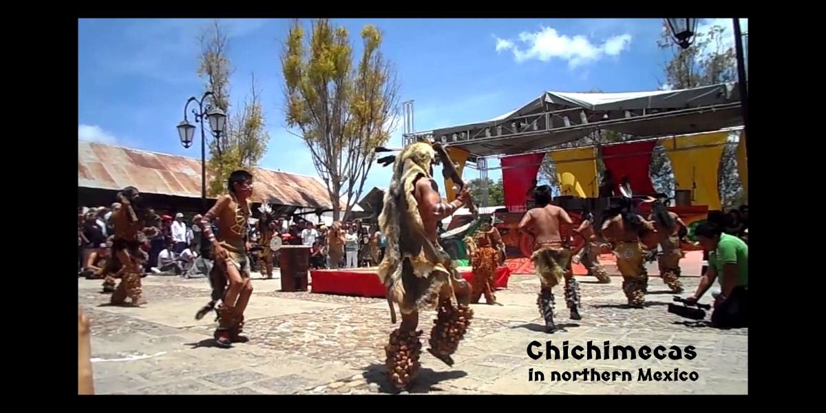
However, DNA markers, typical of the Mexican states of Colima, Nayarit, Sonora and Jalisco can be found in some Cherokee families, plus some Oklahoma Creeks, whose ancestors lived in southeastern Alabama. Indigenous peoples in northwestern Mexico were mostly in Chichimeca, Otomi and Cora-Huehol tribes.
The Mayas in Georgia Series
by Richard L. Thornton, Architect & City Planner
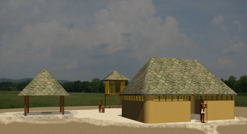
Typical house at the 9CK1 town site on the Etowah River near Ball Ground, GA
Readers of our next and final article in this series will be shocked at how widespread Mesoamerican words are found east of the Rocky Mountains in North America. Maya words are concentrated in Georgia, eastern Tennessee and western North Carolina, but you will be seeing linguistic proof of immigration from either southern Mexico or northwestern Mexico in many states and even the Province of Ontario.
Prior to providing readers a long list of words, I thought it necessary to explain how I discovered the linguistic connections between Mexico and eastern North America. It was NOT during the five visits to Mexico, but much later, while I was living in Jasper, GA.
Very frankly, it was all I could do in 1970 to quickly learn enough Spanish to survive, while traveling alone through the boonies of Mexico. Back then, few Mexicans spoke English outside of Mexico City and the hotels of larger cities. At hotels near archaeological sites not on the radars of travel agencies, it was a rarity for someone from the United States or Canada to even stay there.
All five trips to Mexico involved unforgettable romantic experiences, when I wasn’t studying ancient buildings . . . culminating with a week in Mexico City with Susan Karlson in 2000. It just never dawned on me to compare indigenous languages of Mexico and the United States, especially when much more enticing opportunities were at hand.
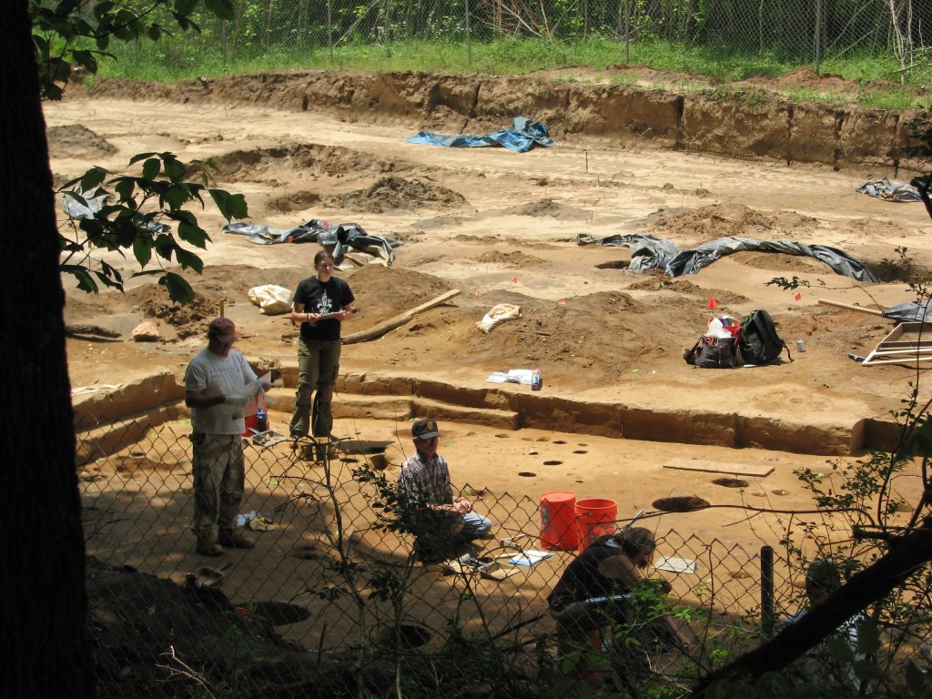
Archaeologists from Edward-Pitman excavating a typical house at 9CK1.
In 2006, I began watching the excavation of a large town site on the Etowah River near Ball Ground, GA . . . which was about five miles from my house. The archaeologists from Edwards-Pitman Environmental, were gracious enough to let me stand near them as they worked.
I noticed that both the thick walled winter houses and river-cane-walled summer houses at 9CK1 were identical to Totonac houses that I had seen under construction in northern Veracruz State. They were different than the corner-door houses at Etowah Mounds. Out of curiosity, I looked up the word for “casa” in an online Totonac dictionary, posted by the Universidad Nacional Autónoma de México (UNAM).
Holy Toledo! It was chiki! . . . the same word used by Seminoles for a house and by Muskogee Creeks for a summer house. The UNAM website enabled me to cross-reference indigenous Mexican languages. I quickly realized that the words in Totonac that meant the same in Creek languages were also in the Itza Maya and Highland Maya languages. Choko . . . the Itsate, Muskogee, Chickasaw, Choctaw and Alabama word for winter house, meant “warm” in Itza Maya.
Then . . . in 2007 the American Museum of Natural History required me to digest two whole boxes of photocopied Spanish Colonial Archives and archaeological reports prior to drawing a single line of the mission and Native American buildings on St. Catherines Island, GA.
The friars and Spanish officials clearly placed Fort Caroline on the south side of the mouth of the Altamaha River IN GEORGIA not on the St. Johns River in Florida. They also complained of repeated slave raids by Chichimec raiders against the many Franciscan missions in Georgia. They stated that the Chichimecs came both by land and by sea.
Gringo archaeologists and historians scoffed at the idea of Chichimecas from northwestern Mexico raiding Spanish missions in Georgia, but the Spanish authors and Georgia Indigenous sources provided details, which sure sounded like Chichimecas. I looked at the mystery, closer.
The Creeks called these raiders, Ue-este (Water Men) which became their feared name, Westo, among Carolina colonists. They said that these strangers had long hair and were savages. Indeed, in modern Muscogee Creek, Ueste or Weste is an adjective, which means “long, scraggly hair.”
Virginians called these raiders, Rickohockens. It is a Late Medieval Dutch word, which means roughly, “Lords of the Highlands.” The Virginians said that their capital was Otari in the Blue Ridge Mountains near present-day Bedford, VA. They also described the Rickohockens as having long, unkempt hair.
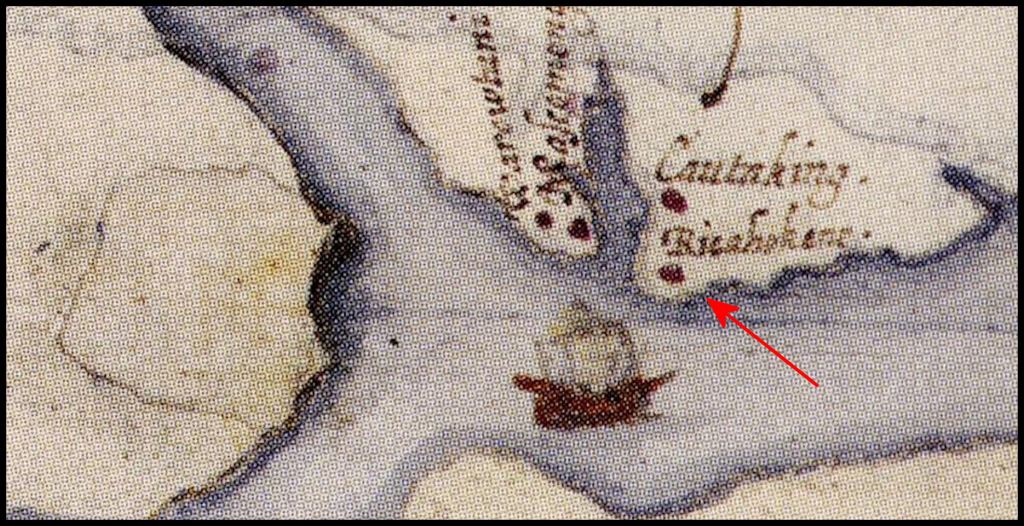
No one else seems to have noticed that there was a Rickohocken village near the proposed location of the permanent Roanoke Island Colony fort. It was on the shore of Albemarle Sound, not in the Blue Ridge Mountains like the Rickohocken capital, Otari.
I did some more research on the internet. This was much easier back in 2007 than in the commercialized version of Google now, which gives first priority to what are essentially, paid advertisements. Dutch sources mention that Sephardic merchants and ship captains, now based in the Netherlands, were heavily involved in the Native American slave trade. Initially, they illegally purchased Chichimeca slaves from Sephardic Crypto-Jews living in northern Mexico.
However, after those Crypto-Jewish slave catchers were burned at the stake by the Inquisition, the Dutch Sephardic slave dealers used their Chichimeca slaves to make contact with “wild” Mexican Indians living in the interior of eastern North America. These Indians were then armed and trained to become slave catchers. Obviously, if Chichimeca slaves could converse with these “wild Mexican Indians,” they were also originally from northern Mexico.
However, there is more to the story. Maps drawn by Samuel Champlain and also cartographers in the Netherlands, during the first half of the 17th century, show a tribe living in what is now southern Ontario, with a pure Nahua name, which is the same as a Nahua-speaking Chichimec tribe in Mexico today! Samuel Champlain wrote that they were catastrophically defeated by the Iroquois Confederacy in 1649 AD. After 1650 AD, French and English maps showed that the survivors had migrated to what is now southern West Virginia, the southwestern tip of Virginia and northeastern tip of Tennessee.
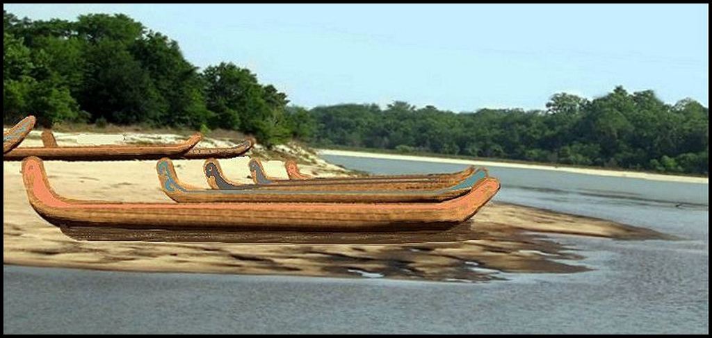
Itza Maya style canoes on a North American River
The “Major Players” of Mesoamerican immigration
In order to prepare readers for the list of Mesoamerican words, here is a description of the Mesoamerican ethnicities, which appear as words on North American maps.
(1) Tamahiti (merchants in Totonac & Itza Maya) – Tama means “trade” or “commerce” in these languages. It is known that Teotihuacan sent out merchants, which the Aztecs later called potecas to all regions of their known world to acquire minerals unavailable or rare in Central Mexico.
Teotihuacan used vast quantities of attapulgite in its murals between around 100 AD and 600 AD. The nearest and only major source for attapulgite within 4612.5 miles / 7423 kilometers was the Chattahoochee River Basin in present-day Georgia and the northwestern tip of Florida.
Totonac cities continued to use attapulgite from 600 AD to around 1200 AD. Palenque in the Chiapas Mountains utilized attapulgite from roughly 250 AD to 800 AD. Maya architects in northern Yucatan, Campeche and Tabasco utilized attapulgite from around 250 AD to 1500 AD.
The Maya cities in southern Mesoamerica also used vast quantities of mica in construction, murals and cosmetics. Their nearest major source of mica, accessible by watercraft, was also the Chattahoochee River Basin.
(2) Chontal Mayas – This is the generic Mexica (Aztec) name for the maritime tribes living on the Gulf Coast of Mexico, after they conquered much of the region. By this time, the Chontal Mayas spoke several distinct dialects, which mixed Itza Maya with local tongues.
(3) Tamauli (trade people or merchants in Huasteca) – These were mixed-heritage Chontal Maya-Huasteca merchants, based in Tampico Bay, Tamaulipas. Tamaulipas means “Trade People – Place of.” The name appears in southwest Georgia and the Florida Panhandle as missions for Catholicized Creeks, who formerly lived along the Altamaha River in Southeast Georgia.
(4) Mapile (trade people in languages of northern Veracruz) Spanish explorers on the northern Gulf Coast modified the word to Mabila, which became Mobile in French and English.
(5) Tamatli – (trade people on central and southern Veracruz Coast) – This is the version of the word, used by Chontal Mayas, who spoke a language that mixed Itza and Nahuatl words. It was also names of Native American towns in western North Carolina and eastern Tennessee.
(6) Potun or Potuno – Merchants based on the Island of Jaina, off the coast of Yucatan and at Am Ixchel on the northern tip of Yucatan. The name appears as a powerful province along the Savannah River near present-day Augusta, GA and as a town name in north-central Florida.
(7) Teononetecas – (Silent God People in Nahua) – This Chichimeca tribe possibly began as a religious cult, who worshiped a strange god, who could neither speak nor hear. They built a pyramid and temple in Tlatelolco, one of the three cities in the Aztec Triumvirate. You will see it in the next article. Their name also appears on French maps along with their vassals, the Charioqui’s, until 1649 . . . then on maps of Virginia until the early 1700s. Say what?
Need more proof?
Because Chontal Maya traders provided a critical service to the city states and empires of Mesoamerica, they could travel by land or sea with impunity. So, they would not be mistaken at a distance as enemies, they wore Raccoon Skin caps, whose tails dangled down their necks and and upper torsos.
Yes, really! Uchee and Itsate Creek traders in eastern North America also wore coonskin caps . . . for the same reason. British frontiersmen picked up this fashion statement from the Native American traders.
Archaeologists, working at the Spiro Site in eastern Oklahoma near the Arkansas River, excavated exquisite stone figurines and tobacco pipes that looked mighty Mesoamerican . . . which they dared not say, unless they wanted to be burned at the stake by their fellow archaeologists. Two samples of Spiro art particularly stand out. One portrays a Mesoamerican ball player, cutting off the head of an opponent. The other portrays a man, wearing a coonskin cap . . . a Tamahiti trader.
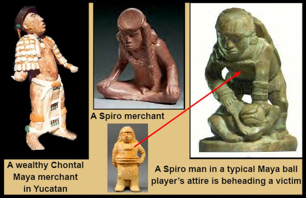
Note the fancy coonskin caps on both the merchant from Jaina Island, Yucatan and the redstone figurine, unearthed in Spiro, Oklahoma.
+
The Truth IS out there . . . and it is on display in museums.

Thank you for this. I am on the same basic trail as you, to prove connections in pre-contact Americas. I am working on my 6th copper artifact resource manual and find no reason to deny these contacts. If it’s okay, I’d like to share a quote from you in this newsletter, as I will be talking a little more about copper flakes found that indicate the use of a parrot head walking staff, from as far away as West Mexico, via Spiro. One was found in Arkansas but I’ve been unable to track it down. Other ‘flakes’ are found at Cahokia and up into central Wisconsin. And there’s more. So much more.
LikeLiked by 1 person
Yes, Monette! Anything in The Americas Revealed is public information and can be shared. I often have professional projects, which can’t be divulged to the public without permission of clients, but they won’t be discussed here in detail. Wish you the best in your research efforts.
LikeLike