
The answers to 17-year-old riddles from 2007 were to only come after I translated the Native American place names along the Georgia and lower South Carolina Coasts. Most of those words originated either in the Upper Amazon Rain Forest or the Caribbean Basin.
C. 2007 – The residential architecture of this village, unearthed by archaeologists from the American Museum of Natural History, was identical to that of the Non-Maya maritime peoples, who colonized the coasts of Tabasco and Campeche States, while its site plan is identical to many villages in the Amazon River Basin. How can that be?
The South America and Caribbean Basin Series
by Richard L Thornton, Architect & City Planner

The indigenous people of St. Catherines Island had two residences. One was in a formal circular pattern in the village. The other was in a dispersed farmstead associated with an approximately one acre garden. Most of the carbohydrates were obtained from highly edible Live Oak acorns. The farmsteads were associated with massive Live Oak Orchards and the tidal marshes . . . a bountiful source of seafood.
2007 – In my initial phone call with the archaeologists at the American Museum of Natural History, I explained that my fellowship in Mexico was focused on the Pre-Columbian Architecture. I usually photographed 16th and 17th century churches and monasteries that I encountered in Mexico, but had absolutely no guidance from my fellowship coordinator, Dr. Román Piña Chán, concerning the Colonial Monastic Architecture of Mexico.
I suggested that the AMNH contact a fellow architect in Sante Fe, New Mexico, who had pioneered the use of CADD in documenting the ruins at Chaco Canyon, but initially developed his technical skills on old Spanish missions. They responded that all of the Indigenous and mission buildings on St. Catherines Island were constructed by local Indians, but had construction details, typical of Creek buildings farther inland in Georgia. That is why they contacted me in the first place . . . not my educational experiences in Mexico . . . however, my ability to read Spanish was an asset.
The AMNH sent me two boxes of photo-copied archaeological reports and Spanish archives from the 16th and 17th centuries. I was instructed to read these documents before ever drawing a single line.
Reading those documents was one of the most significant educational experiences in my life. I quickly realized how starkly the actual eyewitness accounts of the Early Colonial Period varied from the version of North American History that we are taught in high school and in university textbooks.
I was particularly shocked that Fort Caroline National Memorial on the St. Johns River in Jacksonville, FL is a complete fraud, foisted upon the United States Congress in 1951 and maintained by Florida’s academicians to this day. According to the reports of several friars sent to their bishop in Havana, Mission Santo Domingo de Talaxe and the adjacent ruins of Forts Caroline and San Mateo were a partial morning’s canoe ride south of Mission Santa Catalina.
At least as late as 1670, the Spanish did not even know that the St. Johns River existed. San Juan was initially the name of Amelia Island! Until the 1820s, even the occupants of Native American canoes had to get out of their canoes and WALK through the shallow waters of the St. Johns’ mouth. The St. Johns River was not accessible to sea-going vessels until 1860.
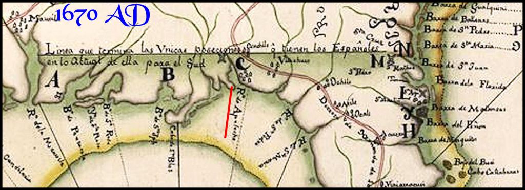
This information caused me to look very closely at the available French and Spanish archives in those two boxes, sent me. All French, Spanish, English and Dutch colonial era maps placed Fort Caroline in present-day Georgia. The formal reports to their kings of French Captain René Goulaine de Laudonnière, Spanish governor Pedro de Menendez and English Captain John Hawkins gave the latitude of the mouth of the Altamaha River in Georgia as the location of Fort Caroline!
In a letter to the King Filipe II of Spain, Governor Pedro Menendez de Avilla gave the latitude of Amelia Island, FL as the location of their first “thanksgiving service.” He gave the latitude of a peninsula jutting out into St. Andrews Sound, GA as the first location of St. Augustine in September 1565. Because of devastating attacks by Georgia Indians, the first St. Augustine was dismantled and rebuilt at its current location in March 1566!
Menendez also stated that while the deep waters of St. Andrews Sound were so spacious that the entire Spanish Navy could be anchored there, his flagship could not even enter what is now called St Augustine Bay. To this day, tourism promotion efforts and academic publications in Florida continue to protect the fake 20th century version of Fort Caroline’s and St. Augustine’s history.
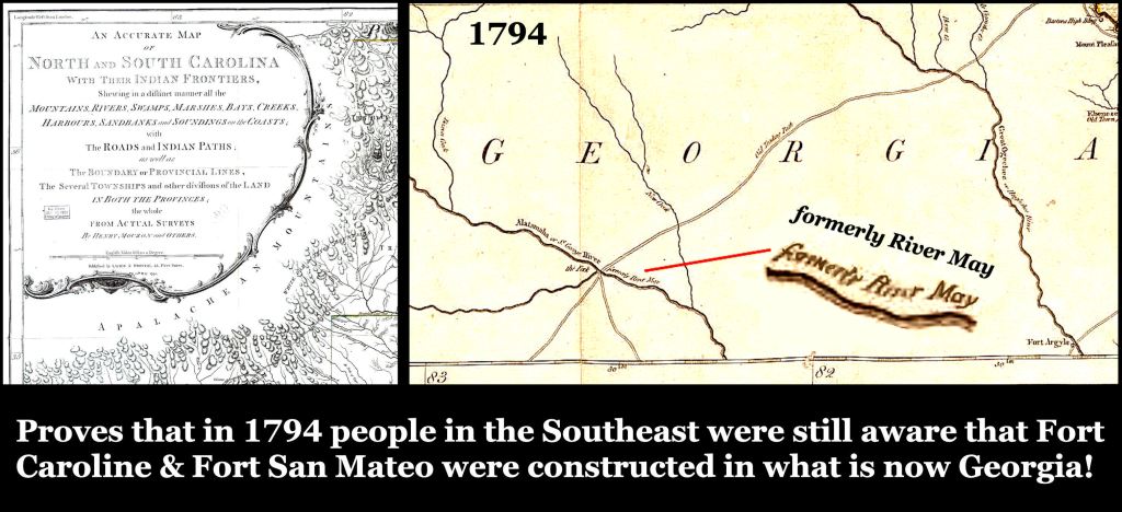
A 1794 map of the southern states, clearly proves that Fort Caroline was in Georgia
- The archaeological reports cited several indigenous words and political titles from the South Atlantic Coast, which they labeled “Creek.” I could not find any of these words in Muscogee-Creek, Seminole, Koasate, Chickasaw or Alabama dictionaries.
- The archaeological reports, plus memoirs of French and Spanish explorers described polytheistic religions that among some tribes involved human sacrifice. At this time, the proto-Creek peoples in Georgia were monotheistic . . . worshiping an invisible Sun Goddess, quite similar in concept to the YHWH of the ancient Hebrews. Both human and animal sacrifice were forbidden in Creek religion.

The convento at Santa Catalina had three rooms, three doors and a front portico like the homes of leaders in district administrative towns in southern Mexico. If these towns grew into small cities, the governmental centers often were stone masonry, super-sized versions of the original thatch-roofed houses. The archaeologists at AMNH had no explanation why the Georgia coastal villages continued this tradition.
- Tabby architecture originated with the Native peoples on the Georgia Coast. It was not developed by Spanish colonists. In fact, the word “tabby” may have evolved from the original name of Tybee Island, GA . . . Taube. Tabby walls were a primitive form of concrete, created by mixing crush sea shells, hydrated lime, sand and white Kaolin clay together.
- All French and Spanish reports placed the provincial capital of Chicora about 16 miles upstream on the Savannah River. The location is now Downtown Savannah, GA. Meanwhile, South Carolina academicians, sometime in the late 1800s or 1900s,placed Chicora near Georgetown, SC . . . north of Charleston. The official historical texts on the original locations of Native American tribes in South Carolina are skewed by this mistake.
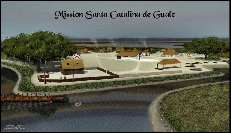
In its last phase, Mission Santa Catalina de Guale was protected by a small fort, garrisoned by a company of Spanish soldiers, assisted by a militia of mission Indians, armed with Spanish weapons. By then, the mission system had been decimated by pirates and slave raiders.
Fake history is not our concern!
My assignment by the American Museum of Natural History was to create accurate architectural drawings of the mission and Native Americans on Santa Catalina Island. However, I did express my concerns about the many contradictions between the eyewitness accounts in the two boxes they sent me and what was in textbooks.
The AMNH staff told me not to be concerned with the fake history. My role was merely to produce accurate 3D drawings of the buildings unearthed by their archaeological team. Perhaps, because they lived in New York City, they really didn’t give a flip about the fake history associated with the region around the mission.
At the time, I was still primarily an architect-planner involved with the design of new buildings and the restoration of old ones. The falsification of this particular aspect of North America’s history really bothered me, though. I had found repeated examples where prominent Florida professors and authors of published books and university-sponsored websites had changed the latitudes on French and Spanish archival documents to match the state’s fake colonial history.
Had travesties like this situation gone on elsewhere in the United States, Canada and Mexico? It would take me many years of research to unravel the profound role of immigrants from the Caribbean Basin and South America in shaping the indigenous cultures of the Southeast and Midwest.
For example, the founders of the Hopewell Culture first lived in the Florida Panhandle before becoming firmly established in present-day Ohio. They most likely originated in the Amazon Rain Forest.
The Truth is out there somewhere!

Thanks Richard Thornton!
LikeLiked by 1 person