
National Native American Heritage Month
A Carib tribe formerly was located on the coast of Georgia in present-day Liberty County, near the historic town of Midway and still living in the Orinoco River Basin of Venezuela
The name means “Toucan Tribe” in the dialect of Carib spoken in the Orinoco River Basin. The Tacatacoro led a coalition of tribes that along with a small private army from France, first massacred all four forts constructed in the hinterlands during 1567 by Captain Juan Pardo . . . then in early April 1568, massacred three larger Spanish forts built at the mouth of the Altamaha River in present-day Georgia.
The Many Peoples of the South Atlantic Coast Series
by Richard L. Thornton – Architect & City Planner

Massacre of Fort San Mateo on the Altamaha River in Georgia
Despite what you are told by Wikipedia, National Park Service literature and a legion of books, published by Florida academicians, Tacatacoro was NEVER located on Cumberland Island, GA and no map places a village, named Tacatacoro, there.
Apparently, those in this tribe, who survived a war with the Spanish Empire and waves of European diseases, eventually moved inland and joined the Creek Confederacy.

Probable appearance of Tacatacoro around 1565 AD
Carib architecture
This is the style of Carib Architecture, constructed in the Oronoco Basin, Trinidad and the Lesser Antilles. However, I assumed that the Caribs, like other tropical transplants on the Georgia Coast, adopted the wattle and daub walls of Inland peoples, to better survive winter temperatures. It does sometimes drop below freezing on the South Carolina and Georgia Coasts.
Both French and Spanish eyewitnesses stated that many, if not most of the tribes on the Atlantic Coast between Charleston Bay, SC and St., Marys Sound, GA constructed massive A-frame combination apartment buildings-council houses that are still constructed in the Amazon Basin today. Back then, the structures varied in size from about 50 to 500 occupants.
Both French and Spanish eyewitnesses also stated that the peoples on the Georgia Coast stuccoed their buildings with a mixture of crushed sea shells, white kaolin clay, hydrated lime and white sand. They said that these buildings “glistened like pearls.” This is the origin of “Tabby” Architecture. The Spanish applied Native American technology to the construction of their own buildings. They did not introduce Tabby Architecture to the region.
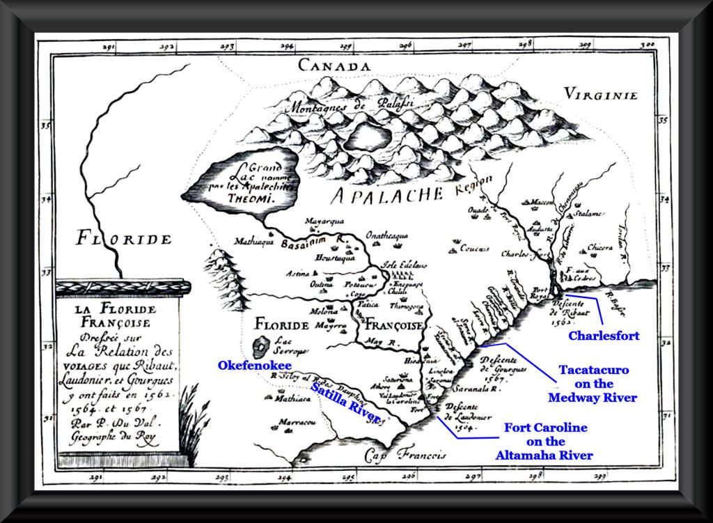
Map showing the three French forts by France’s Royal Geographer – Pierre du Val
Why don’t Southeastern archaeologists know how to read maps and dictionaries?
In my upcoming book on the South Atlantic Coast, readers will get the full story of how a chain of amateur historians, professors, professional archaeologists and government bureaucrats in Florida royally screwed up the Native American history of the Georgia Coast and northern Florida. However, below is the essence of what happened. It would have never happened, if someone in Florida or Georgia in the past 186 years had looked at Colonial Period maps, original eyewitness accounts or more recently . . . Native American dictionaries!
Phase One – Shortly after graduating from college in New York with a Liberal Arts degree in 1838, George S. Fairbanks moved to St. Augustine, Florida with his bride.
Phase Two – The transplanted New Yorker began buying up large tracts of land near St. Augustine and the village of St. Augustine, while serving as Clerk of Court.
Phase Three – Fairbanks began mass-distributing brochures throughout Northern States, which promoted sales of his lands. It was in these brochures that he created the myths of the Fountain of Youth being in St. Augustine and Fort Caroline being in Jacksonville.
Phase Four – These brochures grew by 1858 into the first Florida History book. This was just in time to the new channel created by the US Army Corps of Engineers to allow ocean-going vessels to enter the St. Johns River. The interesting thing is that in 1858, the entrance to the St. Johns River from the Atlantic was only seven feet deep and about 50 feet wide. A trans-Atlantic merchant ship in that era had a draft of from 16 to 24 feet below water!
In 1565, the depth of the narrow entrance to the St. Johns River at high tide was about 6 feet and low tide about one foot or less. The galleons utilized by the Spanish to conquer Fort Caroline had drafts of from 10 to 20 feet. The French fleet had drafts of 8 to 16 feet. Until the early 20th century, the official location of Fort Caroline in Jacksonville was separated from the St. Johns River by about two miles of tidal marshes. It was absolutely impossible for Fort Caroline to have been constructed on the St. Johns River.
In 1861, Fairbanks became a bonified Confederate officer . . . making him forever accepted amongst local Southerners. The man became extremely wealthy after the Civil War from real estate sales in Jacksonville.
Phase Five – In 1881, the now-bonified Southerner, Fairbanks published the first official History of Florida textbook . . . which of course, placed Fort Caroline in Jacksonville and the original location of St. Augustine in Florida. Several generations of Floridians learned their history from this book or later updates.
Phase Six – From then on, a chain of authors and archaeologists began quoting this history book for facts on early Florida and Georgia, rather than checking historical maps or colonial archives.
Phase Seven – Florida archaeologist Jerald T. Milanich was hired by the National Park Service to study a Native American village site at Dungeness on Cumberland Island. He (admittedly) speculated that this village was Tacatacuro – labeling it a Timucua village, since he was from Florida. He could have easily translated Takatacuro with a Carib dictionary. Didn’t matter . . . all French and Spanish maps labeled the village as being Anacura. French maps said that the Saracora (Damp Ground Tribe) occupied St. Marys Sound. Spanish maps called these people the Sorrocha . . . NOT Timucuans . . . NOT Mocamas.
Phase Eight – In 1977, Louis Torres in the Denver, Colorado Regional Office of the National Park Service was assigned the task of writing the official history of Cumberland Island National Seashore. He quoted Milanich as stating as a fact that Tacatacoro was on Cumberland Island and a Timucuan tribe. He then cited a 1932 book by a historian in St. Augustine, which misinterpreted a report by Spanish army officer, Antonio La Prada, after the massacre of Fort San Mateo. La Prada stated: “
“Takatacuro está a 20 leguas al norte de la ubicación original del Fuerte San Agustín.”
(Takatacuro is 20 leagues [46 miles] north of the original location of Fort St. Augustine.)
The capital town of the Carib-speaking Takatacuro tribe was indeed, exactly 46 miles north of the original location of St. Augustine in southern Glynn County, Georgia. The Native American village excavated by Jerald Milanich was 35 miles north of the final location of St. Augustine . . . but unfortunately, Florida tourists never seem to get directions or read maps when traveling in Georgia. LOL
Now you know!

A grammatical editor would be very beneficial for your stories. Sent from my iPhone
LikeLike
Actually, WordPress does have a grammatical editor. So, where did the computer and I make an unforgivable grammatical mistake?
LikeLike
not unforgivable. AI is not very good
LikeLike