Sixteenth and seventeenth century eyewitness accounts, historic maps, plus linguistic and cultural traits, suggest that the “Earth Lodge” Tribes of the Western Plains began as colonists from the Amazon Basin on the coasts of South Carolina and Georgia,
The Quapaw definitely remember originally living near the mouths of the Santee and Pee Dee Rivers in South Carolina, when the first European explorers arrived.
The Kansa were still living in Georgia when De Soto came through and until after the American Revolution. The Cherokees took their mother town in NW Georgia and redeveloped it into New Echota.
Recently discovered eyewitness accounts and maps place the Oto on St. Catherines Island and nearby on the mainland in villages with Panoan (Peruvian) names. The Oto occupied a large village near Warner Robins, GA until around 1805 AD.
The Many Peoples of the South Atlantic Coast series
Richard L. Thornton, Architect & City Planner
Etymology
Guale (Spanish) Ouale/Oueda (French) Wallie (English)
Uehawle/Uete/Uetaw/ Wahale/Wahasi (Creek)
Meaning = Sea People or South Sea People Original Ethnicity: Campeche Chontal Maya
Modern Place Names: Euharlee, GA, Euhaw, SC , Euhaw, AL, Euhaw Springs, SC, Wahatchee Creek, GA, Gullah Language
As mentioned in several previous articles, the American Museum of Natural History sent me two boxes of archaeological reports and photo-copied Spanish Colonial archives in 2007, prior to creating CADD drawings of Mission Santa Catalina de Guale on St. Catherines Island, plus some Native American architecture. I eventually had to return most of the material, except archaeological reports, published directly by the AMNH.
The American Museum of Natural History was the new name for the Heye Museum, which was founded by industrialist-self-styled archaeologist George G. Heye. Heye is the man, who excavated the Nacoochee Mound, near where I live, then carted all the artifacts back to New York City. The AMNH is now owned and operated by the Smithsonian Institute.
The orthodoxy taught me by the AMNH archaeologists was:
- No one knew the Native American name of St. Catherines Island.
- There was one village on the island, occupied by the Guale. They were “Eastern Creeks,” who had moved down from near Savannah around 1500 AD and now occupied the region from the Altamaha River northward to the Medway River (southern end of Ossabaw Island).
- Archaeologists pronounce Guale as Goo-aw-lee. Because of the fellowship in Mexico, I knew however, that those letters were pronounced like “Wally.”
- The Eastern Creek language is now extinct, so one word can now be translated – mekko – the word for a chief. (Mekko turned out to be a Chontal Maya word)
The Real History
I first became aware that Fort Caroline was on the south bank of the Altamaha River in Georgia, when reading the Spanish Colonial Archives. The other Guale words sure didn’t look like Muskogee words, but I had to make a living. I really didn’t give much thought to “Guale Thing” until beginning serious research on the South Atlantic Coast with a powerful HP AI computer last year.
The South Carolina Archives were very useful. Early Carolina maps showed a large tribe, living immediately south of Savannah, that the British called the “Wallie.” That’s the same phonetics as Spanish Guale. The French generally called them Ouade (Wah-dee). The Creeks called them Wahate, Wahali or Wahasi. A Creek T is pronounced more like a French D. So, all those names were for the same tribe.
South Carolina authors stated that the Wallie spoke a very similar language to that of the Yamasee. They were close allies of the Yamasee and paid dearly for it in the Yamassee War (1715-1717) Most Wallie were either killed in that war or sold into slavery. The few survivors became allies of the Creeks and soon spoke the Itsate Creek language.
Wading through 20th century Florida mythology
It takes quite a awhile to connect the lines between the dots in the Early Colonial Period in the Lower Southeast, because while Florida academicians were going to extreme effort to conceal the fact that Fort Carolne was not even in Florida, Georgia academicians typically ignored the 16th and 17th centuries, because someone somewhere told them that there was no information available.
Back in the late 20th century, the University of Florida, Florida State University and the University of North Florida produced grossly inaccurate maps, which moved all the tribes on the Georgia Coast southward about 80 miles. Thus, tribes near Darien, GA were placed near St. Augustine, FL and a generation of masters level anthropology students in Florida have written term papers on why no Indians lived on the coast of Georgia between the Altamaha River and the Savannah River. Thus, when you google the Native American town of Seloy or look it up in Wikipedia, you are told that it was a Timucua town on St. Augustine, which mysteriously disappeared soon after the Spanish colony was founded.
Sounds simple enough? Well, no! You see, the same academicians, put the Spanish missions in the right places. Until the 1570s, most of the missions were in Georgia, because that’s where the corn and beans grew – and the Indians knew how to grow it – in order to feed the lazy bellies of St. Augustine. The academicians fixed that by making two tribes with the same name, one in the right location, being parasitized by a mission and the other somewhere in Florida. I never know if the Florida tribe is real or not . . . unless I do a whole lot of fact-checking.
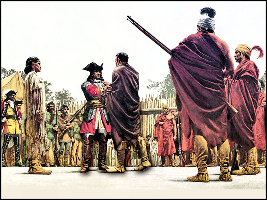
Mary Musgrove (Kusaponakeesa) translates the words of Chikili as he and Oglethorpe meet.
[Savannah, Province of Georgia ~ June 6, 1735]
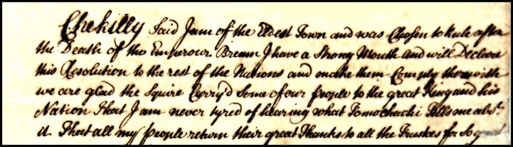
Remember in April 2015, when I found the original manuscripts of the Creek Migration Legend in Lambeth Palace in London? Then, Prince Charles paid for very expensive archival photographs to be given to the Georgia Historical Society in Savannah and the Muskogee Creek Nation in Oklahoma. The professional historians refused their copy three times because “It couldn’t exist. It has been lost for 280 years.”
Maintaining the standards of their Georgia Historical Society counterparts, bonified PhDs in the Muskogee Creek Nation’s Archives Committee refused their copy because (1) The original manuscripts no longer existed (2) They had never heard of Mary Musgrove, who translated High King Chikili’s speech into English. They asked, “Who is she?” (3) Mary Musgrove’s translation was all wrong. (4) They were tired of white people like this Mary Musgrove woman, trying to change Creek History!
The Good News is that the National Park Service graciously accepted their photos. They are on display at Ocmulgee National Historical Park.
In this past autumn’s endeavor, I was trying to figure out why Florida-authored books, the National Park Service and Wikipedia stated that the Takatakura was a Timucuan village on Cumberland Island and the Native American name of the island. All historic maps show two Tacatacuras. They were a Carib tribe about 30 miles south of present-day Savannah and a still-existing Carib tribe in southern Venezuela. Takatacuro means “Toucan People or Tribe.”
I then found a very interesting, 47-year-old professional paper from the Department of Anthropology at the University of Florida. Once section described the voyage of Captain Dominique de Gourgues in the autumn of 1568. Gorgues funded and commanded the small fleet of French volunteers and Georgia coastal Indians, who massacred Fort San Mateo and two smaller forts.
The professor stated that Dominique de Gourguesa sailed past the broad channel of the May River, which was flanked by two large islands without being spotted by the Spanish. His fleet then sailed the length of the first island to the north and then the next, much larger island. The French then decided to turn left into a large estuary, which turned out to be the mouth of a river, which was at about 31° 40’ Latitude. They sailed up the river to a bend, which could not be seen from the ocean. Here they built a fort.
De Goursgues made friendly contacts with local Indian villages. It was clear that these people had experienced many outrages from the Spanish, but like the French Huguenots, who visited them. Soon, De Gourgues met with the leader of a large town within the interior of the peninsula to the south, named Takatacouou in French. These Caribs were fierce warriors and became the leaders of a Native American alliance, which wiped out three forts in early April 1569.
The Florida academician chose to ignore De Gourgues’ statement that he sailed past two islands and also the latitude of estuary, where the fleet turned westward. Instead, he stated that De Gourgues established a fort on the St. Marys River, where the town by that name sits today. The author placed Takatacuro on the opposite bank of the St. Marys River.
Within a few years, Florida authors, for unknown reasons, started showing another Takatacuro on Cumberland Island. Absolutely no French or Spanish map places a town by that name on Cumberland Island, GA. However, go to the National Park Service website or Wikipedia and that is what you will see.
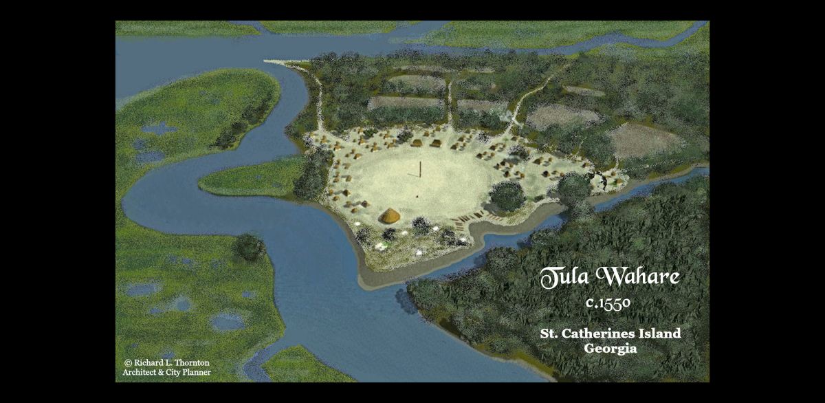
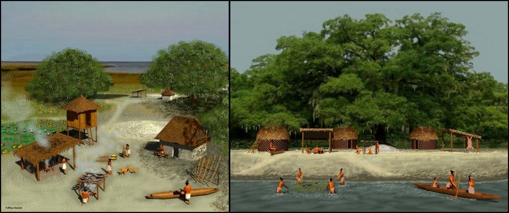
Eventually, my new AI computer was able to access a document in France, which actually listed the French names of the five villages visited by the French on St. Catherines Island. You will notice that they represent three different ethnicities . . . Panoan from Peru, Chontal Maya from Mexico and Itsate Creek from Georgia. Itsate Creek in earlier times was probably just a dialect of Itza Maya.
Villages on St. Catherines Island
*Pará is still the name of the Brazilian state that covers most of the northern Amazon Basin.
Culapala FR < Kurapará – (Panoan name for St. Catherines Island.) – Means “Tribe from Upper Amazon Basin” It was probably also the name of the principal town on the island before around 1500 AD.
Otapala SP = Otapará – Panoan word meaning “A small sweet squash that is indigenous to the Amazon Basin” – NA name of Blackbeard Island, which is attached to St. Catherines Island.
Otaxe SP < Otashe = A satellite village of Otapará on St. Catherines Island, showing a Creek grammatical suffix.
Posache SP = “Little Grandmother” in Itsate Creek on St. Catherines Island
Walie/Wahale EN < Ouale/Ouade FR < Guale SP = “Ocean People” or “Southern Ocean People” in Campeche Chontal Maya on Cumberland Island.
Readers can see in this brief discussion of St. Catherines Island that the Pre-Columbian history of the South Atlantic Coast was significantly more complex than the archaeology profession has assumed for the past 130 years. The region was populated by numerous, distinct ethnic groups, who probably arrived in relatively small numbers.
Most of the visible burial mounds on the coast of Georgia were destroyed by a grave robber-art collector in the last three years of the 19th century. Most of Savannah’s earthen burial mounds were destroyed during the 1930s by significantly more professional WPA-funded archaeologists. This has caused archaeologists to show little interest in the region during the past 75 years.
From the very beginning the primary targets of pseudo-archaeological and archaeological expeditions . . . with the exception of the AMNH dig at Mission Santa Catalina de Guale . . . were mounds. Yet, most of the tribes that colonized the region were not mound-builders. The Wahale were not building mounds at the time of their move to St. Catherines Island. The Panoans, Taino, Caribs, Peruvian Arwaks and Tupi-Guarani did not build mounds, but in their homelands, they were known for their skills in ceramics and the making of gold jewelry. Perhaps, all along the trophy artifacts were in village sites with no mounds.

The small, fruit-sweet “Oto” squashes from the headwaters of the Amazon Basin grow well in the Lower Southeast, but are little known outside of families, who immigrated here from Central and South America. They prefer warm, humid growing conditions. Their seeds are typically not available from local retail stores, but can be ordered online.
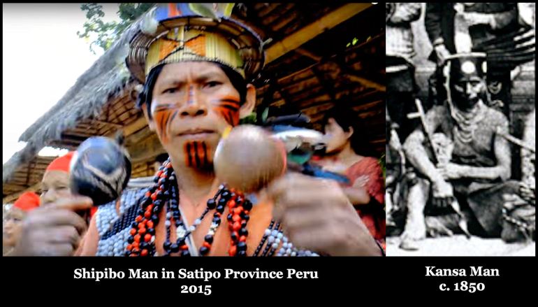
What about the Oto and other earth-lodge peoples?
As can be seen above, 19th century photographs of earth-lodge leaders show many wearing typical Panoan clothing. It is likely that as they migrated northwestward from the Atlantic Coast, they merged with peoples, speaking Siouan languages. By the time that they were on the Great Plains, they were speaking languages with Siouan traits.

Thank you for this intriguing information, and for fighting to set the historical record straight.
LikeLiked by 1 person