Skip to content

The Americas Revealed

Unraveling the past of the Americas, while preserving that past for the future.

  • Home
  • Contact
  • The Americas Revealed

Category: Maps

Happy Ocmulgee New Year’s Day! December 21, 2023December 25, 2023
Climate of Southern Appalachians was very different in the Colonial Period! October 23, 2023October 27, 2023
Indigenous names of islands and rivers along the South Atlantic Coast. October 6, 2023
The Muskogee Creeks originated in the North Carolina Mountains! July 7, 2023July 7, 2023
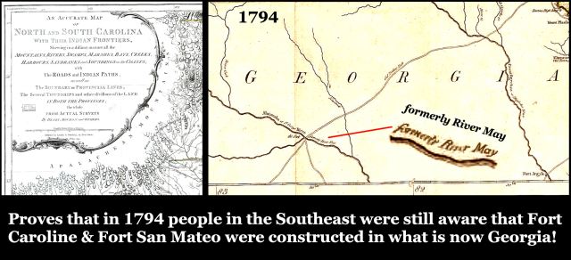
1794 map proves that Fort Caroline was located in present-day Georgia! February 8, 2022February 9, 2022
Evolution of the Nikwasi Mound . . . . Franklin, North Carolina – Part Two December 28, 2021
Chote . . . Chota . . . Echota – How contemporary Cherokees and academicians got it all wrong! October 18, 2021October 19, 2021

Search

Enter your email address to follow this blog and receive notifications of new posts by email.

Join 4,128 other subscribers
Powered by WordPress.com.
  • Subscribe Subscribed
    • The Americas Revealed
    • Join 759 other subscribers
    • Already have a WordPress.com account? Log in now.
    • The Americas Revealed
    • Subscribe Subscribed
    • Sign up
    • Log in
    • Report this content
    • View site in Reader
    • Manage subscriptions
    • Collapse this bar