
Habersham County, Georgia
by Richard L. Thornton, Architect & City Planner
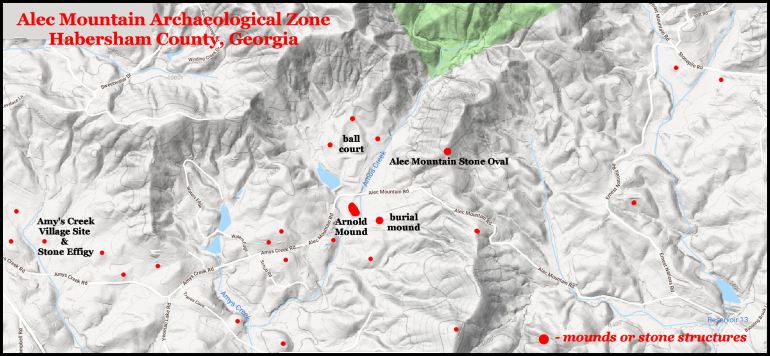
The Alec Mountain Archeological Zone is located about seven miles northwest of Clarkesville, GA in the extreme northeastern part of the state. This Indigenous American occupation zone is contains approximately 660 acres (267 hectares). Key visible prehistoric features include the Alec Mountain Stone Oval, the Arnold Mound, a large burial mound and the Amy’s Creek Stone Enclosure. There are also several dozen earthen mounds, stone mounds, stone cairns and village sites. This zone is certainly eligible for the National Register of Historic Places, but has never been nominated.
Etymology and Historical Background
Alec is the Anglicization of the 18th century Creek Indian word, Alek, which means “medical doctor” or “medicinal herbs.” That word seems to have been borrowed from Alekmanni People of Georgia. (See below) However, their word for medicinal herbs seems to be borrowed from a Bronze Age Southern Scandinavian/Archaic Anglisc word A-laek, which means the same thing. Laek was the Old English word for herbs, which now survives as the word for a cousin of the onion called leeks. The modern Swedish word for a medical doctor is lekare.
The Alek-manni (Medicinal Herbs-Men in Archaic Scandinavian) were a tribe on the Altamaha River in Southeast Georgia near present day Jesup. They were described by Captain René de Laudonnière of Fort Caroline as growing valuable medicinal herbs, especially cinchona trees for making quinine. He said that their name meant “Medicine People.” It is possible that the Alec Mountain villages composed an Alekmanni horticultural colony for cultivating highland herbs.
During the 18th century the site of the Alekmanni capital on the Altamaha River was occupied by a Creek Indian village, known as Alektown, but the community now is known as Doctortown. It was the scene of a tragic accident in 2014, when a trespassing movie film crew was struck by a CSX freight train.
Natural Features
The Alec Mountain Archaeological Zone is characterized by rugged mountain terrain, interspersed by narrow stream floodplains. The rocks here are volcanic . . . most stone is rhyolite, dacite and pumice. The archaeological zone is within the boundaries of an ancient volcanic caldera, which included all of the Soque River, Upper Maudin Mill Creek and Sautee Creek Basins.
Amy’s Creek flows off the slopes of Irwin Mountain then generally southeastward for about 4 miles before joining the Chattahoochee River. Amos Creek flows off the western slopes of Alec Mountain then flows generally southward to join Amy’s Creek. The flood plains of these creeks are quite narrow. It would seem that they were inadequate in area to support a large sedentary population.
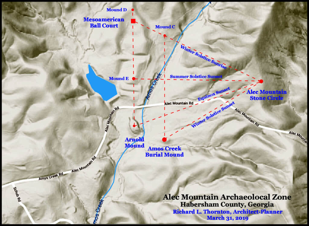
Site Plan and Alignment
There are precise geometric relationships between all the major man-made features in this archaeological zone. These are all associated with the seasonal changes in the location of the sun in the sky. It is clear that at least one of the functions of the Alec Mountain Stone Oval was to monitor the seasonal and daily position of the sun. There is approximately 400 feet (122m) difference in elevation between the Stone Oval and the Arnold Mound. This suggests that the people living in this region were skilled land surveyors and had knowledge of trigonometry.
1 – Alec Mountain Stone Oval
34°39’44.9″N 83°36’02.2″W

The Alec Mountain Stone Oval is an extremely important archaeological site in Georgia that is practically unknown to both the general public and the current generation of archaeologists in Georgia. It originally consisted of a stone wall at least six feet (2 m) high with a long axis of about 103 feet (31.4 m) and transverse axis of about 89 feet (25 m). The oval is built on about a 10% natural slope and possibly contained terraces inside the wall. It is aligned north-south with a gap in the wall aligned to the azimuth of the Winter Solstice Sunset. There was a stone altar on the northern end of the ellipse, whose original form is now indiscernible because over the past two centuries, people have taken stones from the structure to build chimneys and fireplaces in their homes.

A traveler named Charles Lanman mentioned the ruins in the book, Letters From the Alleghany Mountains, published in 1843. He stated that neither local residents nor the previous American Indians in the area could explain the ruins. The Stone Oval was publicized in writing by Smithsonian Institute archaeologist, Cyrus Thomas, in 1891 after being visited in 1886. Thomas interpreted the structure as being constructed by a “tribe of civilized Indians,” whose identity has been forgotten. WPA archaeologist, Robert Wauchope, visited the site in 1939, while surveying the Nacoochee Valley. He also interpreted it as probably being American Indian in origin.
In 1956, Harvard anthropology professor, Phillip E. Smith excavated transverse ditches across the oval, but found no artifacts. Those trenches are still visible after 63 years! He did not dig any test pits outside the oval or become acquainted with other structures near Alec Mountain. However, he did produce a measured drawing of the structure. The Apalache Research Foundation team used more accurate measuring devices and found the structure to be slightly smaller than he labeled his drawing. We also discovered that the slot in the Stone Oval was perfectly aligned with the center of the Arnold Mound in the valley below . . . in addition to being aligned with the Winter Solstice Sunset.
At the time, that Phillip Smith studied the Alec Mountain Stone Oval, it was being maintained by a Boy Scout troop. The site improvements included a parking lot next to the the old right-of-way of Amy’s Creek Road. During the mid-20th century the ruins were a major tourist attraction for the region. However, when the right-of-way of Amy’s Creek Road was changed by the county roads department, a new parking lot was not constructed. As a result, within a generation most residents of Habersham County had forgotten that the ruins even existed. Even young adult residents of the Amy’s Creek Community are unaware of this important archaeological site’s existence.
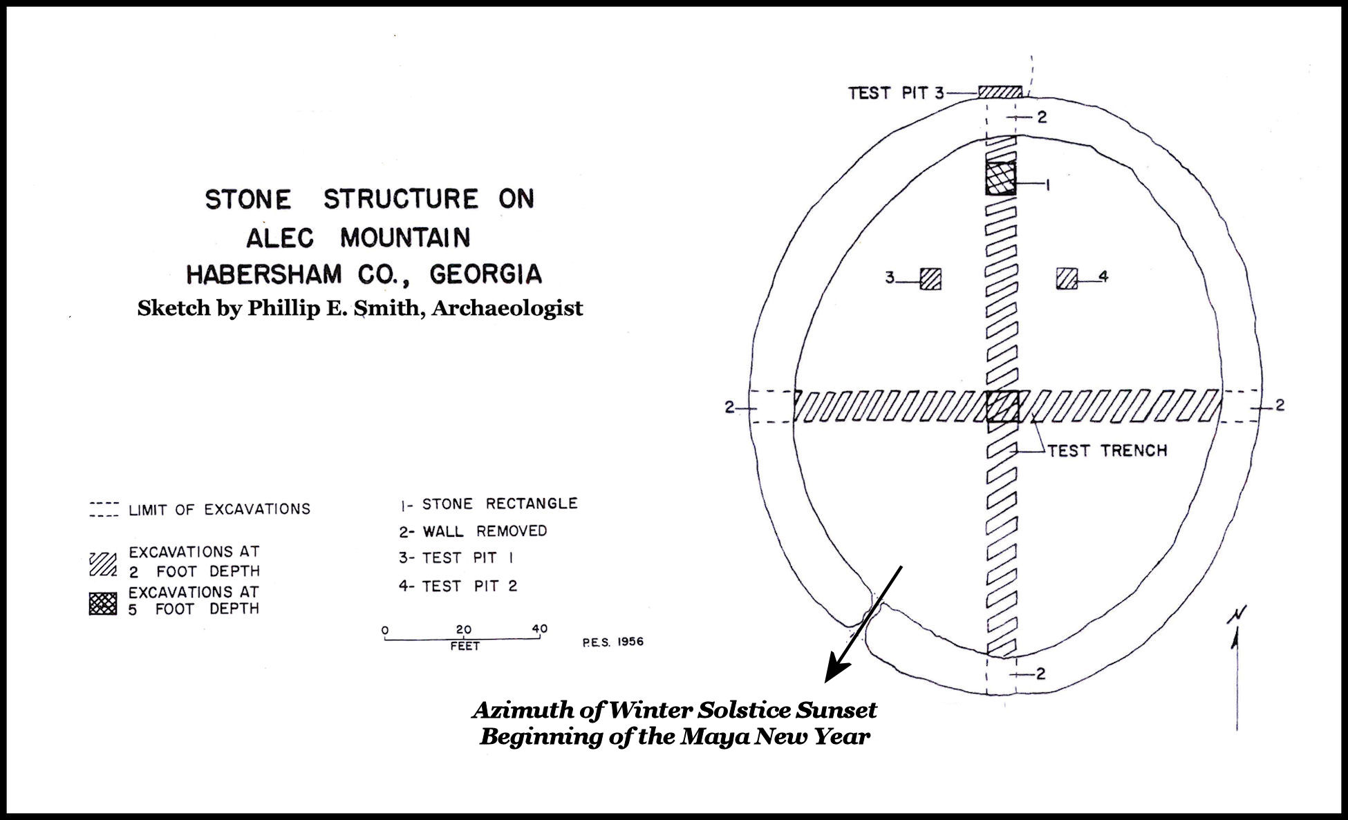

Because leaves have piled up over the stone ruins, it is very difficult to photograph the site.

2- Arnold Mound
34°39’37.1″N 83°36’29.5″W
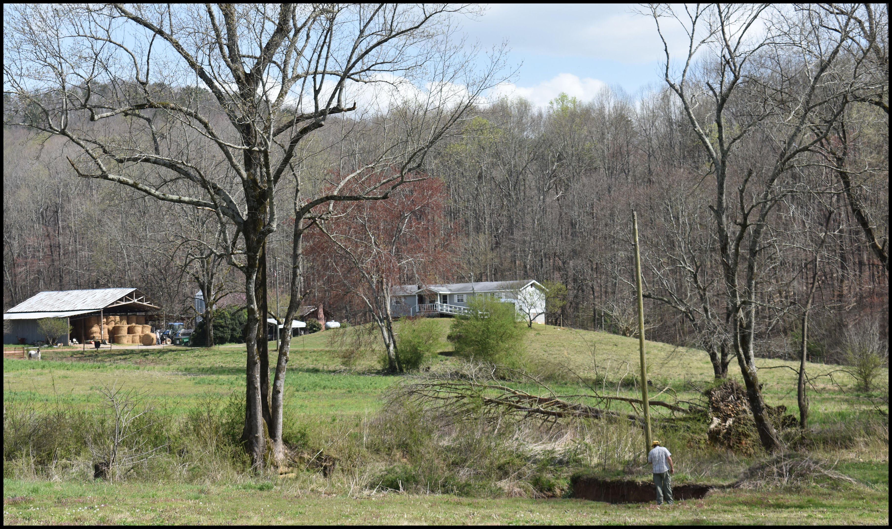
The Arnold Mound is named after the Arnold Family, which has owned the property for many years. George Locke Arnold always suspected it to be a mound, but could not get state archaeologists to look at the site. As a result, in the late 20th century the Habersham County Road Department excavated about 15 feet off the top of the mound to use as fill soil for the re-construction of Amy’s Creek Road. The surviving mound is still up to 25 feet tall. The fact that the mound is aligned with the Alec Mountain Stone Oval leaves little doubt of its man-made construction. About 150 feet downstream from the mound is a small island in the creek, where there is a boulder with a human figure carved on it.

The Arnold Mound is located on the south side of Amy’s Creek Road at the confluence of Amos Creek and an un-named brook. It is oval in shape. Its long axis is 315 feet (96 m), while its short axis is 165 feet (50 m). Since being partially excavated and the base grade varies, the height of the mound varies between 25 feet and 16 feet on its northwestern end. The original height of the mound was probably about 40 feet.

The siting of this mound is quite unusual for the United States. Typically, mounds of this scale were located in broad riverine flood plains and associated with large towns. This mound was placed in the center of a shallow pond, created by a small creek in a minuscule flood plain. The only other mound in the Southeast, which was constructed in a body of water was the Bilbo Mound in Savannah, which was radiocarbon-dated by archaeologist William G. Haag to 3545 BC! However, the Bilbo Mound was also connected to the Savannah River via a man-made canal.
Did the Arnold Mound also function as a fortification? That is a possibility. Apparently, the people of this valley lived in dispersed hamlets and farmsteads. The large earthen structure with an “industrial-size” moat could have functioned as a save haven in case of enemy attacks.
There are some large and medium size rocks on the southern end of the mound top. They may have been dragged up the mound ramp, but more likely represent stones of the original grade. This interpretation is not known for certain, but appears that the mound was created by scooping out soil from around the mound and piling it on an existing rise in the natural terrain.
The oval mounds of Georgia, such as this one, probably seem strange to those travelers in the remainder of the USA, who are accustomed to dome-shaped burial mounds and rectangular pyramidal mounds for ceremonial or domiciliary functions. However, they have a long tradition in Georgia, associated with the peoples, who joined together to form the Creek Confederacy. As early as 2200 BC, oval shaped mounds were being constructed along the Savannah River, southeast of present day Downtown Savannah River. They were the norm during the Woodland Period (1000 BC-900 AD) and reappeared in the Late Mississippian and Early Lamar Period (1375 AD – 1550, 1550 – 1700 AD. They represent an indigenous, home-grown architectural tradition, which remained independent of influence from the remainder of other cultures in the Americas.
3 – Amos Creek Burial Mound
34°39’34.7″N 83°36’22.8″W
This large dome-shaped mound is located 450 feet (137 m) East-SE of the Arnold Mound. It is approximately 150 feet (46 m) in diameter. A house has been constructed on top of it. This mound is not listed on the Georgia Archaeological Site Index and has only been excavated by amateur artifact collectors. Its large size suggests that it was a regional mortuary center for many, many centuries.
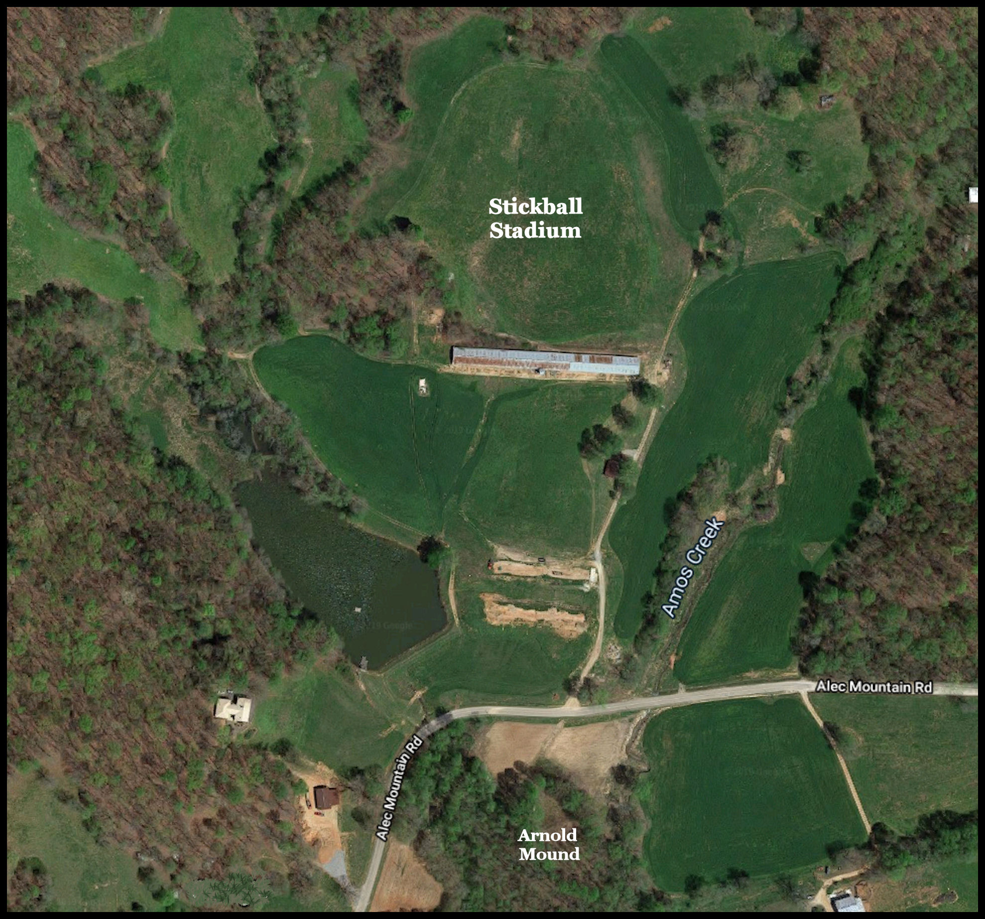
4 – Amos Creek Stickball Stadium
34°39’54.6″N 83°36’30.3″W
There is a tradition among pioneer families in the valley that the Indians played stickball here. This is probably accurate. The field is directly due north of the Arnold Mound. The field is flat and surrounded on three sides by banks that are the perfect slope for seating sports fans. At the northern end of the field is a small mound, which aligns perfectly with the center of the Arnold Mound.

5- Amy’s Creek Village Site and Stone Enclosure
34°39’34.6″N 83°38’00.3″W
A low ridge separates the cluster of Native American structures along Amos Creek from a wider expanse of tillable land and a village site, drained by Amy’s Creek. The grade is not absolutely flat, but the sandy volcanic soil is quite fertile. It is being cultivated nowadays by a vegetable farmer, who markets his produce at farm store on Hwy. 17. The “sand” in this soil is actually volcanic ash.
Local residents have found a wide range of pottery styles, while cultivating the land along Amy’s Creek. The location was always occupied during the period, between around 1000 BC and 1700 AD, but population densities fluctuated. The preponderance of styles during the Archaic, Middle Woodland and Late Mississippian Periods (Deptford, Cartersville Check Stamp and Swift Creek) suggest that it was between 800 BC and 600 AD, plus between 1350 AD and 1700 AD that this region was most densely populated. Early and Middle Mississippian village sites are concentrated around Sautee, about three miles to the northwest. The Creek name for Sautee was Itsate, which means Itza People. The original village of Sautee was 3.5 miles due north of the Amy’s Creek village sites. The newest Native American pottery is polished blackware, which was typical of the Soque in Georgia and Zoque in Mexico. The potsherds are densest in a triangle, immediately east of the stone structure.

An unusual earthwork, veneered with field stones is clearly visible immediately west of the area where potsherds are densest. It is an effigy of “something” . . . most likely the ceremonial mace carried by the ruling elite in Proto-Creek towns. No investigative work has been carried out by a professional archaeologist at this village site. Therefore, more detailed information about its chronology and site plan is unavailable.
About 200 feet southeast of the stone veneered earthwork is a stone veneered mound about 25 feet in diameter. North of it is a smaller earthen mound . . . probably a burial mound. Also visible on satellite imagery are several dark circles, which may be either plowed over mounds or former structures. Without on-site archaeological investigation, this cannot be determined from visual examination.

Each of the major architecture sites and archaeological zones in the Soque River – Sautee Creek – Maudin Mill Creek Study Area will have a detail article on it,
LikeLike
This is profound stuff Richard. Integrated with what I am finding in Union County you would think the Anthropology departments of major universities would be interested! But lets not let their ignorance of this vast set of knowledge be an obstacle to advancing your readers knowledge. Amateur explorers have always been at the forefront of great discoveries and the break up of intellectual stronghold on public perception. With strong evidence you are exposing major flaws in their version of the past. If we are to understand the future we must know the truth of our ancestors. Talk with you soon. Remember Lidar does not lie.
LikeLiked by 1 person
Hey! I am not an amateur! I am a historic-prehistoric preservation Architect. I just don’t disturb the sites. Many of the sites have already excavated some by Robert Wauchope . . . who was very an extremely competent archaeologist.
LikeLike
No you are not! I however, am! LOL.
LikeLiked by 1 person