Chattahoochee National Forest
Union County, Georgia
34°52’57.1″N 83°52’39.8″W
by Richard L. Thornton, Architect and City Planner
Georgia Institute of Technology ~ Georgia State University
Almost five decades ago, workers rebuilding Track Rock Gap Road ran a brisk business selling premium-quality artifacts and skeletons to collectors from the Atlanta Area and other major metropolitan areas. Five hundred years ago, this road was a key link of the Great White Path that connected the Great Smoky Mountains to the Gulf of Mexico. It is now US Highway 129.
This section of the Great White Path apparently was a New World equivalent of the Appian Way. It was lined on both sides by burial tombs and graves. Apparently, archaeologists never learned about this archaeological zone and the supervisors of the road construction project didn’t care. In fact, foremen took an active role in selling artifacts. It is a dirty little story that you have never been told before.

Public investments to attract tourism
One of the many programs funded and coordinated by the Appalachian Regional Commission during the late 20th century was a series of construction projects that were designed to enhance the economic development of the counties north of the Blue Ridge Mountain Range in North Georgia. These projects typically involved matching federal, state and local funds. They primarily were oriented to improving automobile access and creating tourism destinations.
During the early 1970s, when Jimmy Carter was governor of Georgia, the state Department of Transportation and the United States Forestry Service spent millions of dollars to open up the Brasstown Bald Mountain, Track Rock Gap and Arkaqua Creek Trail area to tourism. A multi-million-dollar visitor’s center and Natural Science museum was constructed on top of Brasstown Bald in addition to a large parking lot and paved access trail.
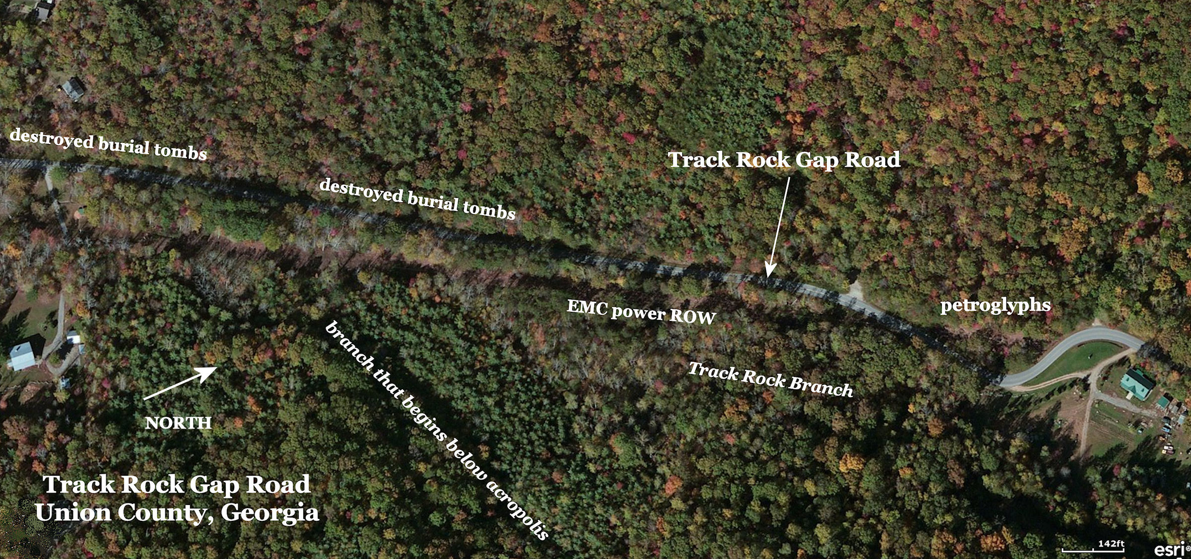
The Georgia Department of Transportation (then the Highway Department) rebuilt Track Rock Gap Road on a new grade. Several ancient stone structures were pushed aside during the construction, but there is much more to the story. In addition, the Blue Ridge Electrical Membership Corporation leveled several stone walls in creating a new right-of-way for a electrical transmission line.
At Track Rock Gap emphasis was placed on six boulders that were covered with petroglyphs. The boulders were gathered together in one location. A small gravel parking lot was constructed to the south of their new location. Originally, the boulders were approximately the same elevation of Track Rock Gap Road. The Georgia DOT intentionally cut the new road bed about 25 feet below the boulders. This was done to decrease the grade of the road and also discourage vandalism.
Strangely, no shelter was initially put over the newly concentrated boulders. The petroglyphs were very legible in 1970, but by the early 21st century, acid rain and fog, caused by a cluster of coal-fired TVA power plants in southeastern Tennessee, has eaten away the patina on the soapstone boulders. Many of the glyphs are barely visible now.
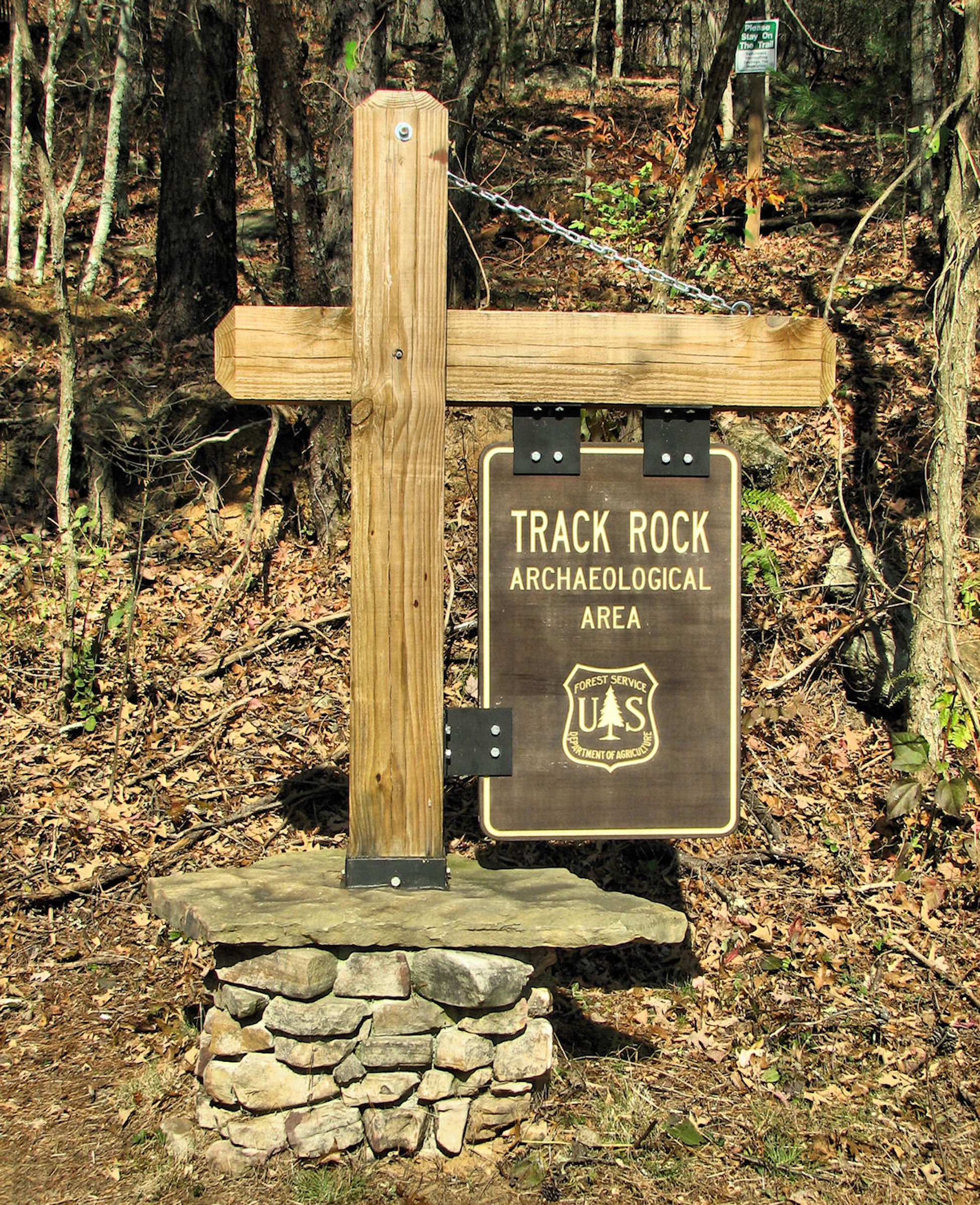
The US Forest Service placed attractive “Track Rock Gap Archaeological Zone” directional signs throughout Union County, GA to guide tourists to the then remote petroglyphs. However, in the 45 years since the reconstruction of Track Rock Gap Road, much of its road frontage has been lined with suburban style subdivisions, farmettes and vacation homes. Track Rock Gap now almost has the appearance of suburbia, not a remote archaeological site. In 2012 the US Forest Service removed most of the signs so that tourists could NOT find the Track Rock Terrace Complex ruins near the petroglyphs.
Track Rock Gap Road was completely reconstructed by the Georgia DOT. Extensive grading was done to meet late 20th century state highway standards. In the process, construction workers encountered hundreds, if not thousands, of indigenous artifacts, plus many human burials. To the east of the road right-of-way, was the site of an ancient Native American village.
The Track Rock Gap Road improvements were funded jointly by several federal agencies, the State of Georgia and Union County. Even then, there were federal laws in place, which required archaeological surveys before federally funded public works projects. Apparently, such a survey was avoided by having archaeologists with the federal and state governments report that the only significant site along the proposed construction route was the section of the Chattahoochee National Forest where the petroglyphs were located. At this time, most archaeologists considered the stone ruins at Track Rock Gap to be product of 19th century farming activities.
Skeletons in the closet . . . skeletons in the ground
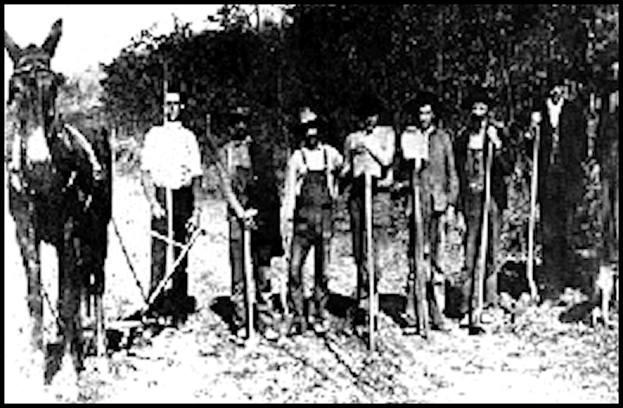
According to interviews with three Union County residents, who as young men worked as laborers on the Track Rock road work, both the construction managers for the private contractor and state DOT were aware of a large quantity of exceptional Native American artifacts, plus skeletons, showing up in the dirt being removed. All those on the project, including the foremen and the supervisors, began taking home artifacts. Then word got out among Atlanta Area collectors about the treasure trove of artifacts that could be had. Throughout much of the construction project, cars from the Atlanta Area would drive up to Union County near the end of each work day. The occupants would then bargain with workers for choice artifacts. Many of the workers made more money from the artifacts and skeletons than they did the construction work.
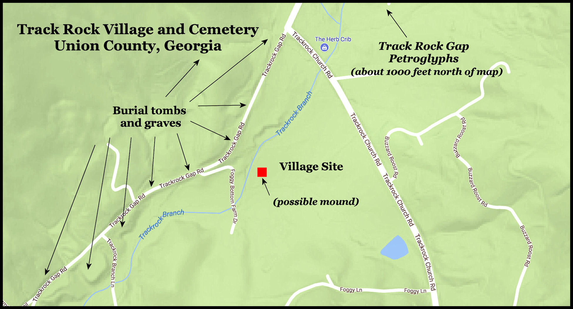
The former road construction workers stated that the choicest artifacts came from man-made tombs on the west side of Track Rock Gap Road. There were also conventional graves on the east side of the road. The workers estimated that there were hundreds of burials, but there was no way to count them since the bulldozers could destroy several in a minute. The artifacts that were sold miraculously avoided destruction by earth moving equipment.
The men stated that the most valuable pottery was “painted and looked like it came from Mexico.” These pieces were primarily in the tombs. There was so much money to be had that the men began going to Track Rock on weekends to dig up tombs and graves in order to obtain perfect artifacts. They didn’t want their names mentioned because they also went onto US Forest Service land on Thunderstruck Mountain with steel rods with which they probed for tombs. This continued for several years until traffic built up on Track Rock Gap Road and made these activities dangerous. Of course, grave digging on federal lands was quite illegal prior to the Native American Graves and Repatriation Act of 1991.
Some men, but not those interviewed, found a village site and a probable mound on the southeast side of Track Rock Gap Road. This land was privately owned. Sometimes they had the permission of property owners. Sometimes it was the property owners themselves and quite often the artifact poachers were trespassing. One of the men interviewed said that “during his lifetime, several tractor trailer loads of Injun things have been dug up and sold out from Union County.” Another one said that he knew were there was an ancient stone quarry with 400-year-old trees growing in it. He also knew of several “caves” (probably man-made tombs) that had “Maya writing” painted on the walls.
The History of Union County, Georgia was published in 1959 by Preston Turner. It also describes “caves with strange Indian paintings” on their walls. The book also states that there are petroglyphs, equally impressive as those at Track Rock on the north end of Thunderstruck Mountain. One of the men, interviewed, stated that he had seen these petroglyphs as a boy, but couldn’t remember exactly where they were. The Track Rock Petroglyphs are on the south tip of the mountain. Local residents claim that there are still hundreds of Native American graves on the south end on lands owned by the US Forest Service or Vulcan Materials, Inc. – a gravel quarry.
Archaeologists have shown little interest in the Southern Appalachians since 1939 . . . except for an intensive flurry of activity in 1990 and 1991, when contractors, widening US Highway 76 north of Young Harris, GA, encountered several village sites near the planned, state-owned, Brasstown Resort. It didn’t hurt that Governor Zell Miller was from Young Harris. It is clear, from the stories told by local residents, that there is much more to the Native American history of the region than one reads today in reference books and history websites.
In Part Three, we will examine a series of archeological studies, funded by the State of Georgia or US Forest Service, between 1989 and 2002.
