
. . . and the Shaw Stone Mound
Bartow County, Georgia
34°09’21.5″N 84°50’12.9″W
It was a remarkable example of indigenous architecture that is virtually unknown among archaeologists in North America outside its immediate environs . . . a complex oval stone structure on a mountaintop overlooking a four-mile long continuous conurbation of Native American towns and villages. In Europe or Latin America, it would have been restored and promoted as a spectacular tourist attraction with a “milion dollar” view. However, in mid-20th century Georgia, it and a stone mound on a terrace beneath it were crushed into gravel to repave a nearby state highway. In the proposed path of this highway were three large mounds, almost 2,000 years old. They were used as fill dirt for the highway.
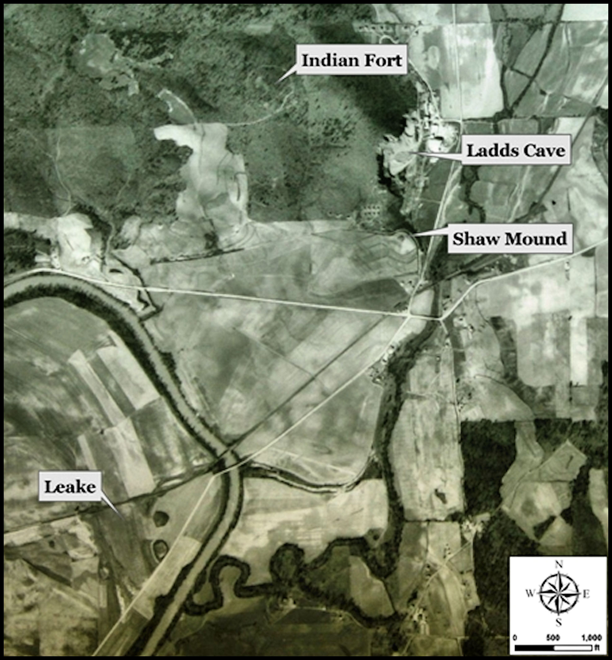

Ladd’s Mountain is named after Alonzo J. Ladd. Ladd bought the Peck Lime Works outside of Cartersville in the early 1870’s. For several decades, it had been mining limestone from the mountains. His company, A. C. Ladd Lime Company, manufactured and traded lime, cement and plaster. An article in the Cartersville American newspaper on August 15, 1884, states that “there is no lime in the South so highly prized as the famous alabaster lime manufactured by A. C. Ladd”.
During the late 19th and early 20th century, several nationally famous archaeologists, such as Cyrus Thomas and Warren K. Moorehead, poked around in the mysterious stone ruins on top of Ladd’s Mountain. They didn’t find any trophy artifacts. In fact, they didn’t even find any potsherds. At least on the surface, the ruins were just stones . . . architecture . . . nothing that one could put on a shelf in a museum or in the parlor of a wealthy donor. In 1883, geologist Charles Whittlesey realized that the ruins were highly significant and focused his energies on an accurate description of the site. That is fortunate, because otherwise, the site would have been largely forgotten by the 21st century.
Charles Whittlesey (born Southington, Connecticut, 10/4/1808; died, Cleveland, Ohio, 10/18/1886) was a professional soldier, geologist and an investigator of Native American mounds in the Eastern United States. He was described by Ephraim George Squier and Edwin Hamilton Davis in their book Ancient Monuments of the Mississippi Valley as a “zealous investigator” in the field of “American antiquarian research.”
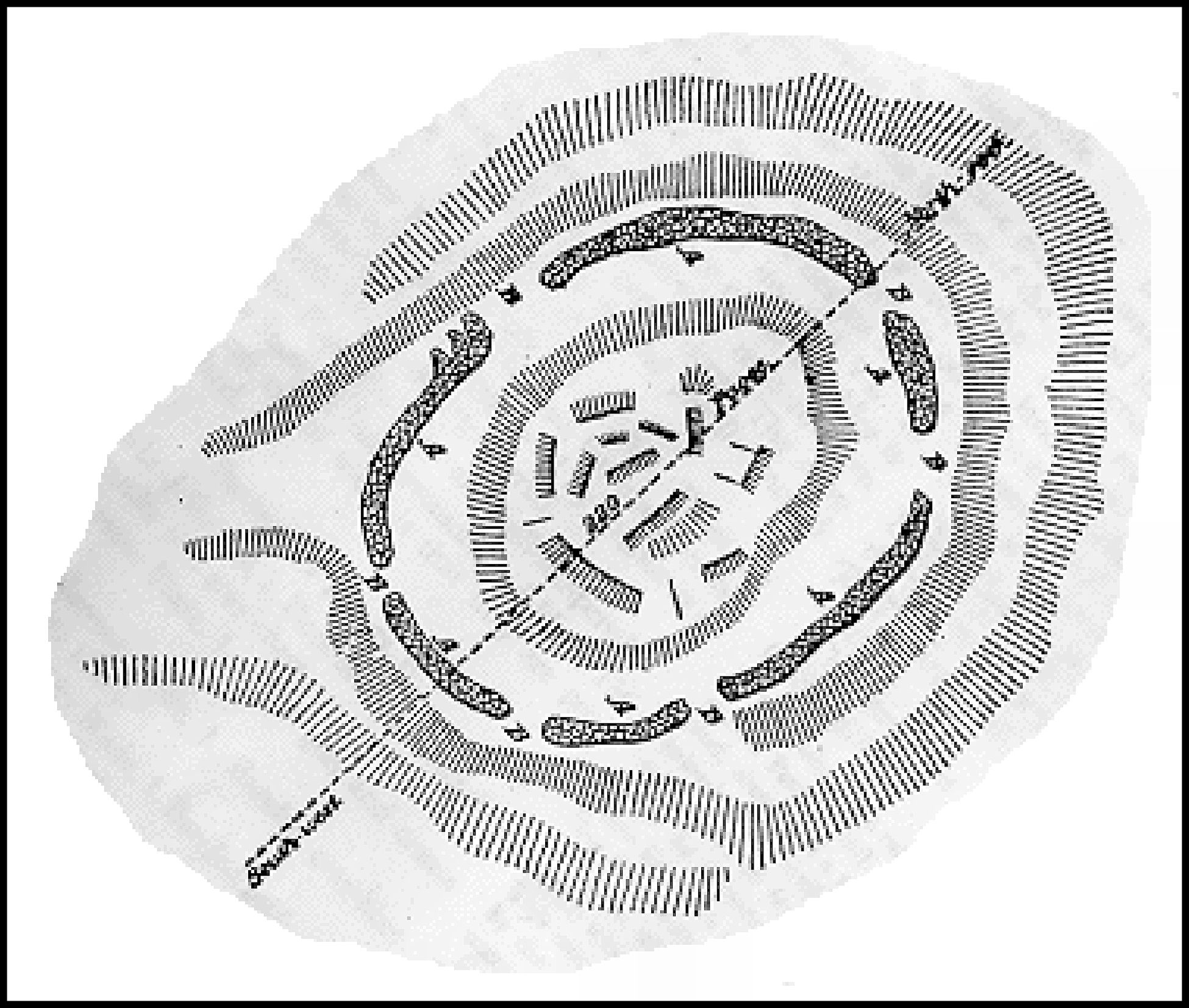
Whittlesey’s description of the “Old Indian Fort” in 1883 was republished in Robert Wauchope’s 1966 book, Archaeological Survey of Northern Georgia: ” . . . It has now the appearance of a heavy stone fence, which has fallen down. There are six openings or entrances, B B B, having a breadth of 10 to 60 inches, situated at irregular distances. It is an irregular oval figure enclosing the rocky summit of the hill, the largest diameter of which is 220 feet and shorter diameter, 200. The elevation of the knob, at the center, is 50 feet above the terrace or bench, on which the lines of the loose stones are lying. The interior space is principally cleared of loose stone, and shows bare ledges of lime rock, in horizontal layers.“
“The hill (Ladds Mountain) is covered with an open growth of oaks. There is nothing in this structure suggestive of a fort, except its elevated position, which, however, is by no means inaccessible. The openings are too numerous to warrant the idea of a defensive work. It is more probable that it was the scene of imposing public processions and displays, and was approached by crowds of persons from all sides of the openings. The rude wall or line of stones would be the necessary result of cleaning the ground of the blocks of limestone once scattered profusely over the surface.”

The mid-20th century generation of archaeologists had become obsessed with potsherds and projectile points. They were trying to develop a chronology of the nation’s pre-European past. Stacks of stones didn’t seem very productive locations for developing a chronology. Not a whimper was heard from Georgia’s emerging historic preservation community or handful of archaeologists, when the state highway department decided to haul these stones down from the top of the mountain to crush them into gravel. In 1920, almost all the mountains within the present Metro Atlanta Area still had stone circles on them. All are gone now. Kennesaw’s mountaintop structures were rearranged to build Confederate artillery fortifications, during the Battle of Kennesaw Mountain in summer, 1864. Stone Mountain’s stone circle disappeared in the 1890s. However, the remainder became crushed stone for state highways in the mid-20th century.
When was the Ladd’s Mountain Observatory built?
No archaeologist ever tried to find out and forensic technology was in its infancy, when the monument was destroyed. There are CIRCULAR concentric observatories in Peru, which date from around 1200 BC to 200 AD. I have yet to find an oval ceremonial space in Peru, however. There is at least one other oval, mountaintop observatory in Georgia, which is almost intact. It is the Alec Mountain Stone Oval in Habersham County. See the Americas Revealed article on the Alec Mountain Archaeological Zone. The plan of this structure is much simpler and it is slight less than half the size of the Ladds Mountain structure.
What we know about the Ladd’s Mountain Observatory
The structure was definitely astronomical and ceremonial architecture. Despite Whittlesey’s comments, the location probably was not the scene of large crowds attending ceremonies. The slopes are steep on all sides of the natural terrace. It consisted of three concentric, oval, dolomite limestone rings. There were six, non-symmetrical gaps in the outer wall, which were apparently aligned to the solar azimuth. The structure was tilted to align with the Winter Solstice Sunset, which is the beginning of the Maya New Year.
However, there is something else about the location of the Ladd’s Mountain Observatory, which has been missed by archaeologists. It and several other important archaeological sites in the Lower Southeast are precisely located on a traverse line that was surveyed for over 500 miles from the mouth of the Apalachicola River to the Georgia Mountains. This surveying feat is discussed in another Americas Revealed article . . . “A Mysterious 500+ Mile Long Line of Indigenous Architecture.”
The computer-generated virtual reality images of the Ladd’s Mountain Observatory in this article are somewhat speculative. They are based on Whittlesey’s sketch, plus grainy photographs of the ruins of the observatory made in the early 1900s, which show an oval shaped structure with at least two concentric inner walls. Another problem is that there really have been no serious archaeological studies of Ladd’s Mountain as a whole. There may be more ruins of structures hidden under the soil or at least the footprints of buildings that had wooden frames.
The concentric stone walls were erected upon a man-made oval platform, created by stacked stone retaining walls of varying heights, filled with soils and stone rubble. There are also freestanding walls on the north slope of the mountain. These do not appear to be associated with agricultural terraces. They just start and end for not obvious functional purpose. Some walls even have 90 degree turns. This was really very significant architecture. It is a tragic that it became gravel . . . which could have been easily obtained elsewhere.


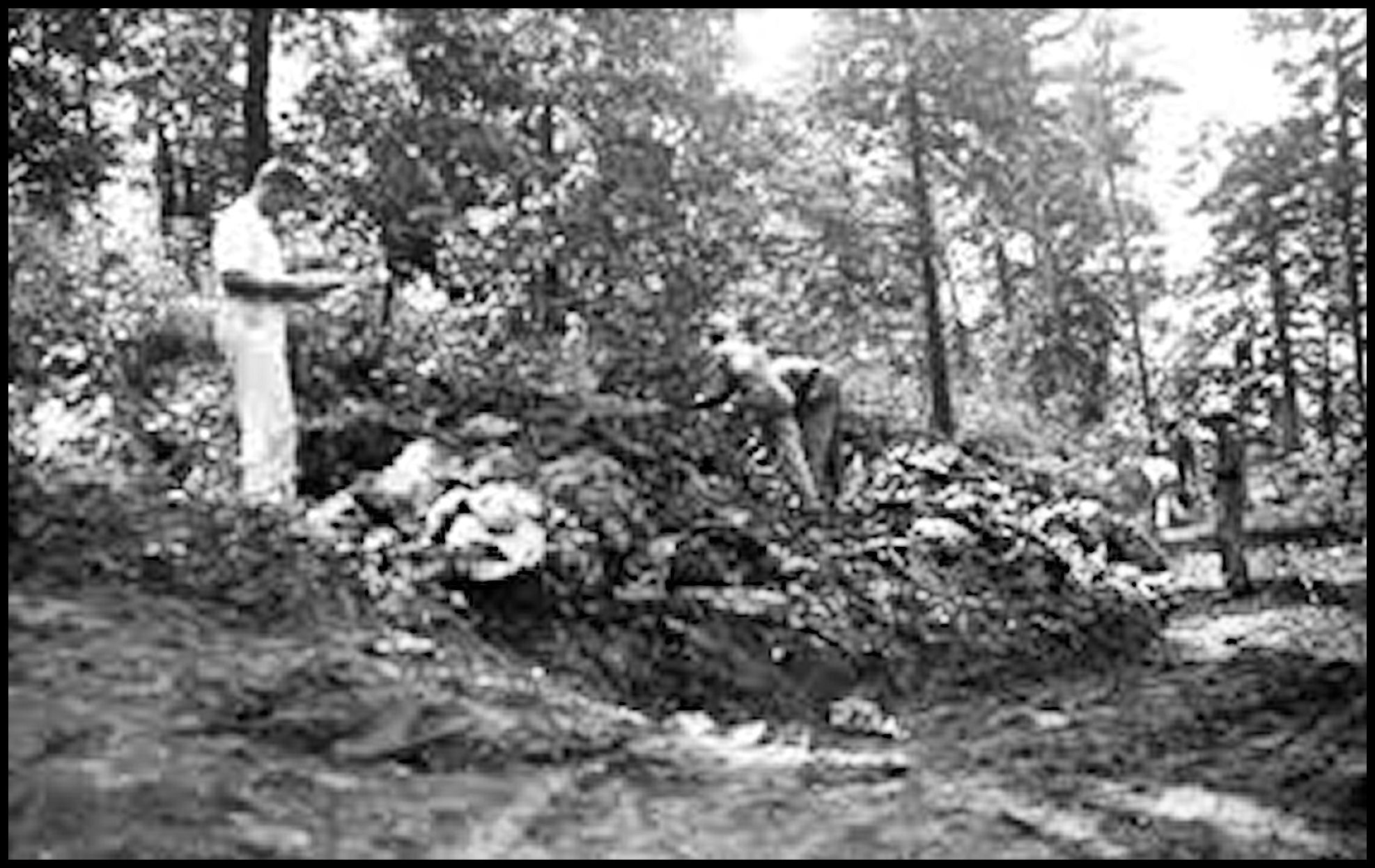
Shaw Stone Mound
The Shaw Mound was a stone burial mound at the foot of Ladds Mountain that was dismantled circa 1940 to collect the stones for road fill and to satisfy the curiousity of the landowner. A single individual was found within, buried with several items of copper, including a celt (axe), breastplate, and a cutout; large sheets of mica atop the face and chest; and stone celts. Scraps from the production of such items are abundant at the nearby Leake site.
A very frustrated archaeologist with the National Park Service, Calvin Johnson, watched as the stone mound was dismantled by laborers and loaded on to dump trucks. He found a royal burial with copper and stone artifacts as the base. No one knows what happened to the skeleton of an important male leader, after he excavated it. At least some of the artifacts are curated at the Antonio Waring Archaeological Laboratory at the University of West Georgia.

Wow i’m amazed, speechless.
LikeLike
I was delighted to find this blog as I’m having such a difficult time finding information about this site and its inhabitants. I live in Cartersville and I’m haunted by the image of the burial Shaw burial mound. I’ve sat at the red light that now stands right where the photographer probably stood to take this picture. To the right of me a McDonalds, a carpet factory, a grocery store… so much history destroyed.
LikeLiked by 1 person
Yes! I lived in Cartersville from 1995-1999 and had the same feeling when I first saw those photos.
LikeLike