Early County, Georgia
31° 28′ 17.28″ N, 84° 55′ 45.72″ W
by Richard L. Thornton, Architect and City Planner
Kolomoki was founded by a people, whose descendants were part of the Creek Confederacy 1700 years later. However, the town’s second (Weeden Island) phase represents immigration by Southern Arawaks. It is highly likely that the founders of the original Late Woodland village at Cahokia were descended from Kolomoki.
Kolomoki Mounds was a ceremonial site and large town in Southwest Georgia that was occupied from around 0 AD to 750 AD . . . and again briefly by ancestors of the Creeks, associated with the Lamar culture. Kolomoki is considered one of the most sophisticated and largest Woodland Period archaeological zones in the United States. Unlike most contemporary Hopewell Culture sites, it was a true town in addition to having ceremonial functions.
There are numerous inaccurate statements made about Kolomoki in its Wikipedia article. It is not clear, who wrote them, but any attempts to correlate the article’s wording with the latest archaeological and ethnological information is quickly deleted anonymously. Although described in Wikipedia as one of the oldest Woodland Period town sites in the Southeast, there are several along the Chattahoochee River upstream in Georgia, which were much older.
The archaeological site was comprehensively investigated by archaeologist William Sears in the late 1940s and early 1950s. Sears incorrectly interpreted the town as belonging to the Late Mississippian Period, because it contained multiple mounds and a dominating ceremonial mound. Work by such archaeologists as Thomas Pluckhahn in the late 20th century conclusively proved that it was a Woodland Period town site. Kolomoki Mounds was listed as a National Historic Landmark in 1964 and is also listed on the National Register of Historic Places.
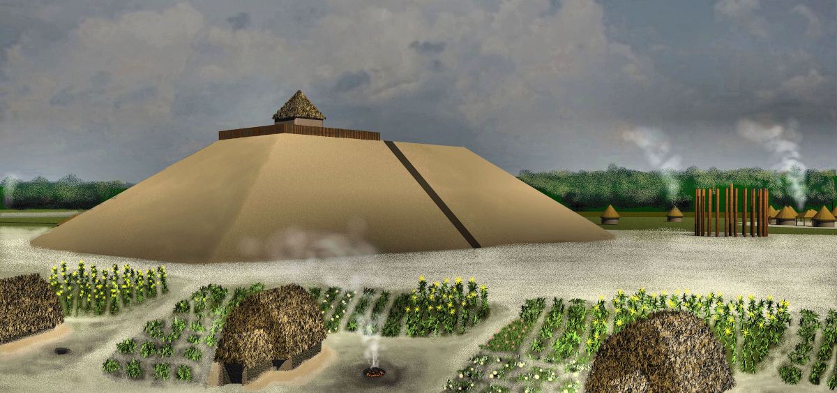
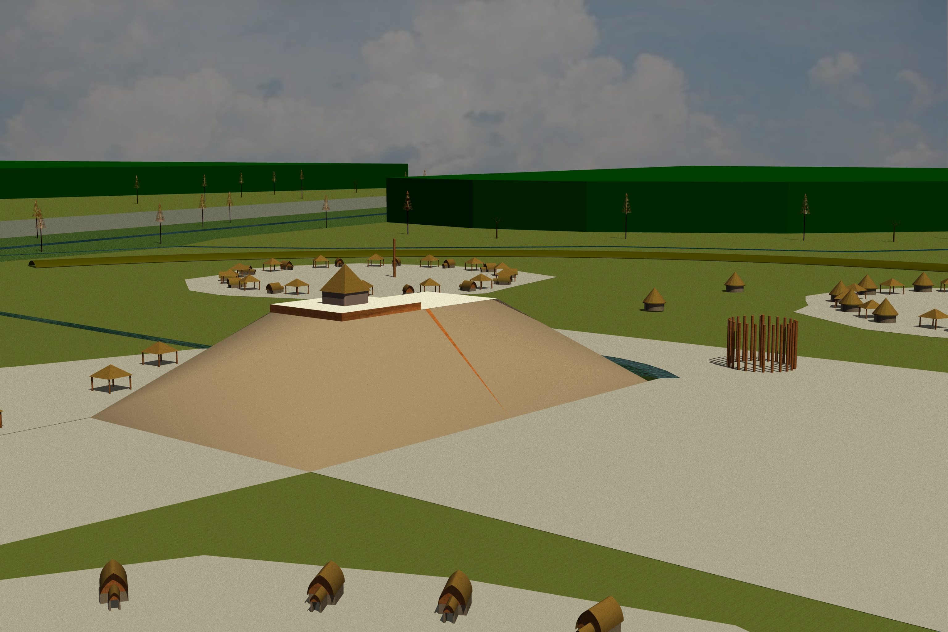
Kolomoki’s greatest construction activity and population density occurred between around 250 AD – 600 AD. The earliest radiocarbon date for a mound base is 30 AD. The archaeological zone contains at least eight mounds, plus other earthworks, a plaza and ponds. Mound A is today about 56 feet (17m) tall, but 1500 years ago, it was at least 75 feet tall. Massive mounds of earth compact, subside and erode over time in wet climates like Southwest Georgia.

A location in “the middle of nowhere”
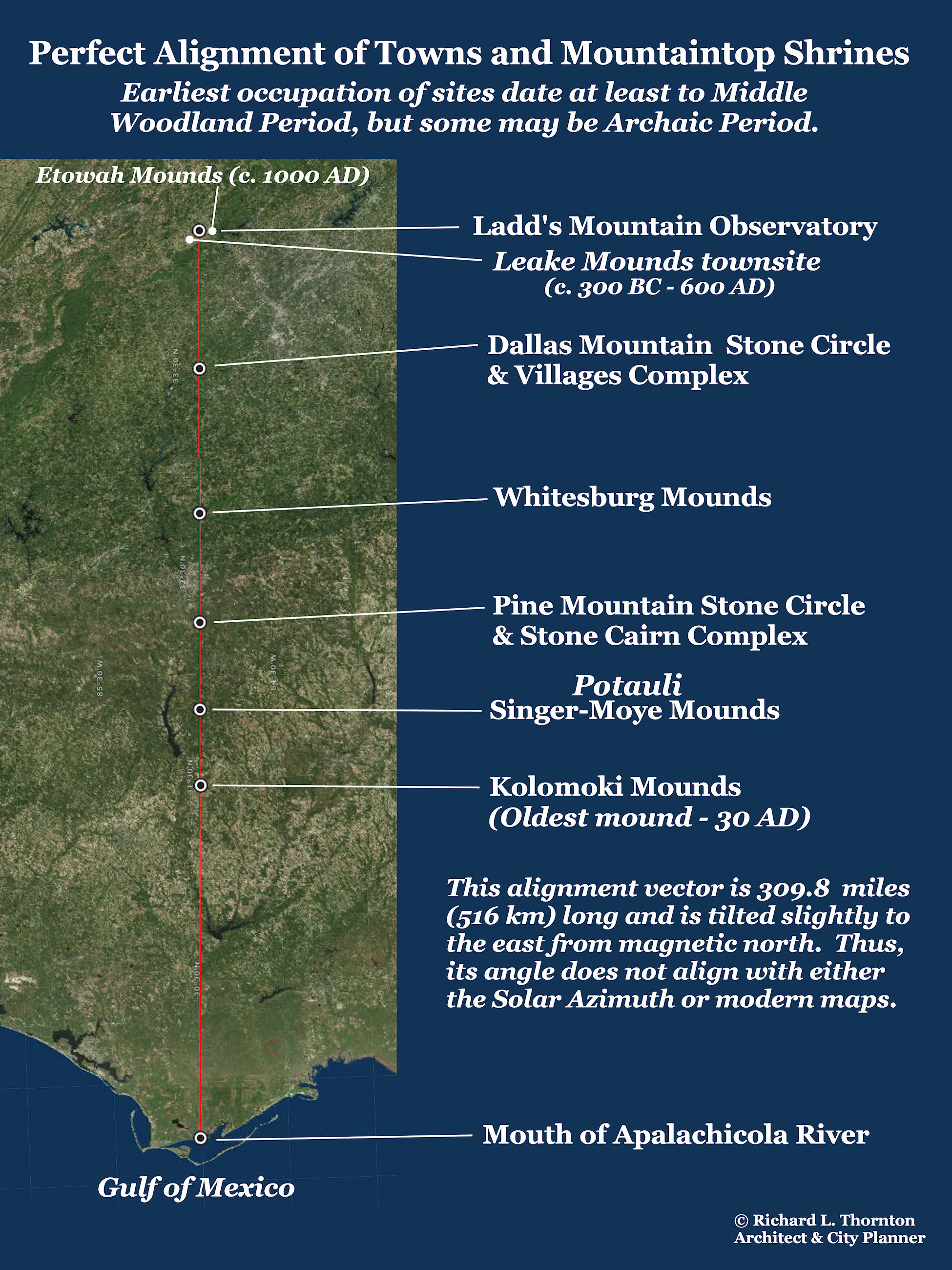
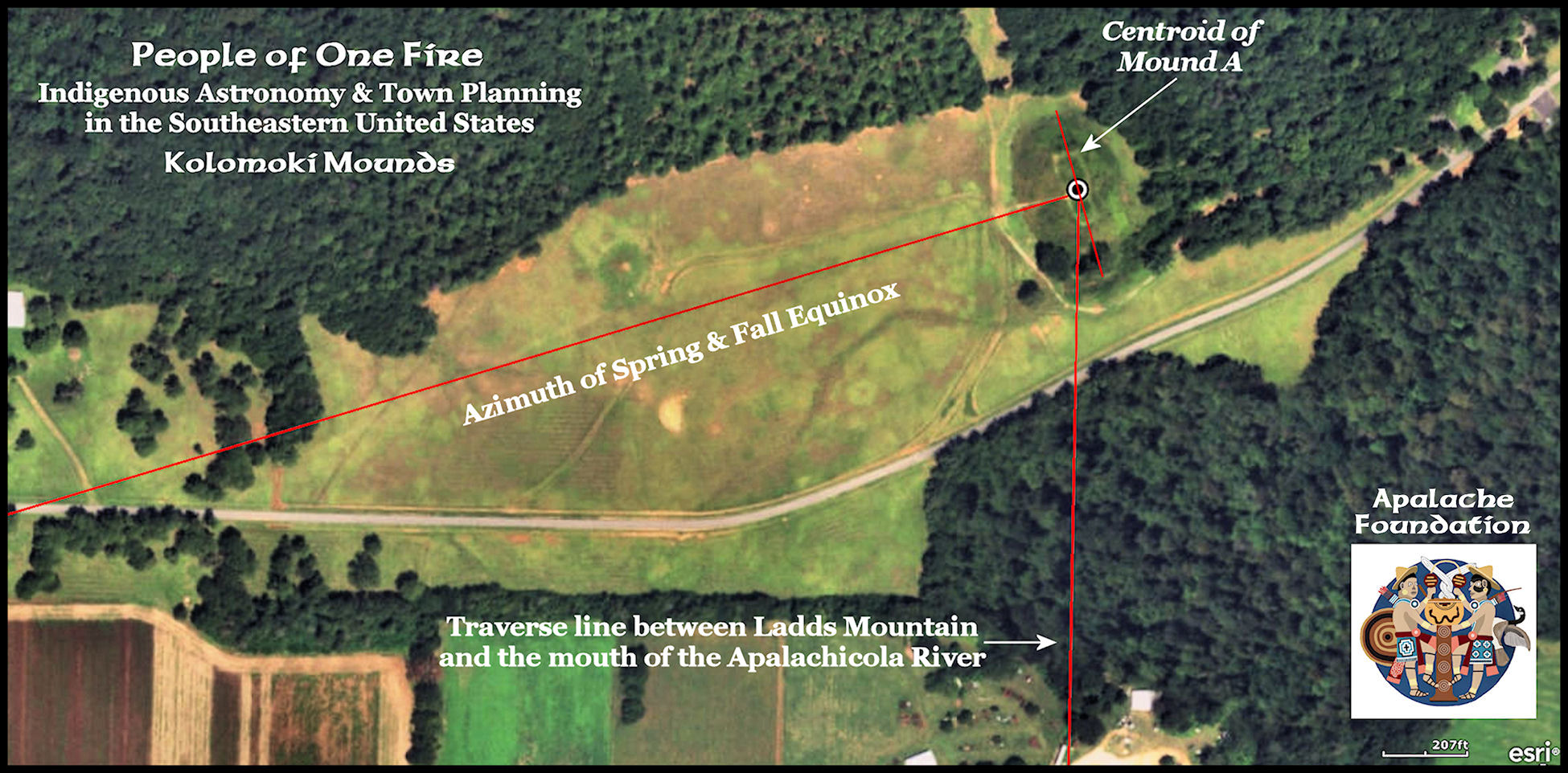
Archaeologists have long pondered why Kolomoki was constructed in a seemingly remote location, eight miles from the nearest major river . . . the Chattahoochee. A geospatial analysis revealed that the selection of the site for Kolomoki was based on the intersection of two massive surveyor’s traverse lines. The vertical line runs 309.8 miles (516 km) between the mouth of the Apalachicola River to the stone observatory on Ladd’s Mountain, near Etowah Mounds. The diagonal line is aligned to the azimuth of the Spring and Fall Equinoxes and runs between the mouth of the Mobile River and the center of Kolomoki Mound A. This vector is 186 miles (310 km) long. How the town’s builders accomplished this feat of long distance surveying? We have no clue.
Two “signature” types of architecture, woodhenges and keyhole houses, that Midwestern archaeologists assume are unique to the region of Southern Illinois around Cahokia Mounds, actually appeared at least 500 years earlier at Kolomoki. Fifty years after Kolomoki was abandoned, they appeared at Toltec Mounds near Little Rock, Arkansas then a hundred years later at Cahokia. These two types of architecture will be discussed further with the virtual reality images at the end of the article. Apparently, descendants of Kolomoki founded the original village at Cahokia.
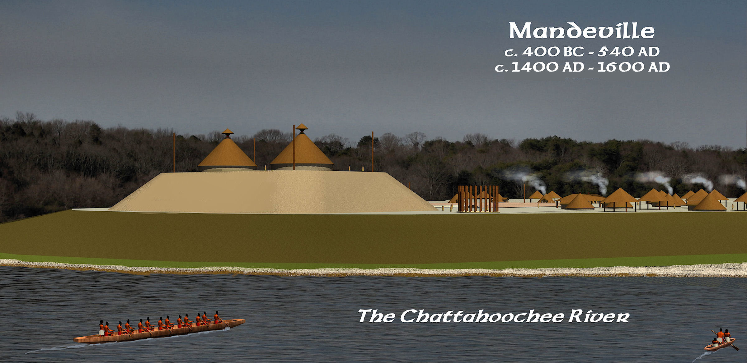
Settlers from Mandeville
The real name of this remarkable indigenous town is not known. The name Kolomoki is the Anglicization of the name of a branch of the Creek Confederacy, who were called the Kolima-ki or Colima People. They were living in southwest Georgia, when Europeans reached this region, but not when the mounds were built. Like the Colima People in northwestern Mexico, these immigrants were fond of producing pottery in the shape of Chihuahua dogs.
It was noted by the members of the De Soto Expedition that the indigenous peoples of Alabama, Georgia and South Carolina maintained large numbers of these small hairless dogs as household pets and sources of protein. The Creek Indians also had at least two other larger species of dogs. The medium sized one was kept as a companion to keep deer out of fields. The large sized one was used for hunting and tracking enemies.
The much larger, but still hairless Xoloitzcuintli was also utilized as a pet, but had a primary function of guarding the village against raiders and large predators. An even larger dog with hair was used for hunting. It was the same breed as what is now called the Carolina Dog or Dixie Dingo. For unknown reasons, the hairless dogs became extinct by the late 1700s, but many of the Dixie Dingoes went feral. In recent years, they have become recognized again as a distinct breed of dog, indigenous to the Southeastern United States.
Mandeville Site: The town site that archaeologist Arthur Kelly called Mandeville, probably functioned as the port of entry for Kolomoki on the Chattahoochee River. However, it was much older than Kolomoki. Mandeville was founded around 400 BC and began producing the oldest known examples of Swift Creek Pottery around 100 AD. One of those many “dirty little secrets of Creek history” is that “Swift Creek pottery” was being produced by the Conibo People of eastern Peru much earlier . . . but is also very similar to the Lapita Style stampled pottery of western Polynesia. Mandeville did not grow to its maximum size until after Kolomoki was declining, but eventually occupied about a fifth the land area covered by Kolomoki.
Kolomoki began around 0 AD or earlier as a small village and ceremonial site for peoples, who were little different than those elsewhere in the region. They made a style of pottery that was descended from ancient Deptford Style pottery, which originated on the Atlantic Coast in present day Savannah, GA then spread to the Georgia Mountains, where a dense population developed along the Upper Chattahoochee River. Presumably, these settler came down the Chattahoochee River to found a large ceremonial center, but their motivation remains a mystery. The earliest Kolomoki pottery was either stamped with simple check patterns, cord-marked or left with a burnished finish.
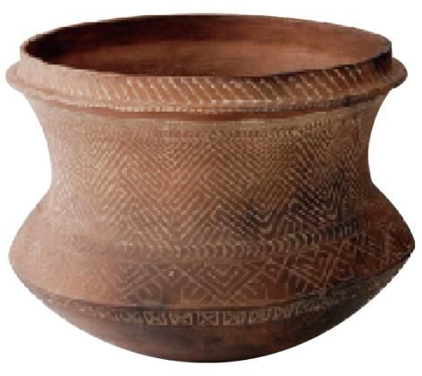
Around two centuries later, an elaborate new style of pottery made its first appearance in the Southeast at the Mandeville Town Site on the Chattahoochee River, southwest of Kolomoki. From there its popularity spread to almost all of Georgia. Called Swift Creek Style by archaeologists, it consists of elaborate curvilinear designs, stamped with wooden paddles, onto the soft, un-fired clay bodies. At the time (1961) that the famous archaeologist, Arthur Kelly discovered that the oldest and most ornate Swift Creek pottery examples were found at Mandeville and then Kolomoki, he assumed the older Swift Creek ware would eventually be found farther south in Florida. This has not happened. The Swift Creek Culture spread southward into Florida from Georgia. That means that the immigrants, who introduced Swift Creek came from much farther south than Florida.
Strong Peruvian influence on Creek cultural traditions
It is no accident that the first appearance of Swift Creek pottery was in the southwestern corner of Georgia. This style of pottery first appeared among the Conibo People of Eastern Peru and the Swift Creek motifs are still found in their elaborate textiles. The Creek language contains several Conibo words, such as the words for beans, tobacco, the Sacred Black Drink and village chiefs. Both the Conibo and modern day Creek Indians are known for the “Stomp Dance”. Brightly colored, traditional Creek and Seminole Indian clothing and head turbans are also very similar to that worn by the Panoan peoples of Peru and Amazonia, which include the Conibo.
Most of the mounds were begun during the period when Swift Creek pottery predominated at Kolomoki. However, a new cultural influence from the south began manifesting itself at Kolomoki around 350 AD. Called the Weeden Island Culture after an archaeological site in Florida, this artistic tradition reflected strong Arawak influence. In particular, the ceramic portrayals of human figures at Kolomoki resemble contemporary ceramics in parts of Colombia. The synthesis of Swift Creek and Weeden Island cultural influences sparked a rapid population growth at Kolomoki, which seems to have been more of a ceremonial site in the Swift Creek Cultural Period.
Probable influence on the Late Hopewell Culture
Many archaeological texts by academicians living outside the Southeastern United States label Kolomoki a “peripheral Hopewell Culture site.” Absolutely not . . . the town apparently was initially a colony of the town at the Mandeville Site, which was founded around 400 BC. The artifacts produced at Kolomoki are not similar to Hopewell artifacts. However, Swift Creek pottery HAS been found at Hopewell sites in Ohio and also at Pinson Mounds in western Tennessee.
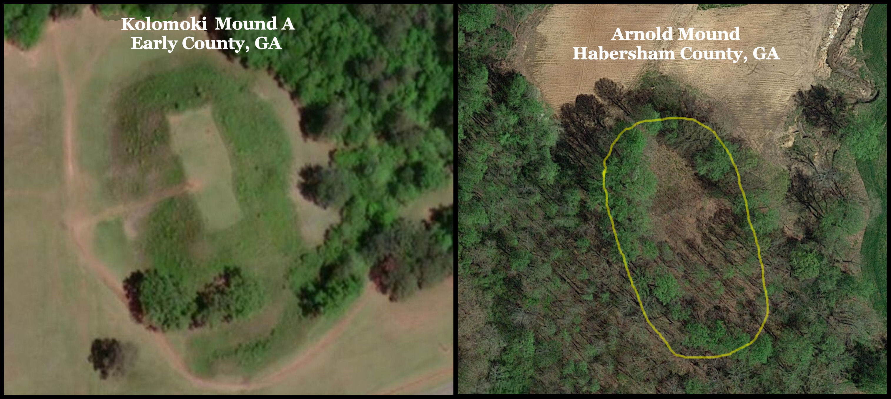
The Seip Mound near Paint Creek in southeastern Ohio is one of the largest Hopewell Culture mounds. It is the same shape as Kolomoki Mound A and the Arnold Mound in Northeast Georgia (see below) , but still considerably smaller than either of them. Archaeologists now believe that the Seip Mound was constructed during the last phase of the Hopewell Culture and reflected culturally influences from Georgia. It addition to the mound being shaped like those at Kolomoki and the Arnold Site, one finds both locally produced Check Stamped pottery and imported Swift Creek Pottery – both styles typical of Georgia during the Woodland Period.
Natural disaster depopulates SE Georgia and NE Florida
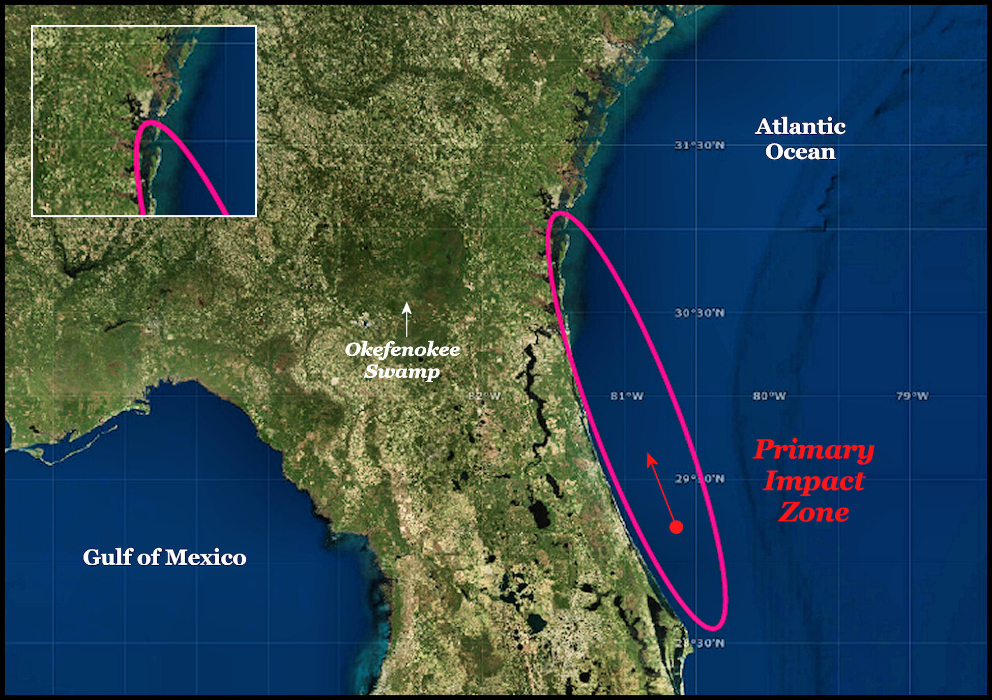
Around 539 AD, a large asteroid or comet struck diagonally off the coast of Cape Canaveral, Florida and caused a catastrophic tsunami on the coast of Georgia, which probably covered much of Southeast Georgia with water. During the same period super-volcanoes erupted in Central America and Iceland, which caused a Little Ice Age for several decades. The Maya civilization went into hibernation for 50 years. Europe entered the Ice Age. The Hopewell Culture disappeared and Kolomoki entered a period of steady decline. By 750 AD, the location had very few residents, but its cultural influence remained in the region.
Difference between Apalache, Apalachicola and Florida Apalachee
The indigenous cultural tradition that the Spanish and contemporary anthropologists call the Florida Apalachee apparently began during the late occupation of town sites such as Kolomoki, but never traveled much farther up the Chattahoochee River. Although anthropologists label the Florida Apalachee, a Southern Muskogean People, they created this orthodoxy without bothering to translate their town names at the time of initial contact with the Spanish. * They are almost all South American words.
The name of their capital, Anihaica or Anihica, means “Elite-Place of” in the Southern Arawak language, spoken in parts of northeastern Peru and Amazonia. Even Apalachen, the first “Apalachee” village visited by the De Soto Expedition, is a Panoan word from Peru. It has no meaning in the Muskogean languages other than being a proper noun. Apalachen is the plural of Apalache in Panoan. However, the true Apalache were concentrated on the Apalachee River and its tributaries in Northeast Georgia.
* The so-called Apalachee dictionary that one sees on the internet and in books by Florida academicians is actually a glossary of words spoken by a band of Tamale Creeks from the Altamaha River in Southeast Georgia, who were exiled for converting to Roman Catholicism. The authors of this glossary was the friars at the Mission San Martin de Tomale and nearby missions, where these Creek refugees lived.
The ethnic name, Apalachicola is not a Muskogee word that means “People on the other side” as stated erroneously by early 20th century ethnologist, John R. Swanton. It is the Europeanization of a Panoan and Apalache-Creek word, which means, “From-ocean-descendants of-People.” The actual Apalache word is Aparasi-kora. Creeks and the Panoans in Peru rolled their Rs so hard that most Europeans write the sound down as an L.
According to Creek tradition, the true Apalache established colonies in Southwest Georgia and the Florida Panhandle among the descendants of Kolomoki. The true Apalache built the Great White Path (US 129) to interconnect their provinces in the North Carolina Mountains, Georgia and Northwest Florida. They introduced what anthropologists call Mississippian cultural traditions to the locals on the Gulf Coast. The elite in Northwest Florida were from North Georgia and spoke a language similar to modern day Miccosukee. The elite called their province Tula-halwasi, which means “Descendants from the Highland Towns.” By the 1500s, those living in the Florida Panhandle were speaking a dialect of Southern Arawak that the true Apalache in North Georgia could not understand, but nevertheless, the two peoples remained on friendly terms and had long established trade relations.
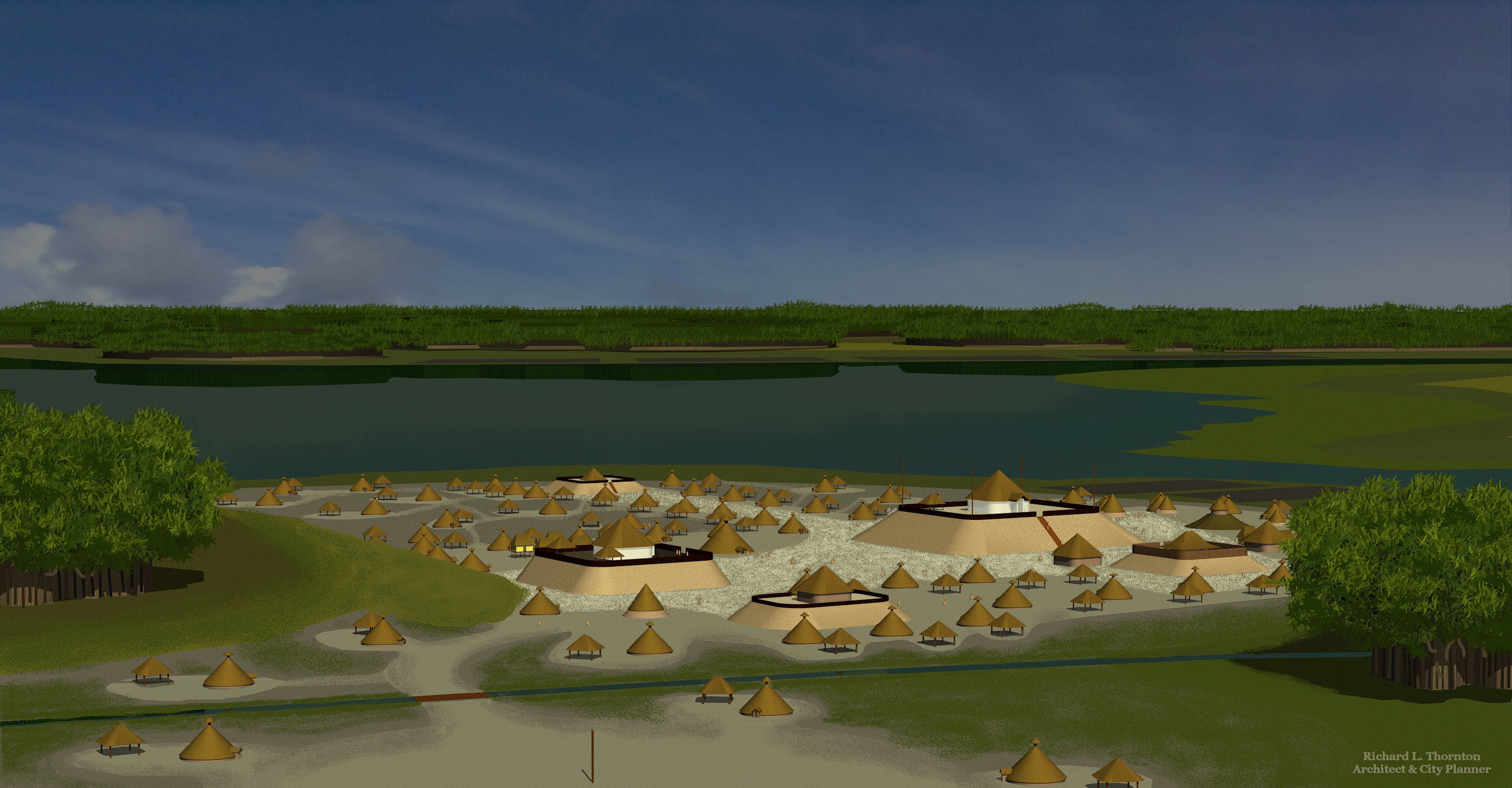
The Architecture of Kolomoki
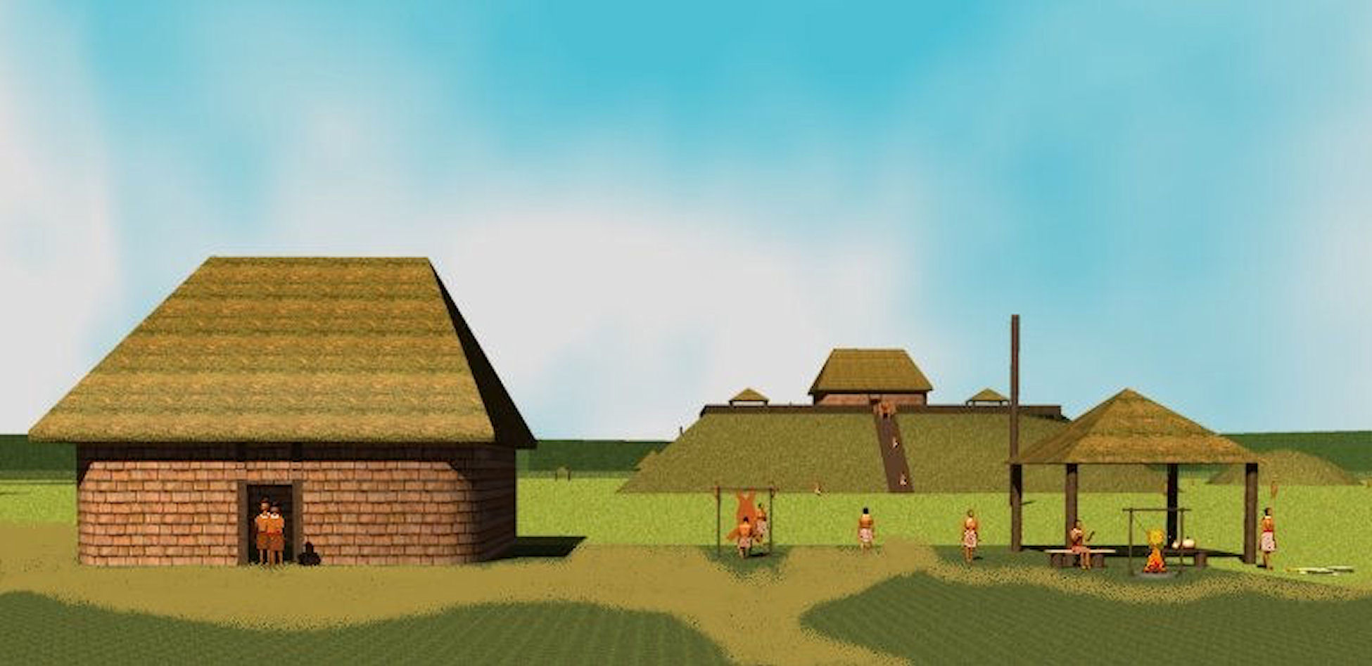
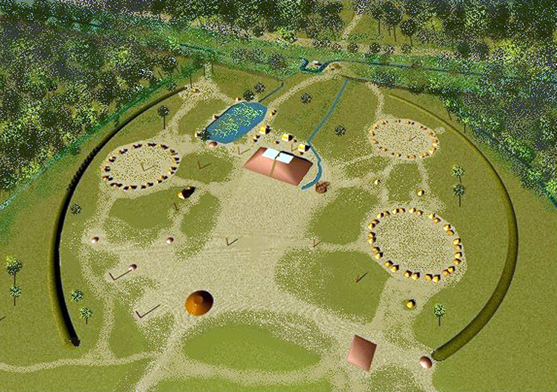
The town plan of Kolomoki consisted of a large pyramidal mound tilted at angle of about 14 degrees and facing a plaza and group of mounds to the southwest. These mounds have precise geospatial relationships that mark the key dates on the solar azimuth. The vector of Mounds D and F define the Spring and Fall Equinox. Mounds B and C are clustered near Mound A and define the Summer Solstice and locations of constellations. Mound B was actually a compact woodhenge, which functioned as a sun dial. The vector between Mounds C and D marked the Winter Solstice. The vector between Mound D and E, plus F and G, were aligned to the Pleiades Constellation. Two semi-circular earthworks originally defined the public plazas from the residential areas. They were also aligned with the Pleiades. During the latter stages of Kolomoki, some houses, perhaps for priests and attendants were built inside these arcs.
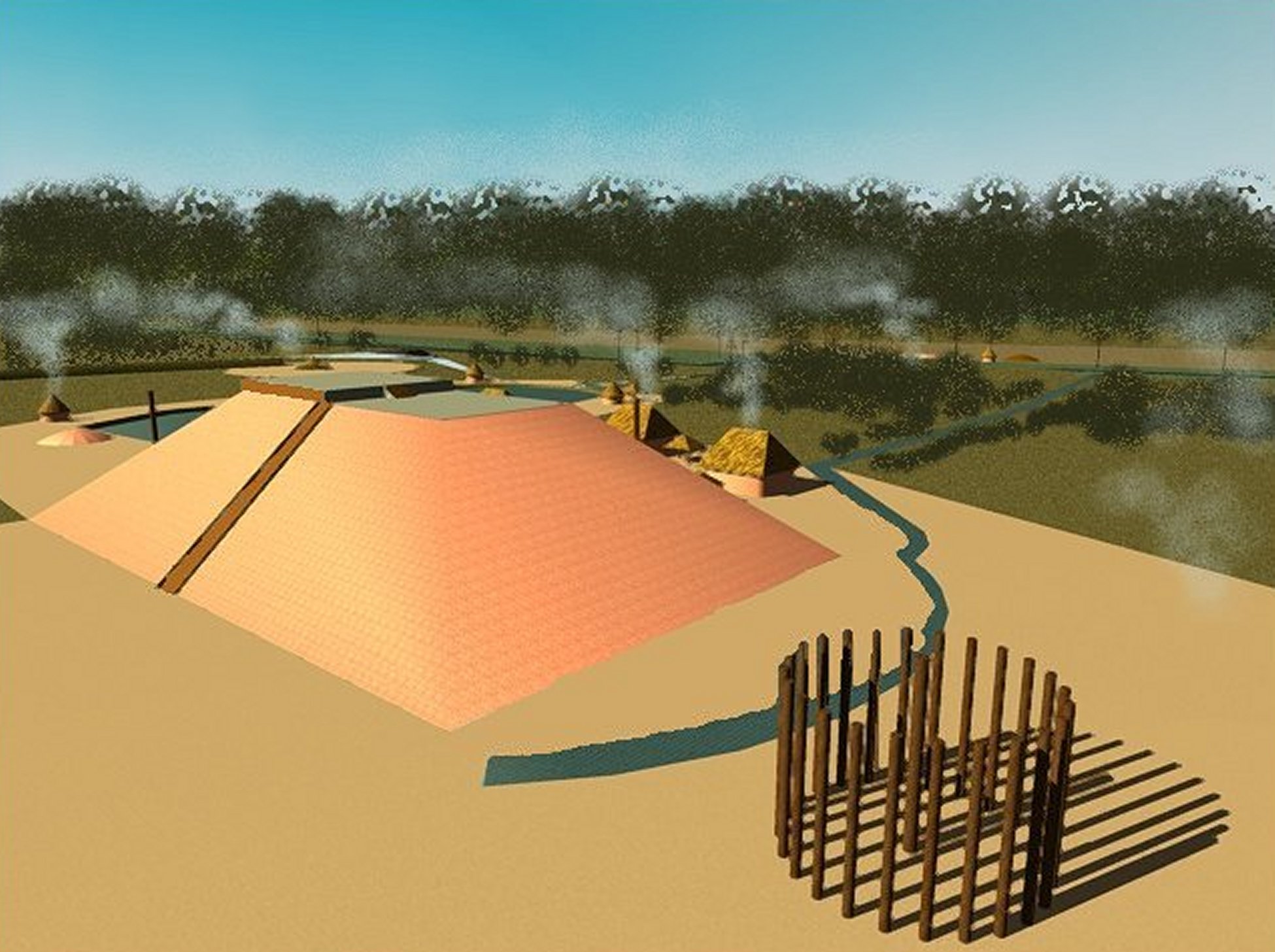
The occupants of Kolomoki obviously had a severe problem with flash floods . . . particularly around Mound A, whose steep slopes caused rain water to rush down its sides into the plaza. A stormwater drainage system was constructed, whose details exact match those required by building codes for 21st century land developments. Drains were constructed around the base of the massive mound. A catchment pond was built on its south side. Overflow from the catchment pond was drained to Kolomoki Creek to the east. The entire plaza was sloped to drain to a much larger pond on the north side of Mound A. Its overflow also drained to Kolomoki Creek. The people at Kolomoki also built drainage ditches outside the semi-circular earthworks, which drained residential areas.


Fascinating, as usual. Didn’t know about the tsunami in 539.
LikeLike