Indigenous American Planning and Surveying Series
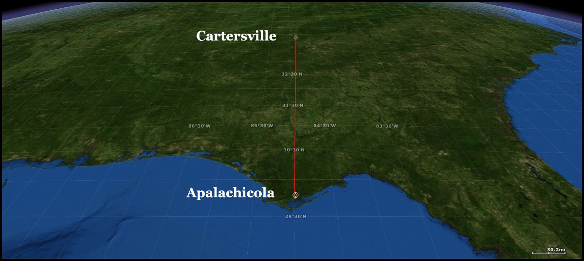
An astounding, perfect alignment of six ancient towns and mountaintop shrines prove that a thousand years before the construction of towns at Ocmulgee National Historic Park and Etowah Mounds National Historic Landmark, the people of the Southeastern United States had skills in astronomy and land surveying far exceeding any contemporaries in the Old World. However, the fact that the starting point for this 310 mile long vector is at the mouth of the Apalachicola River suggests that these town planners originated from somewhere to the south . . . at a minimum the far western tip of Cuba.
One will occasionally see the same comments in academic texts about Kolomoki Mounds and Singer-Moye Mounds (Potauli). The author ponders why Kolomoki Mounds and Singer-Moye Mounds were built around 8 and 12 miles, respectively, east of the Chattahoochee River . . . along modest creeks that were barely navigable for small dug out canoes. Almost all the other great towns of the the Lower Southeast were built along rivers, which could support massive freight canoes, up to sixty feet long.
This seems to be a significant question, but there were no speculations from the academicians. While in college, the archaeologists’ professors had not given them the orthodox answer to this riddle, therefore the former student did not dare say something that might be criticized by his or her peers.
Kolomoki is located in southwest Georgia. It is named after the Kolima-ki Creeks, who lived in that region during the Late Colonial Period. Kolomoki apparently began as a religious shrine or location for a regional market. A smallish burial mound has a starting date of about 30 AD, but most of the construction occurred between 300 AD and 550 AD. An asteroid or comet struck the South Atlantic Coast in 539 AD, creating a massive tsunami that covered most of southeast Georgia with water. Almost simultaneously, several massive volcanoes erupted in Central America and Iceland, bringing on a Little Ice Age. As a result, the Hopewell and Swift Creek-Weeden Island Cultures quickly disappeared. The Maya Civilization went into hibernation and Europe entered the Dark Ages.
The Singer-Moye Mounds Site is also in southwest Georgia and is located 25.6 miles (42.7 km) north of Kolomoki. It is one of the Southeast’s best preserved mound sites, and contains Georgia’s fourth largest mound. The Creeks called this town Potauli. Most of the mounds date from the period from 900 AD to 1600 AD, but Woodland Period pottery and artifacts have been found at the lowest layers. This suggests that there was a village or shrine site here during the Woodland Period.
The actual town plans of Kolmoki and Potauli are different from each other and from the alignment of the town sites. They will be discussed in separate articles in this series. Potauli’s plan had the same alignment as Teotihuacan, which was associated withe Pleiades constellation.
As in so many other situations, the actual descendants of the people, who built these towns, want to know the answers. There are are too many unanswered questions about our ancestors that have been glazed over with simplistic anthropological models of the past then fossilized by academic politics. It is very difficult to argue with hard numbers, so I used ERSI GIS software to analyze these two town sites.
Methodology
Digital benchmarks were placed on the centers of the two largest mounds at Kolomoki and Patauli. The software then drew a line between the centerpoints. I then told the computer to extend the vector line southward. It passed over the mouth of the Apalachicola River on the Gulf of Mexico. Curious as to whether this vector also applied to archaeological sites farther north, I instructed the software to extend the vector northward. I then merged this digital map with another digital basemap, which showed the archaeological sites explored by Robert Wauchope in North Georgia during 1939. Several Woodland Period archaeological sites were exactly on this vector line. Three were mountaintop stone shrines or observatories. I was not able to identify any correlations north of the Ladds Mountain Observatory . . . although there may be some.
Conclusion
The maps speak for themselves. Kolomoki, Potauli, the Pine Mountain Stone Complex, Whitesburg Mounds, the Dallas Mountain Stone Complex and the Ladds Mountain observatory were all sited along a surveyor’s traverse line. How indigenous town planners, 2,000 years ago, were able to accomplish this surveying feat. I do not know.
In the past, I have been able to explain alignments of individual town plans to the Solar Azimuth by the use of “high tech” sun dials. However, this is different situation. The vector angle does not align with either True North or Magnetic North . . . so primitive compasses are not another option.
Thus, we now have another question . . . “How in the heck did they do it?”


Also, on the 83rd are both Serpent Mound in Ohio and Young Lick Mountain in GA:
https://en.wikipedia.org/wiki/Young_Lick
“Young Lick is a mountain that lies in three Georgia counties, Habersham, Rabun and Towns. Its summit – Young Lick Knob, elevation 3,809 feet (1,161 m), is one of Habersham County’s highest points. Young Lick Knob is crossed by the Appalachian Trail.
Young Lick is a “triple-divide” peak on the Eastern Continental Divide, with rainfall from its summit flowing into three completely separate major basins. To the northeast of the peak, water flows into the headwaters of the Savannah River and into the Atlantic Ocean. To the southeast, water flows directly into the Gulf of Mexico via the Chattahoochee, then Apalachicola rivers. To the west, water also flows to the Gulf, but it follows a less direct route via the Hiawassee, Tennessee, Ohio, and Mississippi river systems.”
LikeLiked by 1 person
That is extremely useful information. I live in NW Habersham County and our research team is now focusing on the Batesville Area, where we are finding some amazing things. Thank you !
LikeLiked by 1 person
https://grahamhancock.com/maglionegrimason1/
Found the above linked article to be interesting after having read this a while back. Not necessarily any connection but with all the mounds and US sites destroyed it would be hard to tell.
LikeLike
I’m in the Apalachicola area now and unless there are a ton of mound septic tank systems, there are small flat topped mounds everywhere. In lots of yards and in woods. Couple of potential mounds on the Eglin base on Cape San Blas too. Close to confirmed shell midden site I visited. Read some places to Econfina Creek was a longtime Creek Outpost and it is a beautiful trail.
LikeLiked by 1 person
I have often suspected that the archaeologists missed a whole bunch of mounds in the Apalachicola area. You can see many of them on satellite imagery. Florida archaeologists have also conveniently “forgotten” excavations upstream along the Apalachicola River, which don’t jibe with their current orthodoxies. Like . . . did you know that the oldest “Hopewell Culture” artifacts were found at a town site when the Chipola River joins the Apalachicola? That tells us the the Hopewell “people” came from South America and that what academicians are called the Hopewell Cultural Sphere was actually the movement of peoples from south to north.
LikeLike