by Richard L. Thornton, Architect & City Planner
Their mixed-blood descendants joined the Creek Confederacy and contributed several words to the Muskogee-Creek language. In 1935, Smithsonian Institute archaeologist, James Ford, found ancient bronze and iron weapons & tools along the banks of the Altamaha River in southeast Georgia in the section, where the Alekmanni once lived. According to the National Park Service, most of these artifacts were put on display in the museum at Santo Domingo State Park near Darien, Georgia. However, the Georgia Division of Parks and Historic Sites refuses to cooperate with our repeated efforts to locate these artifacts today.
Ten years ago, I would have considered the following essay pure heresy . . . but that was 10 years ago. Little did I know that in six weeks, I would be involuntarily launched, with three days notice, on a two year odyssey through the Appalachian Wilderness . . . that my dogs would get thirsty for water in the summer sun, while I was photographing the Track Rock Petroglyphs . . . that we would cross the road in search of water and behold a mountainside covered with terraces . . . but this article is not about the Itza Mayas, but Bronze Age Europeans.
Last night, I was watching another episode of “The Vikings” on my computer monitor, while eating dinner. In all its gory detail, the portrayed a springtime blood sacrifice to the Goddess Freya for a good harvest, healthy livestock and lots of human babies. I was astonished to see the blood of a bull being poured into a basin carved into a boulder. It was identical to the basin above on the right side.
It is extremely difficult to do architectural-anthropological research on the “new” pro-commerce version of Google, when using English search words, so I searched in Swedish for more information on those stone basins. I discovered that the stone basins were an integral part of Neolithic and Bronze Age religion in Scandinavia and northern Germany. Such rituals were continued by the vanliga folk (common folk) during the Iron Age. The Old English words were wanlika folk. So this scene was accurate history . . . as promised by the producers of this TV series.

There are hundreds or thousands of such basins in the Southern Highlands and Piedmont. Some have spouts for the liquid to pour down. Some don’t. Those without spouts were probably used for a ritual in which priests dropped pebbles into the water to see into the future via concentric ripples of water.
Archaeology books and articles tell us that these basins were used for “crushing nuts.” Long ago my Granny Ruby (real name – Mahala) hollered out hogwash!, when the Atlanta Journal described them as places where Indians cracked open chestnuts. Granny Ruby reminded us that you have to roast chestnuts, chikapins, walnuts and hickory nuts in their shell so they won’t mold and can be cracked easily. That would be much more easily accomplished back in the village, not in the woods.
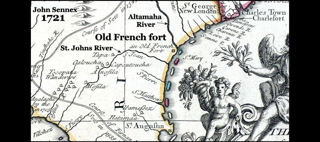
The mysterious Alecmanni
I didn’t much about this stone basins, until I became more aware of the many petroglyphs in the Southern Highlands and then read the English translation of Captain René de Laudonnière’s memoir. De Laudonnière was commander of Fort Caroline. Both he and some letters sent home by other colonists describe a powerful, sophisticated tribe, living about 25 miles up the May (Altamaha) River, where Jesup, GA is today. Of course, Florida writers mislabel the St. Johns River as the May and tell us that the Alecmanni mysteriously disappeared from “Florida” as soon as a fort was established in St. Augustine. However, all French, Spanish, English and Dutch maps during the Colonial Period up to 1722, label the Altamaha as being the May. After that date it was called the St. George, Coweta or Altamaha River.
De Laudonnière tells us that the Alecmanni specialized in the cultivation of medicinal plants. Their tribal name meant “Medicine People” in their own language. Their most valuable crop was cinchona from which quinine was made. They traded cinchona bark to the Apalache in the Georgia Mountains for gold, mica, crystals and food products. Their large freight canoes were constantly paddled up and down the Altamaha-Oconee-Ocmulgee River System.
Alek is the Eastern Creek is the word for both medical doctor and medicine. The equivalent in Oklahoma Muskogee Creek is Vlek, which is pronounced Aw-lek . . . so De Laudonnière ‘s interpretation of Alecmanni was right on target. Alec Mountain, close to where I live now, gets its name from the impressive stone ruins on its crest, which apparently was a place where Alecmanni/Creek medical doctors lived or where sick people went to get healed.
More proof . . . in the 1730s Mary Musgrove established a trading post on the Altamaha River, 25 miles upstream from where colonial maps showed the location of Fort Caroline. Early maps called the village Alectown, but later that was changed to Doctortown. There is today a state historical marker at Doctortown.
I assumed that “manni” was the word for “people or tribe” in some South American language, since the Alecmanni cultivated and marketed cinchona trees. For years I tried to find that language, but couldn’t.
Then while soaking in the bath tub one night, I remembered that in high school Latin, we had to read Julius Caesar’s commentary on the Gallic Wars. He mentioned several tribes in northern and western Germania, whose name included a “manni” suffix. In fact, the French, Spanish and Portuguese languages’ word for Germany was derived from the German tribe, named the Allemanni, which means “All men or all people.” Well, there it was, but it couldn’t be. To say such a thing would be a heresy.
Further sleuthing revealed that in the old Germanic and Norse languages, the plural of commoners was “men” but the plural of “big men” or noblemen was either manni or menni. Menni was used by the ancestors of the Norwegians and northern Swedes. Manni was used by the southern Scandinavians, northern Germans, living near the North Sea and the western Germans. SO . . . we know that the ancestors of the Alecmanni came from the same region where the Frisians, Angles, Jutes and northern Saxons lived. In other words, they were ancestors of the English! That group of tribes and languages is labeled Ingaevones today, after a name given them by the Romans.
What about the word, alek? I remembered that läka (pronounced leka) was the Southern Swedish word for medicine or medicinal herbs and läkare (pronounced lekare) was the Swedish word for medical doctor. Danish and Norwegian use entirely different words, BUT Anglisc, the original language of the Angles in Scandinavia, used the exact same words for medicinal herbs and “healers.” Both Anglisc and Old English attached an “a” in front of a common noun or verb to create an action noun. Thus, the use of medicinal herbs to heal was aleka. In colloquial Southern Appalachian English, we still say such phrases as “I am a-going or I am a-coming.”
The Old English word for medicinal herbs today survives as the name of a particular plant, leeks. Even today in England and northern Europe, this member of the onion family is considered to have curative powers. Ramps, the beloved cure in the Appalachian Mountains for all that ails you, is closely related to the Wild Leek of Northern Europe. It is possible that ramps are actually a feral cultivar of European leeks that was brought across the Atlantic 2-4 thousand years ago.
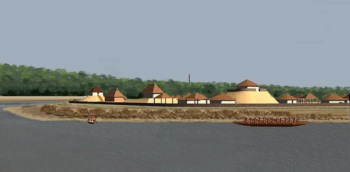
What about the artifacts? In his famous book about his travels around the Lower Southeast, William Bartram described a visit to the earthen ruins of a trapezoidal French or Spanish fort on the Altamaha River, about 11 miles inland from the sea. The ruins were exactly where all Spanish, French, English and Dutch maps placed Fort Caroline and Fort Mateo, plus the exact distance from the Atlantic, described by Captain René de Laudonnière.
The fake 1/12th scale model of Fort Caroline in Jacksonville, which was built in 1961, is three miles from the sea. Fort San Mateo was a much smaller earthen fort, built by the Spanish after they razed Fort Caroline. Fort Caroline was a triangle, 1800 feet in length. Fort Mateo was a trapezoid about 300 feet in length.
However, near the earthen ruins are several tabby (early form of concrete) ruins, which early 20th century scholars in Georgia decided was where Bartram actually visited. They also decided that what he saw was not a “French or Spanish fort,” but the ruins of the early 17th century Spanish mission building, Santo Domingo de Asao de Talashe (1595-1667). One of the nation’s first state parks was created there – Santo Domingo State Park. It included the earthen ruins, adobe ruins, plus an 18th century rice and sugar plantation.
After President Franklin Delano Roosevelt announced the creation of the National Park Service, the State of Georgia nominated Santo Domingo State Park to be a national park. It was directly adjacent to US Highway 1A, which connected the Northeast with Florida. The NPS contracted with the Smithsonian Institute to carry out a archaeological survey of Santo Domingo, in order to determine its eligibility.
James Ford, at that time a very young archaeologist, was directed to drop his work at Ocmulgee Mounds and spend some time on the coast. At that time, he had no actual academic training in anthropology and only three years of liberal arts education from the University of Mississippi. Ford HAD been trained by the famous archaeologist, Dr. Arthur Kelly, how to excavate artifacts.
Ford dug test pits around the tabby ruins and the level land between them and the earthen ruins. In his last phase of work, he excavated test pits along the banks of the Altamaha River. That is when he found most of the iron artifacts. Without any excavations, Ford dissed the earthen ruins as merely being “an old Indian mound” and therefore, made no effort to study them.
Between the tabby and earthen ruins Ford found a dense accumulation of bronze tools, plus 16th century French and Spanish ceramics, tableware and tools. The bronze swords, daggers and axes were at the lowest level. Betraying his lack of formal education, he interpreted this site as a temporary camp, established by the Spanish army in the late 1500s. Even in 1935, it was known that no bronze weapons were made in the Iberian Peninsula after around 500 BC! The iron broadswords, daggers, axes and shield buckles found elsewhere, were typical of the European Iron Age, but Ford also classified them as Spanish Colonial artifacts. He correctly interpreted the tabby ruins as being 18th century sugar and rice mills.
Based on Ford’s archaeological report, the National Park Service sent a letter to the state of Georgia five years later, stating that the site was of little historical significance and therefore not suitable for a national park. Today, we would find their appraisal of 18th industrial buildings to be ludicrous, but such were the times.
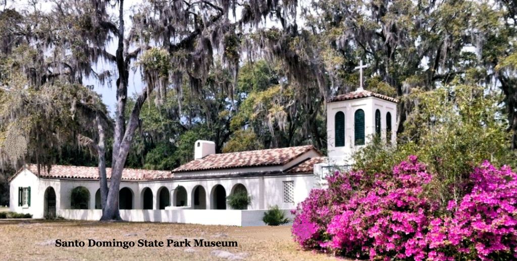
In the meantime, the State of Georgia had built a charming museum, which mimicked the architecture of much later California missions. The Smithsonian kept “some” of the artifacts that Ford had found, but most went into the museum. The state was highly disillusioned about the project after it got the negative letter. In 1947, the state park was closed and converted into a orphanage. In the 1960s, the orphanage was given to the Southern Baptist Association of Georgia to replace their Hapeville, GA orphanage, which was torn down to make way for expansion of the Atlanta Airport. That orphanage was ultimately closed and now the museum in a private mental health outpatient facility.
After reading James Ford archaeological report in 2013, I immediately sent an email and then a formal letter to the archaeologists at the Georgia Division of Historic Preservation, inquiring about the current location of the Santo Domingo artifacts. I never received a response.
In November 2014, I traveled down to Savannah to receive an honor at the annual conference of the National Trust for Historic Preservation . . . the only person from Georgia receiving said honor. While there, I drove down to the Fort St. George State Historic Site in Darien, GA to inquire about the whereabouts of the Santo Domingo artifacts. Initially, the new director and her staff were very interested and helpful . . . then the director called someone in Atlanta. A frown came on her face. She then called each of her staff to her desk. Afterward, no one would speak to me. Anything else I said would be speculative.
Ed Reilly, a very active volunteer with our research efforts, volunteered to take on the task of finding the lost artifacts. He made personal visits to Darien and Brunswick, GA plus sent out several letters. People were not as rude to him (initially) as they were to me, but ultimately he hit a stone wall. It became obvious to us that someone high up in the bureaucracy of the Georgia Department of Natural Resources DID NOT want anybody to see artifacts that would prove a European presence long ago in the Southeast or that the real location of Fort Caroline was across the Altamaha River from Darien. And that is still the situation to this day.

TO: Richard Thornton
FROM: Eric Koperek = erickoperek@gmail.com http://www.worldagriculturesolutions.com
SUBJECT: Stone Basins
DATE: PM 3:09 Sunday 10 November 2019
TEXT: The stone basins you photographed appear closely similar to Colonial era basins used for small-scale distillation of pine tar. Iron kettles were stuffed with fresh pine sticks. The kettles were inverted over stone basins. The edges were sealed with clay. Firewood was laid around and over the kettle. When the fire was lighted, the heat would start a process known as “dry distillation” = “destructive distillation” resulting in a thick black liquid called “pine tar”. The pine tar collected in the basins. Pine tar was used both for medicine (salves and soap) and to help seal bark roofs of log cabins. I am well familiar with this technology. As a boy we made pine tar for construction projects. I am NOT saying that your thesis is incorrect, only that your stone basins may not be as old as you speculate. I advise you to measure the dimensions of your stone basins. I think you will find that they closely match the dimensions of the most common Colonial cast iron pots. Nota Bene: I have also seen stone basins used for cooking (by dropping hot stones into water). These basins are usually deeper than those you have photographed. The basins with spouts are almost certainly from Colonial and later times. Books printed in Colonial times contain drawings and descriptions identical to your photographs. ERIC KOPEREK.
LikeLike
Both locations are and were entirely deciduous trees. Also, adjacent boulders contain very ancient petroglyphs that are identical to those of Bronze Age Ireland and southern Scandinavia. Take a look at our videos on the People of One Fire Youtube channel. I created five videos on the petroglyphs of northern Georgia.
LikeLike
Sounds like we need to continue the search for what happened to those bronze tools and weapons Ford is said to have found.
You probably know that we have what appears to be a sacrificial stone up here in the NE at America’s Stonehenge in NH. In case you didn’t know, it’s been reported that the stone has been vandalized.
https://www.unionleader.com/news/crime/sacrificial-stone-at-america-s-stonehenge-vandalized-with-power-tool/article_f12416d6-5e7f-5796-bd18-3cbfeb32221f.html
Some parts of the story as reported appear to be questionable.
LikeLike