by Richard L. Thornton, Architect & City Planner
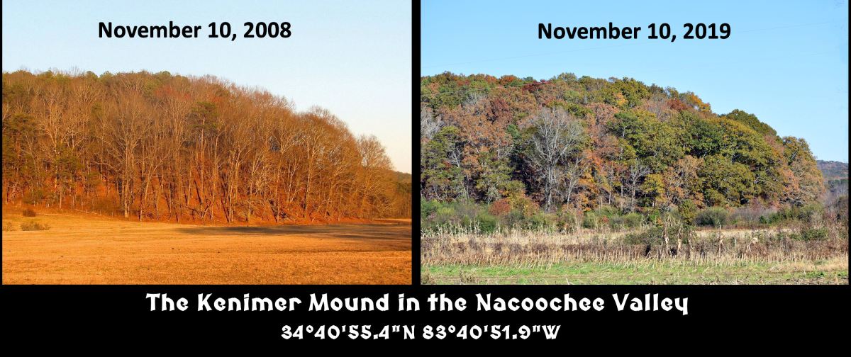
The two photographs above, taken 11 years apart are dramatic proof of how Mother Nature is responding to changing climatic conditions. As late as the early 1990s, the time of peak leaf color in the Georgia Mountains was around October 15. This year (2019) it will be around November 15. That coincides with a statement made by professional farmer, Allan Fritchey, who grows vegetables for his farm market about three miles east of the Kenimer Mound. He said that in the past 20 years, his growing season has lengthened by two months! He quipped that climate change has been good for him financially, even though it is harming other regions.
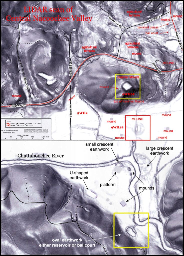
A LIDAR scan in 2016 revealed dozens of mounds in the Nacoochee Valley that were missed by the famous archaeologist, Robert Wauchope, in 1939. This scan is a one square mile section of an archaeological zone that covers seven square miles. The Kenimer Mound is the diamond-shaped structure in the upper right side of this image. It is in a yellow box. Note the many mountainside terraces in this image, which are normally hidden by trees.
–
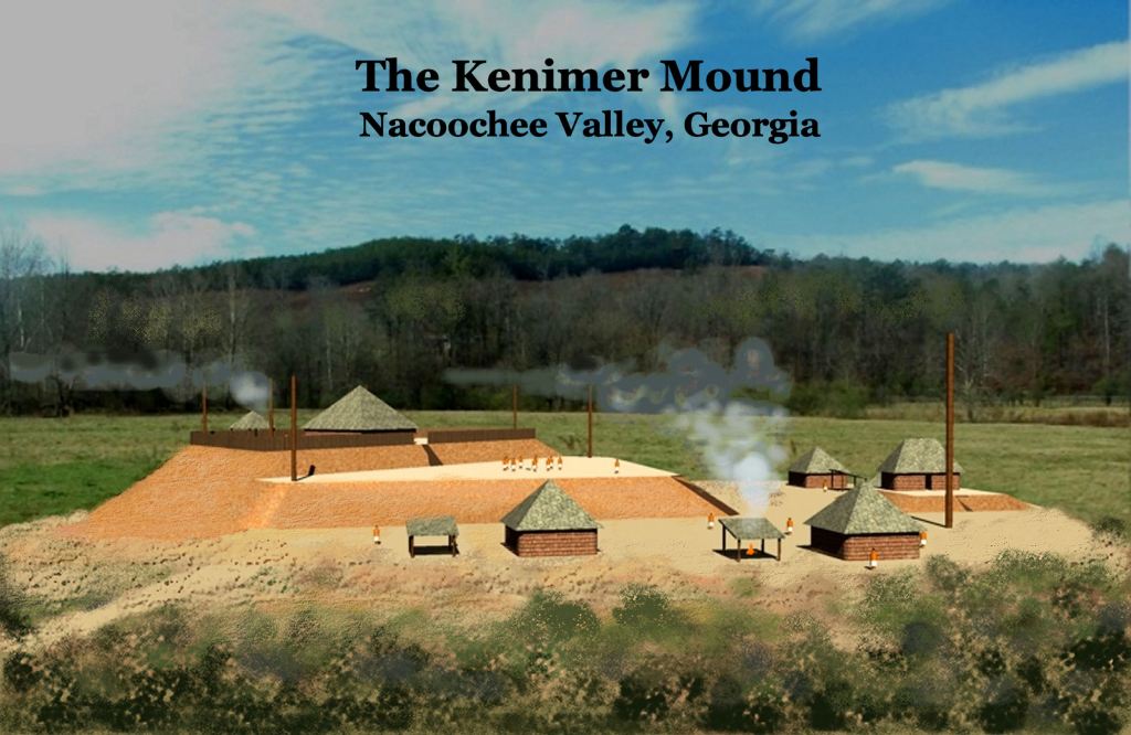
The Kenimer Mound is a little known, but extremely large Native American mound that dates (at least) from the early Late Woodland Period (c. 550-700 AD). In 1999, archaeologists from the LAMAR Institute at the University of Georgia carried out a two survey of the site and found Napier Style potsherds on the surface of mound, which are known to date from around 600 AD to 800 AD.
Robert Wauchope excavated mounds and village sites around the periphery of Kenimer Hill for a year without knowing that the biggest mound lay on hilltop above him. Perhaps it was so large that from a distance, he assumed it was a natural feature. The late Dr. Tom Lumsden was a water boy for Wauchope’s many digs. He tried to persuade Wauchope to climb the hill to look at the formation, but he never did.
Long time residents of the Nacoochee Valley told me that until the late 1970s, the ruins of stone temple were on top of the mound and there were several man-made terraces, supported by stone walls on the slopes of the hill around it. These ancient stone structures were removed by family moving from Florida, who used the rocks to build a chimney and retaining walls at their new “mountain fantasy” home.
In January 1986, Archaeologist David Halley of the University of Georgia and his friend, Jim Langford, climbed up Kenimer Hill and after looking over the earthworks, declared them to be a Native American archaeological site. It was soon after that the Kenimer Mound was first officially designated as a archaeological site by the State of Georgia.
Thirteen years later the team of professors and students from the University of Georgia surveyed the mound and dug test pits in search of artifacts. In 2008, the owner of the Kenimer Mound told me that a written agreement had specifically forbidden the archaeological team from digging on the site. She was surprised and obviously not given a copy of the archaeological report or returned the artifacts excavated . . . which were legally her personal property.
It was also at this meeting that Tom Lumsden became so angry at me that he turned red-faced and walked away. He insisted that the Kenimer Mound was built by the Cherokees as a place where they could dance the Sacred Eagle Dance. I told him that the Cherokees were nowhere around in 600 AD and that the ancestors of the Uchees, Chicksaws and Creeks built all the mounds in the Nacoochee Valley. In fact, Wauchope specifically stated in his 1966 book, An Archaeological Survey of Northern Georgia that he looked for a Cherokee village site in the Nacoochee Valley for a year and could not find one. He never found a single artifact that could definitely be associated with the Cherokee Indians.
There is a strange, religious fervor to those whites in Northeast Georgia, who have decided they are part Cherokee, even though they have no Native American physical features and almost never have any Native American DNA in them. If anything unusual shows up at all in their heritage, it is typically a combination of Semitic, Iberian (Portuguese/Spanish/Asturian) and North African DNA. They are descended from 17th century Sephardic Jewish gold miners.
When a prominent local family invited me to present my book, The Nacoochee Valley . . . Ancient Crossroads of the Americas, the white Cherokees in the Sautee-Nacoochee Community Association did everything they could to block the slide lecture. The book is strictly a compilation of the archaeological reports published by several famous archaeologists. I had no idea that there were so many other archaeological sites, missed by these archaeologists, until I moved here and began studying the LIDAR scans. The white Cherokees forced this family to pay rent on the SNCA auditorium and the organization’s leaders to send out notices that the SNCA didn’t endorse my “controversial” book or me personally . . . as if I was some immoral vagabond – not an award-winning architect. Nevertheless, we had standing room only.
A definite association with Mesoamerica
The principal reason that Georgia archaeologists have generally ignored the Upper Chattahoochee-Soque River Basins is that the town sites and mounds are very different than the orthodoxies that they were taught in college, but are identical to contemporary town sites in the Highlands of Tabasco, Chiapas, southern Guatemala and western Belize. Smithsonian Institute ethnologist James Mooney stated in his famous book, Myths of the Cherokee, that the massive town that ran along the Chattahoochee for two miles was named Itsate. That is the word, which the Itza Mayas called themselves.
The biggest difference in the mounds in Northeast Georgia is, like the mounds in the Maya Highlands, are often, but not always, sculpted from existing hills. Sections of hills were excavated in order to obtain fill dirt to create precise geometric forms.
High school history books and college anthropology books teach North American students that the Southeastern “Mound-Builders” constructed compact, fortified towns, in the flood plains of large rivers. The town sites in Northeast Georgia are sprawled out in corridors from a half mile to three miles long, often in the hilly terrain overlooking river or creek flood plains. The principal Itza and Kekchi Maya mounds, dedicated to their sun god, were virtually identical to the Kenimer Mound.
With the owner’s permission, the Kenimer Mound is one of the locations that our volunteer teams will be studying this winter. Although driving past the Kenimer Mound several times a week, I have not seen this remarkable structure either!
