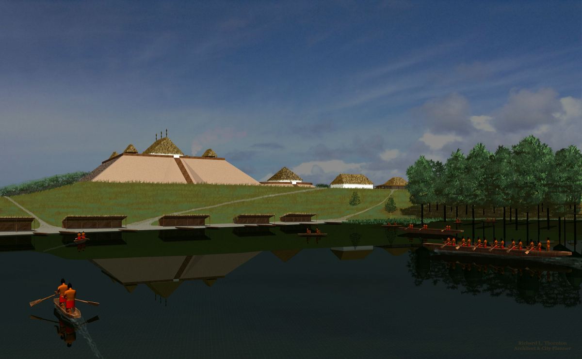
by Richard L. Thornton, Architect and City Planner
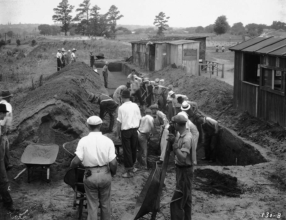
The excavation of the acropolis and some satellite villages at the Macon Plateau was the largest archaeological project ever carried out in the United States. The initial phase involved hundreds of WPA employed laborers, two men with college degrees and two college dropouts. A recent Georgia Tech graduate and professional Civil Engineer, Joe Tamplin supervised the work on a daily basis, while Harvard graduate and professional archaeologist, Arthur Kelly, was responsible for over-seeing all WPA archeological work in Georgia.
Symptomatic of the misunderstandings about the massive archaeological zone are the descriptions of Tampin in “Ocmulgee Archaeology,” a book written by several University of Georgia anthropology professors in 1986. Tamplin is mentioned twice in the book. In one place, he is called “a foreman.” In another chapter, he is called “a laborer, who showed up for the 50th anniversary of Ocmulgee National Monument.”
In his 2009 book, Cahokia, Illinois archaeologist, Tim Pauketat described Ocmulgee as “a small mound center out in the middle of nowhere.” Nowhere? The Southeastern United States is chock full of large and small Native American town sites, end to end. Chroniclers of the Hernando de Soto Expedition stated that they never lost site of houses or cultivated fields while in what is now the State of Georgia.
Dramatic discoveries on the Ocmulgee River from 1974 onward, plus the surprisingly late date of mound construction at Cahokia Mounds in Illinois, pinpoint Ocmulgee as the place where the so-called “Mississippian Ceremonial Culture” began. It was not a small town occupied by a single ethnic group, but a massive multi-ethnic megapolis, stretching for at least 38 miles along the Ocmulgee River. The megapolis was built on top of towns and villages that came into existence 2000 or more years ago. Construction of the acropolis mounds began 150 years before those at Cahokia.

Three of the most famous archaeologists of the 20th century, Arthur Kelly, James Ford and Gordon Wiley, were associated with Ocmulgee’s excavation in the 1930s. However, after the Nixon Administration moved the National Park Service’s Southeastern Regional Archaeological Center to Tallahassee, FL to punish Georgia for its senators being on the Watergate Investigation Committee, Ocmulgee National Monument slowly sank into oblivion as far as archaeologists elsewhere in the nation were concerned.
Meanwhile, anthropological texts about the Southeastern United States indigenous peoples, published in the past 20 years, have either barely mentioned Ocmulgee or not mentioned it all. If mentioned, it is treated as a small, culturally insignificant cluster of mounds in a remote location. Incredibly, Midwestern and Pacific Coast anthropologists are still being taught that Ocmulgee was founded by immigrants from Cahokia. That myth was discarded at least 60 years ago.
Especially in the past 20 years, multi-disciplinary studies have radically changed the understanding of the enormous Ocmulgee Bottoms Archaeological Zone. These challenges to past speculations are neither reflected in anthropological literature nor in the exhibits at the Ocmulgee Museum.
A dissertation in 2012 by Dr. Daniel Bigman for his Ph.D in Anthropology at the University of Georgia, can no longer be ignored by his profession. Ironically, Bigman was not aware of some of the most revolutionary implications of his findings, because his dissertation was not reviewed by a faculty member, who was knowledgeable about Southeastern indigenous architecture. However, his findings had a scientific basis and cannot be construed as speculations.
A very special place
Around 900 AD or earlier, immigrants began grading a terrace overlooking the Ocmulgee River for a town devoted to regional trade and religious rites. Its “full blown Mississippian” cultural traits preceded those at Cahokia by about 150 years. Construction stopped on the acropolis of the town around 1150 AD. The timing corresponds exactly to the abandonment of many large towns near Lake Okeechobee, Florida that apparently had a trade or cultural connection to Ocmulgee, but did not have agricultural based economies. That date also corresponds to when the Toltec capital of Tula in central Mexico was abandoned. There may or may not be a connection.
For eighty years tourists and anthropology students have been told that the town of Ocmulgee was completely abandoned around 1150 AD. Yes, construction apparently stopped at the acropolis, but Ocmulgee Bottoms was not abandoned. You will learn that some archaeologists have known for several decades that occupation continued in several satellite towns in the megapolis . . . at some locations until the early 1800s!
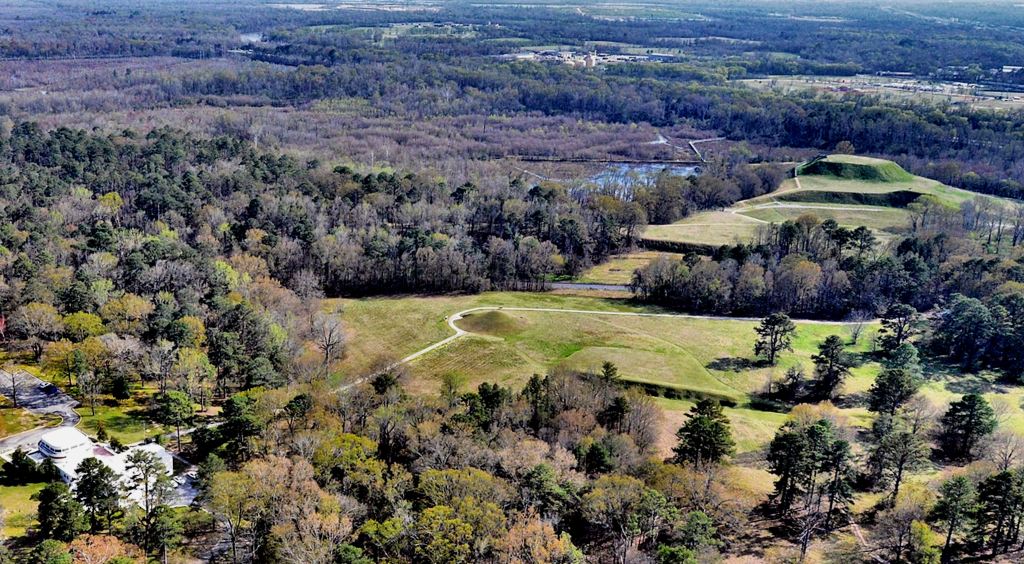
Ocmulgee Mounds National Historical Park is a unit of the National Park Service on the southeast side of the Ocmulgee River just below the Fall Line that separates the igneous Piedmont from the sedimentary Coastal Plain. It was originally planned in the early 1930s as a 2000+ acre national park, but a substantial chunk of the original tract purchased by the citizens of Macon was utilized for public buildings, public housing, highways or sold back to commercial investors. A 791 acre national monument was designated by Congress, which included the acropolis and initial ring of satellite neighborhoods of the town. In recent years, archaeologists have discovered that the Ocmulgee’s immediate neighborhoods extended northward to Fort Hawkins and across the river to what is now Downtown Macon.
The Ocmulgee Bottoms Archaeological Zone includes at least 48 indigenous town and village sites along a 38 mile long corridor. At least 26 of these sites were contemporary with the acropolis at the Park and were obviously satellite communities. Many of these satellite villages contained one or two small mounds. However, a large town on the east side of the Ocmulgee River in Twiggs County contains 28 mounds. It is owned by a paper company and not open to the public.
Members of organized Creek tribes and Creek descendants all consider Ocmulgee to be a sacred place. When I was six, my mother took me there. At the time, the burial of an important leader was on display in situ. My mother went there first and said, “Richard, this could be one of your ancestors.”
In June of 2014, Rep. Austin Scott, a Republican from Tifton, GA and Rep. Sanford Bishop, a Columbus, GA Democrat, filed a joint bill Thursday to create Georgia’s first national park. The bill called for the expansion of the national monument to a 2,000+ acre tract and to be changed to a national park status. The John D. Dingell, Jr. Conservation, Management, and Recreation Act, signed March 12, 2019, re-designated the Ocmulgee National Monument as the Ocmulgee Mounds National Historical Park.
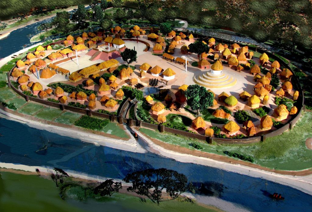
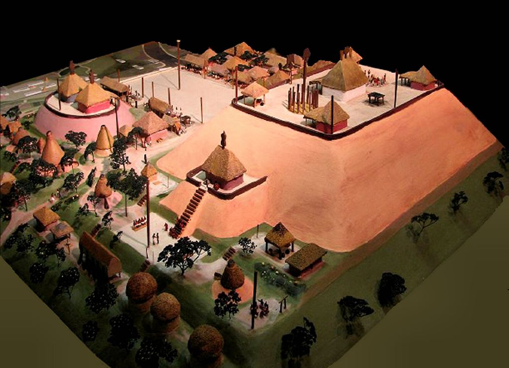
Ichesi ~ the 1974 Lamar Village Excavation
The Lamar Village is located two miles south of the Ocmulgee acropolis on a detached component of the National Park. Ichesi means “Corn – descendants of” in Itsate-Creek. The equivalent word in Mvskoke is Achesi. The word, Ochesee, sometimes used by archaeologists, is an Anglicization. The village, however, is typically called the Lamar Village by archaeologists and the Ocmulgee National Park staff. Currently, visitors are only allowed into the Lamar Village component by reservation. The site tends to get swampy in the late winter and can be heavily overgrown by vegetation in the summer.
It is named after the prominent Lamar Family, who in the early-to-mid-1800s played a major role in the expulsion of the Creek Indians from Georgia then acquired several large plantations in the Macon and Eatonton areas. The second president of the Republic of Texas, Mirabeau Buonoparte Lamar, grew up and lived on Lamar plantation lands until 1835. Lamar wrote and stated several times that “total extinction of the Indian tribes was necessary to make the lands available to whites.”
The archaeologists should have done a little research before calling it the Lamar Village. It was Mirabeau Lamar who ordered the brutal attack on peaceful Cherokee farmers in Texas that killed Chief Bowles, a friend of Sam Houston. In the research that Roger Kennedy and I did in 2011, we found that the primary reason for the Texas Cherokee massacre was that their land was considered ideal for cotton plantations.
The signage and literature at the Ocmulgee Museum tell visitors that the Lamar Village was founded around 200 years after the acropolis at Ocmulgee was abandoned or about 1250 AD. That statement is false.
In 1974, two National Park Service archaeologists excavated a section of the “Temple Mound” at Ichese, plus dug several test pits. They also ran radiocarbon tests of charcoal deposits. The results were big surprises that were soon published in a typed report for an archaeological conference held at the Park. For unknown reasons, the new information never got into the textbooks that anthropology students use around the country and are not reflected in the exhibits of the Ocmulgee Museum.
Ichese was founded at least as early as 990 AD by the same people, who simultaneously founded Etowah Mounds 116 miles (186 km) to the northwest. Residents of both villages made Etowah Complicated Stamp style pottery. However, the archaeologists also found much earlier styles of pottery in some locations, such as Swift Creek Complicated Stamped and Napier Complicated Stamped, This suggests that the site was intermittently occupied by hamlets much earlier.
The town was originally built on a horseshoe bend in the Ocmulgee River. So was Etowah. Etowah’s real name is E-tula, the Itza Maya word for “Principal Town.” Around 1200 AD, a massive storm of unimaginable ferocity struck Georgia. The Ocmulgee and Etowah Rivers cut across the horseshoe bends of Ichesi and E-tula, destroying many buildings and creating islands. Yes, the Etowah River originally flowed NORTH of the Great Mound there. You can see evidence of the former channel in the terrain.
There were major influxes of population at both Ichesi and E-Tula around 1250 AD. This is what started the “urban legend” that Ichesi was founded around 200 years after Ocmulgee was abandoned.
2004 Geospatial Analysis
In 2002, the rangers at Ocmulgee National Park went out of their way to help me financially by inviting me to sell my ceramics at the Southeastern Native American festival and then selling my ceramics at the museum shop. In late 2001, my architecture practice had been destroyed when some rogue federal law enforcement officers called up my clients and told them I was an “Al Quaida agent.” I learned the next year that after 60 years of federal stewardship, there was still no accurate site plan for Ocmulgee National Park. To show my gratitude to the rangers for their continued support, I prepared a site plan based on USGS topography, aerial photos and satellite imagery.
No one at Ocmulgee ever knew that while living in Virginia, I had been friends with National Park Service Director, Roger Kennedy and several of the senior archaeologists at the NPS Harpers Ferry Facility. I had even been on the original advisory council for the American Battlefield Protection Program. I figured that my financial circumstances had so deteriorated, after being stuck back home in Georgia after a surprise marital separation, they wouldn’t believe me. However, I was to collaborate again with Roger in 2010 and 2011, just before his death.
Within the first hour of this volunteer work, I was shocked to discover that ALL Native American mounds in the Ocmulgee Bottoms, dating from 900 AD onward, were aligned perfectly to a triangular matrix, set by the solar azimuth. For 60 years, archaeologists had missed this important fact because they apparently did not know that all modern maps are based on Magnetic North, not True North. For example, University of Georgia anthropologist, David Halley, commented in 1986 that the mounds had “strange 25 ½ degree orientation.” I used CADD to shift the map to True North and voila! The principal mounds were aligned to the Winter Solstice sunset, which is the beginning of the Maya New Year. .
Someone in the regional office of the National Park Service in Atlanta authorized a conventional land survey, costing about $10,000, in an effort to disprove my site plan. When they matched, the National Park Service’s copies of the site plan were evidently thrown in the trash can. However, the plan impressed the heck out of Muscogee-Creek Nation officials. This led to a series of projects for several clients over the next 10 years that could not be thrown in the trash can.
2005 Astronomical Study
The following year, Yale astronomy professor, Dr. Vance R. Tiede, started out with my True North site plan and then went several steps further. He went on site at Ocmulgee with sophisticated astronomical equipment and found that not only were all the major structures oriented to the Solar Azimuth matrix, but individual structures also functioned as “observatories” of the stars, planets and moon.
Tiede’s astronomical studies of Ocmulgee and the Town Creek Mound in North Carolina were published in several national professional journals for astronomers. They never seemed to make it into anthropological journals or the exhibits at the Ocmulgee Museum.
2006-2012 ~ Ocmulgee Archaeological Society
Under the leadership of professional archaeologist, Steve Halleck, the Ocmulgee Archaeological Society has made some discoveries that radically changed the size of the Ocmulgee Conurbation. There were satellite neighborhoods across the river in what is now Downtown Macon and close-in neighborhoods. Humans continued to occupy this area after there was no longer construction activity in the acropolis. However, anthropology books published outside of Georgia either don’t mention Ocmulgee or describe it as a small mound site that was permanently abandoned after 1150 AD.
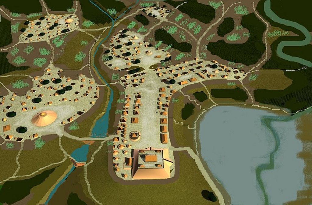
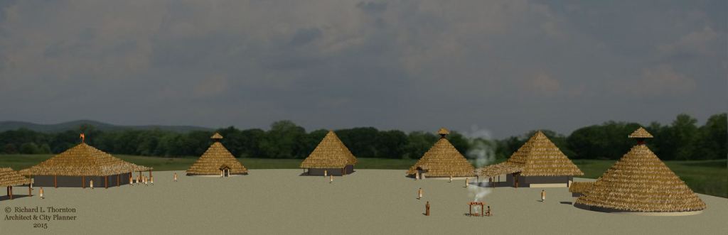
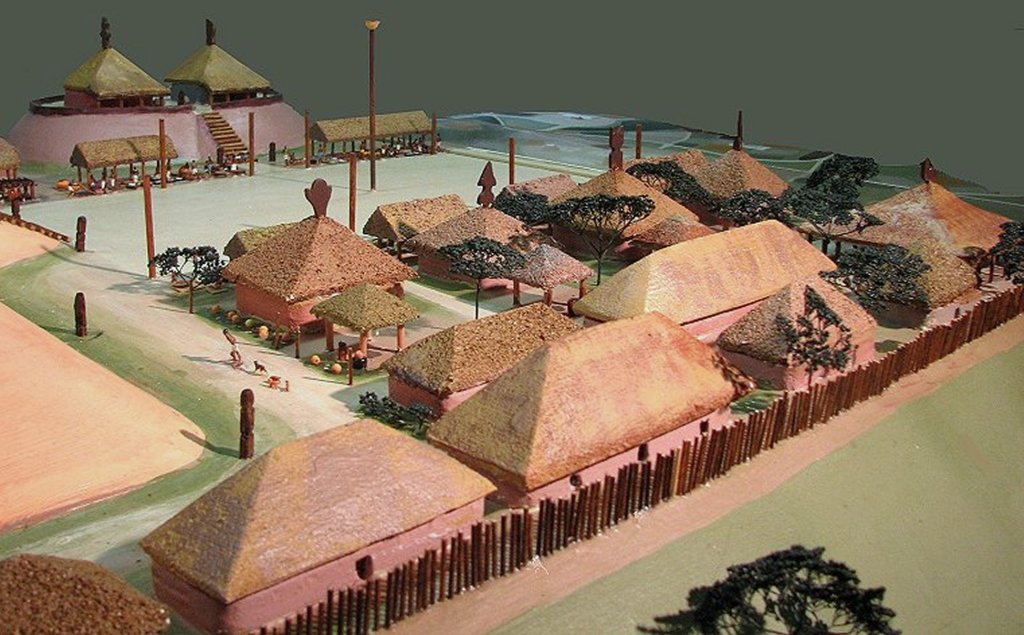
2008 ~ Ocmulgee Acropolis Model
This model was constructed for the Muscogee-Creek Nation in Ocmulgee, Oklahoma. I used the same techniques as the Etowah Mounds model, which was built the previous year. The field journals and site sketches of archaeologists were interpolated with state-of-the-art infrared imagery. This technique worked beautifully at Etowah Mounds, but not so well at Ocmulgee. Whereas the streets, blocks and courtyards were very visible at Etowah, Ocmulgee had contradicting patterns that looked like different town plans stacked on top of each other. It would take geo-magnetic sensing to solve this riddle.
Meanwhile, I tried as best as I could to match Dr. Arthur Kelly’s field notes with what I saw on the infrared scans. In many areas the infrared scans were useless. What I didn’t know was that Kelly had interpreted the upper layer of round building footprints as being from the Woodland Period. The archaeologists who actually designed the exhibits at the Ocmulgee Museum ignored Kelly’s observations of round buildings and instead told visitors that the town had rectangular houses from day one.

2012 ~ Daniel Bigman’s dissertation at the University of Georgia
Bigman bit off a huge project for his PhD dissertation. He used geo-magnetic sensing devices (underground radar) to survey most of the core area of Ocmulgee. If this was not enough, he also analyzed potsherds from areas around several of the mounds at Ocmulgee. Many of the potsherds had been stored in boxes since the 1930s.
To read the entire dissertation, go online to: https://getd.libs.uga.edu/pdfs/bigman_daniel_p_201212_phd.pdf
To access Dr. Daniel Bigman’s professional website, go online to: https://www.bigmangeo.com/
The media articles about Bigman’s study of Ocmulgee emphasized his use of geo-magnetic sensing devices. They provided extremely important information about the architecture and site planning at Ocmulgee. In practice, though, the fascinating data was under-utilized. A LIDAR scan (which Bigman could not afford) should have accompanied the surface survey. What was missing on his dissertation committee was a specialist in geospatial analysis at large indigenous town sites. It was one thing to use ground radar in a 19th century cemetery; an entirely different matter to apply to a large, 1000 year old town. Nevertheless, the data retrieved was fascinating and conflicted somewhat with prevailing understanding about Ocmulgee.
In practice, Bigman was pushed by the faculty committee to concentrate on analysis of potsherds. Much of his dissertation focuses on the potsherds. The problem is that the excavations at Ocmulgee involved large numbers of WPA laborers and very young archaeologists. Bigman had no clue exactly where these potsherds were found, only general areas. He had no way of knowing if the surviving potsherds were representative of what was actually in the ground.
It is a well known fact that the best artifacts, unearthed at Ocmulgee went out the gate under the overcoats of workmen to be sold to private collectors. The most amazing discovery at Ocmulgee, several hundred 2-3 feet (.67 – 1 m) diameter Maya style salt brine drying trays have never been put on display, because archaeologists, who focused on the Southeastern United States didn’t know what they were. Bigman was able to safely say that (1) Unlike the impression given by museum exhibits, there were several styles of pottery produced at Ocmulgee; (2) specific styles of pottery were associated with specific neighborhoods; and (3) the styles of pottery produced at specific neighborhoods shifted over time.
Oh there is one other thing. Bigman mentioned that the pottery found at the village on Browns Mount, about 10 miles south of the acropolis, (and only that location) had owls on the sides of the bowls. Owls? That’s the style of pottery was produced by the primitive, non-Arawak, Guanahatabey People of western Cuba. What the heck? The Guanahatabey and their almost as primitive, Ciboney Arawak neighbors, were the favorite sources of slaves for the Mayas. These hunter-gatherer peoples were overwhelmed by the boat passage across the Yucatan Channel and sudden exposure to Maya Civilization.
Surprising architectural discoveries
The dissertation under-analyzed the geo-magnetic data. There was no neighborhood or town-wide plan produced from the data as was created at Etowah Mounds between 2005 and 2007. Bigman described verbally the patterns that he saw on ground radar printouts, but this approach lacks the precision of architectural drawings. There was no way of knowing if his interpretation was accurate. He is not an architect and there were no architects or city planners on his dissertation committee.
Geomagnetic printouts of small clusters of buildings or individual structures did solve the riddle that had confused me when analyzing infrared images. Yes, indeed, over time the arrangements and architectural styles of structures built at Ocmulgee changed.
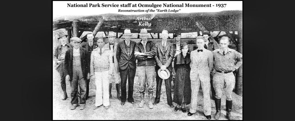
There was a radical change in Ocmulgee, just after 1000 AD. For those of you who don’t know, that period was when the Track Rock Terrace Complex was constructed in the mountain and the round structure that Georgia archaeologists call, “the Ocmulgee earth lodge” was built. It was not an earth lodge. It was a chokopa in Itsate or a chukofa in Oklahoma Mvskoke . . . basically a super-sized teepee.
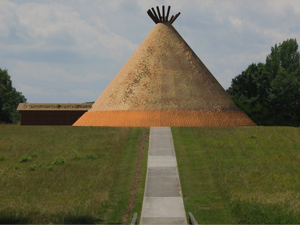
An earth covered building would be totally impractical in the Southeast, because of the constant rains and high humidity. The Creek Indians did not build earth lodges. However, no matter how much the Creeks complain to the Georgia archaeologists and even show them accurate drawings of cone shaped communal buildings, drawn by William Bartram, the UGA professors pout their lips, cross their arms, look askance and announce that their professors called these structures earth lodges and therefore, they are earth lodges . . . despite what the people whose ancestors built these structures, say.
This problem is related to a bigger problem that has developed in academic anthropology over the past three decades. Professional papers frequently cite the speculations of authority figures as “scientific facts.” Bigman’s dissertation is filled with such citations. They can be accurate. They can be inaccurate, but harmless, because no one cares what the academician said . . . or these speculations can be extremely dangerous, if interpolated as a stack of facts, when they are actually speculations made outside the realm of the archaeologist’s expertise. Because he didn’t know diddlysquat about the three Creek languages and didn’t know how to pronounce Spanish, archaeologist Charles Hudson made many inaccurate speculations that are now taught as facts to young anthropology students. There are many more examples within the body of professional literature. A geo-magnetic scan is a fact. A speculation is not a fact.
And now for the shocker at Ocmulgee.
Bigman only briefly discussed something that was a complete shock to me. Fortunately, he did provide a geo-magnetic printout to back up his statement. For the first hundred years of Ocmulgee’s existence, the houses were round. All previous archaeological reports on Ocmulgee said that from 900 AD onward the houses were rectangular and of post-ditch construction. Not only were these houses round, but they had center posts for support and they were relatively large.
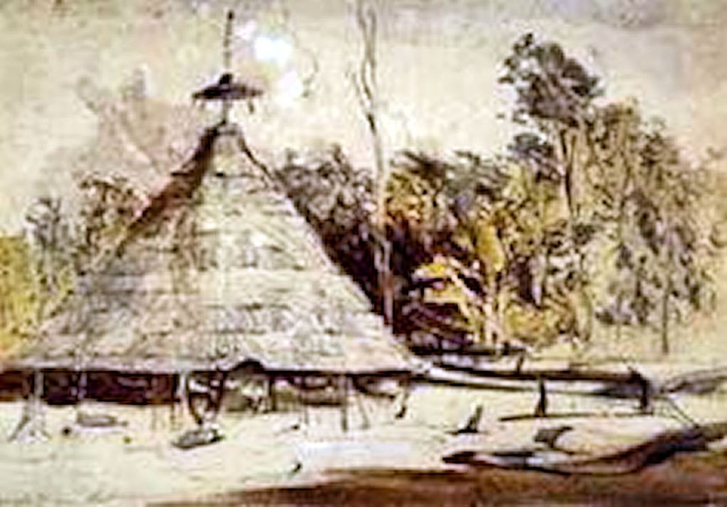
Pre-Mississippian Period round houses in the Southeast had stout posts in the thick exterior walls for supporting the roofs and a hearth in the center. Below is a photo of Dr. Arthur Kelly standing near a typical Woodland Period round house near Atlanta. The photo was taking from on top of a modest mound at site 9FU14.
Large round houses with center posts for extended families are a northern South American and Caribbean tradition! In Cuba, thhey were associated with the primitive Guanahatabey and Ciboney Peoples, plus some of the less advanced Taino Arawaks. However, in northern Venezuela, Colombia and Suriname, they were utilized by the most advanced indigenous cultures. What was this style architecture doing at Ocmulgee in 900 AD?
After 1000 AD the residential architecture quickly shifted to rectangular houses. However, there were two styles of rectangular house. In the elite neighborhood on the acropolis were now large rectangular, post-ditch houses that were typical of the Puntun and Itza Maya middle class merchants in southern Mexico. Out in the less affluent suburbs of Ocmulgee were smaller houses with central posts. That’s the style of house built by the Taino Arawaks in eastern Cuba, Haiti and Puerto Rico. Only in later levels did Bigman find a preponderance of rectangular post ditch houses in the suburbs.
Changes in residential architecture were accompanied by changes in the site plans of neighborhoods. Over time, the houses changed from being semi-circular clusters to circular clusters focused on mounds and plazas to houses formally sited on blocks and courtyards. The blocks and courtyards are associated with the direct ancestors of the Creek Indians. There were obviously many ethnic infusions and inter-regional cultural influences on Ocmulgee during the 250 years that its acropolis developed.
Yes, the Ocmulgee Museum needs to revamp its exhibits, but the National Park Service better create these exhibits in a manner, where they can be easily changed again. Suddenly, we know very little about this great megapolis on the Ocmulgee River. Take away the ridiculous Spanish galleon at the movie’s end and Holywood’s Apocalypto, is looking more and more like a PBS documentary.

words come so short in describing the excitement this and other articles of your research thrill my heart and cause me to re-evaluate what little I do believe of academia’ pseudo information.
truly thankful for all your report.
LikeLiked by 1 person
I am impressed by this article and the illustrations. I am putting together a video for YouTube on the Ocmulgee Mounds, focusing on yaupon and its broader history, and I was hoping you (Richard L. Thornton) might lend me the cover image, the Ocmulgee Acropolis Model, and the image of the Ichese model. They would be a great help. You would be given credit on the images. Thank you. Christopher Hall
LikeLiked by 1 person
Chris, could you please contact me at ApalacheResearch@aol.com, so we may discuss your request?
LikeLike
Mr. Thornton we have spoken before back around 2018-2019. I’ve recently found so.e things on lidar in Chattahoochee co. that I would like you to look at. Also there is a village in muscogee co that has a rezoning project in plan that will destroy the site. I contacted chief McCormick about it but thought you may be interested
LikeLike