by Richard L. Thornton, Architect & City Planner
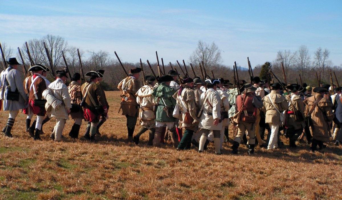
The Battle of Etowah Cliffs (Hightower) was fought on October 17, 1793 on the west side of the Etowah River, immediately south of its confluence with the Oostanaula River. The battlefield overlooks present day Rome, GA. The battle was part of the Northwest Georgia Campaign of the Southwest Territorial Militia, against hostile Lower Cherokees and Upper Creeks, which essentially ended the Chickamauga War in Alabama and Georgia. It was the last pitched battle between the Lower Cherokee under John Watts and militia forces until the Nickajack Expedition in September 1794.
Location: Latitude – 34°15’01″N ~ Longitude – 85°10’42″W


The articles about this battle in online references have been modified so many times by self-styled Cherokee-files, they can only be described as a mixture of partial history and false history. For example, they describe the battle as being fought at the great, ancient Cherokee town of Etalwayi. They add the Yi at the end to show that they know something about the Cherokee language. They state that the Cherokees were defending their ancestral lands where they had lived for 10,000 years. Actually, the Cherokees were secretly given Northwest Georgia as a hunting territory in 1785, but their Upper Creek allies, who legally owned the land, didn’t know that. Many Upper Creeks and Chickasaws, who WERE defending the lands of their ancestors, died in the battle along with the Cherokees.
The Wiki scholars have also virtually deleted most articles having to do with the Cherokee alliance with Great Britain and brutal attacks on the Carolina frontier in 1776. Whenever an article in Wikipedia is changed, online versions of other references, such as Encyclopedia Britannica, automatically change their verbiage, without fact-checking.
Worse still, the predominantly Tennessean academicians, who write about the battle in university-published books and papers, think that the battle was fought at Etowah Mounds, because “Etowah is an ancient Cherokee word, whose meaning has been lost.” Georgia academicians refuse to write about the battle because they suspect that it might have something to do with the Mayas. They were told by their department heads not to write about the Mayas because the Mayas are dangerous and un-scientific, plus they know for a fact that Maya refugees did not settle in Georgia.
The author lived in the center of this battlefield from December 1998 to June 2000, while planning a large downtown revitalization project in Rome.
Etymology: Etowah is the Anglicization of the Cherokee-nized word, Etawah, which is a place name derived from the Muskogee Creek word Etalwa, which means “Principal Town.” Etalwa is derived from the Itsate-Creek word, Itula, means the same thing both in Creek and its original source, Itza Maya. So the Georgia academicians are correct, they really shouldn’t mention the word Etowah in any articles, if they wish to maintain their current lack of credibility.
This battle was originally known as the Battle of Etowah Cliffs because Brig. Gen. John Sevier described the combat as Southwest Territorial militiamen assaulting the cliffs overlooking the Etowah River. During the 19th century, Rome residents typically called it the Battle of Myrtle Hill, because they assumed that the Myrtle Hill cemetery was the sole location of combat. Many illiterate frontiersmen mispronounced the word Etowah as Hightower. A 2016 revision of the Wikipedia article on this battle, inserted a Cherokee-centric description of the battle and deleted all references to Etowah Cliffs. It labeled the article, “The Battle of Hightower.”

The Line of Battle
The commander of approximately 800 mounted riflemen of the Southwest Territorial Militia was Brigadier General John Sevier. Tennessee did not exist at that time. The commander of the combined hostile Cherokees, Upper Creeks and Chickasaws was Kingfisher. He died in the battle.
Yes, that is the same Kingfisher, who was supposedly the husband of Nancy Ward and who, according to the outdoor drama, “Unto These Hills,” died in the never-happened Battle of Taliwa in 1754. Nancy Ward was probably born in 1754.
Several Cherokee men, who would later become some of the most important leaders of the Cherokee Nation in the early 1800s were at Etowah Cliffs. They included Nunnehidihi (Major Ridge), Uwatie, Charles Hicks, David Hicks, James Vann and Sequoyah. Nunnehidihi was an ethnic Natchez, descended from Natchez refugees, who had been allowed to settle in the Cherokee Nation in 1831. The other half of the Natchez Refugees settled in Pine Log, Georgia, which was in the Creek Nation until after 1785.
Casualties
There are many different statements concerning casualties in this battle. The most common statement is that very few militiamen were killed, but that several hundred Chickamaugas, mostly non-combatants (elderly, women and children), were killed. The number of Native American casualties probably was in the range of 700-800, not 1,000 as recently revised in Wikipedia.
Extent of the battlefield
Contemporary accounts by writers, who probably have never even been on the battlefield, place the battlefield on Myrtle Hill, which overlooks the confluence of the Etowah and Oostanaula Rivers. This is because skeletons were found at the base of Myrtle Hill by early white settlers, which were assumed to be those of fallen Chickamaugas. However, these skeletons were from burials associated with a Creek town located across the river in what is now Downtown Rome. When Rome was settled, there were several large mounds near the rivers. Their soil was used as landfill.
The “Last Stand” of some Chickamaugas may have been on the slopes of Myrtle Hill, but the account of the battle by Brigadier General Sevier suggests that the Native American families were camped, where Silver Creek joins the Etowah River. The Chickamauga sharpshooters were stretched for a considerable ways atop the cliffs overlooking the river.
Sevier did not mention the word, Myrtle Hill, because it would not exist for several decades. He merely said that the musket fire from the Chickamaugas atop the steep cliffs overlooking the river, made it impossible for his soldiers to cross the river. Most of the force then shifted out of sight and “crossed about a mile downstream from the Indian camp,” according to Sevier. There were some Cherokees guarding this ford, but they were greatly outnumbered.
The mouth of Silver Creek is about a mile downstream from the ford. There was no potable water on Myrtle Hill or the top of Etowah Cliffs. So the only practical place for families to camp was along Silver Creek. If the non-combatants were camped along Silver Creek, they would have been the next body of Chickamaugas to bear the wrath of the angry militiamen.
Origins of the Chickamauga War
This battle was a climatic event in a war that actually began in 1776. Self-styled Cherokee historians describe the war as beginning in the late 1780s in response to the illegal settlement of white families on Cherokee land, but extreme animosity between the Overhill Cherokees and white frontiersmen began early in the American Revolution. Killings and atrocities by both sides merely caused the other side to seek revenge. This animosity really didn’t end until most Cherokees were relocated from Tennessee to Northwest Georgia. Nowadays many Tennesseans proudly brag that they carry a trace of Cherokee heritage.
At the onset of the American Revolution, the British government pressured the Cherokees into becoming their allies against the rebelling 13 colonies. The Cherokees were only supposed to fight Patriot armies and militias, but instead swept into frontier settlements of Northeast Tennessee and the Carolinas without warning. Many whites, who were not involved in the rebellion, were killed. As a result the frontier went from being ambivalent toward the Revolution to becoming fire-breathing Patriots, who believed all Cherokees, regardless of age or gender, should be killed. In recent years, the history of this war has been almost completely edited out of online references such as Wikipedia.
The following year a Patriot invasion of the Cherokee country caused catastrophic losses among the Cherokees. The elected leadership quickly surrendered. However, a minority faction believed that the Cherokees should keep on fighting. They were expelled from the boundaries of the Cherokee Nation. Most settled farther west in Tennessee or among the Chickamauga- Chickasaws near Lookout Mountain. At least two small bands were allowed by the Upper Creeks to move into Northwest Georgia. The renegade bands in NW Georgia and NE Alabama continued the war with the Patriots by raiding frontier farmsteads. These acts made the frontiersmen hate all the Cherokees even more.
After Great Britain and the United States signed a peace treaty, the renegade Chickamaugas continued their war against the white settlers. The attacks were against small groups of travelers or family farmsteads. The victims were killed in particularly gruesome manners. This further fanned the hatred against all Cherokees.
There is a misconception that the Treaty of Hopewell at Col. Andrew Pickens plantation in December 1783 was between the Cherokee Nation, Creek Nation and United States. It was not. The only legitimate signatories were representatives of the Elate, an independent confederacy of 12 village . . . predominantly Hitchiti-Creek, Natchez and Uchee in northeast Georgia that also included two renegade Cherokee bands. They were being allowed to live on lands belonging to the Upper Creek branch of the Creek Confederacy. Nevertheless, Congress declared the treaty fraudulent because only representatives of Congress could negotiate treaties with Indian tribes. The Hopewell Treaty was signed by members of the South Carolina and Georgia militia! In the Hopewell Treaty, the Elate ceded all Creek lands in Northeast Georgia to Georgia and in return the white commissioners set the boundary between the Cherokee Nation and the Elate as being the Georgia-North Carolina State Line.
A conference, sponsored by Congress was held in Augusta, GA the following spring 1785, which did include legal representatives of the Cherokee Nation and Creek Confederacy. Since their lands east of the Oconee River had already filled with settlers, the Creeks grudgingly ceded them. However, they thought that they kept all lands west of the Oconee.
In a separate, secret treaty with the Cherokee Nation, the United States commissioners, who were from Georgia and the Carolinas, gave Creek lands west of the Chattahoochee River to the Cherokees as hunting territory. This left the Creeks with a narrow corridor of land between the Chattahoochee and Oconee that extended northward to present day Clarkesville, GA. It was hoped that this would stop the Chickamauga War. It did not. Creek leaders did not find out about the secret clauses of the Cherokee treaty until 1790 then immediately declared war on the State of Georgia . . . who they thought were responsible for the secret treaty.
Edited out of most online references these days that also in 1786, the hostile faction of the Cherokees joined the Northwest Confederacy formed by Mohawk leader, Joseph Brant. The Chickamauga Cherokees participated in several massacres of white settlers in the Midwest and were at the Native American victory in the Battle of Fallen Timbers.
The Cherokees were not formerly given Northwest and North Central Georgia as a place to settle until the ratification of the Treaty of Philadelphia in 1794. At this time, the United States government secretly signed an agreement with the State of Georgia, in which it promised to remove the Cherokees to the new Alabama Territory within 10 years.
The Creek Confederacy did not acquiesce to the land theft until 1796. The Creeks were promised a vast province in Alabama, plus all their remaining lands in Georgia for all time, in return for ceasing claims to North Georgia. The various myths about the Cherokees winning all of North Georgia in a war before the American Revolution were created in the late 1820s by the editor of the Cherokee Phoenix newspaper, Elias Boudinot.

Expansion of Chickamauga War
With the approval of President George Washington, an attempt was made to negotiate a new treaty in the Southwest Territory (now the State of Tennessee), but the meeting place was raided by a party of militiamen. John Sevier secretly ordered Captain John Beard to attack the Cherokees, who were attending the treaty conference. Many Cherokee were killed. President Washington ordered the arrest and trial of Beard, but John Sevier helped him escape to avoid trial. Local authorities, who generally wanted the Cherokees out of Tennessee made only token efforts to bring Beard to justice.
In retaliation, John Watts first signed a treaty with Spain in 1792 to obtain muskets and munitions then led a war party of over 1,000 Chickamauga Cherokee and Upper Creeks in a series of attacks against settlements that he and his followers considered to be Cherokee or Creek lands, since their faction had not approved the treaty cessions.
The Upper Creeks and Chickasaws claimed central Tennessee, because their ancestors had lived there for many centuries. It should be emphasized that the majority of Creeks were not involved in the hostilities of the Chickamauga War and in fact, furnished soldiers to fight the renegade Cherokees and Upper Creeks. Muskogee and Hitchiti Creeks in Georgia were intermarrying with white families and maintained lifestyles, little different than their white neighbors.
The Cherokees were particularly enraged when white settlers then moved farther south into definite Cherokee territory and established hamlets in the vicinity of present day Knoxville. This was a clear case of treaty violation.
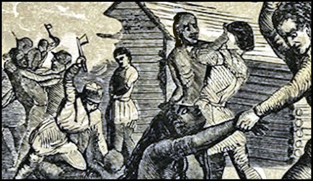
While headed to White’s Fort, which is now Knoxville, the Cherokees and Upper Creek hostiles eventually decided that they t would launch an attack on Cavett’s Station on September 25, 1793.. At the time, only Alexander Cavett, two unrelated men and Cavett’s family (totaling 13 people in all) were present at the fort. Cavett and the other two men were reportedly the only competent marksmen. The Cavetts, apparently put up a fierce resistance, killing or wounding at least five warriors from the Cherokee attackers.
The Cherokee attackers pulled back and for a parley. It was agreed that if the settlers were to give up resistance and lay down their weapons, their lives would be spared. They would be exchanged for a like number of Cherokee held prisoner by local militia.
The settlers agreed, but as soon as they exited the fort, Doublehead and his warriors broke their agreement and attacked the prisoners, brutally murdering every man, woman and child. John Watts attempted to spare one small child from the stockade, but Doublehead himself leaped upon the boy and split the child’s skull with a tomahawk.
Due to his reputation for fierceness, Doublehead had previously been nicknamed “man-killer” by his warriors. However, as a mark of derision for his actions at Cavett’s Station, Watts would henceforth refer to Doublehead as “baby-killer” for the remainder of his life.
According to a later witness of the scene, the murdered family members were horribly mutilated and their bodies strewn about the area. However, their tragic deaths were not in vain. The unexpected resistance of the little group at the fort had so delayed the main Cherokee force and sown further division among their ranks that the imminent attack upon Knoxville was summarily abandoned; quite possibly saving the town from being completely wiped out
At this point, the lives of all Cherokees in Tennessee, whether hostiles or not, became in danger. Whites were killing any Indians they saw. Cherokees, who had attempted to stay out of the fighting, became hostiles after one or more of their family members had been killed by militiamen or settlers, who happened to see a Cherokee walking down a road. Revenge begot revenge.
Northwest Georgia campaign
After the 1786 Treaty of Augusta, more and more bands of Cherokees began moving southward into remote mountain valleys in Georgia to escape the raids of irate white settlers in what is now Tennessee. Although the Upper Creeks thought that they still owned the land, they did not object because many Upper Creeks in what is now northern Alabama were allies of the Chickamauga Cherokees. Chickamauga Cherokee villages would typically stay at one location to plant crops for a year or two then move on. Their warriors used the hidden locations as bases for making hit and run attacks against small parties of whites. It was primarily Upper Creeks, who attacked settlements in Northeast Georgia. The Hitchiti Creek allies of the United States were just a common a target as white settlements.
Word of the massacres spread quickly. John Sevier raised a force to permanently wipe out the Chickamauga Cherokee villages in North Georgia and Kentucky. The Cherokee force split up with some heading toward Kentucky and some toward North Carolina, but most headed toward Georgia.
Sevier’s men killed most of the Cherokees they encountered. Many of their atrocities have been forgotten by history. However, there are vague cultural memories of the massacre of a Cherokee village on Bear Creek in western Gilmer County (Ellijay). Most of the adult men were gone . . . the women told the militiamen that they were hunting . . . but the Tennesseans did not believe them and preceded to murder the non-combatants.
The army then moved westward and attacked about 800 Cherokees, Upper Creeks and Chickasaws on the west side of the Etowah River, overlooking what is now Downtown Rome, GA. The Chickamaugas knew that the white soldiers were approaching and so posted groups of men along principal approaches to their camp site.
Sevier wrote an account of the battle. The Etowah, Oostanaula and Coosa Rivers are far too deep at Downtown Rome to wade across. The militiamen initially tried to cross in canoes and rafts, but found the fire from the concealed Native American soldiers at the cliff tops.
Sevier then ordered the majority of his me to march about a mile southeast of the main Chickamauga defenses, where there were shoals and shallow water. The ford was defended by a body of Chickamaugas, but they were grossly outnumbered by the attackers. The Cherokees rushed to contest the crossing of the Etowah, but failed. The guards of this ford had already been beaten back and the main body of the attackers was now on the opposite side of the river.
The militiamen soon overtook the retreating Chickmaugas and came upon non-combatants. Traditionally, it was said that they massacred the women and elderly there, but this story has been deleted from contemporary texts. When Kingfisher was killed, the remaining warriors fled. Gen. Sevier ordered the village to be burned.

Aftermath
Nunnehidihi led his friends, Charles Hicks, David Hicks, James Vann, Uwatie and Sequoyah to his sister’s village at Pine Log, Georgia. It was the location of the portion of the Natchez refugees, who settled among the Creeks, but now was in Cherokee Territory. They remained in Pine Log until around 1798.
With the surviving Chickamaugas scattered, Sevier’s army marched southwestward down the Coosa River, destroying Upper Creek villages before returning to the Knoxville area. The “Battle of Etowah Cliffs” was Sevier’s last battle against Native Americans.

Environmental Features
Geographical Location: The battlefield and archaeological zone is located on the west side of the Etowah River across from Downtown Rome, GA.
Owner/Historical Status: Myrtle Hill and the street system is owned by the City of Rome, GA. The remainder of the properties are privately owned. Visitors can access the entire battlefield via sidewalks. Much of the battlefield is in a National Historic District or else a permanent Natural Buffer Zone for the Etowah River.
Geology/Ecology: The site is in the Great Appalachian Valley of the Ridge and Valley Province. Most of the village site is at an elevation ranging from 600 ft. to 550 ft. above sea level. It is underlain by sedimentary rock, mostly mudstone and sandstone at this location. Limestone and shale strata occur away from the river at higher elevations. The ridges are typically capped with sandstone.
The region along the tributaries of the Lower Etowah River contains mature Southern Appalachian forests with some of the greatest plant diversity in the world. There are also hemlocks growing along the streams and several varieties of pines at drier elevations. Until the late 1930s about half of the mature trees were American chestnut trees, which produced a bounty of food for large game animals and humans. These are now all extinct because of a pathogenic fungus that originated in Europe.
Climate: The location receives at least 52 inches of precipitation a year. The flood plain of the Coosa River runs between 400 and 500 feet lower in elevation than much of Metro Atlanta, but is farther north and adjacent to mountains. This results in a somewhat different climate. Winter temperatures vary, but can frequently be below freezing. The Rome, GA area tends to be slightly colder than the Atlanta Area in the winter and slightly warmer and more humid than Atlanta in the summer. In the past, the area received extensive snowfall, but in recent decades the depth and number of snowstorms have declined considerably. Snowfalls deep enough to hinder traffic usually occur only once or twice a winter . . . sometimes not at all.
Cultural Periods: Early Federal Period
Ethnic Affinity: This village site was briefly occupied by a combined force of Cherokee, Upper Creek and Chickasaw Indians in 1793. .
Archaeological Investigations: None
