
by Richard L. Thornton, Architect & City Planner
For over two centuries a carved block of volcanic stone has been on display at Travelers Rest, a frontier inn that is now a Georgia State Historic Site. Except for a brief visit by an archaeologist in the late twentieth century, it has consistently been ignored by the archaeology profession. It garnered an extremely brief mention in a booklet on the archaeology of Northeast Georgia, published by the the University of Georgia’s Department of Anthropology. A UGA professor inscribed it as “some form of Cherokee writing.” Well . . . no . . . it is actually one of the most important Pre-Columbian artifacts in North America. Unlike controversial stone carvings as the Kensington Stone in Minnesota, there is absolutely no doubt of its authenticity.
Etymology of Tugaloo
Tugaloo is NOT an ancient Cherokee word that means “a place in the forks of a stream” as Wikipedia tells you or “tumbling waters,” as stated in a local tourist brochure. It is the Anglicization of Tagalu, which is the Cherokee-nization of the Creek word, Tokah-le, which means “freckled or spotted people” nowadays in Muskogee. Actually, the Creeks roll their R’s so hard that White folks generally wrote them as L’s. The Creek’s word is derived from the Archaic Gaelic ethnic name, Togha-re or earlier, Togha-reigh . . . which means “Great, Best or Principal People.” They were the elite of Bronze Age Ireland and Scotland . . . most likely also, southern Scandinavia.
Hate to bust the bubbles of all you folks in the northeast tip of Georgia, who claim to be 1/640th Cherokee, but can’t find any Native American DNA in your genes. Yes, Rabun and the northern halves of Stephens and Habersham Counties were in Cherokee territory from around 1717 to 1794, but there were very few, if any real Cherokees living there. It was Uchee, Sokee, Eastanolee-Chickasaw and Cusseta-Creek territory. As Georgia’s Indian Agent, the Rev. Charles Wesley visited Tugaloo and described as a village of about 100 Uchee. He stated that he never saw a Cherokee anywhere in the Colony of Georgia.
From the day in February 1733 that the first English colonists landed at Yamacraw Bluff on the Savannah River, the Uchee have consistently stated that their ancestors sailed across the Atlantic Ocean from the home of the sun . . . but no one believed them.

The history of Traveler’s Rest
Construction was begun on the inn in 1785 by Major Jesse Walton, shortly after the Cherokees ceded the remaining lands, they claimed south of the village of Tugaloo, in the 1784 Treaty of Augusta. Walton was a native of Virginia, but was living in North Carolina at the beginning of the American Revolution. He was Second Major in the 1776 punitive expedition into the North Carolina Mountains, led by Colonel William Christian, which burned every Cherokee village it entered and killed every Cherokee adult it saw.
After founding the first town in Tennessee, Jonesborough, Walton moved to Northeast Georgia in 1781. He constructed the original two-story log house, which became Travelers Rest, but was killed by Cherokees in 1789. Now you know why. Tourist brochures do not tell you the whole story!
The Walton family sold the land to James Rutherford Wyly, who built the main part of the house between 1816 and 1825. Wyly opened the house as an inn for travelers on the newly constructed Unicoi Turnpike. Devereaux Jarrett bought the house on August 21, 1838 and it became the headquarters of his 14,000-acre plantation. Jarrett added to the original structure and opened it to the public.
While gathering field stones for construction of a chimney around 1796, an employee or slave of the Waltons found a peculiar “marked stone” on a knoll next to the Tugaloo River. He brought it back to the house. Rather than using the stone in construction, the stone was laid on the ground, behind the house, to be used as a carriage step. It has pretty much lain in same location since then.
In 1955, Mary Jarrett White deeded the core property of Travelers Rest to the State of Georgia. It was restored and became a state historic site. In August 1977, Ed and Bobbie Smith used charcoal rubbed over tracing paper to copy the most visible features on what they called the Toccoa Rock. No forensic geological methods were utilized to obtain details of the engravings. The next week, Bobby Shaw converted their drawings into scaled sketches, which ultimately were printed on a laminated plastic sign, mounted next to the rock.
In the decades since then, several regional magazines, including Early Georgia, the publication of the Society for Georgia Archaeology, have carried articles on Traveler’s Rest. If the Tugaloo Stone is mentioned at all, the following brief statement is repeatedly replicated: “Near Traveler’s Rest is Tugaloo Island is the ancient Cherokee town of Tugaloo, the first Cherokee town in Georgia. Here around 1400 AD, Cherokees built eight large mounds with temples on top. Archaeologists believe that the engravings on the stone are an ancient Cherokee writing system.”
Actually, archaeologist Joseph Caldwell determined that the Proto-Creek town on Tugaloo Island began as a Deptford Culture village around 1000 BC. The earliest mound-building occurred between 200 AD and 800 AD by practitioners of the Swift Creek Culture. Serious mound building began around 800 AD. During the Late Mississippian Period, the occupants of the town had the same cultural traits as those living around Macon, GA – the Lamar Culture. The town was occupied by ancestors of the Creeks until at least 1700 AD, when the entire town was burned. A few years later a small village of crude round huts was built in one part of the town plaza, but the mounds were never used again. Caldwell never mentioned the Tugaloo Stone in his report.
In 2008, a gentleman from Ellijay, GA studied the Tugaloo Rock and made his own drawings, which looked quite different from those on the plastic sign. He connected lines together to create a Middle Eastern type of composition. The article he wrote about the stone claimed that it was an altar to the Canaanite god Baal.
Fast forward to February 2017
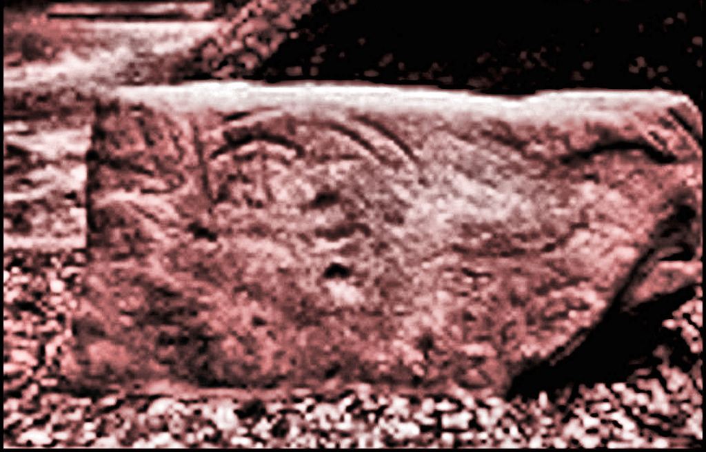
I glanced at the Tugaloo Stone’s explanation on the plastic acrylic sign. The lines just looked like gobbledygook and did not resemble any of the other petroglyphic in the Southern Highlands. With great difficulty, because the stone was laying on the ground in complete shade, I took some quick photos and went on my way.
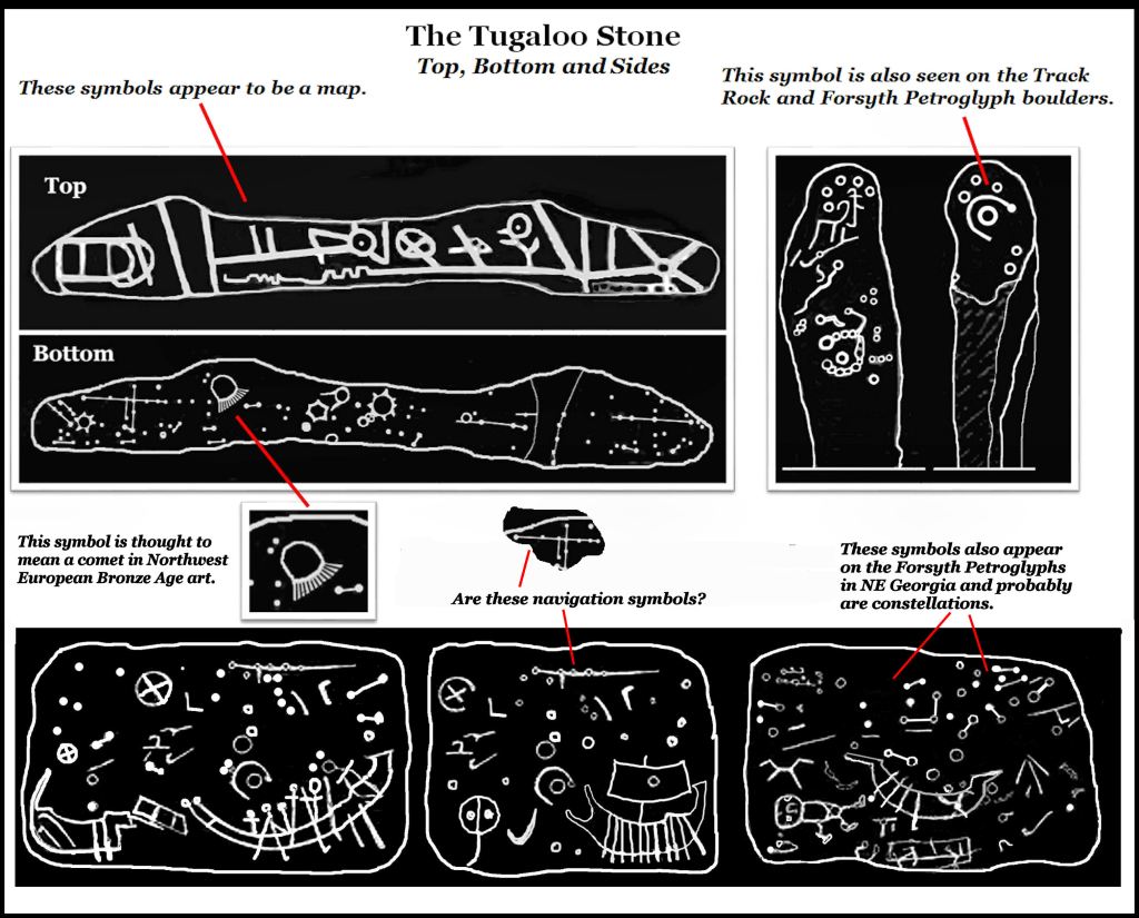
About a week later, I glanced at the photos of the rock and then enhanced them with the same software that I use to make ancient maps legible. Many details appeared, which the Smiths had missed with charcoal rubbing. I could now see several of the same glyphs that are on the Forsyth Petroglyphic Boulder, which was found on the Upper Etowah River. However, at the top of the rock on each side were strange parallel curving lines with many short perpendicular lines. They looked something like the plans for curved buildings. Out of curiosity, I did a 180-degree rotation command on the photo images.
Holy Agnetha Fältskog! I was looking straight at a Scandinavian Bronze Age hjörtspringerbåt! The other two ships looked like larger types of Bronze Age boats. Everything else on the rocks looked like standard Bronze Age astronomical and navigation symbols. Well, I better back track to when I was 23.
You see . . . the morning after I graduated from Georgia Tech, a Sunday, I started on a 24-hour journey by jet, bus and ferry to a city in southern Sweden, which was located in the heart of the Scandinavian Bronze Age civilization. I was going to start a dream job that I didn’t even apply for. Heck, I don’t even recall the Bronze Age being discussed during my previous 17 years of formal education and I was suddenly immersed in it. There were dozens of burial mounds around Landskrona that were constructed the same and built at the same time as the Woodland Period burial mounds in the Southeast and Ohio Valley. There was a conical burial mound on Ven Island with a ditch around it, which was identical to the Adena mounds in Ohio.
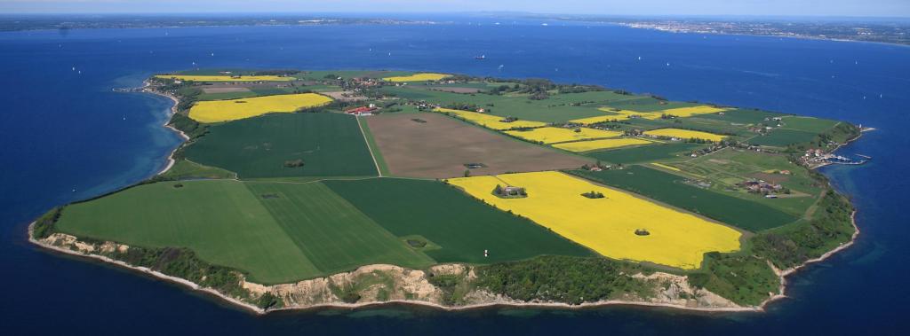

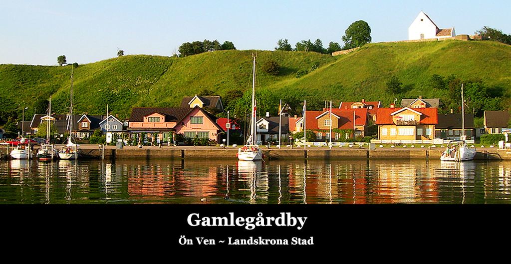
On third day of work . . . Wednesday, June 7, my boss Stadsarkitekt Gunnar Lydh, took me by boat to the planned construction site of a pedestrian village, which I was to design. Nearby was the oldest Christian church in Scandinavia, Sanct Ibbs Kyrka (c. 900 AD) which was built on top of an ancient “stone circle” Bronze Age shrine. Of course, in Georgia we originally had well over a hundred stone circle shrines, but they weren’t called Bronze Age sites. At the base of the cliff near the church were boulders engraved with Bronze Age glyphs.

We clambered down the grassy cliff to the boulders. I immediately noticed many Creek Indian sacred symbols. You can also see them at the Etowah Mounds Museum. What were they doing on an island in the Öresund Channel? This event has bothered me my entire life. I was also puzzled as to why the copper hatchets and ingots in the Landskrona Stads Museet identical to the copper hatchets and ingots in the Etowah Mounds Museum?
The petroglyphs were at the same location where we would later go skinny-dipping on dates, so those boulders became embedded imagery in my mind. I never knew why they would be so important.

Years later, the pedestrian village of Gamlagårdby is finished. I presume that the Bronze Age petroglyphs were moved to a safe location and that skinny dipping is no longer allowed. In 2018, a graduate student from Lund University emailed me a chart which translates many of the symbols on the Tugaloo Stone. Life is indeed a box of chocolates.


Yet another fascinating writing and learning much from your page. Thank you.
LikeLiked by 1 person
Richard, How did the same boat stone artwork find it’s way from Egypt to Sweden Or was it the other way around? The boat in Georgia has a symbol for copper not found in Sweden or Egypt…so the symbol of Copper was (a circle with a line) but a better “mountain copper” was another added line which became the symbol we use today. The Tokha had some people in Pre- bronze age Egypt (3114 B.C) but with a new kingdom started in Egypt they left there. The ancient cave script found in Kentucky seems to be connected to more than one people that built flat top Earth works: “Tokharian, who are known in Greek sources as Tókharoi, in Sanskrit as Tukhāra and in Chinese as Tuholo” http://www.lituanus.org/1974/74_3_01.htm
LikeLiked by 2 people
That actually is the Swedish Bronze Age symbol for gold I believe.
LikeLiked by 1 person