Origins of the Chickasaw and Creek Peoples – Part 17
by Richard L. Thornton, Architect and City Planner
In our article in this series on the Swift Creek Culture, readers learned that in 539 AD, a massive asteroid or comet struck the ocean at an obtuse angle off the coast of Cape Canaveral, FL. It obliterated the islands on the coast of northern Florida and sent a tsunami well over 100 feet (33 m) high over southeastern Georgia . . . completely wiping out the Swift Creek towns and villages below the Fall Line. The tsunami’s debris ridge is still up to 85 feet tall on the Georgia Coast. Suddenly, new Swift Creek villages appeared in the mountains of northern Georgia. Some lasted until around 1000 AD.
The impact was soon followed by massive volcanic eruptions in Central America, Central Mexico and Iceland, which drastically worsened the climate of the Northern Hemisphere. In our first video on the Mayas of Campeche, viewers learned that there was a out-migration of people from Eastern Campeche between 539 AD and 600 AD. Mexican anthropologists don’t know where they went.
Around 990 AD, the suburbs of Chichen Itza were almost abandoned as people, who liked to construct Toltec style architecture took control of the city. Mexican anthropologists don’t know where these “Common Folks” people went. Then in 1014 AD, a massive comet broke up over the North Atlantic Ocean, causing tsunamis on the coasts of North America and western Europe, which killed several hundred thousand people, living near the ocean or along estuaries. At least 30,000 people died along one estuary in southern England.
There was a third major out-migration from the Gulf Coast of Mexico between 1150 AD and 1250 AD. This was caused by the invasion of Chichimecas and other Nahua-speaking groups into the region. The invaders were fleeing a drought in what is now northern Mexico and the southwestern United States. These Nahuas had a nasty little tradition of liking the flavor of human flesh, cooked with vegetables in a stew!
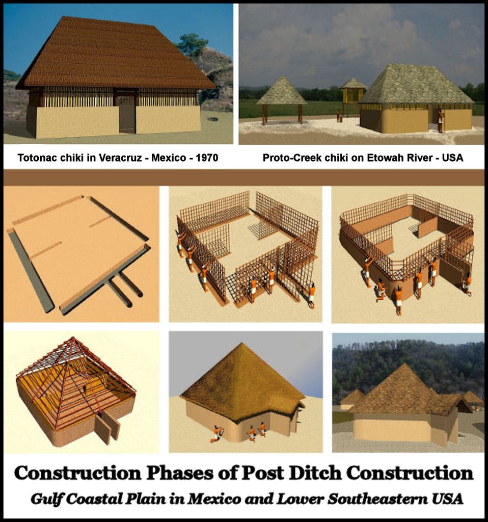
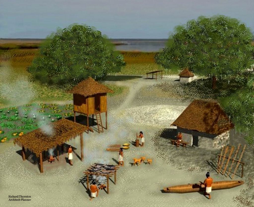
Radical changes in the architecture in the Chickasaw and Creek People’s homeland provide strong evidence of where these Mesoamerican refugees settled, after being driven out of their homelands. First of all, here are drawings that explain how the houses were built . . . both in Southern Mexico and in the Lower Southeastern United States.
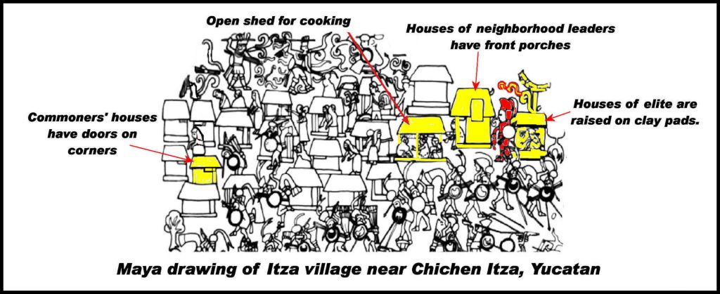
Almost all public art in Mexico is focused either on their gods or the elite. In a rare exception, a mural was created in Chichen Itza, which described an attack on a coastal town near Chichen Itza. The panel also displays the day-to-day lives of the residents – prior to the attack, the homes of the “regular folks” and their canoes.
The corner-door houses of Chichen Itza
(See architectural rendering of Etula and section of Chichen Itza Mural above) Between around 810 AD to 990 AD, the predominate style of house for the commoners in the suburbs of Chichen Itza was a square, wood framed, wattle & daub wall structure with a door in one corner. Within each neighborhood or suburban village was a different type of house. It was rectangular and had three rooms. Typically, one or two rooms had exit doors, which opened upon a covered porch. All houses had open sheds for kitchens. A few larger, rectangular houses were raised on clay pads, aka low mounds, which indicated their higher political status.
As was the case at what we call Ocmulgee National Historical Park, most of the commoners’ pottery was undecorated, shell-tempered redware. Shell-tempered redware required significantly less firewood to vitrify. White and beige clays with sand tempering required much higher firing temperatures and about four times longer firing. The introduction of the shell-tempering innovation in North America, began on the Gulf Coast then spread northward to Ocmulgee.
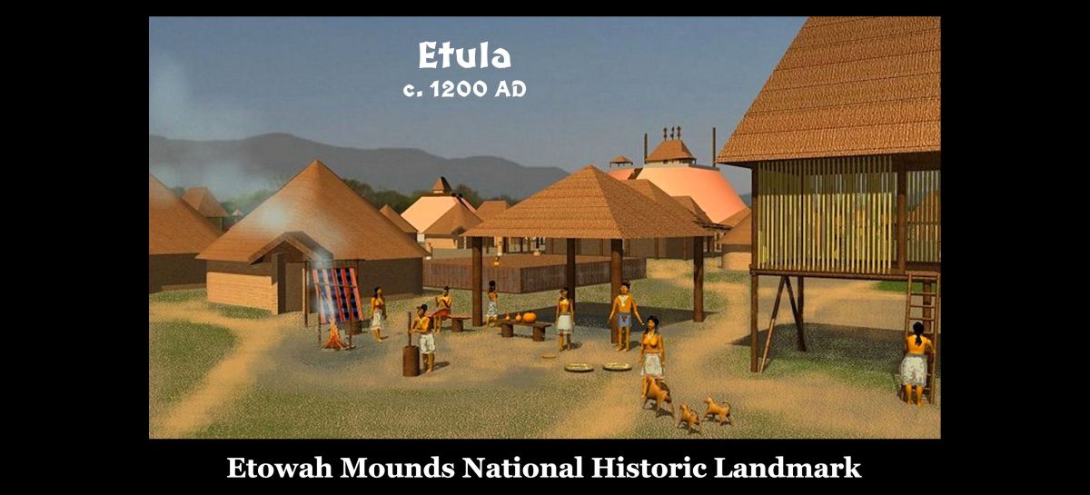
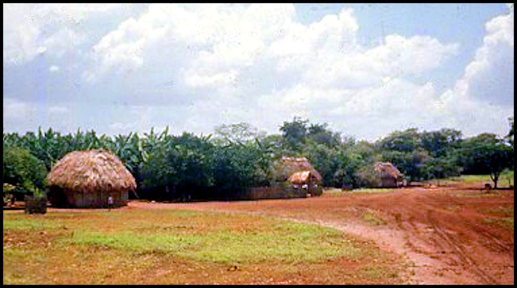
Around 1000 AD, the commoners at Chichen Itza began building more diverse styles of houses, with the corner door houses being replaced by styles more typical of Maya provinces elsewhere. Simultaneously, corner door houses appeared for the first time in Southeastern North America . . . specifically in Georgia . . . at the Lamar Village site on the Ocmulgee River, the Itzate Site in the Nacoochee Valley and Etula on the Etowah River.
A horrific storm around 1200 AD, flooded both the Lamar Village Site near Macon, GA and the Etowah Mounds Site in Cartersville, GA . . . 126 miles to the northwest. Both villages had been on the end of horseshoe bends in rivers. Afterward, both villages were on islands. Very few, if any, corner door houses were built at Etula (Etowah Mounds) after it was reoccupied. Instead other styles of houses, typical of southern Mexico, were constructed. These will be discussed later in the article.

Immediately after the cataclysm, corner door houses began appearing to the south of Etowah Mounds in Cobb, Paulding, Polk, Harrison, Fulton and Douglas Counties, Georgia. They also soon appeared at certain town sites on the Upper Tennessee River in Tennessee. In both regions, corner door houses remained a common form of architecture until the 1700s AD, and were associated with the tribes of the Tulasi (Tvlasi, Talassee) tribes, plus also, the Mouse Creek Culture. Tulasi means “descendants of Tula.”
Tula was the Totonac name for Teotihuacan, but came to mean “town” in the Totonac, Western Maya, Highland Maya and Itsate (Hitchiti) Creek languages. Tula was derived from the Maya word, tauli, which means “stacked rock construction.” The Maya, Choctaw, Chickasaw, Creek and Alabama languages all use the same word for “rock” – tali. Etula means “Principal Town” in Itza Maya, most Highland/Western Maya languages and Itsate Creek.
Chichen Itza neighborhood or village chief’s house
Whether in Southern Mexico or in the Muskogean regions of the Southeastern United States, these houses were always of timber-framed wattle and daub construction. They became the inspiration for the stone masonry houses of government officials and priests in the capitals of Classic Period city states.

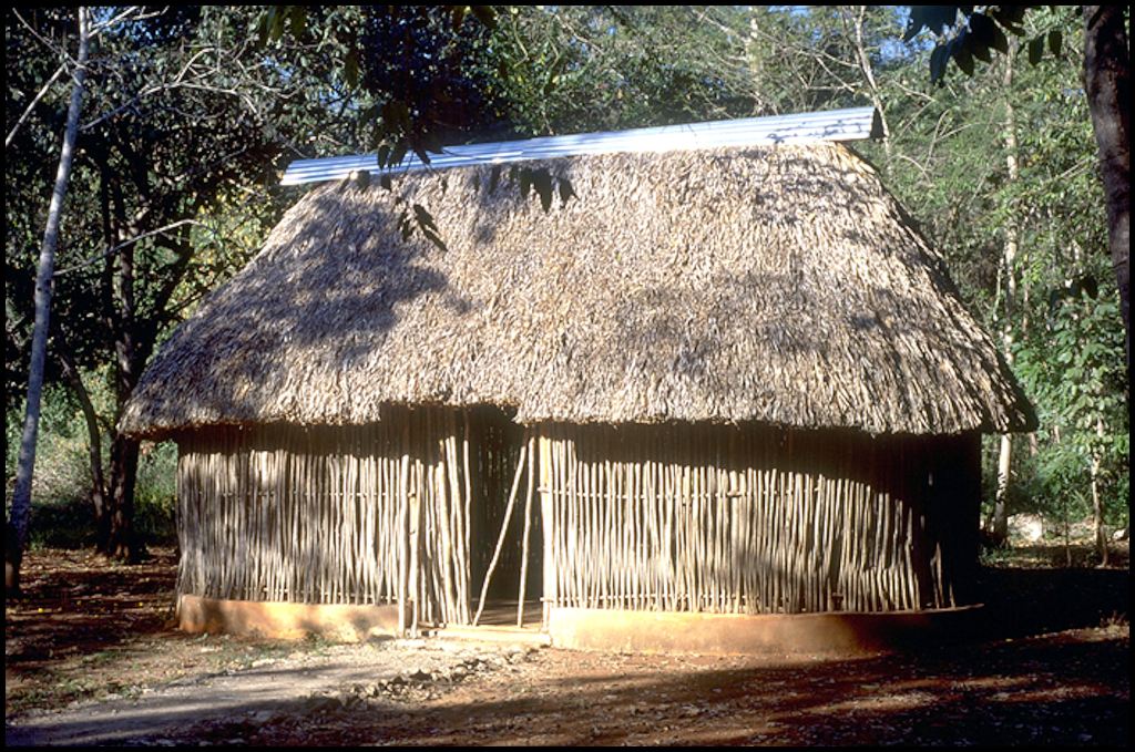
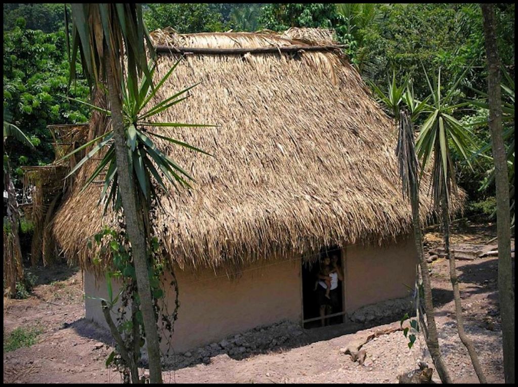
Puuc Maya and Chickasaw style houses
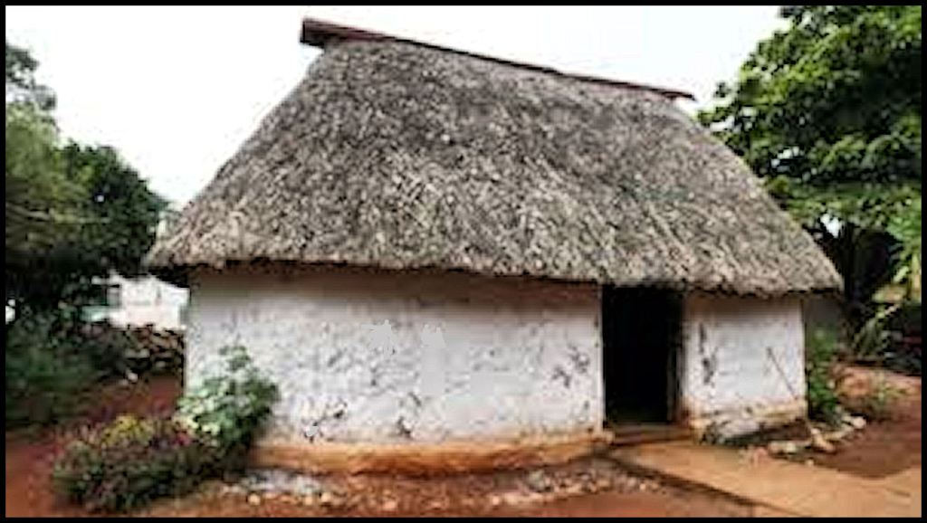
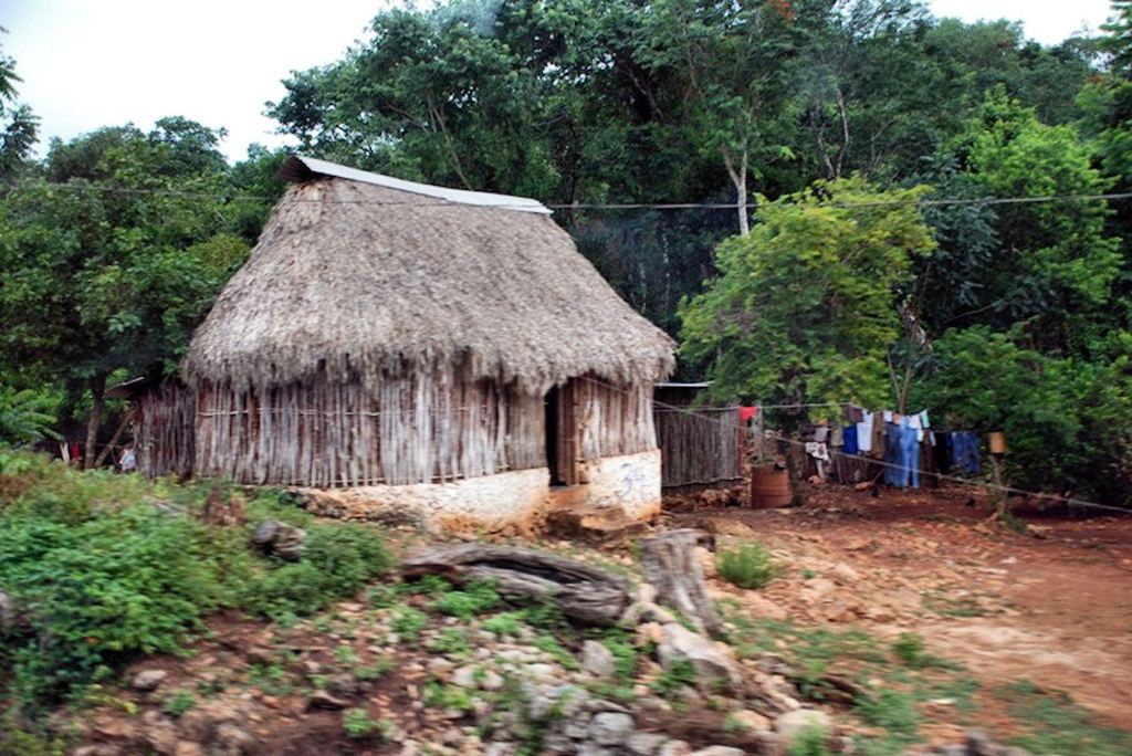
The Puuc Hills are located in eastern Campeche and western Quintana Roo States, Mexico. When I first visited the region in 1970, the predominate house live in by Maya families was an oval shaped structure 20-25 feet (6-7.6 m) by 10-15 feet (3-4.6 m) oval shaped huts. Still today, one can see such houses throughout both states, but they are steadily being replaced by concrete block houses with electricity and plumbing in urban areas.
I slept in two types of Puuc Maya houses. One has walls composed originally of wattle and daub, plastered with home-made lime white wash, but today is more commonly constructed of limestone rubble, plastered with a Portland cement base stucco. This winter house is called a choko (warm) or calli. Choko is also the word used for winter houses in the Choctaw, Chickasaw, Creek and Alabama languages.


As is explained in greater detail in the Part Two Video of my series on the “Mayas of Campeche,” my tour guide, Ana, and I made an amazing discovery after turning into what was basically a “Jeep trail.” It was the village of Xculoc. It’s layout seemed to have been unchanged in 1,400 years . . . or more. Although the government building (above) in Xculoc was drawn by architect Frederick Catherwood in 1839, the ruins had been subsequently forgotten. The name would not appear on any comprehensive list of Maya sites until 1980 . . . following an archaeological survey of the Puuc region of Campeche in 1979.
What was so special about Xculoc? It still retained most of its original architecture and village plan. Oval houses were constructed to form a large oval plaza, perhaps about 800 feet (244 m) long on the NE-SW axis. On the SW corner was a Roman Catholic chapel, constructed atop a low earthen platform, where a small temple has once stood.
The Xculoc that Ana and I visited so long ago is barely visible now. The oval plaza was barely visible in mid-2021. The town had been re-planned to a gridiron street pattern. Most of the old oval Maya houses are gone. The latest version of Google maps shows a new pre-engineered metal building in the center of the oval plaza. The sudden boom is being driven by a large Mennonite colony that was established in 2000 to the east of Xculoc.
To be honest, I had long forgotten that visit to Xculoc until the summer of 2021, when I was reading the journal that I kept while on the Barrett Fellowship in the summer of 1970 in preparation for creating three videos on Campeche. Then it dawned on me. Xculoc was exactly like an archaeological site in the Nacoochee Valley that I pass several times a week . . . the Eastwood Mounds and Village Site.
Nacoochee Valley, Georgia – 1939: A recent graduate of Harvard, who grew up in South Carolina, named Robert Wauchope was hired by the WPA to carry out a comprehensive archaeological survey of northern Georgia . . . with the help of locally hired laborers. Wauchope planned to spend about a week or two in the Nacoochee Valley. From surveys by pioneer archaeologists Charles C. Jones, Jr., Cyrus Thomas and George Gustav Heye, knew that there were “a couple of mounds in the valley.”
What he didn’t realize until walking the land was that the entire seven mile long valley had been filled with villages and towns for a long, long time. It has been continually occupied by humans since the last ice age. Unlike most occupation sites that archaeologists visit in North America, he found villages founded 2400 years ago, that remained almost continuously occupied until the end of the 17th century. Some villages were only separated by 100-200 feet of farm land. Wachope also encountered in the upper layers of soil, what he described as several truck loads of 16th or 17 century European artifacts, including tools and such weapons as arquebuses,
He spent much of his year alloted for all of North Georgia in the Nacoochee Valley. The Encyclopedia Britannica now describes the Nacoochee Valley as “the most densely occupied archaeological zone in North America.”


Two large village sites particularly intrigued him. The Eastwood Mounds and Village Site . . . immediately west of Kenimer Hill on the Chattahoochee River. . . and the Lumsden Mound and Village Site. 1.5 miles to the northeast on Chickamauga Creek. Both were occupied at least as early as around 400 BC. Both continued to be occupied up until the end of the 17th century, when a catastrophic smallpox epidemic struck the Southern Highlands. Both contain the series of pottery styles associated with the ancestors of the Creek Indians, but both also contain entirely different architecture than found in villages and towns, which were directly adjacent to them. They have the same types of houses found in Campeche and in historic Chickasaw villages of the Southeastern United States! YET . . . the space between those two large villages was filled with earthworks and pyramidal mounds, typical of the Itza and Kekchi Mayas of the Chiapas and Guatemalan Highlands. It was founded around 600 AD.

The Origin of Tabby Architecture
Tabby was a type of solid, formed-in-place, non-Portland cement construction, which was commonly used on the coast of Georgia, southern South Carolina and northern Florida. It was composed of sand, crushed oyster shells, hydrated lime and sometimes river gravel. References typically state that “The famous Tabby Architecture of the South Atlantic Coast is most probably derived from a vernacular Iberian tradition which was itself based on a highly developed Moorish architecture that used tabby extensively in defensive and monumental structures.” Most articles go on to state that although lime was a common building material in Mesoamerica, Southeastern Native Americans did not know how to make and there are no known uses of lime in Native American architecture.
NOT SO! First of all, the Moors and Spaniards did not mix sea shells or mica with their lime stucco! In 2007, the American Museum of Natural History sent me a box full of photocopied Spanish archives from the 1500s and 1600s, which described the Native Americans on the coast of Georgia and southern South Carolina, plus the construction of the missions. I was to read these archives before preparing architectural drawings of the Native American and Spanish Colonial structures on St. Catherines Island, Georgia. Those archives clearly describe a form of tabby being used in Native American houses on the coast, plus along the Altamaha, Satilla and Ogeechee Rivers, prior to the arrival of the Spanish. In fact, the Native American version of tabby was used to constructed the Spanish-occupied structures at Mission Santa Catalina de Guale, plus most or all of the other missions along the Georgia Coast.
A Spanish engineering officer described the traditional construction of houses and public buildings among the Wahali (Southerners) who the Spanish called Guale. The buildings were framed with timbers then the walls were filled with saplings and vines, woven like a basket. The word, chiki (house) is derived from the Maya word for a basket. River clay was packed around the timber frames and woven wall reinforcements. The builders then heated sea shells to make hydrated lime. This was mixed with water, sand and crushed oyster shells then applied as an inner coat of stucco, which dried rock hard. The rough stucco coat was then finished with a plaster made from white clay (imported by freight canoe from about 125 miles inland on the river) sand, hydrated lime and crushed white sea shells. After hardening the finish coat was also rock hard and “glistened like pearls.” This stucco would enable walls to withstand the most violent of ocean storms, even if the thatch roofs were blown away.

Almost two centuries later, Lt. Henry Timberlake described the houses of the Tamatly Cherokees. He presumed them just to be a band of Cherokees, but they were actually Tamale Creeks, who had established trade colonies in the mountains then been absorbed by the expanding Cherokee alliance. In reading his 1763 book, I was amused that most of the Tamatly words he quoted were either Creek or Itza Maya words. He said that the Tamatly were the only Cherokees, who plastered the walls of their buildings with a mixture of lime, sand and crushed mussel shells. Obvioulsy, they knew how to make hydrated lime. Just like the Spanish engineer two centuries earlier, Timberlake stated that the Tamatly houses “glistened like pearls.”

Proto-Creek and Creek houses in the Piedmont and Southern Highlands
It was actually the houses constructed at the 9Ck1 town site on the Etowah River near Ball Ground, Georgia that made me especially curious about the cultural connections between the Creek People and Mexico. There was absolutely no information on the second, third and fourth phases at Etowah Mounds, because only a miniscule portion of the site has ever been excavated by archaeologists. The archaeologists running the underground radar study of Etowah Mounds, like me, were being funded by the Muscogee-Creek Nation, but they refused to let me see their print outs. I had to work with the US Geological Service to get satellite infrared scans of the archaeological zone.
In 2006, the Georgia Department of Transportation sent out a national press release about pending archaeological work at this site, which was replicated by hundreds of TV stations and newspapers. The press release announced that archaeologists, hired by the GDOT, were going to prove that this was a Cherokee town, dating from 800 AD or early. The Museum of the Cherokee Indian in Cherokee, NC then sent out vast numbers of modified versions of the GDOT press release, which made the media and public think that this dig on the southern tip of the 9CK1 townsite was going to prove that Etowah Mounds was also built by the Cherokees.
What no one in the media and the public were being told is that most of the town site and its mounds were excavated by the nationally famous archaeologists, Robert Wauchope, Arthur Kelly, Lewis Larson and Joseph Caldwell in the mid-twentieth century. It was your standard Proto-Creek town site, similar to those in the Nacoochee Valley. It was first settled permanently by Deptford Culture people at least as early as 400 BC . . . then became a Cartersville Culture site . . . then a Swift Culture site . . . then a Napier Culture site . . . then a Woodstock Culture site . . . then mirrored the four occupations of Etowah Mounds before being abandoned around 1600 AD . . . when the Cherokees were nowhere around.

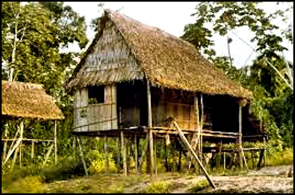
Once the excavation work got underway in the spring of 2007, I was allowed on the site as a representative of the Muscogee-Creek Nation. The archaeologists all assumed that I was a lower form of life and therefore would not understand what they were unearthing. I instantly recognized to same two types of Native American houses that were endemic in the rural areas of Veracruz State. Even in 1970, the indigenous peoples of Veracruz were still building post-ditch houses, except that the newer ones had footings made of concrete rather than clay. Farmsteads in the mountains had a house with solid walls for the winter months and a house with walls made of vertical river cane for the summer months. Farmsteads in the coastal plain often just had the house with river canes. Both regions had open air kitchen sheds and barns on stilts, just like the house compounds at 9CK1.
Out of curiosity, I looked up the Totonac word for “house” in an online Totonac dictionary. It was “chiki”. Holy Toledo! That is the Georgia Creek and Seminole word for house. The rest is history.


The Seminole Platform Chickee
And now you know!
