by Richard L. Thornton, Architect and City Planner
This was the land of my Creek Indian ancestors. My grandparents came here on their honeymoon, but it is much more than that. Very frankly, when I publish my final report on everything that previous archaeologists and I as a Creek Historic Preservation Architect, have discovered here, it is going to change the history of North America. Among many things, I have discovered a seven acre terraced pyramid, built by Soque (Zoque) immigrants from Tabasco State, Mexico . . . a boulder on the side of Chimney Mountain engraved with Early Bronze Age Swedish symbols . . . the quarried stone ashlar brick foundation of a 17th century European house . . . the stone retaining walls of the Apalache-Creek Temple of the Sun Goddess Amana and with infrared, the footprint of a Bronze Age Iberian Sun God basilica temple. Keep in mind that this valley contains the purest gold in the world. It was the site of our nation’s first major gold rush. There was a reason for people to come here from faraway.

The Nacoochee Valley is located in Northeast Georgia, about 75 miles north of Downtown Atlanta and six miles north of the town of Cleveland, GA. It is bounded on the north by the Blue Ridge Mountains and Chimney Mountain volcano. On the south it is defined by a linear range of ancient volcanoes that 17th century Asturian gold miners called Yeona Montes . . . which was their word for a mountain lion. The headwaters of the Chattahoochee River runs through it. The northwestern end of the valley is anchored by Unicoi State Park and the alpine tourist resort of Helen. The southeastern tip of the valley is defined by gorge, created by the Chattahoochee River as it gushes through the eastern edge of the Yeona Range with Class 3, 4 and 5 rapids.

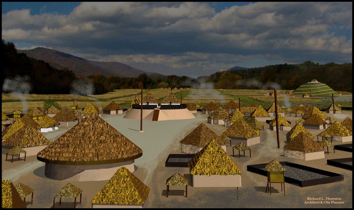
Archaeologist Robert Wauchope identified 26 mounds and 38 Native American town/village sites in the Nacoochee Valley. Using Lidar and infrared imaging, I have identified 16 more mounds. Three of these newly-identified mounds were so large that Wauchope thought they were natural hills. The most spectacular mound that Wauchope missed was the Kenimer Mound on top of Kenimer Hill in the village of Sautee. In the 1970s, a newly arrived family from Florida removed the ruins of a stone temple on top of the mound to build the chimneys and foundation of their “mountain getaway home.” Otherwise, it is in pristine condition.

The Creek Indians called their capital town on the Chattahoochee River here, Apalache . . . from which the Appalachian Mountains get their name. Although this beautiful valley, created by ancient volcanoes, is best known as a popular vacation and weekend getaway destination, it well could be “the Garden of Eden” of the Americas. The famous archaeologist, Robert Wauchope, found that it had been continuously occupied from the last Ice Age to the present. The Nacoochee Valley and the mountains that form it, compose, one vast, multi-cultural archaeological zone that even contains extensive artifacts from late 16th century and 17th century European gold miners, who intermarried with local Creek and Chickasaw Indians. It is now considered to be the most densely occupied archaeological zone in the Americas. [Encyclopedia Britannica] Today, however, it is also Georgia’s third most popular tourist attraction, only exceeded by Downtown Atlanta and Savannah!

In 1939, Robert Wauchope was hired by the University of Georgia to become its first anthropology professor. Most of his income, however, came from a WPA grant to carry out an archaeological survey of northern Georgia. He planned to spend at most a couple of weeks here. He ended up, spending most of 1939 here and still missed many sites. He was forced to do most of his regional survey elsewhere in North Georgia on weekends, once he began teaching at UGA.
Upon arrival in the Valley, Wauchope first went door to door, to ask local residents, if they knew of any locations, where he might find American Indian artifacts. Each family then brought out boxes of artifacts that had been unearthed by plows over the previous century. The entire valley was one massive archeological zone. Artifacts could be found for many feet down into its fertile alluvial soil. They also brought out boxes of 16th and 17th tools, weapons and pottery, either made in Europe or made by Europeans in the valley. Wauchope estimated that there was a tractor trailer load of early colonial period artifacts among these collections. Many of the artifacts seemed to be from the Iberian Peninsula.
When the locals became more trusting of Wauchope, they brought out their most treasured possessions . . . strange stone tablets with some sort of writing on them. They had been turned up by plows in fields along the Chattahoochee River over the previous century. At first Wauchope assumed that the tablets contained a previously unknown Indian writing system. Actually some did contain the Apalache Creek writing system, but when cleaned, most tablets were actually written in Elizabethan English and seemed to be messages from a previously unknown 16th century English colony. He was shown 26 stone tablets and later found two more in the ground, himself.
That same year, a smaller stone, which was found in 1937 near Roanoke Island, NC, received national publicity. It was called the Dare Stone, because it seemed to have been written by Eleanor Dare, the daughter of the colony’s governor, John White. Wauchope suspected that there was a connection, but it seemed illogical that the survivors of the Roanoke Colony would end up in the Nacoochee Valley. Nevertheless, he asked several of his former professors from Harvard University to examine the stones and the dialect of English on them. All of the professors declared the stone tablets to be authentic. However, carved stones found later in the Atlanta Area were determined to be fake and to have been carved recently.
Wauchope ultimately found the tomb of Eleanor and her daughter in a royal cemetery of hand dug caves in Squirrel Gap. A stone tablet inside the tomb stated that it was the burial of Eleanor. He unearthed a stone tablet, written in the Apalache-Creek writing system in the ground, several feet from the tomb’s entrance. Then a couple of week’s later while excavating a large hill nearby to determine whether it was a natural hill or a mound, he found a stone tablet two feet beneath the ground, stating that Eleanor Dare lived on top of the hill, graded to look like a mound throughout the last decade of the 16th century. Soon thereafter, Wauchope was offered a position at the University of North Carolina with triple the salary that he was making at the University of Georgia. The job offer was conditioned on him immediately quitting his job in Georgia and not discussing his discoveries, related to the Roanoke Colony for twenty years.
Like many Harvard graduates his age, Wauchope served in the OSS during World War II and then had a brilliant career as professor at Tulane University for the rest of his life. Ironically, he was best known for his work at Maya cities, but never realized that he that the town named Itsate, which he excavated in the Nacoochee Valley was a word, which meant Itza (Maya) People in English. He also never knew that the Capital of the Kingdom of Apalache was in the Nacoochee Valley and that by 1580, the High King of Apalache had become a Protestant Christian. Thus, it made perfect sense for English Protestants to seek refuge in a Protestant Christian Indian community, where there also lived nearby, Sephardic Jewish gold miners. England and Spain were at war. English Protestants could expect the worst . . . even being burned at the stake, if captured by the Spanish.
Wauchope returned to Georgia 20 years later to finish his research and ultimately write a book about his discoveries in North Georgia. It is called Archaeological Survey of Northern Georgia and was published in 1966. He dutifully reported the discoveries of the authentic Dare Stones and Eleanor Dare’s tomb in this book, but it was a book hardly noticed by his profession and generally unknown to the public until recently.
One big surprise in November 2020
There is something not mentioned in the documentaries below. On October 30, 2020 Hurricane Zeta roared through the Nacoochee Valley, causing extensive flooding. After the waters receded, the owners of the Apalache-Creek Sun Temple site noticed that a large carved stone had been exposed. Out of curiosity, they cleaned the sand and alluvial soil to reveal an 11 feet long carved stone stela. It had stood in front of the Apalache Sun Goddess temple, facing due south. There are some Creek-Itza Maya symbols on the exposed side, but I suspect that there might be more carving on the south face, which is not visible. I have urged the owners not to attempt lifting to a vertical position with a tractor. This is a task that should be done by professionals with the right equipment. That will require funding that the owners don’t have.

This article could gone forever, describing the history of the Nacoochee Valley and the archaeological discoveries made there. The two following videos will provide readers, wishing to learn more, with comprehensive information about this fascinating place in the Southern Appalachians.
This final video provides readers with what was actually said on the 28 Dare Stones in the Nacoochee Valley and Upper Chattahoochee River. A chronological story is told over a period of eight years, when Eleanor Dare and her fellow colonists are waiting to be rescued by her father, Governor John White.

WOW !! I would have loved being let loose on those archaeological sites, sound fascinating. What a wonderful history your Creek people have Richard.
LikeLiked by 1 person
You would especially love the temple mount by the mountain river, where Eleanor Dare lived.
LikeLiked by 2 people
I visited the above pictured site with Richard early summer of 2021. It is everything as described and more. behind the person taking the photograph is an astonishing large cut in the bedrock. Possibly 8 ft in diameter is a perfectly cut concave dish shaped wall. The technology to cut this wall must have been advanced. I was stunned to witness this! oh the stone you see in the picture above are imprints of a left hand and some inscriptions that have worn over time. on the side of the stone facing the river are obvious etchings which look somewhat like head dress crowns on helmets. This place MUST have a re discovery by archeologist. At minimum our National Park Service should take note.
LikeLiked by 1 person