by Richard L. Thornton, Architect and City Planner
On December 21, 2011, I wrote an article for my Architecture column in the Examiner, which was primarily intended to honor the Maya New Year, while simultaneously (and hopefully) attracting the interest of several major university anthropology departments. The stone ruins and earthen terraces needed much more professional examination.
I knew that practically all archaeologists, even in Georgia, were totally unaware of this extraordinary half square mile+ archaeological zone and that it clearly needed to be transferred from the destructive ownership of the US Forest Service to the National Park Service. Since purchasing the land in the 1920s, the USFS had allowed timber-cutting on the lower elevations of the 800 feet high site . . . damaging or destroying many stone walls . . . allowed trees and vines to totally dismantle stone structures . . . and obviously had no clue of the importance of the site, which they had been given stewardship over.
I had no clue that the article would affect me personally or professionally in any way. At the time, I was living in the office of an abandoned chicken house near Track Rock Gap. I desperately was trying to figure out a way to move back to the edge of Metro Atlanta, so I could resume my architecture practice. At the time, I wrote the article, I had been essentially homeless for two years. I would have been delighted to have received 1200 readers for the article.
Instead, I watched in astonishment as the readership numbers skyrocketed by the hour into the millions. Apparently, there was no other significant news in the world at the time. Within a day, it was picked up by news services and TV networks all over the world. My first call telephone was from a reporter with the BBC!
Eventually, the article was published in most nations of the world, including the Mongolian Times. LOL I had millions and millions of readers, but was only paid for the Examiner Article. National Geographic soon called me. When they heard that I had been a friend of their former senior editor, George Stuart, they were immediately were talking an article in the magazine, plus a television special. Even though I was only paid a half cent per view on the article, I soon had the money to buy a state of the art business computer, rent a cabin near Dahlonega, GA and move all my belonging southward over the Blue Ridge Mountains.
Over the next week, I will be publishing articles that relate to Track Rock Gap’s ruins and petroglyphs, plus the general topic of Mesoamerican immigration into North America. Following is the original article.
It has some mistakes and oversights in it. For example, I had no clue that there were at least 16 terrace complexes in Georgia. They had been ignored by the archaeologists. However, it will give readers an idea of what I knew and didn’t know ten years ago!
The Examiner
Massive 1,100+ year old Maya complex discovered in Georgia’s mountains
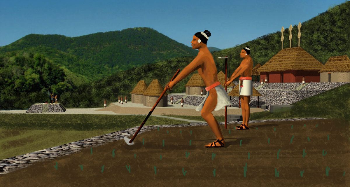
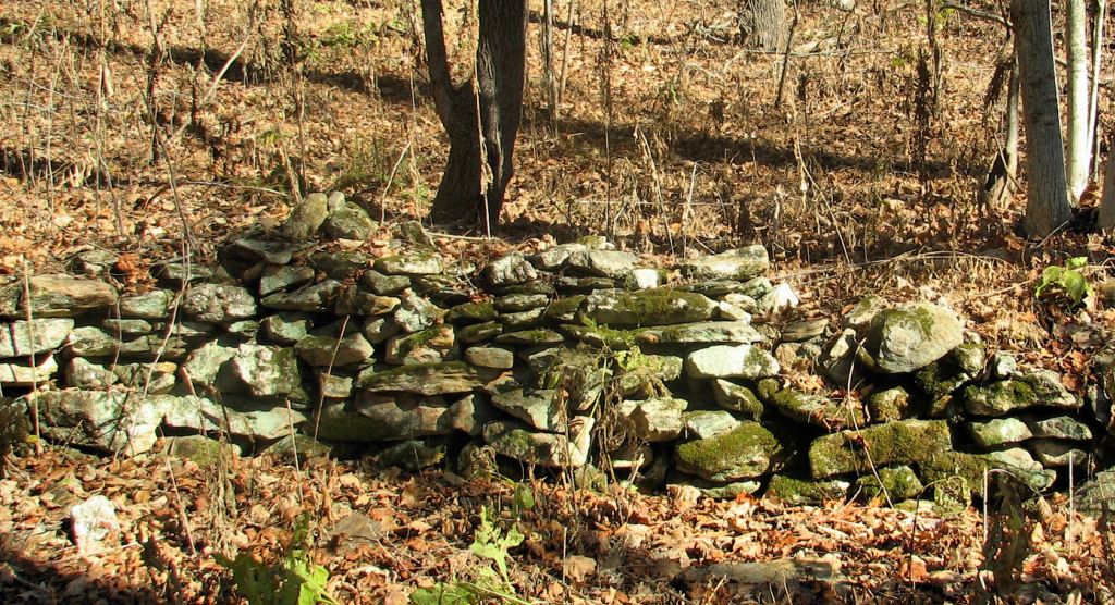
Archaeological zone 9UN367 at Track Rock Gap, near Georgia’s highest mountain, Brasstown Bald, is a half mile (800 m) square and rises 700 feet (213 m) in elevation up a steep mountainside. Visible are at least 154 stone masonry walls for agricultural terraces, plus evidence of a sophisticated irrigation system and ruins of several other stone structures. Much more may be hidden underground. It is possibly the site of the fabled city of Yupaha, which Spanish explorer Hernando de Soto failed to find in 1540, and certainly one of the most important archaeological discoveries in recent times.
BLAIRSVILLE, GA (December 21, 2011) — Around the year 800 AD the flourishing Maya civilization of Central America suddenly began a rapid collapse. A series of catastrophic volcanic eruptions were followed by two long periods of extreme drought conditions and unending wars between city states.
Cities and agricultural villages in the fertile, abundantly watered, Maya Highlands were the first to be abandoned. Here, for 16 centuries, Itza Maya farmers produced an abundance of food on mountainside terraces. Their agricultural surpluses made possible the rise of great cities in the Maya Lowlands and Yucatan Peninsula. When the combination of volcanic eruptions, wars and drought erased the abundance of food, famines struck the densely populated Maya Lowlands. Within a century, most of the cities were abandoned. However, some of the cities in the far north were taken over by the Itza Maya and thrived for two more centuries.
In 1839, English architect, Frederick Catherwood, and writer, John Stephens “rediscovered’ the Maya civilization on a two year long journey through southern Mexico. When their book on the journey was published in 1841, readers in Europe and North America were astounded that the indigenous peoples of the Americas could produce such an advanced culture. Architects in both continents immediately recognized the strong similarity in the architectural forms and town plans between southern Mexico and the Southeastern United States. Most agronomists were convinced that corn, beans and tobacco came to the natives of the United States and Canada from Mexico.
In the decades since Catherwood’s and Stephens’ book, archaeologists have not identified any ruins in the United States which they considered to be built by a people, who had originated in Mexico. This was primarily due to their unfamiliarity with the descendants of the Southeastern mound-builders . . . tribes such as the Creeks, Alabamas, Natchez, Chitimachas and Choctaws. In particular, the languages of the Creek Indians contain many Mesoamerican words.
Historians, architects and archaeologists have speculated for 170 years what happened to the Maya people. Within a few decades, the population of the region declined by about 15 million. Archaeologists could not find any region of Mexico or Central America that evidenced a significant immigration of Mayas during this period, except in Tamaulipas, which is a Mexican state that borders Texas on the Gulf of Mexico. However, Maya influence there, seemed to be limited to a few coastal trading centers. Where did the Maya refugees go? By the early 21st century, archaeologists had concluded that they didn’t go anywhere. They had died en masse.
The evidence was always there
In 1715 a Jewish lass named Liube, inscribed her name and the date on a boulder in Track Rock Gap. When Europeans first settled the Georgia Mountains in the early 1800s, they observed hundreds of fieldstone ruins, generally located either on mountaintops or the sides of mountains. These ruins consisted of fort-like circular structures, walls, Indian mounds veneered in stone, walls, terrace retaining walls or just piles of stones. Frontiersmen generally attributed these structures to the Indians, but the Cherokees, who briefly lived in the region in the late 1700s and early 1800s, at that time denied being their builders.
By the mid-20th century many Georgians held little reverence for Native American structures. Dozens of Indian mounds and stone masonry structures were scooped up by highway contractors to use in the construction of highways being funded by the Roosevelt Administration. Providing jobs and cheap construction materials seemed more important in the Depression than preserving the past.
During the late 20th century, the Georgia state government took an active role in preserving some of the stone ruins. Archaeologists surveyed a few sites. One of the better known ruins became Fort Mountain State Park. For the most part, however, the stone ruins remained outside the public consciousness.
In 1999 archaeologist Mark Williams of the University of Georgia and Director of the LAMAR Institute, led an archaeological survey of the Kenimer Mound, which is on the southeast side of Brasstown Bald in the Nacoochee Valley. Residents in the nearby village of Sautee generally assume that the massive five-sided pyramidal mound is a large wooded hill. Williams found that the mound had been partially sculpted out of an existing hill then sculpted into a final form with clay. He estimated the construction date to be no later than 600 AD. Williams was unable to determine who built the mound.
Williams is a highly respected specialist in Southeastern archaeology so there was a Maya connection that he did not know about. The earliest maps show the name Itsate, for both a native village at Sautee and another five miles away at the location of the popular resort of Helen, GA. Itsate is what the Itza Mayas called themselves. Also, among all indigenous peoples of the Americas, only the Itza Mayas and the ancestors of the Creek Indians in Georgia built five-side earthen pyramids as their principal mounds. It was commonplace for the Itza Maya to sculpt a hill into a pentagonal mound. There are dozens of such structures in Central America.
The name of Brasstown Bald Mountain is itself, strong evidence of a Maya presence. A Cherokee village near the mountain was named Itsa-ye, when Protestant missionaries arrived in the 1820s. The missionaries mistranslated “Itsaye” to mean “brass.” They added “town” and soon the village was known as Brasstown. Itsa-ye, when translated into English, means “Place of the Itza (Maya).”
Into this scenario stepped retired engineer, Cary Waldrup, who lives near Track Rock Gap. In 2000 he persuaded the United States Forest Service to hire a professional archaeologist from South Africa, Johannes Loubse, to study the famous Track Rock petroglyphs, and also prepare a map of the stone walls across the creek in site 9UN367. Waldrup and his neighbors felt that the stone structure site deserved more professional attention. They collected contributions from interested citizens in Union County, GA to fund an archaeological survey by Loubser’s firm, Stratum Unlimited, LLC,
Loubser’s work was severely restricted by his available budget, but his discoveries “opened up the door” for future archaeological investigations. His firm dug two test pits under stone structures to obtain soil samples. In conjunction with the highly respected archaeological firm of New South Associates in Stone Mountain, GA he obtained radiocarbon dates for the oldest layer of fill soil in a test pit, going back around 1000 AD. He also found pottery shards from many periods of history. Loubser estimated that some of the shards were made around 760 AD – 850 AD. This is exactly when Maya population began to plummet.
Loubser described the 9UN367 archaeological site as being unique in the United States, and stated that examples of such sites are only found elsewhere in the Maya Highlands and South America. However, he did not present an explanation for who built the stone walls. He was in a conundrum. The Eastern Band of Cherokees had labeled Track Rock Gap as a “Sacred Cherokee Site.” He had been led to believe that the area had occupied by the Cherokee Indians for many centuries, yet he also knew that the Cherokees never built large scale public works. In fact, the Cherokees established a handful of tiny hamlets in the extreme northeastern tip of Georgia during the 1700s, but the western side of Brasstown Bald Mountain, where Track Rock is located, was not official Cherokee territory until 1793.
Shared research between scholars
The People of One Fire is an alliance of Native American scholars (and their archaeologist friends) that was formed in 2006 after the Georgia Department of Transportation refused to retract a press release which blatantly contradicted several studies by nationally respected archaeologists. Much of its research has focused on tracing the movement of people, ideas and cultivated plants from Mesoamerica and Caribbean Basin to North America. By instantly sharing research rather than hoarding information, very rapid advances have been made in the past five years concerning the history of the indigenous people of North America.
People of One Fire researchers have been aware since 2010 that when the English arrived in the Southeast, there were numerous Native American towns named Itsate in Tennessee, Georgia, South Carolina and western North Carolina. They were also aware that both the Itza Mayas of Central America and the Hitchiti Creeks of the Southeast actually called themselves, Itsate . . . and pronounced the word the same way. The Itsate Creeks used many Maya and Totonac words. Their architecture was identical to that of Maya commoners. The pottery at Ocmulgee National Monument (c 900 AD) in central Georgia is virtually identical to the Maya Plain Red pottery made by Maya Commoners. However, for archaeologists to be convinced that some Mayas immigrated to the Southeast, an archaeological site was needed that clearly was typical of Mesoamerica, but not of the United States.
In July of 2011, Waldrup furnished a copy of the 2000 Stratum Unlimited, LLC archaeological report to People of One Fire members. Those with experiences at Maya town sites instantly recognized that the Track Rock stone structures were identical in form to numerous agricultural terrace sites in Chiapas, Guatemala, Belize and Honduras. Johannes Loubser’s radiocarbon dates exactly matched the diaspora from the Maya lands and the sudden appearance of large towns with Mesoamerican characteristics in Georgia, Alabama and southeastern Tennessee. Track Rock Gap was the “missing link” that archaeologists and architects had been seeking since 1841.
Archaeologist have been looking for vestiges of “high” Maya civilization in the United States, when all along it was the commoners “who got out of Dodge City” when wars, famines, droughts and almost non-stop volcanic eruptions became unbearable. The Itza Maya middle class and commoners became the elite of such towns as Waka (Ocmulgee National Monument) and Etalwa (Etowah Mounds) Just as happened in England after the Norman Invasion, the separate cultures of the commoners and nobility of the indigenous Southeast eventually blended into hybrid cultures that became our current Native American tribes.

Howdy, TRop rate.
On Sun, Dec 12, 2021 at 2:32 PM The Americas Revealed wrote:
> alekmountain posted: ” by Richard L. Thornton, Architect and City Planner > On December 21, 2011, I wrote an article for my Architecture column in the > Examiner, which was primarily intended to honor the Maya New Year, while > simultaneously (and hopefully) attracting the inter” >
LikeLiked by 1 person
Pottery is always good for dating purposes, as long as you know your Ancient pottery shapes and inclusions found within the matrix. Thanks for sharing yet another interesting post Richard..
LikeLike
That is what is very interesting. The terraces are filled with biochar soil, which always must include potsherds. The potsherds are from an earlier period than the radiocarbon date of the soil they are in. This makes me think that the radiocarbon dating either could not measure biochar soil accurately or that the site is about 400 years older than the three terraces that were tested.
LikeLike
Union County Historical Society (Blairsville old courthouse) houses many pot shards, spear heads arrow points grinding stones and full in tact pots. The pots are very old and have stamped decoration on outside rim. All of these finds come from the Blairsville area many near the confluence of Nolta (Nottley) river, Coosa Creek, Butternut creek. Nearby Ft Mountain and the Owl Town Mound (my term not Richards) near Wolf Creek Nolta River confluence also areas rich in archeological evidence represented in artifacts at the museum. Why these items on public display have not caught a professional glance is beyond me. One reason may have something to do with conventional thinking that this is all Cherokee discards from not so long ago. All the items are labeled with some sort of “possible Cherokee” reference. What main stream archeologist want to study trash left behind by victims of the Trail of Tears? Truth is there is an incredible rich prosperous culture that flourished for thousands of years buried inches below the surface of the earth and conventional wisdom. It is time to wake up and see what we are capable of as a human species. Keep up the great work Richard. Will see you soon. Much more to be seen at Trackrock. ; – )
LikeLiked by 1 person
My final article will culminate with a plan to develop Track Rock Gap, Buzzard’s Roost Mountain, Thunderstruck Mountain, Brasstown Bald Mountain and Fort Mountain, seven miles to the northeast in Choestoe, into a national archaeological park or a state archaeological park, plus locations for filming TV programs and movies. Georgia’s counties on the north slopes of the Blue Ridge Mountains, desperately need a destination point of national stature in order to stop the stagnation of their economies. Those of us, fortunate enough to have climbed the Track Rock Archaeological Zone in the winter time, know that the views are spectacular there. After all . . . for most of my life I was and architect-planner, not a thorn in the derrieres of fossilized archaeologists.
LikeLiked by 1 person
Been there several times. I have a home nearby and can tell you from experience that the forest will reclaim anything and everything that’s abandoned within it. This site is worth preserving at the very least.
LikeLiked by 1 person