
Track Rock Gap . . . Ten Years Later
by Richard L. Thornton, Architect and City Planner
Readers may recall that in the introductory article on “Track Rock Terrace Complex – Ten Years Later” I did not discuss the Track Rock petroglyphs . . . which give the gap its name. There was a reason. At the time, like most people, I assumed that it was impossible to either translate or date the petroglyphs on six boulders in the gap. I also assumed that they were irrelevant to either the terrace complex or the “big picture” of understanding what has transpired in eastern North America in the past.
Astonishingly, the answer to the riddle of the Track Rock Petroglyphs would come from an experience I had long ago . . . four days after graduating from Georgia Tech. However, this answer also turns the orthodox early human history of North America upside down.
Our concrete-floored chicken house office in 2011 . . . Home, Sweet Home. The only heat was an inefficient wood stove. Fortunately, there were some nearby woods, where I could saw up fallen trees and limbs. Despite the fact that it had a propane gas water heater and stove, I was receiving horrific electric bills each month . . . as much as $280. They should have been the minimum bill of $24. Just before I moved, I learned that the owners had tapped my electric line and were using the power to grow marijuana in their basement. The Blue Ridge Mountain EMC refused to reimburse me . . . guess because I was poor. The water color painting from architecture school days was of a rock garden I built for my parents. I put the painting there as reminder that this current miserable situation, was not reality and would end, sooner or later.
The Mixed-Blood Goatherd . . . who came in from the cold
About four weeks before writing the first article on the Track Rock Terrace Complex, I was penniless, cold, bored and lonely one night in my little concrete block office-home at one end of an abandoned chicken house near Track Rock Gap. For unknown reasons, the Central Intelligence Agency sent me an invitation on LinkedIn to apply for a career job as an intelligence analyst. The starting pay, during the probation period, was a minimum of $85,000. Much, much higher income was possible, if I proved myself. The potential income was triple what I had ever made as an architect or city planner.
The advertisement contained a link to the very detailed CIA application form and aptitude exam. Just on a lark, I decided to apply for the position and to take the exam . . . knowing full well that the they would be rejected almost as soon as I had gone through the process.
Not wanting to get in trouble with the Feds, I was totally honest about everything – age, a being homeless architect and living in a chicken house, being a former goat herd on a historic Shenandoah Valley farm and being evicted on Christmas Eve to make an example of those, who didn’t submit to organized crime. I even admitted to having a romantic relationship with a beautiful French actress, who was secretly a Sureté spy and initially was supposed to seduce me to get my goat cheese-making secrets. [Vivi, the French Courtesan] The application form even asked about prior ties to foreign espionage agents.
Well, I went on to eating my supper of cabbage, sausages and potatoes, while watching an old flick on YouTube. I assumed that I might get a dump letter in about a month . . . or maybe they would think it was hoax. Then, my telephone rang. The phone ID said “U.S. Government – Langley, VA” . . . Yikes!
The man introduced himself as being a night desk communications officer with the CIA at Langley, VA. Gulp! I sat there in disbelief as the man asked me, if I could start work the next day in Langley. I told him that I lived about 120 miles north of the Atlanta Airport in the mountains, had three herd dogs and not enough money to get to Atlanta Airport.
He responded that they desperately needed a licensed architect with experience in Europe and Latin America right now! A van would pick me and the dogs up first thing in the morning. The driver would give me cash and a Delta plane ticket. The CIA and FBI maintained a kennel for the dogs of their employees in the Atlanta Area, when out of town. He added, “We will probably place you on a farm in the Shenandoah Valley because so many foreign agents make drops out there.”
To my astonished ears, he stated that I had scored higher than most CIA intelligence officers with 20 years of experience. “Obviously, you have been working for the military or some other national defense agency, but we can pay you $125,000 now and much more after your probation period.” I had scored 100 on visual intelligence, world geography and a test like a video game, where you have three seconds to make “kill shots” on bad guys in a busy urban scene, filled with civilians . . . before the bad guys kill you. An important part of the game was discerning the good guys from the bad guys.
The man said that they also needed me at Langley for my sense of humor. He had passed around my application and everybody was rolling in the floor laughing . . . homeless architect in a chicken house . . . evicted on Christmas Eve . . . seduced by a French actress, who is really a spy, trying to steal your goat cheese technology? “Mr. Thornton, how in the world did you dream that all up?” I told them that it was all true. I could hear at least a dozen people laughing the background.
He continued, “ Okay, okay . . . we understood that you have a high security level and couldn’t discuss your real identity, but when you get up to Langley, we have people at your level, to whom you can divulge, who you really are.” [The CIA has homeless employees, living in chicken houses???]
“However, we need to know your real age right now. We know that it isn’t 62. Based on your eye-hand coordination, you couldn’t be more than 35.”
I told him that was my real age. He checked my Social Security file and came back on the phone with bad news. One has to be under 40 to be hired for the first time by the CIA.
He then suggested that they hire me as a contractor. I would make even more money, but wouldn’t have health care or retirement benefits. I could be any age for that. They transferred me to a CIA contractor recruiter, who said that he would get back to me the next day. He didn’t. I guess, which ever Georgia “law enforcement” agency was tapping my phone that week told them that I was a serial killer, big time drug dealer, Al Qaida spy or whatever their lie of the week was.
Between the US Navy wanting me to be a career intelligence officer 50 years ago and the CIA wanting me to go to work the next day, I realized then and there that I have some special talents. I used those talents to unravel the mysteries of the petroglyphs in northern Georgia . . . including those at Track Rock Gap.

Unraveling the Track Rock Petroglyphs
In December 2011, I didn’t feel sufficiently confident to discuss the Track Rock petroglyphs, but that situation was changing rapidly. One can imagine how seeing the “system” first pull off an illegal foreclosure on my home then giving me three days warning to be evicted on Christmas Eve . . . while Fannie Mae had given me preliminary approval for a mitigation loan . . . would be hard on the morale and self-confidence . . . especially when freezing rain came down the side of my tent on Christmas Eve!
I got to thinking. Did it really matter what these jackass neo-Nazi’s in North Georgia did to me? Just on the basis of an aptitude exam, the CIA had wanted me to come to work the next day. Maybe I did have the skills to unravel the true significance of the petroglyphs, when nobody else had attempted it.
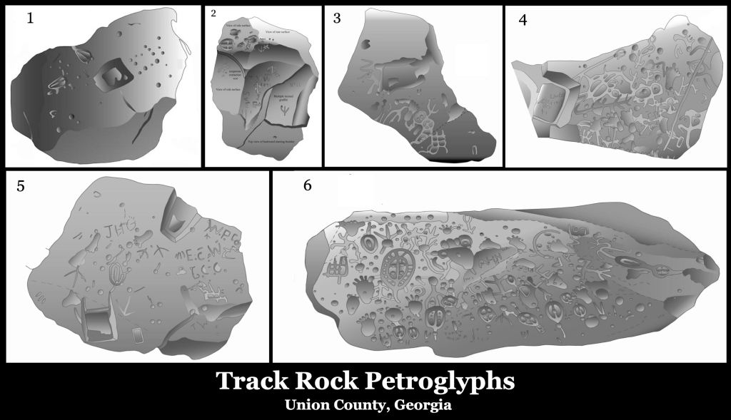
I certainly did not agree with what the US Forest Service’s archaeological consultant, Johannes Loubser, had said about the Track Rock Petroglyphs. He was described as “one of the world’s leading experts on rock art,” but obviously knew nothing about the cultural history of the region around Track Rock Gap. I would later learn that Johannes Loubser had recently arrived from South Africa, when he prepared the Track Rock Petroglyphs report. When he arrived in Atlanta as the Apartheid regime in South Africa was collapsing, he was immediately employed by the National Security Agency for several years. His primary professional experiences in the USA were with the Eastern Band of Cherokees. Perhaps that was the reason that he only quoted Cherokee interpretations of the petroglyphs . . . and did not realize that all of the “Cherokee” place names that he cited were actually Creek or Itza Maya words.
Rather than actually telling us the meanings of the symbols, Loubser merely cited as expert opinions of (1) a tourist, recently arrived in 1832 from Virginia, (2) a self-educated ethnologist from Ohio, who visited the site in 1886 and (3) anonymous, second-hand Cherokee statements from the late 1800s. He ultimately credited the Cherokees as being the creators of the glyphs . . . calling them “graffiti by bored Cherokee hunters.”
Track Rock Gap was in the territory of the Creek Confederacy until 1785 (1784 Treaty of Augusta). In his History of the Cherokee People, Cherokee Principal Chief Charles Hicks specifically stated that no Cherokees lived south of the Hiwassee River until after the American Revolution. Track Rock Gap is south of the Hiwassee River. No contemporary Creek scholars were consulted. They would have told him that there were several Creek sacred symbols on the boulders.
The terrified little Jewish girl
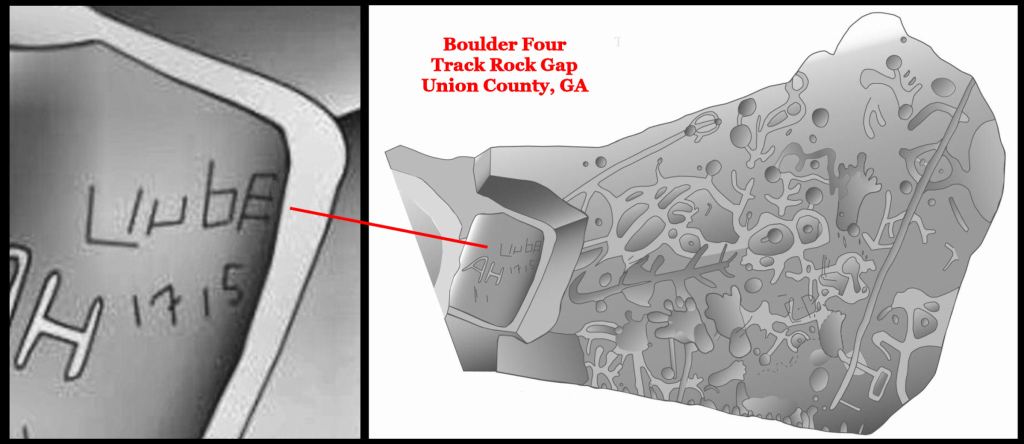
The first omission from Loubser’s report was intriguing graffiti on Boulder Four. It was by someone, who had not quite mastered the writing of the alphabet. We know that she was Jewish because Liube in the 1700s was a common name given by eastern European rabbi’s to their firstborn daughter. In Yiddish, it means “love” or “beloved.”
The date was even more intriguing. The year 1715 was the beginning of the Yamassee Uprising, which began with most of the major tribes in the Southeast killing the European traders in their territory. Approximately, 90% of all whites living in the interior of the Southeast were murdered. What was a European girl doing at Track Rock Gap, which was 200 miles (322 km) northwest of the nearest white settlement?
The girl was about 12 miles (19.3 km) south of an English Factory or trading post on the Hiwassee River. She was about 6 ½ miles (10.5 km) east of a fortified Upper Creek garrison town, 8 miles (12.9 km) northeast of the Uchee village of Choestoa and about 18.4 miles north of the safety of the Itsate Creek town of Cho’ete (Helen, GA today). It contained many mixed blood and Sephardic Jewish residents. My guess is that she was heading south and leaving a message to relatives that she had been there in the gap.

Itza Maya glyphs
My initial research for a book after December 21, 2011, revealed that the Spanish knew about the town on the side of the mountain. It was called Great Copal, because the priests burned copal incense 24/7 at the temple above the terraces. Perhaps copal was one of the crops grown on the terraces. Copal was definitely grown in northeast and north central Georgia. Feral copal plants, adapted to a temperate climate, have become established near small streams, adjacent to pastures.

Gold and diamonds were mined near Great Copal. One Spanish merchant from Santa Elena (South Carolina) traded for a large diamond, which he sold to the Governor of La Florida for 5000 crowns!
During the winter of 2012, while working on a book about the current knowledge on the Itza Mayas and Track Rock Terrace Complex, I gave the petroglyphs another look. What I eventually saw were three Itza Maya glyphs, imposed on much older glyphs, that made perfect sense. What didn’t make sense, however, was that the symbol of the sun god seemed to be one of the old carvings. They are illustrated in the image at the top of the article. The words mean, Great Sungod . . . Lord Kukulkan (Quetzacoatl)! Had a king by that name ruled Copal?

Astonishing discovery concerning the other symbols
Readers probably expect me to say that I learned about the Creek sacred symbols from my uncles or wise Creek elders on an island in the Okefenokee Swamp. Nope! Architect Julian Harris, who designed the original Etowah Mounds Museum, gave us a lecture on the design of the museum and Creek artistic traditions. Harris was also head of the Art Department at the School of Architecture.

Julian Harris often put Creek Indian art and sacred symbols on the buildings that he designed as decorative motifs. There were several on the front façade of the original museum at Etowah Mounds. However, when the museum was remodeled in the mid-1990s, the symbols were removed from the building, I do not know why.

The Swedish connection
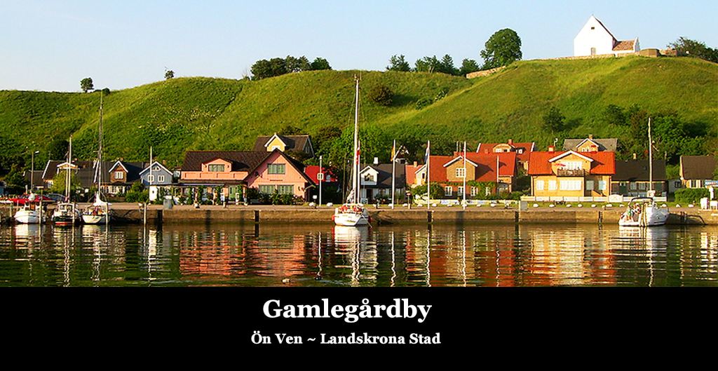
In retrospect, one of the most important days in my life occurred four days after graduating from Georgia Tech. Early in the morning after graduation day, I embarked on a 24-hour trip by jet, bus and ferry to Landskrona, Sweden to work for the Landskrona Stadsarkitectkontoret (City Architect’s Office). On the third day of work, my boss, Stadsarkitekt Gunnar Lydh took me on one hour boat ride to Ven Island to show me my project site . . . the place where I was going to design a pedestrian village.
Adjacent to the project site was one of Scandinavia’s oldest churches and a Bronze Age stone circle shrine . . . identical to the ones in northern Georgia. At the foot of the cliff were boulders, engraved with Scandinavian Bronze Age symbols. They were absolutely identical to the Creek Sacred Symbols. I told Gunnar that. He laughed at me, without stating any response. However, for decades I pondered why there could be the same sacred symbols on both sides of the Atlantic. It didn’t seem possible.
In 2011, I noticed that most of the symbols on the Track Rock petroglyphs were identical to those I had seen and photographed in southern Sweden, but by this time in my career I had concluded that the symbols were shared by many Eurasian peoples prior to the peopling of the Americas. Then in February 2019, I went on a Sunday afternoon ride to Toccoa, GA with my canine buddies.

The destination was Traveler’s Rest State Historic Site, near the Tugaloo River, a major tributary of the Savannah River. Traveler’s Rest Inn was constructed in the 1790s. While it was under construction, a worker found a carved stone on a low knoll, overlooking the river. It was brought back the inn and was used as a foot stone for people getting into carriages and later, automobiles, until 1951 when the historic cluster of buildings was deeded to the State of Georgia.
As you will soon see this carved rock is a priceless artifact, equivalent to the Rosetta Stone. It was left outside on the ground in the backyard of the fenceless historic site, until spring of 2019, when I begged the rangers to bring it inside to a safe location.

The stone overlooked a large Native American town on Tugaloo Island, which was excavated by the team, supervised by archaeologist Joseph Caldwell of the Smithsonian Institute in 1957. The town contained eight mounds, constructed between 800 AD and around 1600 AD. They also found the footprints of much older mounds on top of which the town had been built. Tugaloo is the Anglicization of the Cherokee-nization of the Creek tribal name Tokah-re. Muskogee Creeks pronounce an “R” like an “L” so tokahle is now the Muskogee word for “freckled.”
The Tokah-re branch of the Creeks were known as being tall, brawny, freckles and with brown or red hair. They established a colony on the Chattahoochee River, where Six Flags Over Georgia is. It was known as Tokahpasi . . . Tokah-place of-colony. English speakers called it Tuckabachee.
Oh, did we mention that Tokah-re is also two Irish Gaelic words, meaning “Principal Kingdom.” “Re” is actually a very old root word throughout northern Europe, which was applied to tribes that had formal governments and a king. It is the root of many English, Scandinavian, Dutch and German words. Thus, we had a powerful Creek province composed of people with proto-Northwestern European features with an archaic Irish name. Hm-m-m.
Are you sitting down? The Tugaloo Stone has generally been ignored by the archaeology profession. A University of Georgia glanced at it in the late 20th century and suggested that “it was probably an early form of Cherokee writing.” That’s all the official archaeological survey of the region states. About 20 years ago, some other University of Georgia professor came along and interpreted the symbols to be “a prayer to the god Baal.” Okay-y-y.
Well, there is a problem. Archaeologist Joseph Caldwell excavated the Tugaloo Island town site and determined that it was occupied by ancestors of the Creek Indians from around 1000 BC to at least 1700 AD. The Cherokees had nothing to do with the Tugaloo Stone.
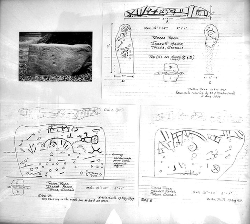
Historians Ed and Bobbie Smith did do charcoal rubbings of the stone in August 1977. Four days later, archaeologist Bobbie Snow converted the rubbings to sketches on grid paper. There was no attempt to interpret what she drew and their work was forgotten. Charcoal rubbings just don’t “grab” faint details like digital photography does.
I photographed all sides of the stone . . . setting my digital camera to first visible light and then infrared. I then shined an ultraviolet light on each side to pick up eroded details. Once back at my abode, I downloaded the image into my computer and looked at the magnified images on the screen. Many of the Creek sacred symbols that I had seen in Sweden and on the Track Rock boulders were here. In addition, some sides of the rock were covered with Swedish Bronze age navigation and astronomical symbols. Some of them seemed upside down. I clicked the tab to turn the image 180 degrees. For 225 years, everybody had been looking at the Tugaloo Stone, upside down!
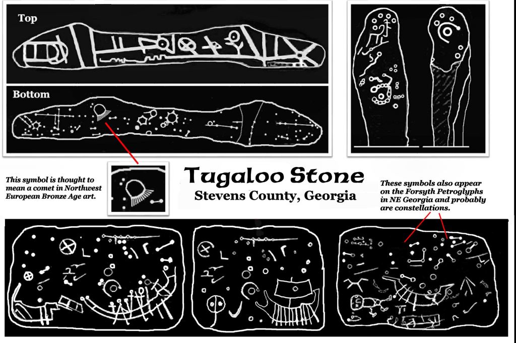
Holy cow! Those are Scandinavian, Phoenician and Minoan Bronze Age ships! This is proof that Bronze Age Europeans came to the Georgia Gold Fields. However, all of the symbols are Scandinavian Bronze Age. There was no Mediterranean civilization writing. I am not sure what that means. Perhaps the Scandinavians lived here, but the other civilizations visited here. I should add that during the Bronze Age, the inhabitants of southern Sweden would have looked like tanned skin, brown-eyed, dark haired Northern Sami or mixed-blood Native Americans. The genes for blue eyes and blond hair came later.

I looked at my slides of petroglyphs in southern Sweden. Almost all the symbols on the Track Rock petroglyphs could be found in the vicinity of Nyköping, Sweden on the coast of the Baltic Sea. They have been dated by geologists to be (at least) around 2000 BC, but the symbols were probably written on bark much earlier. They represent the oldest known writing system in northern Europe. Most are quite different than the Middle Bronze Age, Late Bronze Age and Iron Age petroglyphs in Scandinavia.


There is something else very significant about the Nyköping petroglyphs. Many of the same glyphs can be found in the earliest forms of the Maya writing system. In fact, the “hene” symbol at Nyköping and Track Rock Gap was the first “Maya” glyph translated by anthropologist David Stuart. In all three regions, the glyph had the same meaning – Sun God or the High King (Great King). Furthermore, the numerical writing system portrayed at Nyköping is identical to that of the Mayas.
Maya oral history matches this discovery. The Maya tribes are certainly American Indians, but Maya tradition remembers that they originally lived to the north in a land of ice and snow, where they were persecuted by giants. The Maya’s ancestors migrated southward along the eastern edge of North America until they reached a land where it never snowed and there were no giants. Readers may recall that the Iron Age Scandinavians also remembered a time, when they were persecuted by “ice giants.”


Most of the symbols on the Track Rock boulders were carved by a Bronze Age people, who originated in Scandinavia. However, because several symbols at Track Rock and Nyköping so strongly resemble the Maya writing and numerals, it is highly possible that Proto-Mayas carved the glyphs at Track Rock and several other similar petroglyphic sites in the Georgia Mountains. Thus, the Mayas would have had a cultural memory of the Southern Appalachians.

This discovery changes everything. It also explains why we have so many stacked stone structures in northern Georgia, which are identical to those in Neolithic, Copper Age and Bronze Age Scandinavia, Scotland, Ireland and Galicia. There is an oval-shaped stone shrine in eyesight of my rear bedroom window (The Alec Mountain Circle) which identical in shape, size and construction to stone ovals constructed in eastern Scotland, where the Picts lived . . . during the Bronze Age.

The Creek People have always prided themselves in having the hybrid vigor and progressive intellects of a mixed people . . . the blending of descendants from several ancient civilizations in order to survive the shock of European colonization. However, until recently I never realized how many ingredients went into that recipe for genetic, cultural and linguistic Brunswick Stew!
Life is indeed, a box of chocolates!

Howdy, Have you ever thought about being a college professor?
On Thu, Dec 16, 2021 at 10:15 AM The Americas Revealed wrote:
> alekmountain posted: ” Track Rock Gap . . . Ten Years Later by Richard L. > Thornton, Architect and City Planner Readers may recall that in the > introductory article on “Track Rock Terrace Complex – Ten Years Later” I > did not discuss the Track Rock petroglyphs . .” >
LikeLiked by 1 person
Actually, several universities in the Southeast were interested in hiring me as an architectural history and preservation professor. However, each time they would suddenly cut off communications without explanation. This was pretty much the situation with women I dated after September 2000. However, some with strong Democratic Party affiliations, did have the decency to call or write me so I would know about the police in Georgia calling them with lies.
LikeLiked by 1 person
This is my favorite brain food. Our Creek ancestors are bringing their story to light. Keep on keeping on. Amazing! Fascinating! What a puzzle…with no picture on the box. 😎
LikeLiked by 2 people
Absolutely fascinating post Richard, I was mezmarised I just love those petroglyphs and all that history that goes with them.
LikeLiked by 1 person