The Science of Aging Mounds
by Richard L. Thornton, Architect and City Planner
In February 1996, the National Park Service sponsored a two week training workshop in Vicksburg, Mississippi on the structural behavior of earthen fortifications and Native American mounds. It would turn out to be one of my most important short term educational experiences. The classes prepared me for a radical change in my professional career in the 21st century. It was also perfectly timed so I could drive down to New Orleans afterward and attend Mardi Gras with my sister’s family! LOL
Two of the instructors turned out to be archaeologists, who had worked on my Shenandoah Valley farm in the late 1980s. Other instructors included a civil engineer and architect with the NPS, who both specialized in historic preservation. They taught us the technical information and procedures for carrying out a scientific analysis of a mound or fortification, when we wanted to conceptualize it as architecture, rather than an ornament on the landscape. A multi-disciplinary NPS team had been studying Native American mounds at Shiloh National Battlefield Park in western Tennessee. Their discoveries significantly changed the way we thought platform mounds were built.
Another team began their research project at Civil War fortifications. The highly innovative Confederate fortifications around Vicksburg, Atlanta and Petersburg, VA were designed by professional civil engineers. Many of the engineering drawings still survived. They were studied intensely by German military engineers at the beginning of World War I, when the United States was still neutral, and became the model for German earthen fortifications on the Western Front. Germany also copied the brilliant use of branch railroads by the United States Army, which terminated very close to the Federal trenches at Petersburg.
Because the engineer’s drawings enabled the study team to know the exact dimensions of earthen fortifications, it was possible to exactly calculate their changes over time. However, there were two important differences between Civil War fortifications and Native American mounds.
Civil War fortifications were quickly erected with shovelfuls of earth tossed through the air. The soil particles were loosely arranged with air pockets. Vertical surfaces were reinforced with boards or logs. Battles would often leave the earthen forms with many pockets and holes, where water would later pool.
Mounds were constructed much more slowly with baskets of earth poured onto the incomplete surface then compacted with human feet. The bases of some mounds were reinforced with vertical logs. The team, working at Shiloh National Battlefield Park, discovered that many, if not most, platform mounds were plastered with a thick coat of clay to provide some protection from the erosive effects of rainfall. An even thicker coating of clay was packed on the finished horizontal surfaces. These finish clays were often bright colors and obtained from clay pits a considerable distance from the mound being constructed.
The study team found that solid clay mounds were the most likely to keep a form, similar to their original appearance, but clay was extremely difficult to dig with the wood tools. They also told us that there were no sharp edges on mounds as artists always portray them. Being a plastic material and easily dissolves in water, it was absolutely impossible to maintain 90-degree angle corners between sides of clay or clay finished mounds.
More commonly the cores of mounds were either alluvial soil or sand, finished with a reinforced clay stucco finish. We know from eyewitness accounts that the Apalache mixed mica flakes with the final coat of clay stucco, which had exactly the same effect as fiberglass in concrete cement stucco. Eyewitnesses also tell us that some proto-Creek cultures in Georgia placed a lime-based stucco coat on their houses and temples. The lime was made from burning shells. Crushed shells were also mixed into the stucco to reinforce it.
The architect stated that archaeological excavations seemed to be missing a absolute necessity of Southeastern Native American towns . . . storm water drainage. Drainage ditches were identified around the largest mound at Kolomoki Mounds, but they seemed to have been overlooked at such large towns as Moundville, Alabama and Etowah Mounds, Georgia.
Mound A at Etowah Mounds in Cartersville, GA covers about 3 acres (1.2 acres). A one-inch rain fall would cause 10,890-cubit feet of water to flow off the mound’s sides! Cartersville averages 48 inches of rainfall a year, which equals a total of 522,720-cubic feet of water a year, flowing off the mound annually!
The engineer and architect also stated that archaeologists consistently underestimated the original height and breadth of Native American mounds. Even if regularly maintained, the plastic nature of soil and clay would cause the mound to be shorter and broader over time. We will explain further, below. Here are the ways that Native American mounds and ceremonial earthworks change over time.
The archaeology, architecture and civil engineering professions in the United States are generally unaware that northern Georgia and east central Alabama contain a significant number of mounds that were veneered with field stones like those in Mesoamerica. I have found some in protected locations that still had clay mortar, binding the stones together. I suspect that this was commonplace, but in exposed locations the clay has eroded away. The stone veneered mounds will also be discussed.
1. Rain Erosion – The heavy year-round rainfall of the Southeastern United States steadily washes away the surface of an earthen structure. Eventually, all mounds would become invisible to the naked eye due to erosion alone. The rate of erosion is determined by the density of the mound material, the surface of the mound material, the slope of the mound and annual rainfall.
Planting grass on the sides of the mound slows down erosion, but does not stop it. The only material that would completely stop erosion of a mound would be artificial turf.
2. Riverine Erosion and Accretion – Most of the Southeast’s large mounds were constructed in flood plains of rivers or large creeks. Catastrophic floods can either erode the bases of mounds or pile alluvial soil against their bases, making a mound seem shorter than it really is. A mound examined today might show signs of both types of damage.
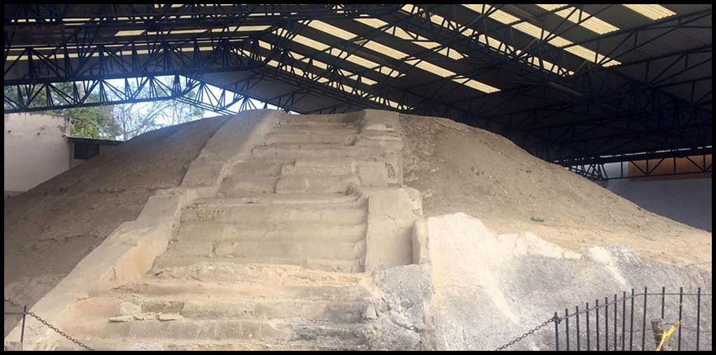
Archaeologist Adam King excavated the portion of the main ramp of Mound A at Etowah Mounds in 1994 as part of his dissertation for the University of Pennsylvania. He discovered that the ramp was actually stairway, very similar to the Huastec Mound pictured above. He also discovered that the lower 15 feet of the mound was concealed by alluvial soil that was deposited by the massive 1886 flood on the Etowah River. Thus, although this mound is officially 63 feet high, what survives of the mound today is actually 78 feet (23.8 m) high. However, as you will soon find out, that was not its maximum height.
3. Reservoir erosion – Many Native American mounds in the Southeastern United States today are under the surface of many made reservoirs. Particularly in the former channels of mountain rivers, the lake actually flows like a river. When the mound is fully inundated, there is enormous pressure on the super-saturated clay of the mound. It eventually will be completely ground away, but initially erodes to a triangular shape, with the narrow side pointing up stream.
4. Marine erosion – This category involves the action of ocean waters against Native American structures, which in coastal areas included those compose of earth/clay, shells and sand. In most cases, exposure to ocean waters has been the result of rising sea levels. Some mounds appear to have always been beneath the surface the water. They functioned as platforms for timber pile houses. However, there are two categories of sea water exposure . . . those facing the open ocean and those placed on the edge of tidal marshes.
- Earth/clay mounds: These are primarily location on the banks of estuaries along the Gulf Coast. They are particularly common along the edges of Pensacola Bay and Perdido Bay near Pensacola, FL and Mobile Bay near Mobile, AL. Earthen mounds exposed directly to ocean waves or hurricane tidal surges are quickly destroyed. One pounding from a hurricane may be sufficient.
- Sand mounds: These were primary built on the northern Florida coast and the inland sides of islands on the coast of Georgia, South Carolina and North Carolina. Some were visible during the colonial period, but almost all near the ocean are invisible today.
- Shell mounds and shell rings: Shell mounds set back from the ocean or tidal marshes seem to survive the attacks of Mother Nature better than earthen mounds. However, once directly exposed to waves, hurricane tidal surges or even rising ocean levels, they generally dissolve over time. The reciprocating action of waves loosens the cohesion of the shells. One by one, they are pried loose from the structure and returned to the ocean.
5. Wind erosion – The effects of wind erosion are most severe when the soil and clay components of a mound become exceedingly dry. Clay particles lose their cohesion when dehydrated. Wind will gradually blow away surface particles across the entire surface of the mound or earthwork . . . even mounds planted in grass . . . but is most severe at the edges of the top of the mound. Wind velocity is greatest there and functions like a file, grating against the junction of the side and the top. The overall effect would be to reduce the size of the horizontal face of the mound . . . its cap.
6. Particle compaction – Over time, gravity causes individual soil or clay particles in a mound to move closer together. Acting alone, particle compaction would cause the earthen structure to shrink in all dimensions. However, other forces are also at work, which would cause the vertical shrinkage to be out of proportion to the lateral shrinkage.
Because most mounds in both North America and Mesoamerica were expanded over time . . . as were the masonry pyramids in Mesoamerica, also . . . the older portions of the mound are denser and damper; therefore, more resistant to the forces of wind and rain. Look at the photo of the mound in Tamaulipas. The newest, outer layers of the mound have been partially removed by nature, but the earlier layers more clearly display their original appearance. This will also be the case of the Nikwasi Mound.
7. Subsidence: The impact of nature is akin to particle compaction, but actually changes the form of the mound. Over time subsidence would make the height lesson but the circumference increase. In laymen’s terms, the bottom of the sides spread outward. Both clay and soil are plastic materials. It is the same principal as when one squeezes a ball of clay . . . its thickness decreases as its diameter increases.
8. Undocumented excavation: As soon as people from the Old World settled around abandoned Native American mounds, they began digging into them to find artistic trophies, skeletons and of course, the eternal search for “Injun gold.” The first generation of self-described professional archaeologists were little better than grave diggers. They were trying to find trophy artifacts for their private collections, their sponsoring museum’s collections and to wealthy families in the Northeastern United States, whose donations made the expedition possible.
The Nacoochee Mound, originally much larger than its reproduction is today, was completely destroyed by artifact collectors and first generation archaeologists. Not one artifact from that mound can be seen in the county, where the mound is located. Almost all excavated artifacts are either in private or museum collections in the Northeastern United States. The skeletons were not replaced into the mound, when it was rebuilt. Presumably, intact skulls and bones are in museum warehouses and display shelves of mansions.

Case Study – Etowah Mounds
Here is a classic example of late 20th century and early 21st century “professional” archaeologists not doing their homework. The owners of Etowah Mounds “rented out” the archaeological zone to artifact collectors throughout the 19th and possibly early 20th century. The diggers were charged $200 a month. That’s the equivalent today of about $7-8,000 a month is today’s dollars . . . depending on when the grave robbing occurred.
The artifact collectors excavated the top level of the mound, looking for artistic trophies and “Cherokee gold. The damage was expanded in the summer of 1864 by the First Ohio Volunteer Infantry Regiment, camped out at Etowah Mounds for four months. They constructed the ramp to haul cannons and caissons to the top, which was converted into a fort.
The commander of the First Ohio, Col. Gates Thruston, suddenly had an enormous Native American artifact collection at the end of the Civil War. He claimed to have bought the artifacts from soldiers, building fortifications around Nashville. Apparently, no one in Tennessee questioned that explanation. However, he was not stationed in Nashville when the fortifications were built . . . and most of the fortifications were not built in bottomlands, where mounds were built, but in the rolling hills, south and west of the city. He was most definitely stationed at Etowah Mounds, when Mound A was ravaged. In fact, he stayed in one of the large plantation-style houses on the Etowah River, whose owners found their artifact collection missing after he departed.
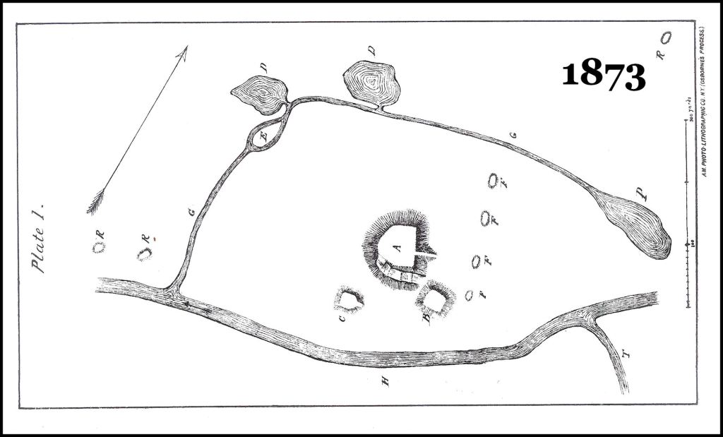
When they supervised the excavation of Etowah Mounds B and C between 1954 and 1956, Arthur Kelly and Lewis Larson did not attempt to find early drawings of the mounds from the first half of the 19th century. Yale Natural Science professor and Protestant missionary, Elias Cornelius, measured the mounds in 1818 and drew a site plan. The Cherokees, living nearby told Cornelius that the Cherokees had first settled on the Etowah River around 1795. They did not know who built the mounds and would not live near them, because they were haunted.
Flash forward to the mid-1950s. Throughout the excavation of Etowah Mounds, the archaeologists involved argued over who built Etowah Mounds . . . the Creeks or the Cherokees. They assumed that Mound A (the biggie) had been abandoned, while under construction. Very little digging was done there. They completed destroyed Mounds B and C. The famous Etowah marble statues were found at the bottom of Mound C in a collapsed tomb, next to a field stone-walled temple.

The Mounds B and C that you see today are inaccurate reproductions, created by a grading contractor, employed by the Georgia Parks Department. Dr. Kelly excavated a massive rectangular banquet hall in the center of the three mounds, which could have held at least 500 people. It is never seen in artist’s paintings or site plans produced by contemporary archaeologists. As we mentioned earlier, in 1994 Adam King found that Mound A and probably the other two mounds were accessed by steps, like the pyramids in Mexico.

Here’s what’s happened since then:
- There is no mention of the banquet hall or steps in the Etowah Mounds Museum, which was remodeled in the mid-1990s.
- There is no mention in any reference or archaeological paper (other than my Adam King) that base of the existing mound was actually fifteen feet below the current ground level.
- There is no mention by the museum or any archaeologist that the eastern corners, plus the north and south ramps were washed away by the terrible flood of 1886, which as it receded, deposited the 15 feet (4.6 m) of alluvial soil.
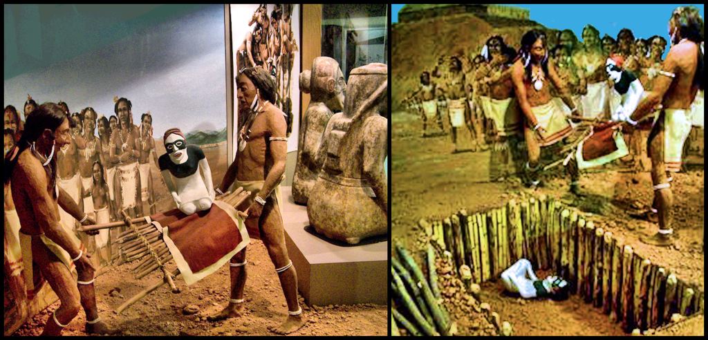
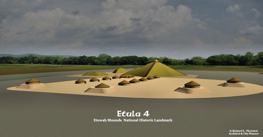
- The elaborate highlight of the museum is a three-dimensional exhibit of the two famous marble statues being accidently dropped into a shallow grave at the TOP of Mound C. The exhibit states that the grave was dug hastily as an enemy was attacking and burning Etowah. (Its real name is Etula, an Itza Maya word.)
- In 2006, both a team of archaeologists using ground radar and I, using infrared analysis, determined that Etula was laid out in a planned pattern of streets and blocks. Within most blocks were public courtyards. This is the same way that Teotihuacan was laid out.
- In spring 2007, a delegation of Cherokee officials and Western Carolina University professors arrived at the museum, demanding that all references to the Creek Indians be removed from the museum and replaced with Cherokee . . . the real builders of the mounds.
- In 2012, the Eastern Band of Cherokees Historic Preservation Office adopted as their logo a shell gorget found in Mound C, during the 1925 excavation.
- All publications by professional archaeologists like to use this water color birds-eye view of Etowah Mounds. In proportion to Mound A, the area of the town is about one half the area, it should be. As stated above, the corners of mounds were rounded, not sharp edged as artists like to portray them.


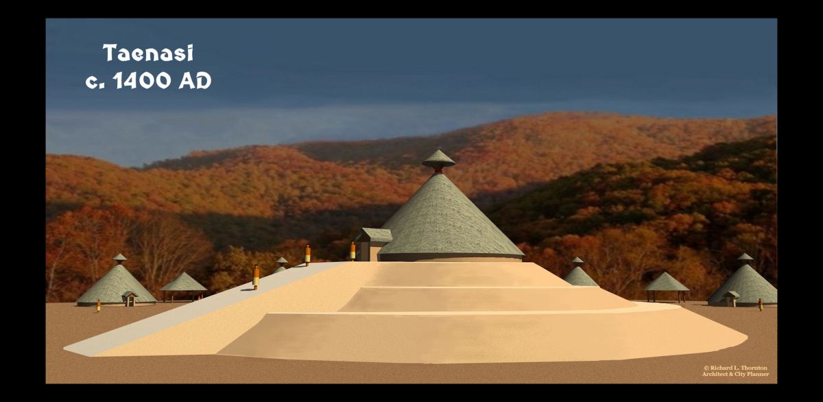
Well, there is another problem. This is what Etowah Mounds looked like in 1818. The architectural rendering that follows, Elias Cornelius’s drawings, is probably what Etula looked like in the 1600s. It seems to have been an earthen copy of the great pyramid at the Mayan city of Uxmal in southern Yucatan State.

In its final form, it was at least as tall as Monk’s Mound at Cahokia (100 feet ~ 33.5 m). The town was not permanently abandoned in 1585 after being sacked by an enemy as museum viewers are told.

And now you know!

Howdy, First time I have heard about the cannon(s).
On Tue, Jan 4, 2022 at 8:30 PM The Americas Revealed wrote:
> alekmountain posted: ” The Science of Aging Mounds by Richard L. Thornton, > Architect and City Planner In February 1996, the National Park Service > sponsored a two week training workshop in Vicksburg, Mississippi on the > structural behavior of earthen fortifications and Na” >
LikeLiked by 1 person