
Overlooking the Chattahoochee River in White County, GA
The earthen structure measures approximately 2,000 feet (610 m) north-south and 1,200 feet (366 m) east-west. The maximum height of the serpent today is approximately 72 feet (22 m).
Who built this structure?
I don’t know! We might never know.
How was it built?
It was probably built the same way as the nearby Kenimer Mound . . . being sculptured from the hillside, using a process of cutting and filling.
Article by Richard L. Thornton, Architect and City Planner

Preliminary CADD 3D model of earthworks
Chattahoochee (river) is an Itza Maya word meaning “Carved stone” (stela) – “Shallow River.” The Sky Serpent was the principal deity of the Itza Mayas, who probably first migrated to the Georgia Mountains from central Campeche State, Mexico in the late 500s AD, after a massive asteroid or comet struck off the South Atlantic Coast in 539 AD. The Itzas believed that comets and meteors were manifestations of the Sky Serpent. Several smaller Sky Serpent effigies, made of piled stones or earth, have been found on Georgia mountain tops.
Later Itza Maya immigrations occurred around 800 AD from Chiapas State and 1000 AD from northern Yucatan. The Itzas soon intermarried with other peoples, who had migrated from southern Mexico and eastern Peru, to become the ancestors of the Creek, Chickasaw, Soque (Miccosukee) and Seminole Peoples. The oldest known example of traditional Chickasaw architecture was found by archaeologist Robert Wauchope in 1939, immediately west of Kenimer Hill in the Nacoochee Valley.
LIDAR scans for this research is being provided by the GIS office of the Georgia Mountains Regional Development Commission in Gainesville, GA, An alliance of Maya Indians in Campeche State, Mexico and conservationists, living near Yosemite National Park in California, are helping fund a comprehensive, three dimensional computer model of the Chattahoochee River Base from its source to its entrance into the Georgia Piedmont. Several of the Californians were friends of the late, beloved Georgia actor, Pernell Roberts, who encouraged Richard Thornton in his quest to unravel Georgia’s early history. Roberts, like Thornton, was a Creek descendant from Waycross, GA. He did much behind the scenes to advance the education of Native Americans and encourage conservation of our nation’s natural environment. Both the Roberts and Richard’s family were members of Trinity Methodist there, but some of Richard’s mother’s relatives had close ties with the Roberts Family going back before the Civil War.

Apalache was the name that most of the Creek Indians of Georgia called themselves until the 1750s. It was also the name of their capital, which was located in the Nacoochee Valley until a horrific smallpox plague struck in 1696. It means, “Descendants of People from the Sea.”
The capital was then moved southward to Indian Springs in Butts County, GA and two decades later back to the Mother Town at Ocmulgee National Historic Park in Macon, GA.
The so-called Apalachee of Florida were allies of the Apalache Kingdom, but never called themselves by that name until it was given to them by the Spanish. Apalachen, the plural of Apalache became the name of Georgia’s Mountains, but in the 20th century became the name of all the mountains in the Eastern United States.
Since 2018, the non-profit Apalache Research Foundation has been focused on unraveling the mysteries of the ancient architecture found in Northeast Georgia. During 1885 and 1886, an archaeological expedition, sponsored by the Smithsonian Institute, discovered and mapped hundreds of mysterious stone and earthen structures. The report on this expedition and accompanying map was published in the forerunner of Smithsonian Magazine, but soon forgotten by the archaeological profession.
Because the road system and land use patterns in the Northeast Georgia Mountains have changed radically since 1886, it took me six years to identify all of the archaeological sites mention by the Smithsonian’s chief archaeologist, Cyrus Thomas. Back then most roads were barely more than wagon trails. Batesville was named Soque. Sautee was located three miles from its current location at the intersection of Highways 255 and 255A, while what is now Sautee was name Itsate (Itza People) and the largest community in the Nacoochee Valley was name Mauldin Mill, at the intersection of Hwy. 17 and Hwy. 255A. Maudin Mill was predominantly African-American in composition. The community had several stores and churches, plus a public school for African-American children.
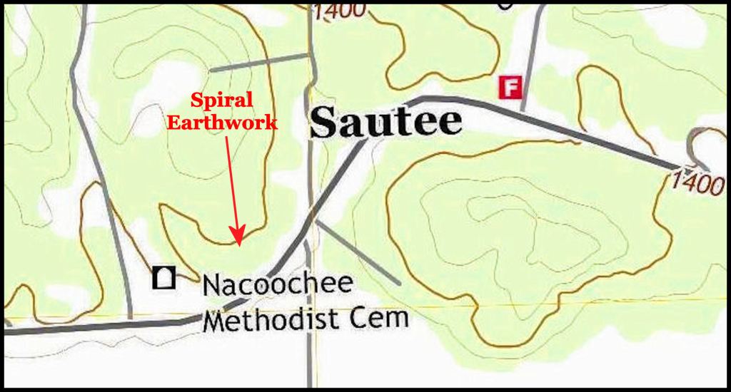
Both the large Kenimer Mound and this Spiral Earthwork are invisible on USGS Topo.
The snake jumped out and bit me!

I first noticed an odd looking geographical formation near the Nacoochee United Methodist Church in 2019, when it was revealed by a higher resolution version of Google Maps. It reminded me of the symbols on the gorget, worn by Keepers of the Creek Wind Clan. However, it was so large that it didn’t even dawn on me that it could something created or altered by humans.
Then the Nacoochee Methodist Church had an “open house” for its cemetery, whose use long preceded the church . . . including some ancient burials belonging to Asturian gold miners in the 1600s. Soon after arriving at the cemetery, I noticed what was clearly the location of a Native American shrine on a hilltop overlooking the church and the valley . . . facing due south.
I later realized that this apparently high point was merely a point on the tail of the massive form on the landscape. It took several return trips with GPS and laser-based surveying equipment to convince me that this was an artificial form carved out of a somewhat different natural feature.

Google Maps terrain model of the Serpent Effigy and Kenimer Mound
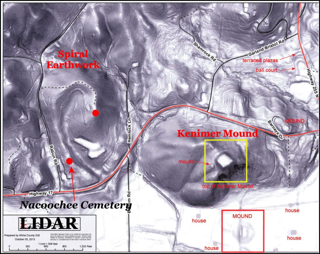
LIDAR scans exaggerate the height of the ground surface, while removing all trees and shrubs. On site, the Serpent Earthwork looks more like the CADD drawing that I did. In the lower right, you can see the location of Native American mounds and houses that are invisible on site. The Nacoochee Valley LIDAR scan has revealed hundreds of previously unknown structural remains. They include several terrace complexes. It will take me years to examine all of these vestiges in the 12 mile long archaeological zone.
Archaeologist Robert Wauchope stated that the Nacoochee Valley contains the largest and densest concentration of human occupation sites and villages in North America. Humans have lived here continuously since at least the Ice Age. Several of the village sites were occupied from around 1200 BC to 1700 AD. During a year of searching the valley, Wauchope could find no definite Cherokee villages or artifacts . . . despite several inaccurate historical markers, erected in the Valley by the State of Georgia. He did estimate that perhaps a tractor trailer load of European artifacts from the 16th, 17th and 18th centuries have been unearthed here, plus at least two 17th century Spanish gold mining villages.

The form of this serpent reminded me of a much smaller site that I studied in 2013.
About the author

Trail of Tears Memorial in Council Oak Park, Tulsa Oklahoma
Richard L. Thornton has been the Architect-of-Record for the construction or restoration of hundreds of buildings in the Southeastern United States and Sweden. He has been awarded eight state, two national and one international architectural awards. He holds a Professional Degree in Architecture from Georgia Institute of Technology and an M.S. in Urban Planning from Georgia State University. He was the first recipient of the Barrett Fellowship from Georgia Tech, which enabled him to study on-site all of the major and many of the minor Mesoamerican archaeological sites in Mexico. His fellowship coordinator was Dr. Román Piña Chan, Curator of the Museo Nacional de Antropologia in Mexico City. One of the greatest archaeologists of the Twentieth Century, Piña Chan was later appointed Director of the Institutio Nacional de Antropolia E Historia de Mexico.
During the period of 2004 through 2008, Richard was an Architectural History consultant to the Muscogee-Creek Nation. In 2008, the Oklahoma Centennial Commission chose Richard to be the Architect of the planned Trail of Tears Memorial in Tulsa. He worked closely with the brilliant Creek sculptor, Dan Brook. Since that time, most of Richard’s professional energy has been devoted to Architectural and Native American history of the Americas. He has published 16 books on either Architectural History or Southeastern History and appeared on several national or international television programs. Richard continues to apply the technical skills of an architect and urban planner to unraveling the complex past of the Americas. Oh, and by the way . . . All of his Native American DNA is from southern Mexico and eastern Peru!

Very interesting Richard and part of this post ties in with Graham Hancock’s book with regard to the serpent. I think in his last book called America Before.
LikeLiked by 1 person
https://www.cnn.com/style/article/largest-native-american-cave-art-scn/index.html
You might find this interesting.
LikeLiked by 1 person
I would suspect Armuchee, GA for other serpent mounds on Google Earth.
Although this could be natural, peaks usually aren’t as sharp and consistent in GA limestone.
See 34.330141,-85.349991 near Mt. Berry, and on Mt. Berry there seems to be more terracing as well… see pictures of the house of dreams nearby.
LikeLiked by 1 person
Yes, there is a fieldstone serpent overlooking Dalton, GA and two of them on Fort Mountain, overlooking Chatsworth, GA
LikeLike
Amazing work and thank you for sharing.
I can only guess there could be hundreds more scattered throughout GA, AL and TN.
I’ve watched a few series on serpent mounds near Nova Scotia, on the History Channel, and until happening across a History Channel interview, would never have really thought of connecting mid to late Mayan culture to Georgia and even into Tennessee.
I grew up at the foot of Lookout Mountain with the legend and lore of John Ross, and his father having been one of the first few Cherokee inhabitants to have settled on a cabin at the foot of Lookout in modern day St. Elmo/ Rossville, GA with very little habitation until the 1890s. There are suspicious terraces known as rifle pits on Lookout Mountain between Ochs and Scenic highway you should check out sometime… the suspected last overhill battle between the Cherokee and John Sevier was “supposedly” fought in that area in the 1790s, but I think the terracing far precedes that.
Little would it be suspected that the Cherokee just happened to walk into as much land holding as they did as vassals to the Uchee, and to imagine DeSoto tromping through before the conquests and deaths of these native inhabitants, and the absolute balls of DeSoto and fellow Conquistadors, to abruptly and hostily rob native mounds at this time, must have been wild crazy times (at a pretty significant cost no less) to view a vast but quickly subsiding empire.
LikeLiked by 1 person
One of my gg-grandfathers was in one of those rifle pits! He was captured at Vicksburg after being seriously injured by shrapnel, then exchanged just in time to fight the entire Atlanta Campaign . . . finally surrendering with what remained of the CSA Army of Tennessee at Greensboro. None of my ancestors owned slaves, but like a whole bunch of other Southern boys, got sucked into fighting somebody else’s war.
LikeLike