
One of those towns is still thriving today after at least 3,000 years of existence. It was once part of truly lost civilization that had evolved over time. The town of Apalache was the capital of the Kingdom of Apalache, which once stretched 500 miles (804 km) from Southwest Virginia to Southwest Georgia. It seems to have been an incubator from which bands of people left to found towns elsewhere in the Southeast. Nevertheless, when Savannah was founded in 1733, the Creek Indians still called themselves Apalache . . . not Muskogees. That name would appear about 20 years later.
All communities in the Valley were suddenly abandoned around 1700 AD. The termination point is marked by a mysterious 5 to 15 feet [1.5-4.8 m) layer of alluvial sand, containing very few artifacts! Above the sand stratum, almost all artifacts are of 18th or 19th century Anglo-American manufacture.

by Richard L. Thornton, Architect and City Planner
Native Americans were primitive farmers?
In high school Social Studies and college Anthropology, North American students are taught that the Indigenous agriculturalists of the Southeast practiced such primitive farming techniques that they could only stay in one location for a few generations. The supposition was not based on any real scientific research. It was really just a Eurocentric prejudice, reinforced by a profession that until very recently, was obsessed with obtaining trophy artifacts from large mounds for museums and university donors in the Northeastern United States.
The life expectancy of “mound-builder towns” was said to be no more than about 150 to 250 years, due to exhaustion of the soil and the destruction of forests around the town sites. Supposedly, those who survived to the bitter end of these indigenous metropolises scattered to other locations, where the soil was fertile.
In the 21st century, the discovery of a former dense population of sophisticated farmers in Amazonia has totally discredited the prejudices of past academicians, but almost no attention has been given to what a mid-20th century archaeologist actually found in an Appalachian Valley that had been inhabited continuously since the Ice Age. The myths about primitive Native American farmers continue to be replicated in textbooks, used both by high school and college students.
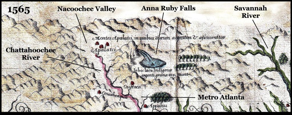
A section of the 1565 map of Floride française by Jacques LeMoyne, resident artist and cartographer at Fort Caroline. It was based on a six month expedition to the region in 1564 and 1565 by Lt. LaRoche Ferrière. French officials planned to build the capital of New France on a plateau overlooking the Oconnee River . . . approximately where the University of Georgia now is situated in Athens, GA.
What a famous archaeologist really uncovered
In 1939, archaeologist Robert Wauchope, a recent graduate of Harvard University, was hired by the Works Progress Administration (WPA) to carry out an archaeological survey of all counties from the Atlanta Area northward during a single year. The next year he was to become the first anthropology professor at the University of Georgia.
Even though he grew up in Columbia, SC Wauchope did not have a clue what he had taken on. His profession assumed that American Indian populations in the Southeast were concentrated a few big towns with big mounds. The remainder of the Southeast continued to be a wilderness. Instead, Wauchope quickly realized that the region formerly had a high population density.
Indeed, the chroniclers of the De Soto Expedition had stated that while marching through what is now Georgia, they never lost sight of either houses or cultivated fields. Most of the people lived in dispersed villages and farmsteads. Then he arrived in the Nacoochee Valley and realized that it would take many years just to study that valley adequately. We will tell you more about that later.
Wauchope only taught at the University of Georgia a short period. Word got out that he had discovered the tomb of Roanoke Colony survivor, Eleanor Dare, and had personally unearthed stone tablets that identified in Elizabethan English, where she was buried and where she lived her last ten years in the Nacoochee Valley. Not only that, Wauchope had collected 24 other stone tablets that farmers had unearthed since the 1830s, which were also engraved with Elizabethan English then given them to Brenau College, to be studied by his former professors at Harvard.
At the time, North Carolina officials were trying to discredit a play being performed at Brenau, which portrayed a band of Roanoke Colony survivors being given sanctuary by the King of Apalache. They offered Wauchope a position at the University of North Carolina, paying triple his salary at the University of Georgia . . . if he would leave the University immediately, in the middle of a semester. That he did . . . and in the process, not nearly completing his obligations to the Federal government for a thorough survey of all North Georgia counties and a published report on what he found.
Career wise, it was a good move. Wauchope was named director of the UNC Laboratory of Archaeology. However, that did not last long either. After Pearl Harbor was attacked, Wachope was soon made an elite intelligence officer in the OSS, forerunner of the CIA.
In his brilliant career as a professor at Tulane University, he became well-known for his ground-breaking work at Maya cities. Wauchope remained silent concerning his discoveries in the Nacoochee Valley and did not even enter the State of Georgia again for 20 years.
He did not complete his mandated report on the North Georgia Archaeological Survey until 1966. The WPA no longer existed so he published it through the Society for American Archaeology.
This smells of a secret non-disclosure agreement with the State of North Carolina . . . kind of like when I couldn’t tell anyone for 20 years, why I was at the Munich Olympics, when it was attacked by the Black September terrorist group. Thus, at critical period in the 20th century, archaeologists created faulty orthodoxies due to lack of information about Wauchope’s discoveries.
Continuous human occupation
Wauchope had planned only to spend two weeks in the Nacoochee Valley, but ended up spending most of the year there and still did not excavate most of its archaeological sites. He was forced to go out on weekends and holidays, while teaching at the University of Georgia, to marginally cover counties in North Georgia outside the Chattahoochee River Basin. In doing such a superficial job elsewhere, he completely missed dozens of important town and agricultural terrace sites.
In the Nacoochee Valley and the Upper Chattahoochee River Basin, all the way down to Atlanta, Wauchope found many artifacts of mankind’s continuous occupation of the region since around 8,000 BC. While digging through the alluvial sand to reach settlements in the Nacoochee Valley, however, he incidentally found 35 Clovis points! Wauchope didn’t dare mention this to his professional peers at the time. The official orthodoxy of his profession’s Lords of Seth was that the Clovis Culture was located in New Mexico and Arizona only.
Settlement Spacing: Throughout the Nacoochee Valley, the principal mounds of long-occupied communities were typically spaced from 3000 to 4000 feet (914-1219 m) apart, but some near the acropolis (today the village of Sautee) were only separated by 100-200 feet (30-60 m). They were essentially neighborhoods of a large town.
South of the Sal Mountain Gorge, southwestward to present-day Columbus, GA, the long-term occupied towns and larger villages were all located on river shoals or waterfalls. They generally were 3-5 miles (4.8-8 km) apart. The consistent location of Proto-Creek towns along the shoals of rivers and large creeks in northern Georgia strongly suggests that these settlements began as seasonal village sites at locations where fish and mussels were traditionally harvested earlier by non-agricultural peoples.

(3D CADD test image) While working briefly at the mound on the lower right corner, Robert Wauchople completely missed the massive earthen pyramid at the top of a steep slope to the north . . . while directing laborers to dig test trenches at the five sides mound, just south of of the Kenimer Mound. The Kenimer Mound is identical to the earthen pyramids carved from hills to honor the Sun God, by the Highland Mayas of Chiapas, Guatemala and Belize.
Architecture: Wauchope’s book provided sketches of building footprints from several villages and neighborhoods, but his minimal knowledge of Indigenous American architecture limited his capacity to interpret the footprints. There was an extraordinary variety of Pan-American architectural styles constructed simultaneously in the Nacoochee Valley. Villages or neighborhoods literally in eyesight of each other often contained entirely different styles of houses, out-buildings, public buildings and earthworks during the same time periods.
In the 2 ½ mile (4 km) distance between the Sautee General Store and the Hardman State Historic Site, visitors to the valley 500 years ago would have seen within individual villages:
- Houses with entrance doors on their corners, typical of the suburbs of Chichen Itza around 950 AD and Etula (Etowah Mounds) around 1000 AD.
- Large round, conical roofed houses typical of the Arawaks in northern South America, the Tekesta in Southeast Florida and the houses on the acropolis of Ocmulgee between 900 AD and 1000 AD.
- Medium sized houses with semi-circular ends like the Maya houses in Campeche and typical Chickasaw houses of the Colonial Era.
- Houses typical of the Soque in Tabasco and western Chiapas (Mexico), the Soque in Northeast Georgia and on the acropolis of Ocmulgee after 1000 AD.
- Medium and small-sized houses with rectangular floor plans, typical of the Totonacs in Mexico, the non-Nahuatl peoples of southern Veracruz and the later occupation of Etula (Etowah Mounds).
Once the computer model is debugged and loaded into the Arlantis Virtual Reality software, the Americas Revealed will provide readers with detailed architectural renderings of the Nacoochee Valley’s architecture.
Earthen Pyramids and Burial Mounds: Wauchope identified 38 Indian mounds in the Nacoochee Valley, but missed the largest ones, which he assumed were natural hills. His discoveries include some smaller burial structures, which are oval shaped and constructed of stacked field stones with a top lacing of white quartz stones.
Most pyramids and burial mounds in the Nacoochee Valley began as burial sites then grew into multiple burial sites and often eventually into ceremonial mounds. Layers of different colored soils or clays marked the times when the mounds were expanded. These were the strata that archaeologists typically see at town and city sites around the world. Until the late 20th century, analysis of strata was one of the few means to determine time periods.
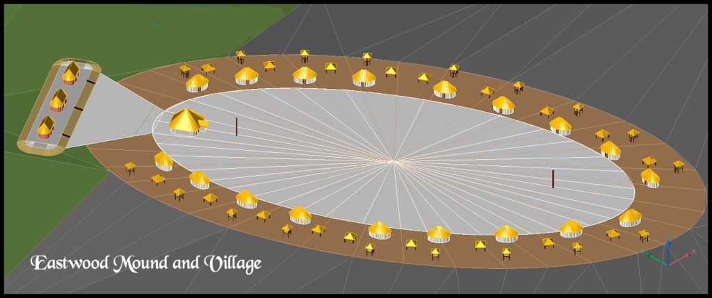
For example, there was a large, but not tall platform mound on the north end of the Eastwood Village Site, which is immediately west of Kenimer Hill, on which sits the Kenimer Mounds and immediately south of the Sky Serpent Earthwork, which I discovered in January 2023. Wauchope found that it began as two separate burials of important personages which grew into two separate burial mounds. However, in the last phase of construction, the two mounds became an earthen platform running East-West about 250 feet (76 m) long.
Wachope usually did not see distinct strata in the soils of Nacoochee Valley town and village sites. Once into the dense concentration of artifacts found in occupation sites, Wauchope observed something totally unexpected . . . seemingly continuous occupation, going back thousands of years. He could see more than one type of pottery style being produced at the same time or at certain levels the rapid evolution of one style to another. Radiocarbon dating had not been invented yet, so Wauchope used the approximate dating of pottery styles recently identified by Dr. Arthur Kelly at Ocmulgee Mounds to describe sites in the Nacoochee Valley.
That was another surprise. The Nacoochee Valley was 128 miles (206 km) due north of Ocmulgee. All of the pottery styles found at Ocmulgee Bottoms could also be found in the Nacoochee Valley. The same people lived at both locations at the same time. Wauchope also discovered some pottery styles that were not found around Macon, GA or any other archaeological site, known that time.
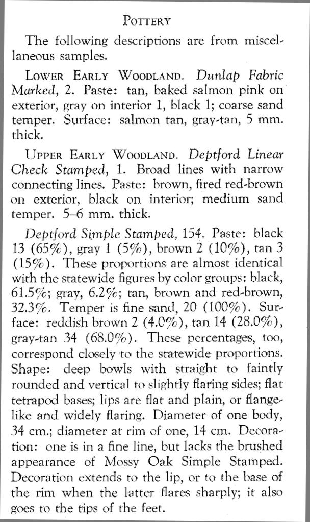
The Eastwood Village Site contained examples of every style of pottery, found in Northern Georgia between 1000 BC and 1700 AD! At the time, Dunlap Fabric Marked pottery was though to be in the oldest style in the Southeast. It strongly resembled the Cord-marked Beakerware of the Late Neolithic, Copper and Early Bronze Ages in northern Europe. It is proof that Southeastern Native Americans were weaving fabric and nets over 3,000 years ago. Below is an excerpt from Robert Wauchope’s report.
What Robert Wauchope’s report revealed was a 12 mile long valley at the southern edge of the Appalachian Mountains, which became increasingly sophisticated as more peoples relocated there. The physical evidence clearly portrays a cosmopolitan society in which multiple, distinct ethnic traditions were continued over a period of many centuries and sustainable agricultural practices were highly sophisticated, making it possible for all members of this society to thrive in a rather densely occupied mountain valley.

This further demonstrates my belief, based on a rock art found in the Red River Gorge area of Kentucky, that this rock art, a face, contains icons (spiral eyes, beads in the hair, a hat, and a mouth with a protruding tongue) INFLUENCED by remnants of cultures from the Maya living in southern North America – a protruding tongue is also seen in the center of the golden sun disc Montezuma supposedly gave Cortez. Alan Cornette
LikeLiked by 1 person
The god with the protruding tongue was Aztec – Tlaltecuhtli
The Mesoamerican god with the elephant like nose was Maya – Chaak
Later on this year, I will be showing y’all amazing similarities between photographs that I took in Mexico and Southeastern Indigenous art.
LikeLiked by 1 person
I appreciate your time and effort you put into making history known. How can I send you a personal message?
LikeLike
At the top right of this webpage, click contact. You can send private email via this tab.
LikeLike
I have some mixed feelings regarding Cherokee land claims and Hiawasee/Ocoee land sale in 1829 to 1832, (including Chattanooga) where the Cherokee really had no notable habitation in many of the places the negotiated for sale, nor were they all aware of the sale and negotiation of their land to the US Government, until it was too late. I see it more like being at thr right place at the right time secretive manifest destiny/ capitalist real estate negotiations in that respect.
I have traditionally felt bad for the Cherokee during the Trail of Tears, no one really deserved to be marched in brutal conditions or die, but Andrew Jackson, with his fiery temper, never forgot that some of the Cherokee fought and sided with the British during the Revolution, then they turned around and fought with Jackson during the War of 1812.
This was carried with Jackson into his Presidency, and duplicitous allegiance, was certainly not in Jackson’s thoughts or vocabulary for America. That and the fact that Dalonogha, GA (purportedly claimed by Cherokee) stood in the face of a Gold Rush during this time too, so Manifest Destiny made a land deal too good for a few in the Cherokee council to refuse. The rest were forcibly rafted or marched out to Oklahoma soon thereafter, and those allegiant folks, woth whom I do sympathize.
I grew up on some of this useless “Cherokee” land, sold for pennies on the dollar, where this land did not see vast development until the 1890s. Im sure a few Civil War soldiers marched upon it, during the battle above the clouds, and possibly Chickamauga, and I know that Sherman razed the very few mansions in the area. Largely, the only Cherokee person who lived in a small shack in the area on the Eastern side of Lookout Mountain, was the noted Chief John Ross ‘the half Scot’.
Chief John Ross was half Scottish his father was fully Scottish and assimilated with the Cherokee after having an issue with a boat wreck near Chattanooga.
Wahautchie Pike on the western side of Lookout Mountain was purportedly named after a Wauhautchie, a Cherokee Chief who was hailed as responsible for driving out the Creek during the 1750s war with the Creeks. Im not so sure how victorious the Cherokee really were. There was some sacred burial ground near this area, so it was largely left alone and revered, not necessarily or largely inhabited. I do not believe this was all completely attributed to Cherokee sacred burial ground and there were people here hundreds if not thousands of years before them.
I tend to think the Western Cherokee expansion may have been scattered enough for the Cherokee just to be at the right place at the right time to stake a claim.
LikeLiked by 1 person
https://www.tngenweb.org/polk/ocoeedistland.htm
This is an interesting account of some Cherokee land dealings, kind of an abandoned and scandalous land deal conducted by a few Cherokee.
Chief John Ross tried to fight it. It included Cherokee “claim” from Ocoee and Hiawasee regions down to Georgia and Alabama.
Im not saying all Cherokee were responsible for this sale, nor were they all earlier and necessarily allegiant to the Crown during the Revolutionary War either, but there were some like Dragging Canoe, who created noted trouble in this area.
Ultimately, after this land deal, and several others it, would displace many Cherokee on the Trail of Tears, which has a great memorial tribute off Hwy 60 near the Hiawassee River near Blythe’s Ferry.
It is truly a sacred and beautiful site, where the Hiawasse and Tennessee Rivers converge with a gorgeous cliff side vantage (and if you like wildlife, an awesome spot to see thousands of Sandhill Cranes at the Hiawassee River Preserve down the road) but again, perhaps not always, nor traditionally attributed directly to the Cherokee people.
This would be a logical and mentionable DeSoto route to reexamine, as not having specificity to Cherokee occupation as well.
LikeLiked by 1 person
https://www.loc.gov/resource/rbc0001.2019gen13701/?sp=15
This is an interesting account of DeSoto’s journey.
LikeLiked by 1 person
Another good read on DeSoto.
https://ia600301.us.archive.org/21/items/anarrativeofthee34997gut/34997-8.txt
LikeLiked by 1 person