They were first discovered by archaeologists Cyrus Thomas (1886) and Robert Wauchope (1939) then completely forgotten by subsequent generations of their profession. I have found several more with on-site analysis, satellite imagery and LIDAR.
What do you do, when Late 20th century archaeologists concealed legacies from the past so thoroughly that they forget their existence? Nowadays, historic preservationists can’t protect these ancient structures, because, they are unknown to communities and governmental agencies.
There is so much information about the cultural achievements of Native Americans that is being left out of the history and anthropology textbooks. Now, we are not talking about the speculations of talking heads on TV reality shows, but educated professionals. The man, who recently discovered the oldest known mounds in the Americas on the LSU campus in Baton Rouge is a highly respected geology professor.
Something weird happened in the generation of archaeologists in the Southeastern United States that followed Arthur Kelly, Lewis Larson, Joseph Caldwell, Gordon Willey, William Haag and James Ford. These professors redacted knowledge on archaeological sites that did not quite fit their version of the past. This was especially true in regard to extremely ancient earthworks, stone architecture and large civic structures in the Lower Southeast.
So, the next generation after the” history doctors” generation received an incomplete education. They don’t know, what they don’t know.
Like . . . did you know that Dr. Arthur Kelly discovered a Scandinavian-style stone boat burial and petroglyphs on the west side of the Chattahoochee River at Morgan Falls Dam near Roswell, GA? On the east side, he discovered stone cairns and agricultural terraces like those at Track Rock Gap. These secrets from America’s past are now in the Chattahoochee National Recreational Park (NPS).
On my first date in 1995 with Julie, a Sumatran Princess from a Roswell Methodist Single Adult Sunday Class, [The Shenandoah Chronicles] we hiked down to this incredible archaeological site. I instantly recognized the petroglyphs as being like the Bronze Age petroglyphs on Ven Island, Sweden, but unanticipated romance later that day caused me to suppress that memory for 20 years . . . until I chanced upon Dr. Kelly’s Morgan Falls archaeological report.
The Southern Mexican connection
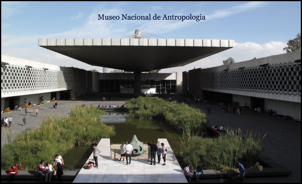
July 6, 1970: In my notes from my first meeting with Dr. Román Piña Chan, curator of the Museo Nacional de Antropologia de México, he clearly stated that there were strong cultural similarities between the Southeastern Ceremonial Mound-builders and the Formative/Early Classic Period civilizations of southern Veracruz, Tabasco, Chiapas and Campeche. This is the region where both advanced agriculture and large towns first appeared. Its peoples were the progenitors of the so-called “Olmec” Civilization, the Epi-Olmec Civilization and the Classic Period Gulf Coast Civilization. They also participated in the Maya civilization, but never built large stone structures.
In fact, the Pre-Columbian architecture of southern Mexico is identical to the traditional architecture of the Creek Indian Confederacy. Several of the tribal members of the Creek Confederacy had the same name and traditional architecture as their relatives in southern Mexico. This is especially true of the Soque (Zoque, Sokee, Jokee) who claim to have been the last confederacy member to arrive from Mexico. The Soque were one of several peoples in Tabasco, who sculpted earthen pyramids from hills. I am finding many sculpted earthen “Indian mounds” in the Nacoochee Valley of Georgia.
The Highland Mayas, Kekchee Mayas, Chontal Mayas and the ancestors of the Creek Indians in Georgia were the only peoples in the world, who built pentagonal earthen pyramids as platforms for important temples. The Kenimer Mound in the Nacoochee Valley is identical to many such pentagonal pyramids that can be seen today in Chiapas, southern Guatemala and western Belize.
You can imagine how I cringed back in 2012, when Georgia archaeologists made ignorant public statements that “no Maya architecture has ever been found in Georgia.” They just knew nothing about the subject, but before the media were pretending to be experts.

This is a virtual reality architectural rendering of a Chontal Maya town site that I visited on the coast of Tabasco State, Mexico . . . near the Tuxtla Mountains (Sierra de las Tuxtlas). Note the five-sided mound in the center and the horseshoe shaped ball court on the right.
The king of sports in southern Mexico

Most people, including archaeologists in the United States, are not aware that stick ball was the king of sports in Teotihuacan and societies under its domination in southern Mexico. As seen at left, the sport was played with sticks identical to those used to play hurling, since at least the Bronze Age, in Ireland and Scotland.
Mesoamerican stickball fields were usually horseshoe shaped and could be as large as an American football field or even an Irish hurling field. Most had earthen banks on the sides, where spectators sat or stood. Hurling utilizes goal posts, similar to those in American football, but smaller. Mesoamerican stickball probably used goal posts, but this is not known for certain.
While on my fellowship in Mexico, I encountered several horseshoe shaped playing fields in southern Veracruz and the coastal regions of Tabasco and Campeche states. They were in the ruins of Chontal Maya, Tamaul-te Maya, Cho’i-te Maya and Soque towns. I should add that the earthen pyramids in these towns and villages were identical to those structures called “Indian mounds” in the Lower Southeastern United States.


A forgotten discovery by the Smithsonian Institute
In 1886, the Smithsonian’s chief archaeologist, Cyrus Thomas, wandered through my section of the Northeast Georgia Mountains, while his marginally educated assistant, John P. Rogan, was supposed to be supervising laborers at the excavation of Mound C, at Etowah Mounds in Cartersville, GA. Thomas’s initial objective was the Nacoochee Mound, but then a local told him about the massive Alec Mountain Stone Oval near my current home. On the way Alec Mountain, he noticed smoke coming from Chimney Mountain, an active gas volcano.
Thomas then steered his horse directly past what is the entrance to my development to visit the extreme northwest corner of Habersham County. He discovered dozens of mysterious structures that were unlike what he had seen in the Midwest. These included a terraced earthen pyramid, smaller earthen mounds, stone veneered mounds, megaliths AND a large ball, horseshoe shaped ballcourt, the size of a football field.
In his report within a Bureau of American Ethnology bulletin, Thomas stated that the playing area was rimmed by a fieldstone wall and was immediately north of the Soque General Store, which is now called the Batesville (GA) General Store.
For the past five years, I have been trying to locate the stone and earthen structures, seen by Cyrus Thomas in the Soque River Basin. Many remain hidden in dense forests owned by family heirs, who do not respond to my letters, requesting access to measure and photograph these legacies.
LIDAR scans, provided by the Habersham County Department of Planning have enabled me to find the acropolis of the Soque capital and what remains of the Soque ball court. Apparently, most stones were utilized by local residents to build chimneys and foundations. The Batesville Fire Department was built on top of the former playing area.

A ball court on the side of Track Rock Gap
In 2011, while analyzing the ruins of the terrace complex at Track Rock Gap with laser measuring devices and infrared imagery, I came upon a very large terrace, about 80 feet below the acropolis. It was large enough for a village, but also contained a horseshoe shaped ball court. This one was about the size of a basketball court. This one may also been used for chunky games or even the type of ball game, played by the Lowland Mayas, which involved hitting a rubber ball through a wooden or stone ring.

Discovery of a large stadium in Sautee, GA
During Robert Wauchope’s archaeological survey of northern Georgia in 1939, he attempted to find the 100+ structures noted by Cyrus Thomas on a sketched map of Northeast Georgia. He couldn’t find any of them . . . namely because he was a practitioner of the deeply embedded tradition among Gringo archaeologists of not using historic maps, topographic maps and Native American dictionaries.
Astonishingly, the US Geological Survey had prepared accurate topographic maps of the North Georgia Mountains for use by the US Forest Service to acquire tracts for the Chattahoochee National Forest and by utility companies to build four dams near the headwaters of the Soque River. Wauchope made no effort to obtain them.
Since Wauchope did not use anything other than highway maps, he did not know that Soquee, GA had changed its name to Batesville and that Sautee, GA had moved three miles to be the location of the Nacoochee Academy.
Wauchope assumed that Sautee was the same village as Soquee then began looking around for large mounds and a large ball court surrounded by a stone wall. He was at the site of the capital of the Itza Mayas in North America, not the capital of the Soques in North America. . Itsate means “Itza People” in Itza Maya! He did find much Native American detritus on the grounds of the Nacoochee School, which replaced the privately-owned Nacoochee Academy in 1928.
Several mounds had been leveled to build Nacoochee School and Nacoochee Presbyterian Church, across the road. In back of the then 10-year-old school building, Wauchope found a horseshoe-shaped chunky court, which was much smaller than Thomas’s ball field and had an earth embankment around it, not a stone wall.
Wauchope eventually realized that a horseshoe shaped earth form in front of the Nacoochee School was a stadium. He listed the remaining archaeological features of the Nacoochee School site on Georgia’s first Archaeological Site Inventory.
In 1979, when state historic preservation officials prepared plans for the Nacoochee Valley National Historic District, they ignored all of the 38 archaeological sites, studied by Wauchope, mentioning only the Nacoochee Mound, which Wauchope listed, but did not investigate.
In 1990s, the Georgia Department of Transportation destroyed part of the eastern spectator terraces of the stadium, when realigning GA Hwy. 255 . . . a very minor highway. No archaeologist was consulted, even though the new route destroyed or altered several designated archaeological sites along its new route. The massive Fritchey Mound was hauled away as land fill in 1993.
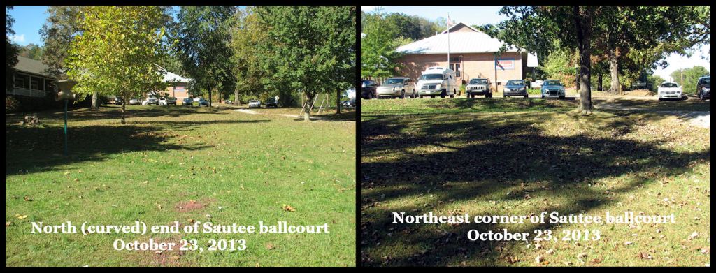
In October 2013, Marilyn Rae and I measured and photographed the Sautee-Nacoochee stickball stadium. At that time, the playing field was 115 feet (35 m.) wide and 343 feet (104.5 m) long. Three terraces for spectators were in astonishingly good condition, except where they were destroyed by the GADOT.
In 2015, professional archaeologist and expert on the Itza Mayas, V. Garth Norman, spent several days in NE Georgia, examining sites with me that I suspected were settled by people from Southern Mexico. He agreed with my interpretation. Norman found obsidian blades and chips on the southern end of the stickball stadium at the Sautee-Nacoochee Community Center.
He took the obsidian samples back to his office. The obsidian was definitely not from the western United States and could have been from México. I later learned that there is some obsidian in the volcanic landscape of Northeast Georgia. It could have been local.

In 2016, I wrote and published, The Nacoochee Valley, Ancient Crossroads of the Americas, so that its residents would be aware of the extraordinary history of the landscape there. The book was solely on the archaeological work done in the valley by archaeologists Charles C. Jones (1859), Cyrus Thomas (1886), George Heye (1915), Robert Wauchope (1939) and Mark Williams (2001). The book intentionally left out my own research. With very little promotion, the book has sold over 2500 copies.
On April 9, 2017 I gave a standing room only lecture on the book at the Sautee-Nacoochee Community Auditorium. The rent for auditorium was paid by a lady in the community, who had read the book. Again, as in the book, I emphasized the past work of highly respected archaeologists and did not mention my actual credentials on the subject.
Prior to this lecture, the Sautee-Nacoochee Community Association leadership had gone to the extraordinary step of publishing via email, newspaper and its website a protest letter by a handful of local (very obviously) white people, claiming to be Cherokee Indians, that I should not be allowed on the premises. The notice also stated that because of controversial nature of my “theories”, the organization did not endorse my lecture and was requiring rent to be paid by others.
*Both Sautee and Nacoochee are Anglicizations of Creek words. Sautee and Chattahoochee are also Itza Maya words. During over a year of work in the Valley, Robert Wauchope never found a single Cherokee village valley, nor even an artifact that could be Cherokee. All Native American artifacts were similar or identical to those found in the Macon, GA area. The Sautee-Nacoochee Community Center was built on top of what’s left of an Itza Maya-Creek mound!
My lecture on the past work of archaeologists in the Nacoochee Valley was well received by the crowd. Attendants crowded around me afterward to autograph the book and ask questions. Many people wanted me to give a second lecture on what I was doing in North Georgia. That was never allowed to happen. Instead, I created the People of One Fire channel on Youtube, where I could post videos about my current discoveries and experiences I had long ago, while on the fellowship in Mexico.
I later learned that during that period, the SNCA received large donations from the Eastern Band of Cherokee Indians, plus some wealthy neo-Nazis. Right after I moved to the Nacoochee Valley in 2018, much of the ancient stickball stadium was graded away in the name of “landscape improvements.”
To show gratitude for the money in their association’s pockets, several leaders went gossiping around the community . . . telling folks the lies that I had “a long history of immoral and criminal behavior, plus was a convicted bisexual predator. I was also crazy, so no one should listen to what I said about the Mayas and Creeks living in the Nacoochee Valley.” Well, a lot more sinister things than that were done, but this is not the time or place to talk about them.
Professors in architecture schools never tell us that we will have to deal with things like this in the real world!
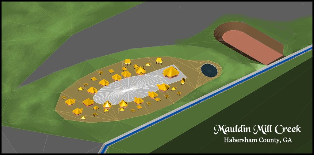
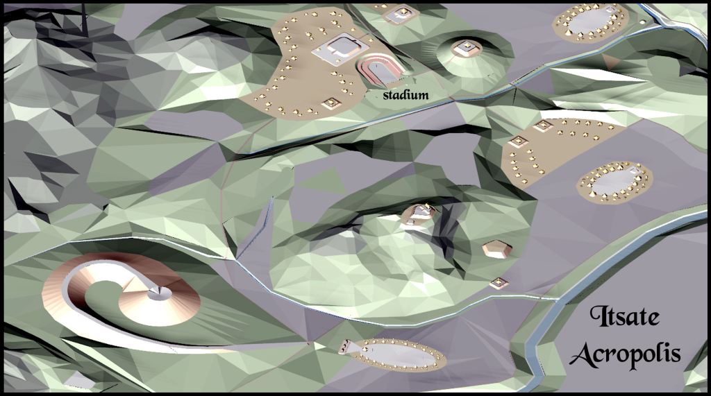
Mauldin Mill Creek town site
Mauldin Mill Creek is located on the eastern edge of the Nacoochee Valley. While hiking with a lady in a pasture behind her house, we came upon a Native American town site with Late Mississippian Period potsherds on the surface. Robert Wauchope mentioned artifacts being found in a plowed field here, but he did not do any excavations. One section of the town had been obviously excavated to create a horseshoe shaped stickball stadium . . . about the same size as the one at the community center in Sautee.
On the west side of the stadium is an egg-shaped pond, excavated into the creek’s flood plain. It was oriented to the Winter Solstice Sunset, which marked the beginning of the Maya New Year.
There has been no archaeological work at the Mauldin Mill Creek archaeological zone, so I am not certain how large or how old this community was. It may have been much larger than show on the virtual reality, architectural rendering above.
Future articles
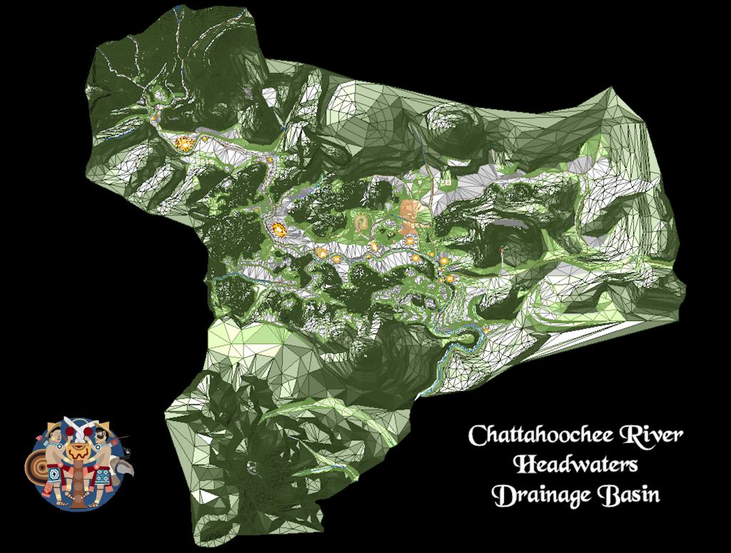
After sixteen months of work, the computer model of the 12 mile (19.3 km) long Chattahoochee River Headwaters Basin is now complete. Commonly known as the Nacoochee Valley, this archaeological zone contains the largest and densest concentration of human occupation sites in North America . . . dating from the Ice Age to the Georgia Gold Rush in the early 1800s. With it, we will be able to intimately explore what this Native American metropolis looked like 500 years ago. Readers will be my guests as we jump aboard a virtual time machine!