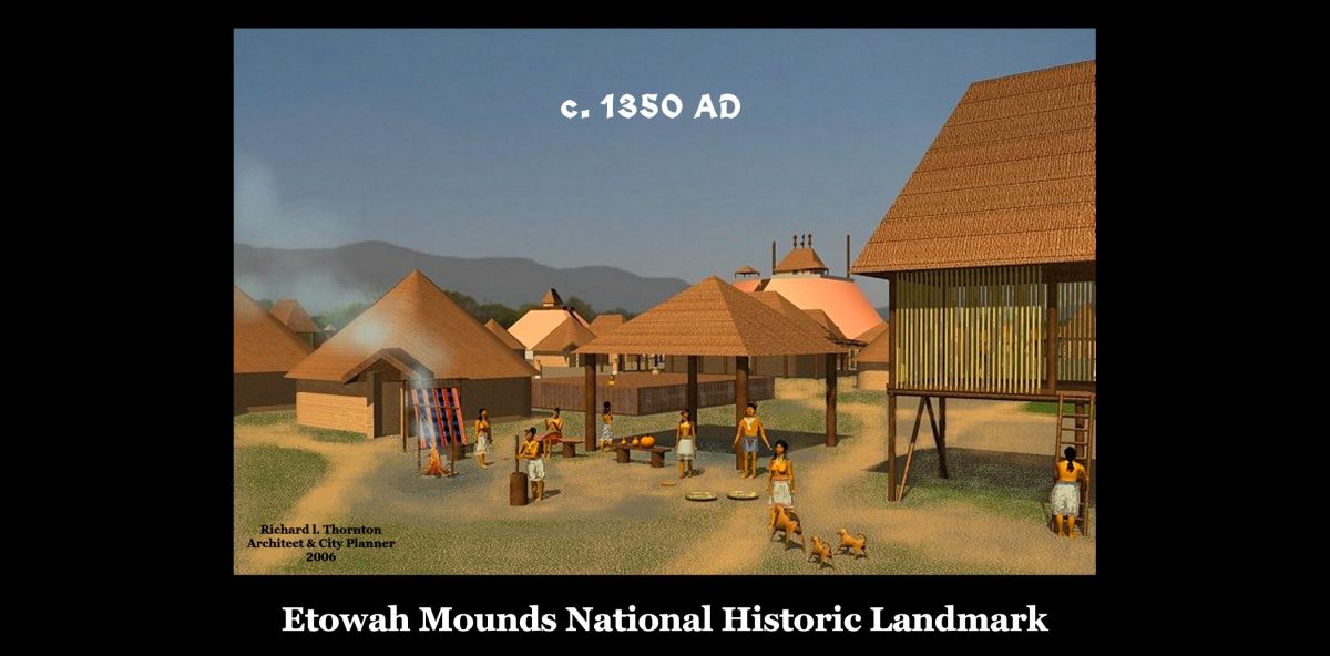
Etowah is the Anglicization of the Muskogee -nization of the Itza Maya and Itzate Creek word, Etula, which means “Principal Town.” It’s Muskogee deritive, Etalwa, has the same meaning.

In the mid-1990s, some professors with a hidden agenda, changed the exhibits and “official history” of the Etowah Mounds Museum to give the impression that the final occupants of the town were Cherokees, who had supposedly captured the town around 1585 AD.
They created a fairytale that the famous Etowah Marble statues were hastily buried at the top of a mound, while the victorious Cherokees were breaking through the walls of the town. Actually, the statues were found in a collapsed underground log temple, underneath Mound C.
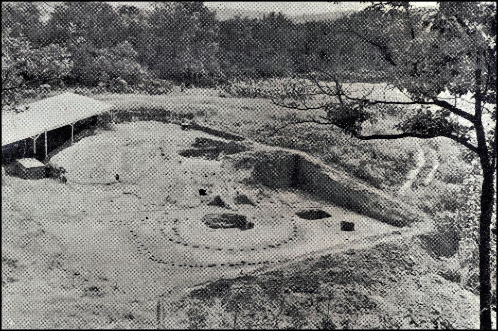
Photo taken by Dr, Arthur Kelly of the underground temple, where the two famous marble statues were discovered a few minutes earlier by Dr. Lewis Larson. The fairytale version of the unearthing of these statues at the top of Mound C is absolutely impossible, since the upper half of Mound C was destroyed by laborers, employed by the Smithsonian Institute, in 1885.
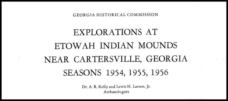
The photo above of an excavated Mound C is from the Kelly-Larson Archaeological Report, which contemporary anthropology students are told, “never existed.”
Beginning around the year 2000, beloved actor and Waycross, GA Native, Pernell Roberts* encouraged and gave some financial support to an informal group of Creek and Chickasaw professionals/professors, who were determined to fight the false Native American history being spewed forth from some state/local bureaucrats and certain University of Georgia professors. However, we were never able to correct the false information being presented by the new exhibits at the Etowah Museum.
*My parents were good friends and attended church with Pernell’s parents, when we lived in Waycross.
by Richard L. Thornton, Architect & City Planner
Background
Very few people today . . . even anthropology professors . . . know that the original height of Etowah Mound A was about 102 feet (30 m), not 63 feet. Fifteen feet of the base were covered by sand during a catastrophic flood in 1886, It has lost about 24 feet from the top due to compaction, erosion from hundreds of rainstorms, digging by artifact collectors and soil being blown away by the wind.
Even though they are used repeatedly by archaeologists and anthropology professors, all artistic portrayals of Etowah Mounds in the museum are inaccurate and do not reflect the buildings and mounds unearthed by archaeologists in the past. Most of the art is from the October 1991 National Geo article on Etowah Mounds, written by my friend, George Stuart. They were painted by an artist in the Midwest, hired by National Geographic Magazine,
I was stunned by the “tall tales” and inaccurate art in the article, since Gene Stuart observed the entire excavation and had Dr. Kelly as her professor in many classes. George worked there one summer. When I telephoned Gene about this, there was dead silence for awhile, like a gun had been put to her head. She eventually responded, “Richard, George had to write what the professors at Georgia told him to write. He had no choice in the matter. I really can’t say anymore”
In 2004, leaders of the Muscogee Creek Nation immediately recognized the serious inaccuracies in the remodeled museum, after I gave them one of my Etowah Mounds Archaeological Reports. In 2005, They instructed me to thoroughly read all archaeological reports for Proto-Creek towns along the Etowah River then produce precise architectural renderings, which exactly matched the descriptions by professional archaeologists. One of those drawings is at the top of the article.
The Georgia Parks and Historic Sites Division refused to display those virtual reality images along with art produced by Oklahoma Muskogee-Creeks, because “it would upset the Cherokees up in North Carolina,” Repeated insults like this eventually resulted in 2024 acquistion of all burial artifacts in the museum by the Muskogee Creek Nation and their replacement with murals and paintings by Creek artists.
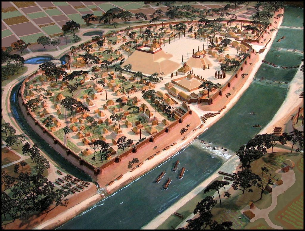
In 2006, the Muskogee-Creek National Council wanted a precise model of Etowah around 1375 AD, built by a professional architect, based on ground penetrating radar scans and infrared imagery, to counter the inaccurate paintings and dioramas in the Etowah Mounds Museum. The original plans were to leave it on display at the Etowah Mounds Museum for several months or even till an archaeological museum was constructed in Okmulgee, Oklahoma. This model is 6 ft. by 8 ft. and was built upon an enlarged satillite infrared photo of the site.
The Georgia Parks and Historic Sites Division refused to display this model, claiming that “there was no truck available to move it the 20 miles from the model shop in Jasper, GA to Cartersville, GA.” Therefore, the Muskogee-Creek Nation moved it over 800 miles to Okmulgee, OK , where it was placed under the Great Seal of the tribe. It will soon grace a new archaeological museum in Okmulgee, presumably containing some artifacts from the Etowah Mounds Museum in Georgia,.
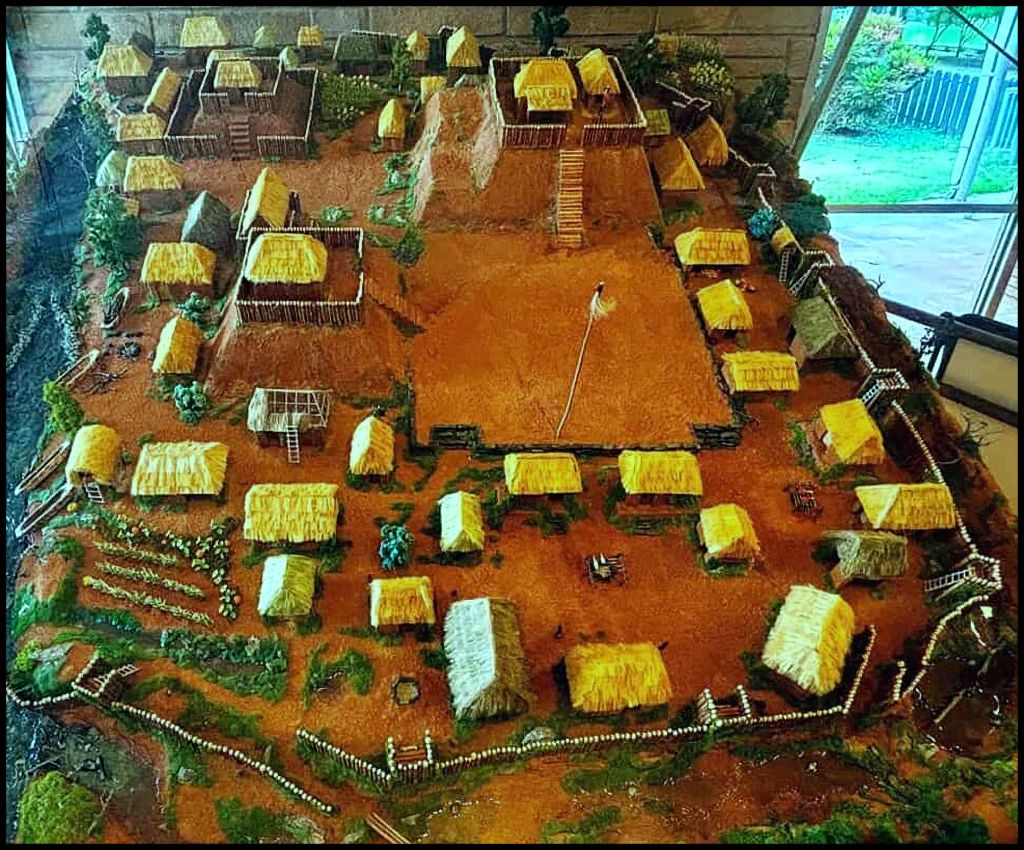
The model in the museum lobby was created by a high school student in 2007, whose parents made a donation to the museum. It does not portray any building or public space at Etowah Mounds accurately, yet with the advent of Youtube is utilized repeatedly as major image for videos. The craftsmanship of the model is acceptable. It just does not portray Etula.
Even the professors nowadays seem unaware that Mound A was radically altered in the 1800s and that Mounds B and C were created by laborers working for the Georgia Historical Commission. They are not the shape or size of the original mounds, plus are not quite in the same locations. I know of at least one doctoral dissertation, which was base on extreme analysis of the mounds built by workers in the late 1950s.
Two years after the museum reopened in 1995, politically-powerful economic interests began planning “Cherokee” gambling casinos near Etowah Mounds, Track Rock Gap, the site of Coosa on Carters Lake, near I-75 in Adairsville, GA and next to a large satellite town of Etowah Mounds in Ball Ground, GA.
During that period, I was Principal Planner of Cobb County, GA in NW Metro Atlanta. My secret girlfriend from when we both lived in the Shenandoah Valley, FBI Special Agent Susan Karlson, operated covertly out of her real estate law practice in East Cobb. She noticed that suddenly “Historic Preservation Planner” slots in both the state and local governments were being filled with young women, whose parents had moved to Georgia from other parts of the nation and had connections with organized crime. Even the Community Development Director of Cobb County had ties to organized crime.
Having grown up in Scandinavia, Susan didn’t know much about Georgia’s early history. However, she was keeping watch on these moles for organized crime. She noticed that despite being right out of college they were churning out many articles and maps to the news media.
She asked me to look at the maps and press releases. They were caca de toro. They showed the Cherokees always occupying the portion of Georgia from Savannah northward, when in fact, the Cherokees had very little presence in Georgia until after the Revolution. The map completely left out many tribes like the Chickasaw, Kansa, Yamacraw (Chontal Mayas) and Uchee, who had occupied large swaths of Georgia.
I couldn’t understand why organized crime would give a flying flip about Georgia’s Pre-Columbian history. Susan responded, “It’s the casinos, Richard! Organized crime operations are worming their people into the Indian casinos, who then hire Mafia-owned vendors. They jack up the prices and make vast profits off of what appears to be legitimate business services, They also like to control the real estate around the casinos. “
By 2010, the push for developing Native American casinos in North Georgia, waned because a new generation of politicians in both major parties realized that the state government would get zero income from them and that the vast majority of their constituents did not want gambling casinos in the state.
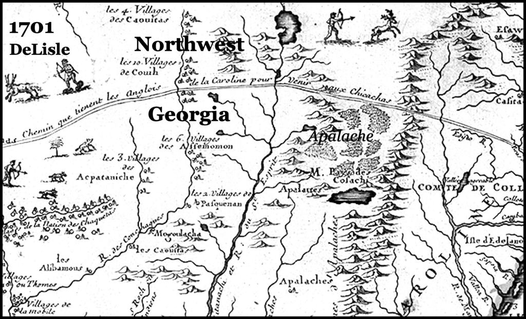
Map by French Royal Geographer Guillaume de l’Isle, based on expeditions by French Marines and land surveyors – Until around 1750, most Creeks called themselves Apalache, Apalachete or Apalachicola.The Coweta Creeks called themselves the Coweta branch of the Apalache. Upper Creeks called themselves Kaushete (Cusate), The Chickasaws in Georgia were members of the Creek Confederacy. They lived north of the Coosawttee River in NW Georgia and south of Yonah Mountain in NE Georgia. The first French map to show Cherokees living in North Carolina was published in 1717. Yhe lake on the right of the map is the Nacoochee Valley, which at that time flooded in the springtime.
The Basic Facts
In August, while writing an article about my friendship with the famous National Geo archaeologists, George and Gene Stuart, I suddenly realized that I was about the last man standing. My lifestyle and interests have changed little since 1977, when my former wife and I moved to an old farm at the head of the Reems Creek Valley, north of Asheville, NC. Thus, I always thought of myself as a young Davy Crockett. LOL
In truth, though, I was one of the few people still alive, who personally knew the archeologists, who excavated Etowah Mounds or watched it being excavated. There were probably not many more people left, who remembered what the museum looked like inside, before being remodeled in the mid-1990s.
I will never forget the first time I saw Etowah in my early teens. The minister of Red Oak Methodist Church, the Rev. Paul Harwell took a youth of our church on a field trip there. He was of Creek descent and had an anthropology degree then felt the call of the ministry and obtain a ThD from Emory University. We walked from the shop area into a room containing the simulated burial of a seven feet tall Creek king. Paul pointed at the replica skeleton and said, “Richard, this could be one of your ancestors.” My mother had said exactly the same thing, when I was six and we visited Ocmulgee.
While at Georgia Tech, I had prepared graphics of a town site for Dr. Arthur Kelly, Chief Archaeologist at Ocmulgee and Etowah. Dr. Lewis Larson, his colleague at Etowah, taught anthropology at Georgia Tech. Both of them gave my class guided tours of Etowah, when I taught Pre-Columbian Architecture at Georgia Tech. Architecture professor Julian Harris designed the Etowah Museum. I had him as a professor all five years at Tech, plus he was chairman of the faculty committee that selected me for the Barrett Fellowship.
George Stuart was a college student in South Carolina, when he worked one summer at Etowah, under Kelly’s supervision. His work caught the attention of the National Geographic Society, who hired him as soon as graduated from the University of South Carolina.
Gene Strickland was a newly minted school teacher from South Carolina, living in a house near Etowah Mounds, when the excavations started. She went by there almost every day during the summers and eventually began taking classes in anthropology and archaeology at the University of Georgia, taught by Dr. Kelly. She eventually became a full-time anthropology student at UGA and graduated with a Master’s Degree.
The handsome college student from South Carolina caught her eye. Sparks flew . . . but they did not permanently tie the knot until several years later when she intentionally moved to Washington, DC and obtained a job with National Geo Magazine in order to snare George. Gene would never tell me what happened in Cartersville. The two of them became good friends during the last ten years of her life. Alas, like my good friend Gene, all the people above have now passed away.
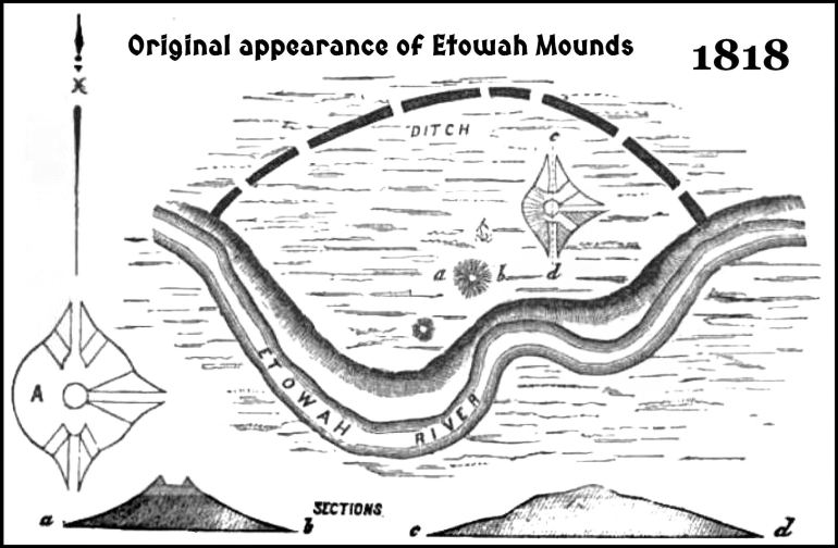
Site plan and elevations by Professor Elias Cornelius
1. All 17th and 18th century French maps showed Northwest Georgia occupied by Creeks and Chickasaw. The 17th century maps show a large town, approximately where Etowah Mounds is located. Eighteenth century French and English Maps do not show a large town at that location.
2. In 1818, Elias Cornelius, a Natural Science professor at Yale College, became the first scholar to study and survey Etowah Mounds. His Cherokee guides told him that the first Cherokees had arrived in the Etowah Valley about 20 years earlier. They never lived near the mounds, because they were haunted. They did not know who built the mounds or when they were built. Cornelius asked his Cherokee assistants to cut down the largest tree in the vicinity of the mounds. He counted the tree rings and determined it to be a little over 100 years old. From that information he speculated that the town site had been abandoned around 1700-1715. He then surveyed all the land within the moat and drew Etowah’s first site plan.
3. From 1832 till 1953, the Tumlin Family farmed all or portions of the town of Etula. The largest mound was altered to allow mule wagons and plows to cultivate the top. The Tumlins also charged $200 a month to amateur artifact collectors, who could dig anywhere within the town site.
4. During the summer and fall of 1864, the First Ohio Volunteer Infantry Regiment was stationed literally in the Etowah Mounds town site. They altered the earthworks, in particular, Mound A and the younger mounds on the east side of the town to make artillery positions. During that period of time, hundreds, if not thousands of Native American artifacts on display or stored in homes and stores in Cartersville, went missing.
Coincidence? Col. Gates P. Thruston was commander of this regiment. At the end of the Civil War, he had a collection of several thousand Native American artifacts, which he claimed to have purchased from soldiers while the fortifications of Nashville were being constructed. There are some issues with this claim. He was not in Nashville when the fortifications were built and those fortifications did not involve the destruction of any mounds or stone box graves. They were all in the flood plain next to the river, His collection became the basis of the State Museum in downtown Nashville.
5. In 1884 and 1885, the Smithsonian Institute excavated much of Mound C. The supervising “archaeologist” was Joe P. Rogan, whose only qualifications were being an unemployed Union veteran and a cousin of the Chief Archaeologist for the Smithsonian’s Bureau of Ethnology, Cyrus Thomas. Typically, while unskilled workers shoveled away on Mound C, Rogan was devouring much older mounds on the southn aide of the river. Rogan sold those discoveries to private collectors. All of the artifacts were hauled up to Washington DC, but many ended up in Northeastern museums and private residences.
Rogan was eventually fired from Etowah for not producing enough trophy artifacts. He was then rehired to excavate the infamous Bat Creek Mound, but was soon fired again for the same reason as before. Nevertheless, he returned to Cartersville to hire an architect to design what would be one of the largest brick commmercial buildings , north of Atlanta The 1888 Rogan Building. He continued to advertise his services for “gentlemen of means, wishing to excavate American Indian artifacts.”
6, In 1886, a horrific flood occured on the Etowah and Coosa River Basin. It covered the Etowah Archaeological Zone with up to 15 feet of sandy silt. It also changed the channel of the Etowah River.
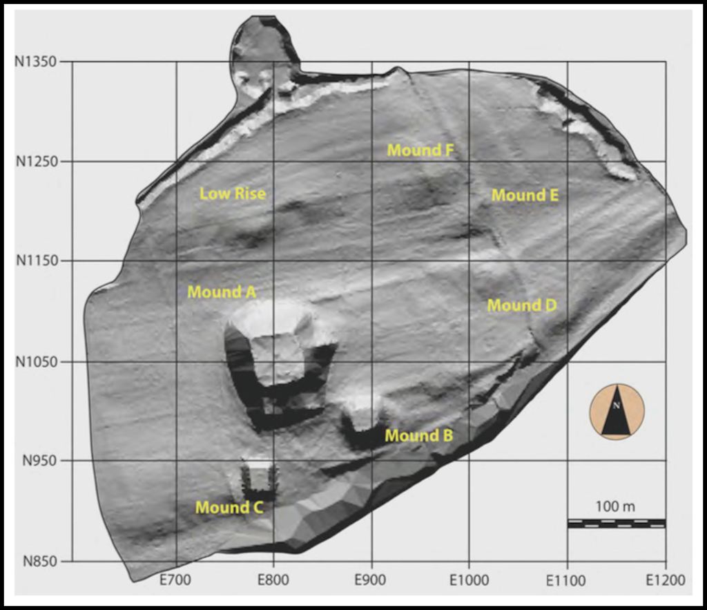
This is a ground penetrating radar image of Etowah Mounds from 2006 and 2007, By comparing this image with the site plan of Elias Cornelias, one can see how much of the river front portion of the town was eaten away by the 1886 Flood.
7. In 1925, Archaeologist Warren K, Moorehead excavated all of Mound C that was visible above the current grade.
8. In 1954, the Georgia Historical Commission purchased the visible portions of the Town of Etula, north of the Etowah River. Just as much of the town has remained in private hands. Originally, around 1000 AD, the Etowah River flowed along the northern edge of the town, but during a catastrophic flood around 1200 AD, changed its channel and split the town in half.
9. Once the meuseum, designed by Architect Julian Harris was completed, Etowah Mounds became one of the most important tourist attractions in Georgia for several decades.
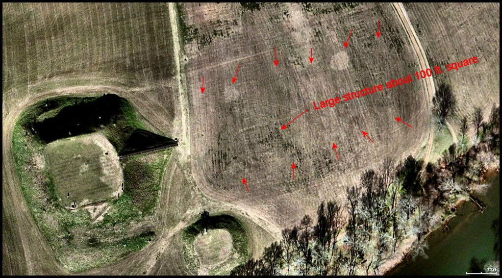
Near visible infrared photography provides the faint footprints of ancient structures, which once were sitting on the plaza during the fourth occupation of Etowah Mounds. Note that my infrared scan deteceted many structures that are not visible on the ground radar scan above.
10. During the years 1970, 1971 and 1972, I was first a student then the instructor for Georgia Tech’s Pre-Columbian Archiecture course. A highpoint of the class was always the field trip to Etowah Mounds. Arthur Kelly, Lewis Larson and Julian Harris provided us unforgettable VIP tours of the site. However, Dr. Kelly’s aerial photograph (see below) provided cookie-cutter crisp depictions of these same structures seen faintly in my infrared scan.
One of the most interesting parts of the famous professionals presentation was the explanation of how archaeologists find buildings when there is nothing visible there, like a large Indian mound. This was back when there was no such thing as ground radar and infrared satellite photos. There were no satellites.
Dr. Kelly took outside to the plaza area and told us to look at the grass. Back in 1954, during the cooler months, grass grew faster above the locations of buildings than elsewhere. The grass still behaved that way in the early 1970s.
Acting on a hunch that Etowah had actually been occupied in fairly recent times, Dr. Kelly requested that the grass sod be peeled off the central area of Etowah Mounds by a skilled grading contractor. He then ordered high resolution photos.
Amazing! Dozens of structures were visible in such precision that on the photograph, they looked like they had been painted onto the soil. I will never forget that photo.
Radio-carbon dating was not readily available in the Southeast in the mid-1950s, but when Dr. Kelly excavated the dark circles and rectangles, he found a mixture of high quality Late Lamar (Creek) ceramics and European artifacts. That is what you would expect to find in the 1600s. He also unearthed in the plaza between the big mounds a large buildng that could hold at least 500 people, attending a banquet.
I requested that a digital copy of this aerial photo be emailed to me by the Laboratory of Archaeology at the University of Georgia. Nope! I was not a professional archaeologist or anthropology student, so that was forbidden, even though I had been shown the aerial photos personally by Dr. Arthur Kelly 56 years ago!
I went ahead and filled out the form for re-examining the old forgotten photo, but have not received a response. I pointed out in the application that my mother was probably the first Native American to attend the University of Georgia and that she graduated Summa Cum Laude, even though the only transportation her family had was a mule wagon!

